From Surf Wiki (app.surf) — the open knowledge base
Fort Shafter
United States Army Pacific headquarters in Honolulu, Hawaii, USA
United States Army Pacific headquarters in Honolulu, Hawaii, USA
| Field | Value |
|---|---|
| name | Fort Shafter |
| location | Honolulu, Hawaii |
| image | Richardson Hall.jpg |
| image_size | 250px |
| caption | Richardson Hall at Fort Shafter, nicknamed the "Pineapple Pentagon" |
| coordinates | |
| type | Army post |
| controlledby | U.S. Army |
| built | 1905-1907 |
| used | 1907 – present |
| battles | Attack on Pearl Harbor |
| current_commander | General Ronald P. Clark |
| past_commanders | General Charles Flynn |
| garrison | U.S. Army Pacific |
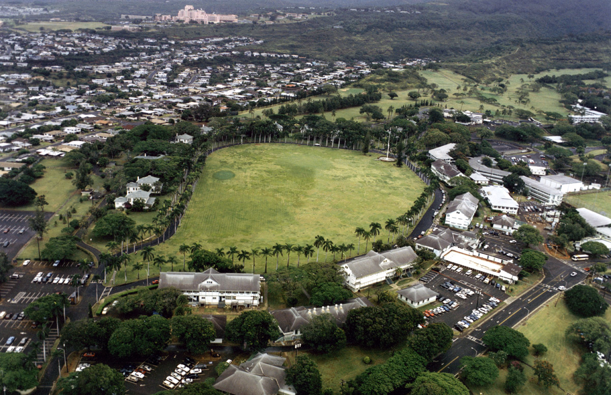
Fort Shafter is an army installation located in the City and County of Honolulu, Hawai‘i. It is the headquarters of the United States Army Pacific, which commands most Army forces in the Asia-Pacific region with the exception of Korea. Geographically, Fort Shafter extends up the interfluve (ridgeline) between Kalihi and Moanalua valleys, as well as onto the coastal plain (as Shafter Flats) at Māpunapuna. A portion of the area is also known as the Palm Circle Historic District; it is listed on the National Register of Historic Places and has been further designated as a U.S. National Historic Landmark. It is also known as Palm Circle or 100 Area.
It is located in the Urban Honolulu census-designated place.
History
Fort Shafter is the oldest military base on Oahu and celebrated its 100th birthday on 22 June 2007.
Fort Shafter has been home to the senior Army headquarters in Hawaii for a century. Construction began in 1905 on the ahupua'a of Kahauiki, former Hawaiian crown lands that were ceded to the United States government after annexation. When the post opened in 1907, it was named for Major General William Rufus Shafter (1835–1906), who led the United States expedition to Cuba in 1898.
Palm Circle was laid out as a cantonment for an infantry battalion. The barracks and officers' quarters were arranged around a parade field ringed by royal palms. The first unit stationed at the new post was the 2d Battalion, 20th Infantry Regiment.
Fort Shafter gradually spread out from Palm Circle. Tripler General Hospital once stood where the highway intersection is today (the hospital moved to its present location in 1948). In 1914, a regimental-sized cantonment area was constructed (near Richardson Theater). The Hawaiian Ordnance Depot was built in 1917 as a separate post (near today's post exchange). In 1921, the Hawaiian Department moved to Fort Shafter from downtown Honolulu. Finally, a new area was constructed in 1940 for Signal Corps elements.
War came to Fort Shafter on 7 December 1941, where the Hawaiian Department commander, Lieutenant General Walter C. Short, occupied Quarters 5. One soldier, Corporal Arthur A. Favreau, 64th Coast Artillery (Anti-Aircraft), was killed on post by an errant Navy shell. Fort Shafter became a busy headquarters and the barracks on Palm Circle were converted to offices. The major headquarters was named successively U.S. Army Forces, Central Pacific Area (1943–44); U.S. Army Forces, Pacific Ocean Areas (1944–45); and U.S. Army Forces, Middle Pacific (1945–47). In 1944, the Army Corps of Engineers erected the "Pineapple Pentagon" (buildings T-100, T-101, and T-102) in just 49 days. Two large fishponds were filled in to form Shafter Flats.
For most of the time since the Second World War, Fort Shafter has remained the senior Army headquarters for the Asia-Pacific region. In 1947, the headquarters was renamed U.S. Army, Pacific. The post continued to adapt to meet the Army's evolving requirements. In the early 1960s it was split in two by the new Moanalua Freeway. In 1974, when the headquarters was eliminated, Fort Shafter became home to U.S. Army Support Command, Hawaii, and the U.S. Army Corps of Engineers, Pacific Ocean Division (relocated from Fort Armstrong, (Hawaii)). In 1979, the Army established U.S. Army Western Command, which was renamed U.S. Army, Pacific in 1990. In 1983, the Army conveyed to the State of Hawaii 750 acre of undeveloped land on the northern end of post. Today Fort Shafter remains the focal point for command, control, and support of Army forces in the Asia-Pacific region; it includes an underground command center beneath Palm Circle.
Current Units
- [[File:USARPAC insignia.svg|50px]][[File:US Army Pacific DUI.gif|30px]]United States Army Pacific
- [[File:US IX Corps SSI.png|50px]]9th Mission Support Command
- [[File:18MedicalCmdSSI.jpg|50px]][[File:18MedicalCmdDUI.jpg|30px]]18th Medical Command
- [[File:94thAAMDC.png|50px]][[File:94th Army Air and Missile Defense Command.png|30px]]94th Army Air and Missile Defense Command
- [[File:311 Sig Cmd SSI.png|50px]][[File:311DUI.png|30px]]311th Signal Command (Theater)
- [[File:US Army - 516th Signal Brigade Shoulder Sleeve Insignia.png|50px]][[File:US Army 516th Signal Brigade DUI.png|30px]]516th Signal Brigade
- [[File:196InfBdeSSI.svg|50px]][[File:196 Inf Bde DUI.png|30px]]196th Infantry Brigade
Education
Hawaii Department of Education operates public schools. As of 2016 zoned schools are Shafter Elementary School, Moanalua Middle School, and Moanalua High School.
References
References
- Geography Division. (April 10, 2021). "2020 CENSUS - CENSUS BLOCK MAP: Urban Honolulu CDP, HI". [[U.S. Census Bureau]].
- (2019). "A Hypothesis Regarding the Army's Incinerator at Fort McDowell, Marin County, California". Articles of the SCA Proceedings.
- "Hawaii School Information School Year 2016-2017". Army Family and MWR Hawaii.
This article was imported from Wikipedia and is available under the Creative Commons Attribution-ShareAlike 4.0 License. Content has been adapted to SurfDoc format. Original contributors can be found on the article history page.
Ask Mako anything about Fort Shafter — get instant answers, deeper analysis, and related topics.
Research with MakoFree with your Surf account
Create a free account to save articles, ask Mako questions, and organize your research.
Sign up freeThis content may have been generated or modified by AI. CloudSurf Software LLC is not responsible for the accuracy, completeness, or reliability of AI-generated content. Always verify important information from primary sources.
Report