From Surf Wiki (app.surf) — the open knowledge base
Cumberland County, Pennsylvania
County in Pennsylvania, United States

County in Pennsylvania, United States
| Field | Value |
|---|---|
| county | Cumberland County |
| state | Pennsylvania |
| ex image | Carlisle, Pennsylvania (5656229890).jpg |
| ex image cap | Old Cumberland County Courthouse in Carlisle in April 2011 |
| seal | Seal of Cumberland County, Pennsylvania.png |
| flag | Flag of Cumberland County, Pennsylvania.gif |
| founded date | January 27 |
| founded year | 1750 |
| named for | Cumberland, England |
| seat wl | Carlisle |
| largest city wl | Carlisle |
| city type | borough |
| area_total_sq_mi | 550 |
| area_land_sq_mi | 545 |
| area_water_sq_mi | 4.8 |
| area percentage | 0.9% |
| census yr | 2020 |
| pop | 259469 |
| pop_est_as_of | 2024 |
| population_est | 275516 |
| density_sq_mi | auto |
| web | www.cumberlandcountypa.gov |
| time zone | Eastern |
| district | 10th |
| district2 | 13th |
| footnotes |
Cumberland County is a county in the Commonwealth of Pennsylvania. As of the 2020 census, the population was 259,469. Its county seat is Carlisle. Cumberland County is included in the Harrisburg–Carlisle metropolitan statistical area. The county is part of the South Central region of the commonwealth.
History


Cumberland County was first settled by a majority of Scots-Irish immigrants who arrived in approximately 1730. English and German settlers constituted about ten percent of the early population. The settlers originally mostly devoted the area to farming and later developed other trades. These settlers built the Middle Spring Presbyterian Church, among the oldest houses of worship in central Pennsylvania, in 1738 near present-day Shippensburg, Pennsylvania.
The General Assembly (legislature) of the Pennsylvania colony on January 27, 1750, created Cumberland County from Lancaster County, Pennsylvania, naming it for Cumberland, England. Its county seat is Carlisle. The county also lies within the Cumberland Valley adjoining the Susquehanna River at its eastern border, stretching approximately 42 miles from the borough of Shippensburg on the west to the Susquehanna River in east Cumberland County.
The oldest towns in the county are Shippensburg and Carlisle, each with its unique history. Shippensburg is home to Shippensburg University of Pennsylvania, one of 14 universities of the Pennsylvania State System of Higher Education. Carlisle is also home to Dickinson College, established in 1773, and the Penn State Dickinson School of Law.
The United States Army War College is a United States Army school located in Carlisle, Pennsylvania, on the 500 acre campus of the historic Carlisle Barracks, a military post dating back to the 1770s. It caters to high-level military personnel and civilians and prepares them for strategic leadership responsibilities. It is the U. S. Army's most senior military educational institution.
During the Gettysburg campaign of the American Civil War in the summer of 1863, Confederate troops marched through the Cumberland Valley, briefly occupying much of the county.
In the 20th century, the suburbs of Harrisburg, the state capital, expanded extensively into eastern Cumberland County. Carlisle also developed suburbs in adjoining townships.
Geography
According to the U.S. Census Bureau, the county has a total area of 550 sqmi, of which 545 sqmi is land and 4.8 sqmi (0.9%) is water. The area code is 717 with an overlay of 223. Blue Mountain forms Cumberland's northern natural boundary and Yellow Breeches Creek forms part of its SE natural boundary. The Susquehanna River drains the county and forms its eastern natural boundary. A large portion of Cumberland is drained by the Conodoguinet Creek, which winds its way west-to-east across the county into the Susquehanna.
Climate
Almost all of Cumberland has a hot-summer humid continental climate (Dfa) and its hardiness zone is 7a, except in small higher areas near the NW and SW boundaries, where it is 6b. Average monthly temperatures in Lemoyne range from 29.9 °F in January to 74.9 °F in July, in Carlisle they range from 29.8 °F in January to 75.2 °F in July, and in Shippensburg they range from 29.6 °F in January to 74.6 °F in July. The latest temperature averages show some low-lying eastern areas of the county to have a humid subtropical climate (Cfa.) |Jan record high F = 73 |Feb record high F = 83 |Mar record high F = 86 |Apr record high F = 93 |May record high F = 97 |Jun record high F = 100 |Jul record high F = 107 |Aug record high F = 101 |Sep record high F = 102 |Oct record high F = 97 |Nov record high F = 84 |Dec record high F = 75 |year record high F = 107 |Jan record low F = -9 |Feb record low F = -5 |Mar record low F = 2 |Apr record low F = 19 |May record low F = 31 |Jun record low F = 40 |Jul record low F = 49 |Aug record low F = 45 |Sep record low F = 30 |Oct record low F = 23 |Nov record low F = 13 |Dec record low F = -8 |year record low F= -9 |archive-date = July 5, 2012 |archive-url = https://web.archive.org/web/20120705132003/https://w2.weather.gov/climate/xmacis.php?wfo=ctp |url-status = dead
Adjacent counties
- Perry County (north)
- Dauphin County (east)
- York County (southeast)
- Adams County (south)
- Franklin County (southwest)
Major highways
State protected areas
- Colonel Denning State Park
- Kings Gap Environmental Education and Training Center
- Pine Grove Furnace State Park
Demographics
|align-fn=center 1790-1960 1900-1990 1990-2000 2010-2019
2020 census
As of the 2020 census, the county had a population of 259,469. The median age was 40.8 years. 20.4% of residents were under the age of 18 and 19.5% of residents were 65 years of age or older. For every 100 females there were 96.5 males, and for every 100 females age 18 and over there were 94.5 males age 18 and over.
The racial makeup of the county was 82.8% White, 4.3% Black or African American, 0.2% American Indian and Alaska Native, 5.4% Asian,
79.1% of residents lived in urban areas, while 20.9% lived in rural areas.
There were 103,405 households in the county, of which 27.7% had children under the age of 18 living in them. Of all households, 51.0% were married-couple households, 17.0% were households with a male householder and no spouse or partner present, and 25.2% were households with a female householder and no spouse or partner present. About 28.9% of all households were made up of individuals and 12.8% had someone living alone who was 65 years of age or older.
There were 109,125 housing units, of which 5.2% were vacant. Among occupied housing units, 69.5% were owner-occupied and 30.5% were renter-occupied. The homeowner vacancy rate was 1.1% and the rental vacancy rate was 6.0%.
| Race / Ethnicity (NH = Non-Hispanic) | title=P004: Hispanic or Latino, and Not Hispanic or Latino by Race – 2000: DEC Summary File 1 – Cumberland County, Pennsylvania | url=https://data.census.gov/table/DECENNIALSF12000.P004?q=P004:+HISPANIC+OR+LATINO,+AND+NOT+HISPANIC+OR+LATINO+BY+RACE+[73]&g=050XX00US42041 | publisher=United States Census Bureau | access-date= }} | title=P2 Hispanic or Latino, and Not Hispanic or Latino by Race – 2010: DEC Redistricting Data (PL 94-171) - Cumberland County, Pennsylvania | url=https://data.census.gov/table/DECENNIALPL2010.P2?q=p2&g=050XX00US42041 | website=United States Census Bureau}} | % 2000 | % 2010 |
|---|---|---|---|---|---|---|---|---|---|
| White alone (NH) | 199,925 | 210,514 | 211,990 | 93.56% | |||||
| Black or African American alone (NH) | 4,959 | 7,237 | 10,581 | 2.32% | |||||
| Native American or Alaska Native alone (NH) | 251 | 293 | 318 | 0.11% | |||||
| Asian alone (NH) | 3,556 | 7,028 | 13,836 | 1.66% | |||||
| Pacific Islander alone (NH) | 66 | 60 | 113 | 0.03% | |||||
| Other race alone (NH) | 183 | 229 | 1,074 | 0.08% | |||||
| Mixed race or Multiracial (NH) | 1,851 | 3,597 | 9,582 | 0.86% | |||||
| Hispanic or Latino (any race) | 2,883 | 6,448 | 11,975 | 1.24% | |||||
| Total | 213,674 | 235,406 | 259,469 | 100.00% |
2000 census
At the census of 2000, there were 213,674 people, 83,015 households, and 56,118 families residing in the county. The population density was 388 PD/sqmi. There were 86,951 housing units at an average density of 158 /mi2. The racial makeup of the county was 94.40% White, 2.36% Black or African American, 0.13% Native American, 1.67% Asian, 0.04% Pacific Islander, 0.43% from other races, and 0.97% from two or more races. 1.35% of the population were Hispanic or Latino of any race. 35.3% were of German, 10.6% American, 10.1% Irish, 7.5% English and 6.8% Italian ancestry. 94.7% spoke English and 1.4% Spanish as their first language.
There were 83,015 households, out of which 29.50% had children under the age of 18 living with them, 56.50% were married couples living together, 8.00% had a female householder with no husband present, and 32.40% were non-families. 26.70% of all households were made up of individuals, and 10.30% had someone living alone who was 65 years of age or older. The average household size was 2.41 and the average family size was 2.92.
In the county, the population was spread out, with 22.00% under the age of 18, 10.60% from 18 to 24, 28.50% from 25 to 44, 24.10% from 45 to 64, and 14.90% who were 65 years of age or older. The median age was 38 years. For every 100 females, there were 95.20 males. For every 100 females age 18 and over, there were 92.70 males.
Its per capita income is $31,627, making it the wealthiest Pennsylvania county outside greater Philadelphia, and fifth wealthiest overall.
Metropolitan Statistical Area
The United States Office of Management and Budget has designated Cumberland County as part of the Harrisburg-Carlisle, PA Metropolitan Statistical Area (MSA). As of the 2010 U.S. census the metropolitan area ranked 6th most populous in the State of Pennsylvania and the 96th most populous in the United States with a population of 549,475. Cumberland County is also a part of the larger Harrisburg–York–Lebanon combined statistical area (CSA), which combines the populations of Cumberland County as well as Adams, Dauphin, Lebanon, Perry and York Counties in Pennsylvania. The Combined Statistical Area ranked 5th in the State of Pennsylvania and 43rd most populous in the United States with a population of 1,219,422.
Government and politics
Cumberland County has been a Republican Party stronghold in presidential contests since McKinley's election in 1896, with only five Democratic Party candidates winning the county. The most recent Democrat to win the county in a presidential election was Lyndon B. Johnson in 1964 who won in a landslide statewide & nationally. In 2024, Kamala Harris won 44.45% of the vote in the county, the highest percentage since 1964, despite losing Pennsylvania and the 2024 presidential election.
Voter registration
As of May 19, 2025, there are 179,481 registered voters in Cumberland County.
- Republican: 88,313 (49.20%)
- Democratic: 59,862 (33.35%)
- Independent: 24,624 (13.72%)
- Third Parties: 6,682 (3.72%)
The Republican Party has been dominant in Cumberland County politics since the 1890s, with the victories of Robert P. Casey for governor in 1990, Bob Casey Jr. for state treasurer in 2004, Tom Wolf for governor in 2018, and Josh Shapiro for governor in 2022 being among the few times where a statewide Democrat carried the county. All row offices and all legislative seats serving Cumberland are held by Republicans except for one State Representative.
County commissioners
- Gary Eichelberger, Independent
- Jean Foschi, Democrat
- Kelly Neiderer, Chairman, Republican
Other county offices
- Clerk of Courts, Dennis Lebo, Republican
- Controller, Alfred Whitcomb, Republican
- Coroner Charles Hall, Republican
- District Attorney, Seán M. McCormack, Republican
- Prothonotary, Dale Sabadish, Republican
- Recorder of Deeds, Tammy L. Shearer, Republican
- Register of Wills, Lisa M. Grayson, Esq., Republican
- Sheriff, Jody Smith, Republican
- Treasurer, Kelly Neiderer, Republican
State representatives
- Thomas Kutz, Republican, 87th district
- Sheryl M. Delozier, Republican, 88th district
- Nate Davidson, Democrat, 103rd district
- Torren C. Ecker, Republican, 193rd district
- Barbara Gleim, Republican, 199th district
State senators
- Dawn Keefer, Republican, 31st district
- Greg Rothman, Republican, 34th district
United States House of Representatives
- Scott Perry, Republican, 10th district
- John Joyce, Republican, 13th district
United States Senate
- John Fetterman, Democratic
- Dave McCormick, Republican
Education
Colleges and universities
- Central Pennsylvania College
- Dickinson College
- Messiah University
- Penn State Dickinson Law
- Shippensburg University of Pennsylvania
- U.S. Army War College
Community, junior and technical colleges
- ITT Technical Institute
Public school districts
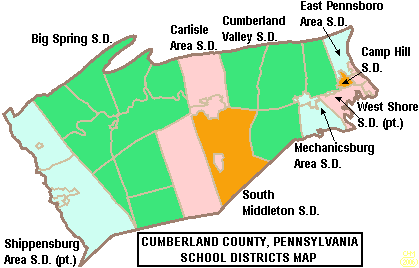
School districts include:
- Big Spring School District
- Camp Hill School District
- Carlisle Area School District
- Cumberland Valley School District
- East Pennsboro Area School District
- Mechanicsburg Area School District
- Shippensburg Area School District (also in Franklin County)
- South Middleton School District
- West Shore School District (also in York County)
Public charter schools
- Commonwealth Connections Academy Charter School - Mechanicsburg
Technical school
- Cumberland-Perry Area Vocational Technical School
Private schools
As reported by the National Center for Educational Statistics
- Allen Mennonite School - Dillsburg
- Berean Christian Day School - Newville
- Best Friends - New Cumberland
- Bethel Christian Academy - Carlisle
- Blue Ridge Mennonite School - Carlisle
- Brookside Montessori School - Camp Hill
- Chestnut Groove School - Shippensburg
- Children's School of New Cumberland - New Cumberland
- Dickinson College Children's Center - Carlisle
- Emmanuel Baptist Christian Academy - Mechanicsburg
- Faith Tabernacle School - Mechanicsburg
- Good Shepherd Elementary School - Camp Hill
- Harrisburg Academy - Wormleysburg
- Hickory Lane School - Newburg
- Hidden Valley School - Carlisle
- Kindercare Learning Center - Mechanicsburg
- Learning and Sharing - New Cumberland
- Logos School - Carlisle
- Living Faith School - Shippensburg
- Meadow Run - Newburg
- Mechanicsburg Learning Center - Mechanicsburg
- Middle Run Parochial School - Shippensburg
- Oak Grove Parochial School - Shippensburg
- Oakwood Baptist Day School - Camp Hill
- Otterbein School - Newburg
- Quarry Hill School - Newville
- Rocky View School Parochial - Newville
- South Mountain Parochial School - Shippensburg
- South Mountain Parochial School - Newville
- Spring Hill Parochial School - Shipensburg
- St. Joseph School - Mechanicsburg
- St Patrick School - Carlisle
- St Theresa Elementary School - New Cumberland
- Sunset Amish School - Newburg
- The Children's Garden of St Johns Lutheran Church - Shiremanstown
- The Christian School of Grace Baptist Church - Carlisle
- The Goddard School - Enola
- The Goddard School - Mechanicsburg
- The Learning Center - Camp Hill
- Trinity High School (Camp Hill, Pennsylvania)
- West Shore Christian Academy - Shiremanstown
- Yellow Breeches Education Center - Boiling Springs
Public libraries
Communities
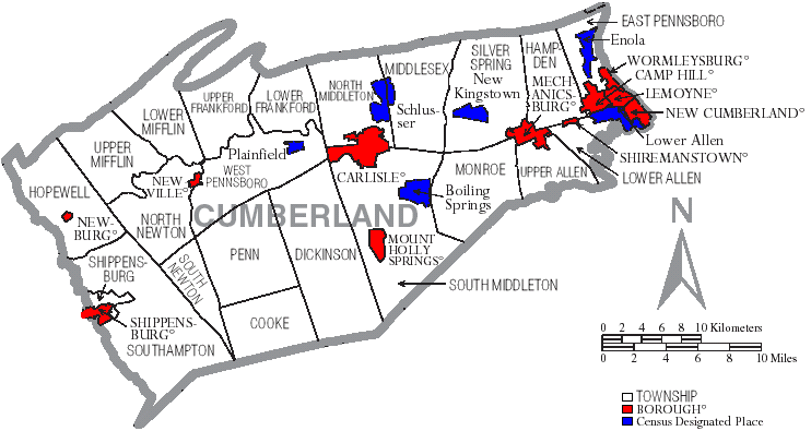
Under Pennsylvania law, there are four types of incorporated municipalities: cities, boroughs, townships, and, in at most two cases, towns. The following boroughs and townships are located in Cumberland County:
Boroughs
- Camp Hill
- Carlisle (county seat)
- Lemoyne
- Mechanicsburg
- Mount Holly Springs
- New Cumberland
- Newburg
- Newville
- Shippensburg (partly in Franklin County)
- Shiremanstown
- Wormleysburg
Townships
- Cooke
- Dickinson
- East Pennsboro
- Hampden
- Hopewell
- Lower Allen
- Lower Frankford
- Lower Mifflin
- Middlesex
- Monroe
- North Middleton
- North Newton
- Penn
- Shippensburg
- Silver Spring
- South Middleton
- South Newton
- Southampton
- Upper Allen
- Upper Frankford
- Upper Mifflin
- West Pennsboro
Census-designated places
Census-designated places are geographical areas designated by the U.S. Census Bureau for the purposes of compiling demographic data. They are not actual jurisdictions under Pennsylvania law. Other unincorporated communities, such as villages, may be listed here as well.
- Boiling Springs
- Carlisle Barracks
- Enola
- Lower Allen
- Messiah College
- New Kingstown
- Plainfield
- Schlusser
- Shippensburg University
- West Fairview
Unincorporated communities
- Bloserville
- Grantham
- Hogestown
- Huntsdale
- Lisburn
- Summerdale
- West Hill
Population ranking
The population ranking of the following table is based on the 2010 census of Cumberland County.
† county seat
| Rank | City/Town/etc. | Municipal type | Population (2010 Census) |
|---|---|---|---|
| 1 | † Carlisle | Borough | 18,682 |
| 2 | Mechanicsburg | Borough | 8,981 |
| 3 | Camp Hill | Borough | 7,888 |
| 4 | New Cumberland | Borough | 7,277 |
| 5 | Lower Allen | CDP | 6,694 |
| 6 | Enola | CDP | 6,111 |
| 7 | Shippensburg (partially in Franklin County) | Borough | 5,492 |
| 8 | Schlusser | CDP | 5,265 |
| 9 | Lemoyne | Borough | 4,553 |
| 10 | Boiling Springs | CDP | 3,225 |
| 11 | Wormleysburg | Borough | 3,070 |
| 12 | Shippensburg University | CDP | 2,625 |
| 13 | Messiah College | CDP | 2,215 |
| 14 | Mount Holly Springs | Borough | 2,030 |
| 15 | Shiremanstown | Borough | 1,569 |
| 16 | Newville | Borough | 1,326 |
| 17 | West Fairview | CDP | 1,282 |
| 18 | New Kingstown | CDP | 495 |
| 19 | Plainfield | CDP | 399 |
| 20 | Newburg | Borough | 336 |
Recreation
Annual events occur in downtown Carlisle at the Carlisle Fairgrounds. The Capital City Mall in Lower Allen Township serves the West Shore, the Carlisle area, and surrounding communities. Williams Grove Speedway is a half-mile auto-racing track in the county. The Appalachian Trail crosses the central part of Cumberland, which has two state parks:
- Colonel Denning State Park (also in Perry County)
- Pine Grove Furnace State Park (also in Adams County)
References
References
- "PHMC Historical Markers Search". Commonwealth of Pennsylvania.
- "Census - Geography Profile: Cumberland County, Pennsylvania". [[United States Census Bureau]].
- "Find a County". National Association of Counties.
- Wayland F. Dunaway, ''The Scotch-Irish of Colonial Pennsylvania''; University of North Carolina Press, 1944, p. 60.
- (August 22, 2012). "2010 Census Gazetteer Files". United States Census Bureau.
- "PRISM Climate Group at Oregon State University".
- "U.S. Decennial Census". United States Census Bureau.
- "Historical Census Browser". University of Virginia Library.
- (March 24, 1995). "Population of Counties by Decennial Census: 1900 to 1990". United States Census Bureau.
- (April 2, 2001). "Census 2000 PHC-T-4. Ranking Tables for Counties: 1990 and 2000". United States Census Bureau.
- "State & County QuickFacts". United States Census Bureau.
- "Census 2020".
- (2021). "2020 Decennial Census Demographic Profile (DP1)".
- (2021). "2020 Decennial Census Redistricting Data (Public Law 94-171)".
- (2023). "2020 Decennial Census Demographic and Housing Characteristics (DHC)".
- "P004: Hispanic or Latino, and Not Hispanic or Latino by Race – 2000: DEC Summary File 1 – Cumberland County, Pennsylvania". [[United States Census Bureau]].
- "P2 Hispanic or Latino, and Not Hispanic or Latino by Race – 2010: DEC Redistricting Data (PL 94-171) - Cumberland County, Pennsylvania".
- "P2 Hispanic or Latino, and Not Hispanic or Latino by Race – 2020: DEC Redistricting Data (PL 94-171) - Cumberland County, Pennsylvania".
- "U.S. Census website". [[United States Census Bureau]].
- "Office of Management and Budget".
- "2010 U.S. Census website". [[United States Census Bureau]].
- Leip, David. "Dave Leip's Atlas of U.S. Presidential Elections".
- (November 5, 2024). "2024 Senate Election (Official Returns)".
- Pennsylvania Department of State. (November 4, 2024). "Voter registration statistics by county".
- Weigel, John W.. (Summer 2000). "Free Soil: The Birth of the Republican Party in Cumberland County". Cumberland County History.
- (December 4, 2023). "Cumberland County commissioner breaks with local Republicans {{!}} PennLive/Patriot-News".
- "Meet the Commissioners {{!}} Cumberland County, PA - Official Website".
- Center, Legislativate Data Processing. "Find Your Legislator".
- Geography Division. (January 14, 2021). "2020 Census - School District Reference Map: Cumberland County, PA". [[U.S. Census Bureau]].
- Palleschi, Amanda. Enrollment in cyber charter schools booming in Pennsylvania despite friction with school districts, ''The Patriot News'', November 30, 2009
- Pennsylvania Department of Education - Operating Charter Schools in Pennsylvania Report. September 2009.
- ies, National Center for Education Statistics, US Department of Education, Institute of Education Sciences, Private School Universe Survey 2008
This article was imported from Wikipedia and is available under the Creative Commons Attribution-ShareAlike 4.0 License. Content has been adapted to SurfDoc format. Original contributors can be found on the article history page.
Ask Mako anything about Cumberland County, Pennsylvania — get instant answers, deeper analysis, and related topics.
Research with MakoFree with your Surf account
Create a free account to save articles, ask Mako questions, and organize your research.
Sign up freeThis content may have been generated or modified by AI. CloudSurf Software LLC is not responsible for the accuracy, completeness, or reliability of AI-generated content. Always verify important information from primary sources.
Report