From Surf Wiki (app.surf) — the open knowledge base
Zhigansky District
| Field | Value |
|---|---|
| en_name | Zhigansky District |
| ru_name | Жиганский улус |
| loc_name1 | Эдьигээн улууhа |
| loc_lang1 | Sakha |
| image_map | |
| map_caption | Location of Zhigansky District in the Sakha Republic |
| image_view | Northern noon - panoramio.jpg |
| image_caption | Northern noon, Zhigansky District |
| image_flag | Flag of Zhigansky rayon (Yakutia).svg |
| image_coa | Coat of Arms of Zhigansk rayon (Yakutia).png |
| federal_subject | Sakha Republic |
| federal_subject_ref | |
| adm_ctr_name | Zhigansk |
| adm_ctr_ref | |
| selsoviet_type1 | rural okrug |
| no_of_selsoviets_type1 | 4 |
| no_of_rural_localities | 5 |
| counts_ref | |
| mun_formation1 | Zhigansky Municipal District |
| mun_formation1_ref | |
| mun_formation1_no_of_urban_settlements | 0 |
| mun_formation1_no_of_rural_settlements | 4 |
| mun_formation1_counts_ref | |
| area_km2 | 140200 |
| area_km2_ref | |
| pop_2010census | 4296 |
| urban_pop_2010census | 0% |
| rural_pop_2010census | 100% |
| established_date | December 10, 1930 |
| established_date_ref | |
| website | https://mr-zhiganskij.sakha.gov.ru/ |
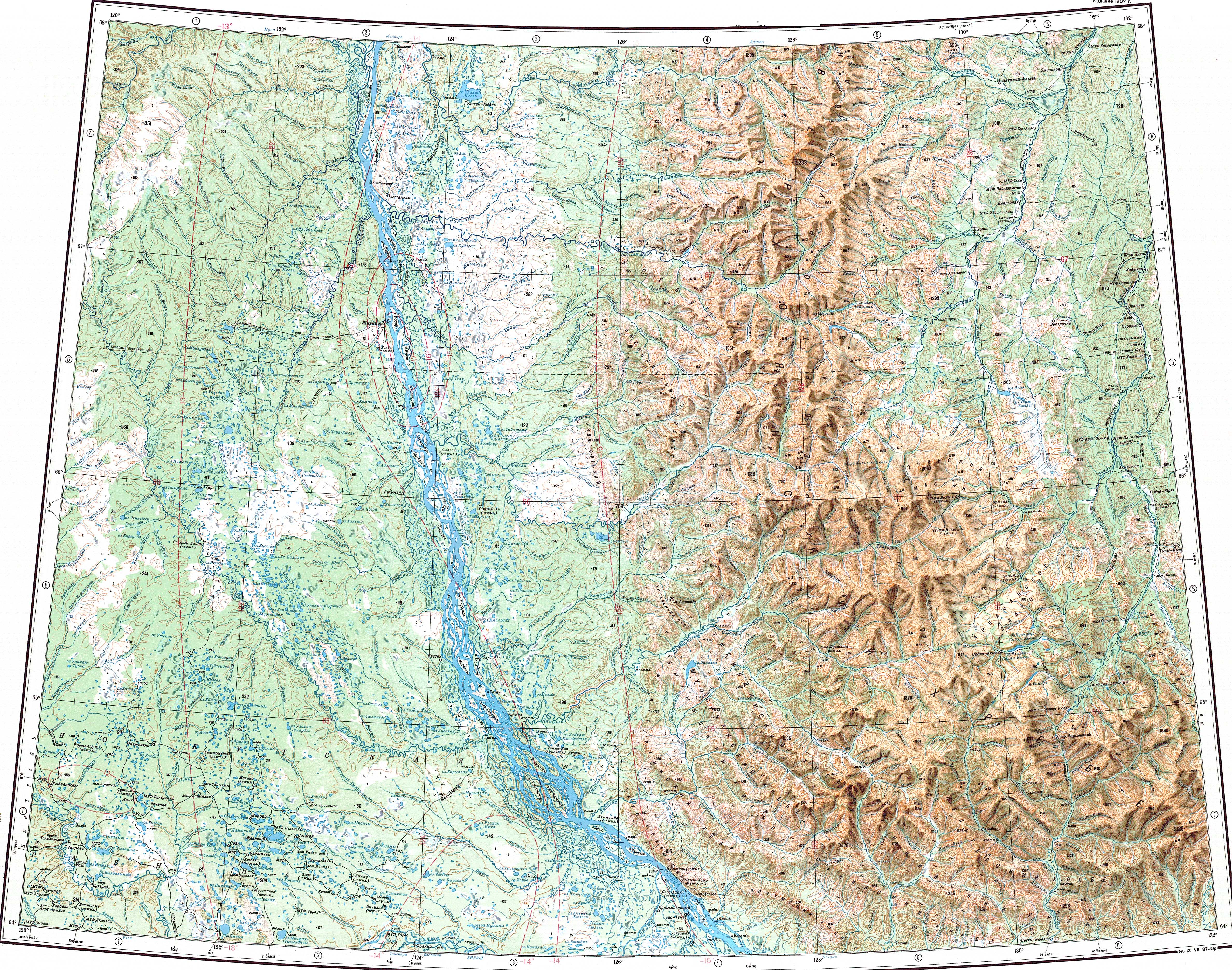
Zhigansky District (; ) is an administrative and municipal district (raion, or ulus), one of the thirty-four in the Sakha Republic, Russia. It is located in the northern central part of the republic and borders with Bulunsky District in the north, Eveno-Bytantaysky National District in the east, Kobyaysky District in the southeast, Vilyuysky District in the southwest, and with Olenyoksky District in the northwest. The area of the district is 140200 km2. Its administrative center is the rural locality (a selo) of Zhigansk. Population: 4,312 (2002 Census); The population of Zhigansk accounts for 79.6% of the district's total population.
Geography
The main river in the district is the Lena. Some of its important tributaries, such as the Menkere, Muna, Khoruongka, Nuora (Strekalovka), Kyuelenke and Motorchuna, have their mouth in the area of the district. The largest lake is Lake Ulakhan-Kyuyol.
Climate
Average January temperature ranges from -36 C in the east to -40 C in the west and average July temperature ranges from +14 C to +16 C. Annual precipitation ranges from 250 - in the west to 300 - in the east.
History
The district was established on December 10, 1930.
Demographics
As of the 2021 Census, the ethnic composition was as follows:
- Evenks: 63.0%
- Yakuts: 25.1%
- Russians: 9.1%
- other ethnicities: 2.8%
Inhabited localities
| Rural settlements | Population | Male | Female | Rural localities in jurisdiction* |
|---|---|---|---|---|
| Bestyakhsky Nasleg | ||||
| (Бестяхский наслег) | 218 | 111 (50.9%) | 107 (49.1%) | |
| Zhigansky Evenk National Nasleg | ||||
| (Жиганский эвенкийский национальный наслег) | 3,421 | 1,631 (47.8%) | 1,785 (52.2%) | |
| Kystatyam | ||||
| (Кыстатыам) | 397 | 202 (50.9%) | 195 (49.1%) | |
| Lindinsky Nasleg | ||||
| (Линдинский наслег) | 260 | 131 (50.4%) | 129 (49.6%) |
Divisional source:
Population source:
*Administrative centers are shown in bold
Note: The figures given in the table above include 2010 census reports of one person (male) living in the intersettlement territory, clarified in the regional census data as inhabiting Dzardzhan.
References
Notes
Sources
References
- Law #173-Z #354-III
- Constitution of the Sakha Republic
- Law #172-Z #351-III
- Registry of the Administrative-Territorial Divisions of the Sakha Republic
- {{ru-pop-ref. 2002Census
- "Топографска карта Q-51 52; M 1:1 000 000 - Topographic USSR Chart (in Russian)".
- [[Google Earth]]
- Center of the Socioeconomic and Political Monitoring. [http://www.sitc.ru/monitoring/zhigansk/index.shtml Zhigansky District] {{webarchive. link. (September 21, 2012 {{in lang). ru
- "Национальный состав населения". [[Federal State Statistics Service (Russia).
- [http://sakha.gov.ru/node/12543 Olenyoksy Ulus (Raion)] {{webarchive. link. (November 11, 2013 Official website of the Sakha Republic)
- Sakha Republic Territorial Branch of the [[Russian Federal State Statistics Service. Federal State Statistics Service]]. Results of the 2010 All-Russian Census. [http://sakha.gks.ru/wps/wcm/connect/rosstat_ts/sakha/resources/4c22eb804e8ba4699a749f7904886701/01-05.xls Численность населения по районам, городским и сельским населённым пунктам] (''Population Counts by Districts, Urban and Rural Inhabited Localities'') {{in lang. ru
This article was imported from Wikipedia and is available under the Creative Commons Attribution-ShareAlike 4.0 License. Content has been adapted to SurfDoc format. Original contributors can be found on the article history page.
Ask Mako anything about Zhigansky District — get instant answers, deeper analysis, and related topics.
Research with MakoFree with your Surf account
Create a free account to save articles, ask Mako questions, and organize your research.
Sign up freeThis content may have been generated or modified by AI. CloudSurf Software LLC is not responsible for the accuracy, completeness, or reliability of AI-generated content. Always verify important information from primary sources.
Report