From Surf Wiki (app.surf) — the open knowledge base
Zawata
| Field | Value |
|---|---|
| name | Zawata |
| translit_lang1 | Arabic |
| translit_lang1_type | Arabic |
| translit_lang1_info | زواتا |
| type | Municipality type D (Village council) |
| image_skyline | Zwata8028.JPG |
| image_caption | Zawata, 2016 |
| pushpin_map | Palestine |
| pushpin_map_caption | Location of Zawata within Palestine |
| coordinates | |
| grid_name | Palestine grid |
| grid_position | 171/183 |
| subdivision_type | State |
| subdivision_name | State of Palestine |
| subdivision_type1 | Governorate |
| subdivision_name1 | Nablus |
| established_title | Founded |
| government_footnotes | tags -- |
| government_type | Village council |
| unit_pref | dunam |
| population_footnotes | |
| population_total | 2537 |
| population_as_of | 2017 |
| population_density_km2 | auto |
| blank_name_sec1 | Name meaning |
| blank_info_sec1 | Zawata, personal name |
Zawata () is a town in the Nablus Governorate in the northern West Bank, Palestine, located 6 kilometers northwest of Nablus. According to the Palestinian Central Bureau of Statistics (PCBS), the town had a population of 2,537 inhabitants in 2017.
Location
Zawata is located 4.4 km north of Nablus. It has Ijnisinya and ‘Asira ash Shamaliya to the east, Ijnisinya and An Naqura to the north, An Naqura and Beit Iba to the west, and Beit Iba and Nablus to the south.
History
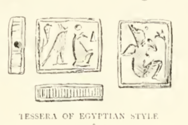
Clermont-Ganneau found here tessera, probably from the Ptolemaic period.
Pottery sherds from the late Roman, Byzantine, early Muslim and the Medieval eras have been found here.
Ottoman era
Zawata, like all of Palestine was incorporated into the Ottoman Empire in 1517. In the 1596 tax registers, it was part of the nahiya ("subdistrict") of Jabal Sami, part of the larger Sanjak of Nablus. It had a population of 11 households, all Muslims. The inhabitants paid a fixed tax rate of 33,3% on agricultural products, including wheat, barley, summer crops, olive trees, goats and beehives, in addition to occasional revenues and a press for olive oil or grape syrup, and a fixed tax for people of Nablus area; a total of 6,944 akçe.
According to Jaussen, Zawata was resettled in the 19th century. Some of its residents have origins in Ni'ilin.
In 1838, Edward Robinson noted Zawata ‘’on the hill-side,’’ part of the Jurat 'Amra district, south of Nablus.
In 1870, Victor Guérin noted Zaouata as "a village on a high hill with white limestone slopes, some used for quarrying. The number of the inhabitants is 300. Below the hill a rich spring, 'Ain Zawata, supplies water to the village and irrigates a small valley. During our visit large herds of sheep were crowding around the spring."
In 1870/1871 (1288 AH), an Ottoman census listed the village in the nahiya (sub-district) of Wadi al-Sha'ir.
In 1882, the PEF's Survey of Western Palestine (SWP) described Zawata as: "a village of moderate size, on a hill, with springs in the valley to the north."
British mandate era
In the 1922 census of Palestine conducted by the British Mandate authorities, Zawata had a population of 214 Muslims, increasing in the 1931 census, to 247 Muslims, in 73 houses.
In the 1945 statistics the population was 330 Muslims, while the total land area was 3,558 dunams, according to an official land and population survey. Of this, 13 dunams were for citrus and bananas, 334 for plantations and irrigable land, 1,842 for cereals, while 31 dunams were classified as built-up areas.
Jordanian era
In the wake of the 1948 Arab–Israeli War, and after the 1949 Armistice Agreements, Zawata came under Jordanian rule.
In 1961, the population of Zawata was 466.
Post 1967
Since the Six-Day War in 1967, Zawata has been under Israeli occupation, and according to the Israeli census of that year, the population of Zawata stood at 591, of whom 28 were registered as having come from Israel.
After the 1995 accords, 31% of Zawata land is defined as Area A land, 32% is Area B land, while the remaining 37% is defined as Area C. Part of the village land has been confiscated for the construction of an Israeli military road. This road also cuts off Zawata from its northernmost land.
References
Bibliography
References
- (February 2018). "Preliminary Results of the Population, Housing and Establishments Census, 2017". [[State of Palestine]].
- Palmer, 1881, p. [https://archive.org/stream/surveyofwesternp00conduoft#page/196/mode/1up 196]
- [http://vprofile.arij.org/nablus/pdfs/vprofile/Zawata_vp_en.pdf Zawata Village Profile], [[Applied Research Institute - Jerusalem. ARIJ]] p. 4
- Clermont-Ganneau, 1896, pp. [https://archive.org/stream/archaeologicalre02cler#page/330/mode/1up 330]-331
- Zertal, 2004, pp. [https://books.google.com/books?id=Vt-IvRhCEyYC&pg=PA405 405]- [https://books.google.com/books?id=Vt-IvRhCEyYC&pg=PA406 406]
- Hütteroth and Abdulfattah, 1977, p. 125
- Grossman, D. (1986). "Oscillations in the Rural Settlement of Samaria and Judaea in the Ottoman Period". in '''Shomron studies'''. Dar, S., Safrai, S., (eds). Tel Aviv: Hakibbutz Hameuchad Publishing House. p. 351
- Robinson and Smith, 1841, vol 3, p. [https://archive.org/stream/biblicalresearch03robiuoft#page/n154/mode/1up 137]
- Robinson and Smith, 1841, vol 3, Appendix 2, p. [https://archive.org/stream/biblicalresearch03robiuoft#page/127/mode/1up 127]
- Guérin, 1875, p. [https://archive.org/stream/descriptiongogr04gugoog#page/n210/mode/1up 185]
- Grossman, David. (2004). "Arab Demography and Early Jewish Settlement in Palestine". Magnes Press.
- Conder and Kitchener, 1881, SWP II, p. [https://archive.org/stream/surveyofwesternp02conduoft#page/162/mode/1up 162]
- Barron, 1923, Table IX, p. [https://archive.org/stream/PalestineCensus1922/Palestine%20Census%20%281922%29#page/n26/mode/1up 24]
- Mills, 1932, p. [https://archive.org/details/CensusOfPalestine1931.PopulationOfVillagesTownsAndAdministrativeAreas 66]
- Government of Palestine, Department of Statistics, 1945, p. [http://cs.anu.edu.au/~bdm/yabber/census/VSpages/VS1945_p19.jpg 19]
- Government of Palestine, Department of Statistics. ''Village Statistics, April, 1945.'' Quoted in Hadawi, 1970, p. [http://www.palestineremembered.com/download/VillageStatistics/Table%20I/Nablus/Page-061.jpg 61]
- Government of Palestine, Department of Statistics. ''Village Statistics, April, 1945.'' Quoted in Hadawi, 1970, p. [http://www.palestineremembered.com/download/VillageStatistics/Table%20II/Nablus/Page-108.jpg 108]
- Government of Palestine, Department of Statistics. ''Village Statistics, April, 1945.'' Quoted in Hadawi, 1970, p. [http://www.palestineremembered.com/download/VillageStatistics/Table%20III/Nablus/Page-158.jpg 158]
- Government of Jordan, Department of Statistics, 1964, p. [http://users.cecs.anu.edu.au/~bdm/yabber/census/JordanCensusPages/JordanCensus1961-p26.pdf 26]
- Perlmann, Joel. (November 2011 – February 2012). "The 1967 Census of the West Bank and Gaza Strip: A Digitized Version".
- [http://vprofile.arij.org/nablus/pdfs/vprofile/Zawata_vp_en.pdf Zawata Village Profile], ARIJ, pp. 15-16
This article was imported from Wikipedia and is available under the Creative Commons Attribution-ShareAlike 4.0 License. Content has been adapted to SurfDoc format. Original contributors can be found on the article history page.
Ask Mako anything about Zawata — get instant answers, deeper analysis, and related topics.
Research with MakoFree with your Surf account
Create a free account to save articles, ask Mako questions, and organize your research.
Sign up freeThis content may have been generated or modified by AI. CloudSurf Software LLC is not responsible for the accuracy, completeness, or reliability of AI-generated content. Always verify important information from primary sources.
Report