From Surf Wiki (app.surf) — the open knowledge base
Zagreb County
County in central Croatia
County in central Croatia
| Field | Value | |
|---|---|---|
| name | Zagreb County | |
| native_name | hr | |
| native_name_lang | hr | |
| settlement_type | County | |
| subdivision_type | Country | |
| subdivision_name | Croatia | |
| image_skyline | {{Photomontage | position=center |
| photo1a | Image-Museum Turopolje.JPG | |
| photo1b | Samobor main square.jpg | |
| photo2a | Spomenik Pleso Velika Gorica.jpg | |
| photo2b | KulaPetraZrinskogVrbovec.jpg | |
| photo2c | Samobor - Church of Saint Anastazia.jpg | |
| photo3a | Dvorci Dvorac Erdödy, Jastrebarsko 4.jpg | |
| photo3b | Ivanic Grad1.JPG | |
| photo4a | Zumberak-eko selo, croatia.JPG | |
| photo4b | Samobor - mostovi.jpg | |
| size | 270 | |
| spacing | 1 | |
| color | #FFFFFF | |
| border | 1 | |
| image_caption | From top, left to right: Turopolje Museum in Velika Gorica; Main square of Samobor; Monument to the fallen defenders; Petr Žrinski Tower in Vrbovec; Church of Saint Anastasia; Erdödy Castle in Jastrebarsko; Main street of Ivanic Grad; Ecovillage Žumberak; Old bridge over Granica River in Samobor | |
| image_flag | Flag of Zagreb County.svg | |
| image_shield | Coat of arms of Zagreb County.svg | |
| image_map | Zagrebačka županija in Croatia.svg | |
| map_caption | Zagreb County within Croatia | |
| seat_type | County seat | |
| seat | Zagreb | |
| leader_title | Župan (Prefect) | |
| leader_name | Stjepan Kožić | |
| leader_party | SKNL | |
| leader_title1 | Assembly | |
| leader_name1 | {{Collapsible list | |
| title | 47 members | |
| frame_style | border: none; padding: 0; | |
| list_style | text-align:left;display:all; | |
| 1 | • SDP, HSS, HNS (14) | |
| 2 | • HDZ, HSU (12) | |
| 5 | • BM 365 (2) | |
| 6 | • Focus (2) | |
| 4 | • Independent List of Stjepan Kožić (6) | |
| 3 | • Independents (7) | |
| 7 | • MOST (2) | |
| 9 | • DP (1) | |
| 8 | • DOMiNO (1) | |
| area_total_km2 | 3060 | |
| area_footnotes | ||
| population_as_of | 2021 | |
| population_total | 299983 | |
| population_footnotes | ||
| population_density_km2 | auto | |
| iso_code | HR-01 | |
| blank_name_sec1 | HDI (2022) | |
| blank_info_sec1 | 0.860 | |
| · 7th | ||
| website | ||
| area_code_type | Area code | |
| area_code | 01 |
· 7th Zagreb County () is a county in Northern Croatia. It surrounds, but does not contain, the nation's capital Zagreb, which is a separate territorial unit. For that reason, the county is often nicknamed "Zagreb ring" (). According to the 2021 census, the county has 299,985 inhabitants, most of whom live in smaller urban satellite towns.
The Zagreb County once included the city of Zagreb, but in 1997 they separated, when the City was given a special status. Although separated from the city of Zagreb both administratively and territorially, it remains closely linked with it.
Zagreb County borders on Krapina-Zagorje County, the city of Zagreb, Varaždin County, and Koprivnica-Križevci County in the north, Bjelovar-Bilogora County in the east, Sisak-Moslavina County in the south and Karlovac County in the southwest as well as Slovenia in the west.
Franjo Tuđman Airport is located on the territory of Zagreb County, the biggest and most important airport in the country.
Administrative divisions
Zagreb County is divided into 9 towns and 25 municipalities.
| Name | S | 01}} | Area{{cite web |
|---|---|---|---|
| url = http://www.zagrebacka-zupanija.hr/prostorni_plan/index.htm | title = Sustav središnjih naselja i razvojnih središta | access-date = 2008-09-21 | |
| Dugo Selo | 17,466 | 052.22 km2 | |
| Ivanić-Grad | 14,548 | 173.57 km2 | |
| Jastrebarsko | 15,866 | 226.50 km2 | |
| Samobor | 37,633 | 250.73 km2 | |
| Sveta Nedelja | 18,059 | 041.43 km2 | |
| Sveti Ivan Zelina | 15,959 | 184.68 km2 | |
| Velika Gorica | 63,517 | 328.65 km2 | |
| Vrbovec | 14,797 | 159.05 km2 | |
| Zaprešić | 25,223 | 052.60 km2 |
| Name | Population | Area |
|---|---|---|
| Bedenica | 1,432 | 21.70 km2 |
| Bistra | 6,632 | 52.74 km2 |
| Brckovljani | 6,837 | 71.14 km2 |
| Brdovec | 9911,134 | 37.27 km2 |
| Dubrava | 5,245 | 99115.18 km2 |
| Dubravica | 1,437 | 20.46 km2 |
| Farkaševac | 1,937 | 73.66 km2 |
| Gradec | 3,681 | 88.85 km2 |
| Jakovlje | 3,930 | 35.71 km2 |
| Klinča Sela | 5,231 | 77.64 km2 |
| Kloštar Ivanić | 6,091 | 77.59 km2 |
| Krašić | 2,640 | 69.40 km2 |
| Kravarsko | 1,987 | 58.03 km2 |
| Križ | 6,963 | 99118.46 km2 |
| Luka | 1,351 | 17.17 km2 |
| Marija Gorica | 2,233 | 17.10 km2 |
| Orle | 1,975 | 57.61 km2 |
| Pisarovina | 3,689 | 99145.00 km2 |
| Pokupsko | 2,224 | 99105.73 km2 |
| Preseka | 1,448 | 47.86 km2 |
| Pušća | 2,700 | 18.20 km2 |
| Rakovec | 1,252 | 35.11 km2 |
| Rugvica | 7,871 | 93.73 km2 |
| Stupnik | 3,735 | 23.20 km2 |
| Žumberak | 883 | 99110.17 km2 |
County government
Current Župan: Stjepan Kožić (SKNL)
The county assembly is composed of 45 representatives, organized as follows:
- Croatian Democratic Union (HDZ)/Croatian Peasants Party (HSS)/ HSU - 21
- Social Democratic Party of Croatia (SDP)/Croatian People's Party – Liberal Democrats (HNS)/ Democratic Centre (DC) / HSLS - 19
- SU - 3
- HSP - 2
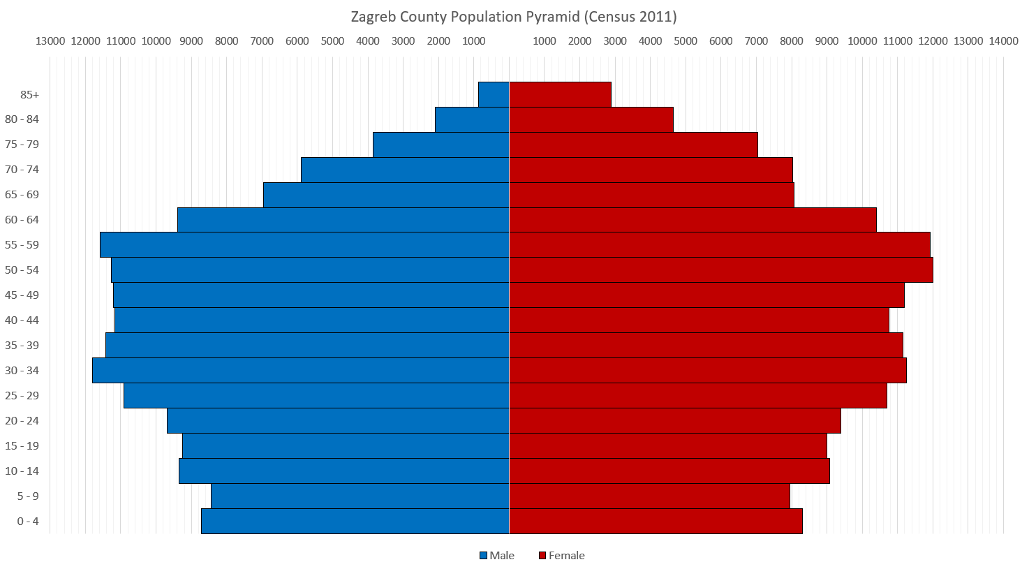
Demographics
References
References
- "O županiji - Zagrebačka županija".
- {{Croatia Yearbook 2015
- {{Croatian Census 2021. S. 01
- "Sub-national HDI - Area Database - Global Data Lab".
- ''[[Narodne novine]]'', br. 62/01, 125/08
- {{Croatian Census 2011. S. 01
- "2009 Elections - zagreb County, results".
This article was imported from Wikipedia and is available under the Creative Commons Attribution-ShareAlike 4.0 License. Content has been adapted to SurfDoc format. Original contributors can be found on the article history page.
Ask Mako anything about Zagreb County — get instant answers, deeper analysis, and related topics.
Research with MakoFree with your Surf account
Create a free account to save articles, ask Mako questions, and organize your research.
Sign up freeThis content may have been generated or modified by AI. CloudSurf Software LLC is not responsible for the accuracy, completeness, or reliability of AI-generated content. Always verify important information from primary sources.
Report