From Surf Wiki (app.surf) — the open knowledge base
Yasuf
| Field | Value |
|---|---|
| name | Yasuf |
| translit_lang1 | Arabic |
| translit_lang1_type | Arabic |
| translit_lang1_info | ياسوف |
| translit_lang1_type1 | Latin |
| translit_lang1_info1 | Yassuf (official) |
| Yasouf (unofficial) | |
| type | Municipality type D (Village council) |
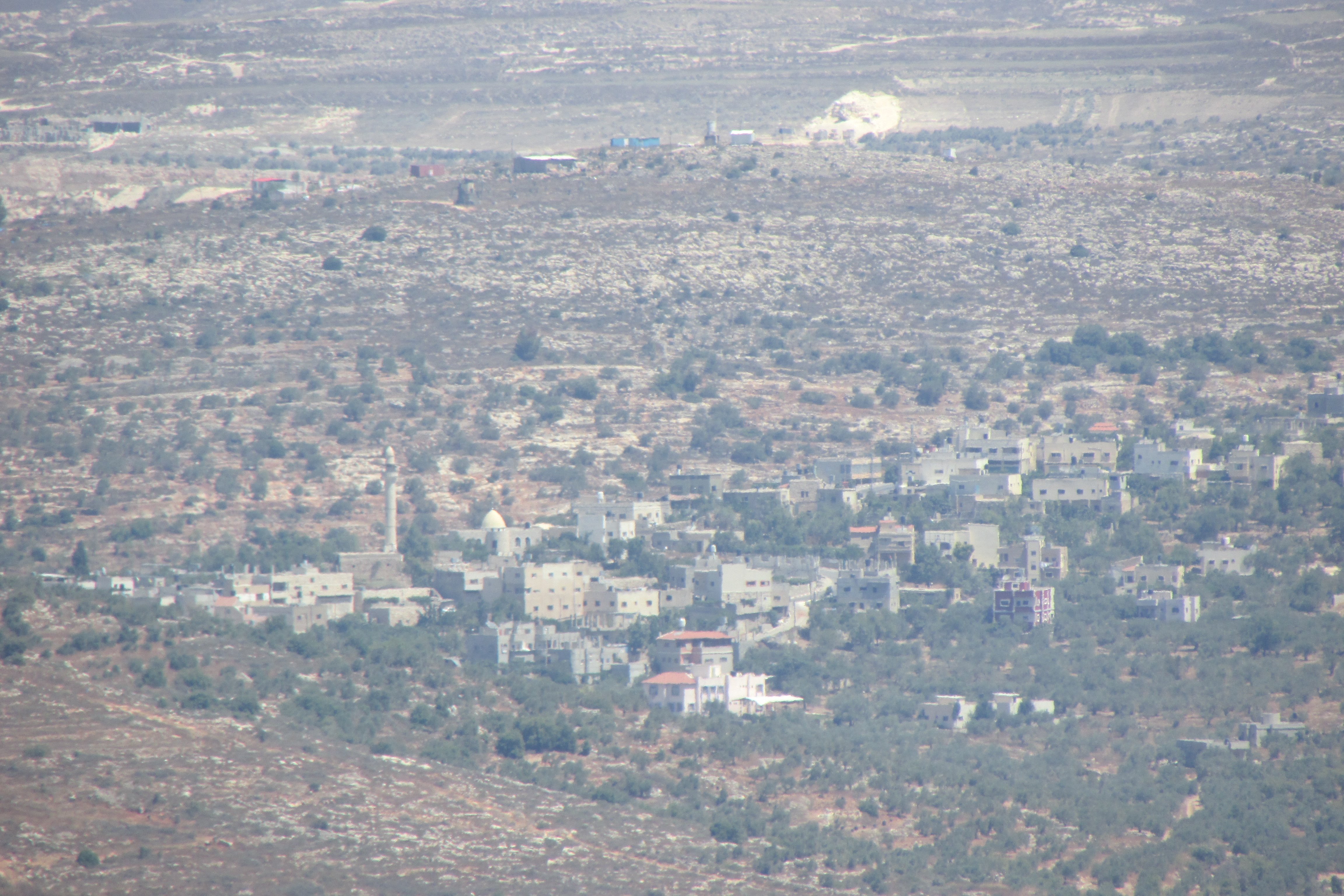
| image_skyline | כפר יאסוף.jpg |
| pushpin_map | Palestine |
| pushpin_map_caption | Location of Yasuf within Palestine |
| coordinates | |
| grid_name | Palestine grid |
| grid_position | 172/168 |
| subdivision_type | State |
| subdivision_name | State of Palestine |
| subdivision_type1 | Governorate |
| subdivision_name1 | Salfit |
| established_title | Founded |
| government_footnotes | tags -- |
| government_type | Village council |
| unit_pref | dunam |
| area_total_km2 | 8.6 |
| area_total_dunam | 8550 |
| elevation_footnotes | |
| elevation_m | 575 |
| population_footnotes | |
| population_total | 2093 |
| population_as_of | 2017 |
| population_density_km2 | auto |
| blank_name_sec1 | Name meaning |
| blank_info_sec1 | from personal name |
Yasouf (unofficial) Yasuf () is a Palestinian village in the Salfit Governorate of the State of Palestine, in the northern West Bank, northeast of Salfit, 37 km southwest of Nablus and adjacent to the Israeli settlement of Kfar Tapuach. According to the Palestinian Central Bureau of Statistics, it had a population of 2,093 in 2017. About 87% of the population relies on agriculture for income, while the remainder work in the public sector.
Location
Yasuf is 6 km north-east of Salfit. It is bordered by Yatma and Za'tara to the east, As-Sawiya to the east and south, Iskaka to the south and west, Jamma'in to the west and north, and Huwwara to the north.
History
Yasuf is an ancient village that is known from all periods. Potsherds from the Iron Age II (8th and 7th centuries BCE), have been found, and also from the Hellenistic/Roman, Crusader/Ayyubid, Mamluk and early Ottoman era. Byzantine ceramics have also been found.
NE and SW of the village is a large cemetery, with tombs carved into rock, some with arcosolia.
Iron age
Yasuf is identified with the Israelite village of Yaashuv mentioned in the Samaria Ostraca.
Classical antiquity
During the Roman period it was one of three important markets for fruits, grains and legumes in the northern Judean mountains, southern Samaria, and the region of Lod.
The village is mentioned by its current name in the Samaritan Book of Joshua, and in the "Samaritan Chronicle", its name is recorded as Jusepheh. According to the former, a story recounts how two Samaritan brothers, Ephraim and Menashe of Yasuf, hosted a Jewish pilgrim for the night and swapped the doves the pilgrim intended to offer as a sacrifice in the Temple of Jerusalem with mice. When their actions were discovered, they were punished and forced into servitude in the Temple. In a Samaritan text, the town was known to be inhabited by Samaritan High Priests.
Middle ages
During the Crusader period Diya' al-Din (1173–1245) writes that there was a rural mosque in Yasuf, indicating that there was a significant Muslim population in the village at the time. He also noted that followers of Ibn Qudamah lived here.
Yakut (1179–1229) noted that Yasuf was a "village of Nabulus in the Filastin province. It is celebrated for its abundance of pomegranates."
Ottoman period
The village was incorporated into the Ottoman Empire in 1517 with all of Palestine, and in 1596 it appeared in the tax registers under the name of Yasuf ar-Rumman. It was in the Nahiya of Jabal Qubal of the Liwa of Nablus, with a population of 41 households and 8 bachelors, all Muslim. The villagers paid taxes on wheat, barley, summer crops, olives, goats and beehives; a total of 6,700 akçe. 1,5/24 of the revenue went to a Waqf.
In the 18th and 19th centuries the village formed part of the highland region known as Jūrat ‘Amra or Bilād Jammā‘īn. Situated between Dayr Ghassāna in the south and the present Route 5 in the north, and between Majdal Yābā in the west and Jammā‘īn, Mardā and Kifl Ḥāris in the east, this area served, according to historian Roy Marom, "as a buffer zone between the political-economic-social units of the Jerusalem and the Nablus regions. On the political level, it suffered from instability due to the migration of the Bedouin tribes and the constant competition among local clans for the right to collect taxes on behalf of the Ottoman authorities."
French explorer Victor Guérin visited the village in 1870, and he found it to have about 350 inhabitants. The village appeared ancient, with old masonry reused in houses and walls. The village had an excellent supply of water which was collected in a pool, near the steps down was a beautifully carved niche with a shell motif. This pool provided water for gardens of olive and pomegranate trees.
In 1870/1871 (1288 AH) an Ottoman census listed the village in the nahiya (sub-district) of Jamma'in al-Thani, subordinate to Nablus.
In the 1882 PEF's Survey of Western Palestine (SWP), Yasuf is described as, "an ancient village," located in a valley, with a Roman road passing nearby. Inside the village is "a good spring ... and olives. A beautiful garden of pomegranates exists north of the spring. The water comes out of a cleft in a cliff, near which is an ancient well with steps. There is a sacred place, with a large oak (Sindian), and a ruined shrine, south-west of the village, near 'Ain er Raja. There are drafted stones in many houses, and remains of well-built enclosures, now ruined. Many well-cut rock tombs are also found on either side."
Also in the village were "rock-cut tombs with kokim [...]". A subterranean channel led out from the spring that contained small fish and there were pillar shafts there too. To the west of the village under an oak tree lay the ruins of a Maqam (shrine) for Sheikh Abu Hasan among the remains of other old drystone enclosures. To the north of the maqam was a rock-cut tomb, "with three loculi under arcosolia." Tombs also lay to the northeast and southwest with well-cut arched doors. In the valley to the northwest was a modern vault with a mihrab.
British Mandate period
In the 1922 census of Palestine conducted by the British Mandate authorities, Yasuf had a population of 172, all Muslims, while in the 1931 census it had 61 occupied houses and a population of 257, still all Muslim.
In the 1945 statistics the population was 360, all Muslims, while the total land area was 6,068 dunams, according to an official land and population survey. Of this, 928 were allocated for plantations and irrigable land, 1,991 for cereals, while 35 dunams were classified as built-up areas.
Jordanian period
In the wake of the 1948 Arab–Israeli War, and after the 1949 Armistice Agreements, Yasuf came under Jordanian rule.
The Jordanian census of 1961 found 585 inhabitants here.
1967–present
Main article: Israeli–Palestinian conflict
Since the Six-Day War in 1967, Yasuf has been under Israeli occupation.
After the 1995 accords, 25.5% of village land is defined as Area B land, while the remainder 74.5% is Area C. Israel has made numerous confiscations of village land, including confiscating 602 dunums for the establishment of the Israeli settlement of Kfar Tapuah.[[Image:Vandalized car in Yassuf 17Dec 2018.jpg |right|250px|thumb|"[[Price tag policy|Price tag]]" action on Dec 2018 in Yasuf, The Hebrew writing is "Jews wake up"]]On 11 December 2009, Yasuf's Al-Kabir Mosque was vandalized and burnt. Israeli police suspect the action was undertaken by Israeli settlers.
In January 2010 the extremist settler Rabbi Yitzhak Shapira was arrested by the Israeli police for alleged involvement in the torching of the mosque. He denied any involvement, and was later released due to lack of evidence.
In April 2010 the settlers spray-painted elsewhere in the village the words "Thank you God, for not making me a Gentile".
Israeli settler attacks
On October 6, 2014 Israeli settlers from Taffouh settlement ruined about 100 olive trees in Yasuf and 20 others in Burin, said Ghassan Daghlas, who is in charge of monitoring illegal settlers' activities in the area.
Tell Abu Zarad
Near Yasuf lies a significant archaeological tell known as Tell Abu Zarad. Positioned atop an dominating hill (PAL 171/167), it is home to a Muslim tomb-shrine dedicated to Sheikh Abu Zarad (or Abu az-Zurd). This location may be identified with a biblical named Tappuah, which is also associated with a place of the same name mentioned in a Qumran text. The majority of the potsherds found here date back to the Middle Bronze Age and Iron Age II.
References
Bibliography
References
- [http://vprofile.arij.org/salfit/pdfs/vprofile/Yasuf_vp_en.pdf Yasuf Village Profile], ARIJ, p. 4
- (February 2018). "Preliminary Results of the Population, Housing and Establishments Census, 2017". [[State of Palestine]].
- Palmer, 1881, p. [https://archive.org/stream/surveyofwesternp00conduoft#page/250/mode/1up 250]
- link. (2009-07-14 Land Research Center. 18 September 2008.)
- Grossman, D. (1986). "Oscillations in the Rural Settlement of Samaria and Judaea in the Ottoman Period". in '''Shomron studies'''. Dar, S., Safrai, S., (eds). Tel Aviv: Hakibbutz Hameuchad Publishing House. p. 354
- Finkelstein, 1997, p. 618
- Dauphin, 1998, p. 810
- ^ Bustanai Oded, History of the Jewish People in the time of First Temple – Volume 2, The Open University, p.' 262 (According to [[Yohanan Aharoni]]).
- Safrai, 1994, [https://books.google.com/books?id=i2-9ER6y1BAC&dq=yassuf&pg=PT77 p. 66].
- Conder and Kitchener, 1882, SWP II, p. [https://archive.org/stream/surveyofwesternp02conduoft#page/287/mode/1up 287]
- Conder, 1876, pp. [https://archive.org/stream/quarterlystateme07pale#page/190/mode/1up 190]-196
- Mor, Menahem. (2016). "The Second Jewish Revolt: the Bar Kokhba War, 132–136 CE". Brill.
- Conder, 1876, p. [https://archive.org/stream/quarterlystateme07pale#page/196/mode/1up 196]
- Ellenblum, 2003, p. [https://books.google.com/books?id=W08225mbAjAC&pg=PA244 244]
- Drory, 1988, p. 97
- Le Strange, 1890, p. [https://archive.org/stream/palestineundermo00lestuoft#page/552/mode/1up 552]
- Hütteroth and Abdulfattah, 1977, p. 134.
- Marom, Roy. (2022-11-01). "Jindās: A History of Lydda's Rural Hinterland in the 15th to the 20th Centuries CE". Lod, Lydda, Diospolis.
- Guérin, 1875, pp. [https://archive.org/stream/descriptiongogr04gugoog#page/n187/mode/1up 162]-3
- Grossman, David. (2004). "Arab Demography and Early Jewish Settlement in Palestine". Magnes Press.
- Conder and Kitchener, 1882, SWP II, p. [https://archive.org/stream/surveyofwesternp02conduoft#page/378/mode/1up 378].
- Barron, 1923, Table IX, Sub-district of Nablus, p. [https://archive.org/stream/PalestineCensus1922/Palestine%20Census%20%281922%29#page/n27/mode/1up 25]
- Mills, 1932, p. [https://archive.org/details/CensusOfPalestine1931.PopulationOfVillagesTownsAndAdministrativeAreas 66]
- Government of Palestine, Department of Statistics, 1945, p. [http://users.cecs.anu.edu.au/~bdm/yabber/census/VSpages/VS1945_p19.jpg 19]
- Government of Palestine, Department of Statistics. ''Village Statistics, April, 1945.'' Quoted in Hadawi, 1970, p. [http://www.palestineremembered.com/download/VillageStatistics/Table%20I/Nablus/Page-061.jpg 61]
- Government of Palestine, Department of Statistics. ''Village Statistics, April, 1945.'' Quoted in Hadawi, 1970, p. [http://www.palestineremembered.com/download/VillageStatistics/Table%20II/Nablus/Page-108.jpg 108]
- Government of Palestine, Department of Statistics. ''Village Statistics, April, 1945.'' Quoted in Hadawi, 1970, p. [http://www.palestineremembered.com/download/VillageStatistics/Table%20III/Nablus/Page-158.jpg 158]
- Government of Jordan, Department of Statistics, 1964, p. [http://users.cecs.anu.edu.au/~bdm/yabber/census/JordanCensusPages/JordanCensus1961-p26.pdf 26]
- [https://web.archive.org/web/20170804221215/http://vprofile.arij.org/salfit/pdfs/vprofile/Yasuf_vp_en.pdf Yasuf Village Profile], ARIJ, p. 16
- link. (2009-12-16 , Maan News, 11 December 2009.)
- Mark Weiss. (December 12, 2009). "Mosque fire leads to West Bank clash". The Irish Times.
- [https://news.bbc.co.uk/2/hi/middle_east/8482700.stm "Rabbi arrested, suspected in West Bank mosque arson"], BBC News, 27 January 2010
- [https://www.jpost.com/Israel/Article.aspx?id=175764 'IDF to blame for price-tag atmosphere'] ''Jerusalem Post''
- [https://www.haaretz.com/news/diplomacy-defense/palestinian-mosque-torched-in-suspected-price-tag-operation-by-settlers-1.317090 "Palestinian mosque torched in suspected 'price tag' operation by settlers."] by Avi Issacharoff. ''Haaretz''.
- [https://web.archive.org/web/20141009030031/http://english.wafa.ps/index.php?action=detail&id=26710 Extremist Settlers Ruin Olive Groves in Nablus Village] – [[WAFA]]
- Finkelstein, 1997, p. 606-607
This article was imported from Wikipedia and is available under the Creative Commons Attribution-ShareAlike 4.0 License. Content has been adapted to SurfDoc format. Original contributors can be found on the article history page.
Ask Mako anything about Yasuf — get instant answers, deeper analysis, and related topics.
Research with MakoFree with your Surf account
Create a free account to save articles, ask Mako questions, and organize your research.
Sign up freeThis content may have been generated or modified by AI. CloudSurf Software LLC is not responsible for the accuracy, completeness, or reliability of AI-generated content. Always verify important information from primary sources.
Report