From Surf Wiki (app.surf) — the open knowledge base
Yamanashi Prefecture
Prefecture of Japan

Prefecture of Japan
| Field | Value | |
|---|---|---|
| <!-- See Template:Infobox settlement for additional fields and descriptions --> | name | Yamanashi Prefecture |
| native_name | 山梨県 | |
| settlement_type | Prefecture | |
| translit_lang1 | Japanese | |
| translit_lang1_type | Japanese | |
| translit_lang1_info | 山梨県 | |
| translit_lang1_type1 | Rōmaji | |
| translit_lang1_info1 | Yamanashi-ken | |
| image_skyline | Lake Kawaguchiko Sakura Mount Fuji 3.JPG | |
| image_caption | Lake Kawaguchi, one of the Fuji Five Lakes in Yamanashi Prefecture, at the foot of Mount Fuji | |
| image_flag | Flag of Yamanashi Prefecture.svg | |
| flag_size | 100px | |
| image_blank_emblem | Symbol of Yamanashi Prefecture.svg | |
| blank_emblem_size | 80px | |
| blank_emblem_type | Symbol | |
| image_map | Map of Japan with highlight on 19 Yamanashi prefecture.svg | |
| subdivision_type | Country | |
| subdivision_name | Japan | |
| subdivision_type1 | Region | |
| subdivision_name1 | Chūbu (Kōshin'etsu) (Tōkai) | |
| subdivision_type2 | Island | |
| subdivision_name2 | Honshu | |
| seat_type | Capital | |
| seat | Kōfu | |
| parts_type | Subdivisions | |
| parts_style | para | |
| p1 | Districts: 5 | |
| p2 | Municipalities: 27 | |
| leader_title | Governor | |
| leader_name | Kotaro Nagasaki (from February 2019) | |
| area_total_km2 | 4,465.27 | |
| area_water_percent | 1.3 | |
| area_rank | 32nd | |
| elevation_max_m | 3778 | |
| elevation_max_point | Mount Fuji | |
| population_total | 787,592 | |
| population_as_of | February 1, 2025 | |
| population_rank | 41st | |
| population_density_km2 | 176 | |
| demographics_type2 | GDP | |
| demographics2_footnotes | ||
| demographics2_title1 | Total | |
| demographics2_info1 | JP¥ 3,566 billion | |
| US$ 32.7 billion (2019) | ||
| iso_code | JP-19 | |
| website | ||
| module | {{Infobox place symbols | embedded=yes |
| country | Japan | |
| bird | Uguisu (bush warbler) | |
| flower | Fujizakura (Fuji cherry) | |
| tree | Kaede (Japanese maple) | |
| population_blank1_title | Dialects | |
| population_blank1 | Gun'nai・Koshu・Narada | |
| anthem | Yamanashi-ken no uta |
US$ 32.7 billion (2019)
Yamanashi Prefecture is a prefecture of Japan located in the Chūbu region of Honshu. Yamanashi Prefecture has a population of 787,592 (1 February 2025) and has a geographic area of 4,465 km2 (1,724 sq mi). Yamanashi Prefecture borders Saitama Prefecture to the northeast, Nagano Prefecture to the northwest, Shizuoka Prefecture to the southwest, Kanagawa Prefecture to the southeast, and Tokyo to the east.
Kōfu is the capital and largest city of Yamanashi Prefecture, with other major cities including Kai, Minamiarupusu, and Fuefuki. Yamanashi Prefecture is one of only eight landlocked prefectures, and the majority of the population lives in the central Kōfu Basin surrounded by the Akaishi Mountains, with 27% of its total land area being designated as Natural Parks. Yamanashi Prefecture is home to many of the highest mountains in Japan, and Mount Fuji, the tallest mountain in Japan and cultural icon of the country, is partially located in Yamanashi Prefecture on the border with Shizuoka Prefecture.
Etymology
The name Yamanashi Prefecture literally means Pear Mountain. Nashi specifically refers to a local Japanese cultivar of the Asian pear, Pyrus pyrifolia.
History
Pre-history to the 14th century
As in most other Japanese regions, prehistoric society in Yamanashi progressed through the hunting, fishing and gathering stage of the Jōmon period, then the rice-producing stage of the Yayoi period and subsequent village and regional formation. The Maruyama and Choshizuka Kofun (earthen burial mounds) located on Sone Hill of Nakamichi Town (Southern Kōfu) are believed to have been built from the end of the 4th century. From these remains it can be assumed that the people of Sone Hill had great influence.
During the Heian period, Kai Province was created in this area.
15th to 19th centuries
Among the many Kaigenji generations, those of the Takeda, Ogasawara, and Nanbu families were particularly prosperous. During the Sengoku period of the 16th century, Takeda Shingen attained the status of daimyō and built Tsuzuji Mansion and the Yōgai Castle in Kōfu. From this base, he attempted to unify and control Japan.
After Takeda's death in 1582, Kai-no-Kuni came under the control of the Oda and Toyotomi clans before being subsumed into the Tokugawa shogunate during the Edo period. Beneath the Edo shogunate, the Kōfu clan (based in Kuninaka, or Central and Western Yamanashi) and the Yamura clan (based in Gunnai, or Eastern Yamanashi) were formed, but in 1724 the area came under the direct control of the Shogunate. With the development of the Kōshū Kaidō (highway) and Fuji River transport, goods, materials and culture flowed into the region.
By the mid-19th century, the contradictions of military government and clan system caused stability to erode and resistance to erupt across Japan, paving the way for the Meiji Restoration of 1868.
Meiji Restoration (1868) to end of World War II (1945)

During the Boshin War, the Battle of Kōshū-Katsunuma on the 29 March 1868 was a significant battle between pro-Imperial and Tokugawa shogunate forces immediately prior to the Imperial Forces march on Edo Castle. Preceding the Kōshū-Katsunuma battle, Kōfu Castle had been captured by troops loyal to the Emperor Meiji.
The province was renamed Kōfu Prefecture in 1869 and then Yamanashi Prefecture in 1871. The anniversary of this event on November 20, 1872, is now celebrated as Prefectural Citizen's Day in Yamanashi.
In the early part of the Meiji period (1868–1911), industrial promotion policies furthered sericulture, silk textile production and wine making industries. In 1903, after seven years of construction, including the building of a nearly three mile long tunnel at the Sasago Pass, the Chūō Railway Line from Hachiōji and central Tokyo finally reached Kōfu. The reduced journey times to the capital and the port of Yokohama brought significant change to local industry and culture.
Agricultural production in farming communities was still on a small scale at the turn of the century and land reforms had yet to be introduced. From the 1920s however, tenancy and contract disputes between landowners and farmers in Yamanashi grew increasingly common.
In 1926, the Minobu Railway Line connecting Kōfu with Shizuoka Prefecture opened, bringing an end to Fuji River transportation. The Koumi Line connecting Kobuchizawa to Kiyosato was opened by Japanese National Railways (JNR) in 1933, providing access to hitherto remote highland areas on the slopes of Mt. Yatsugatake in the North of the prefecture.
1945 to present
Small scale manufacturing industries and commerce grew at rapid speed during the expansion of the post-war Japanese economy. The 1982 opening of the Chūō Expressway also led to significant growth in service industries, transport logistics and tourism.
In common with many similar sized cities during the 1990s, rapid growth in car ownership, out of town shopping, and improved transportation links to Tokyo, caused a drop in commercial activity and land values in the center of the prefectural capital Kōfu. To counterbalance this trend the prefectural government launched a city center revitalization plan in 2008, promoting downtown tourist attractions such as redeveloped land North of Kōfu station, Maizuru Castle Park and new residential, cultural and government office facilities.
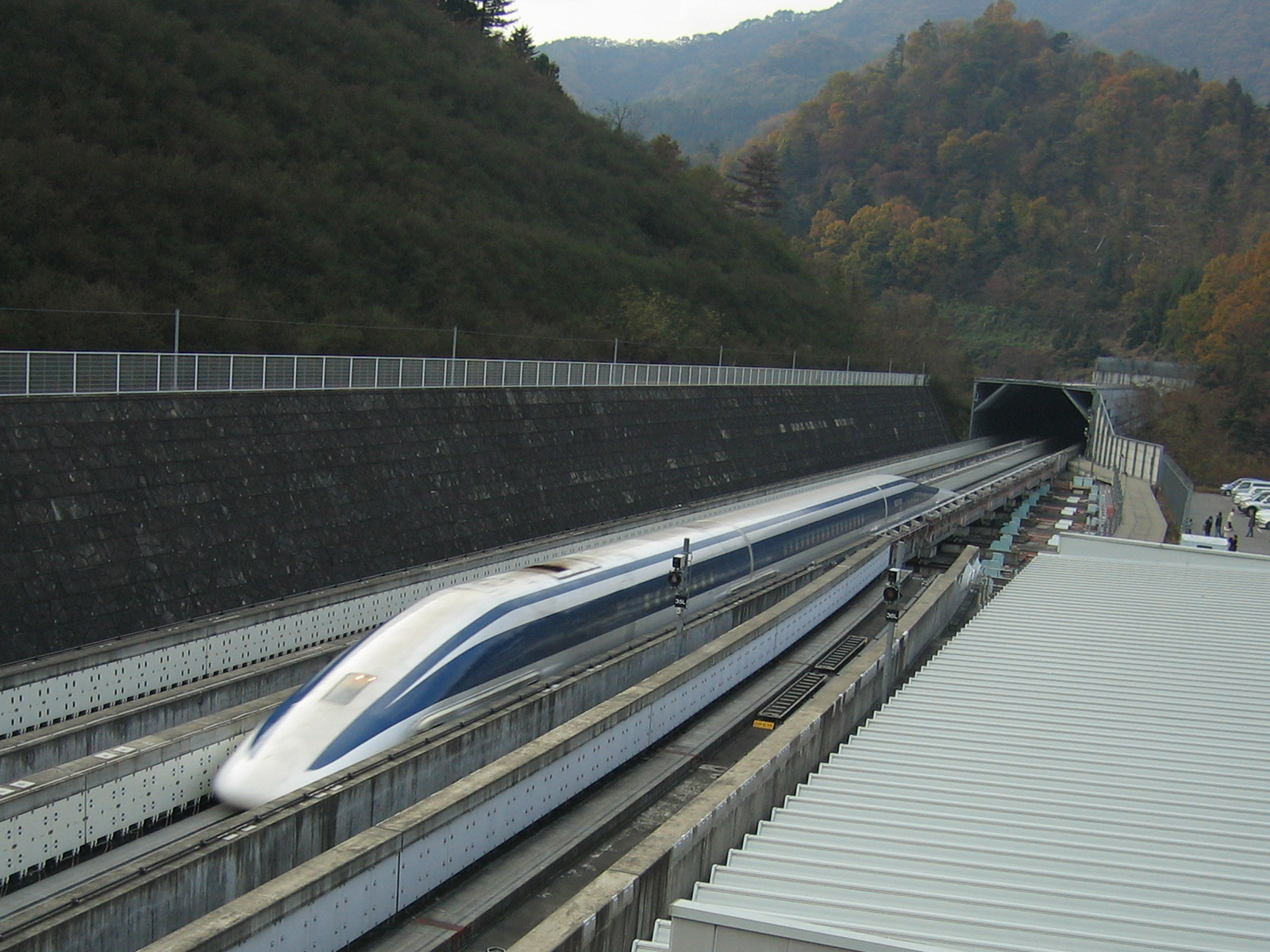
The maglev line is designed to ultimately connect Tokyo, Nagoya, and Osaka with a station also planned to the South of Kōfu.
Central Government permission to proceed with an extension to the existing test track was granted on May 27, 2011. At the end of 2013 construction was already well advanced as far as Fuefuki.
JR Central is considering opening a demonstration service from a new station in Kōfu by the 2020 Summer Olympics so that visitors can also ride on the experimental track through the Yamanashi mountains.
Geography
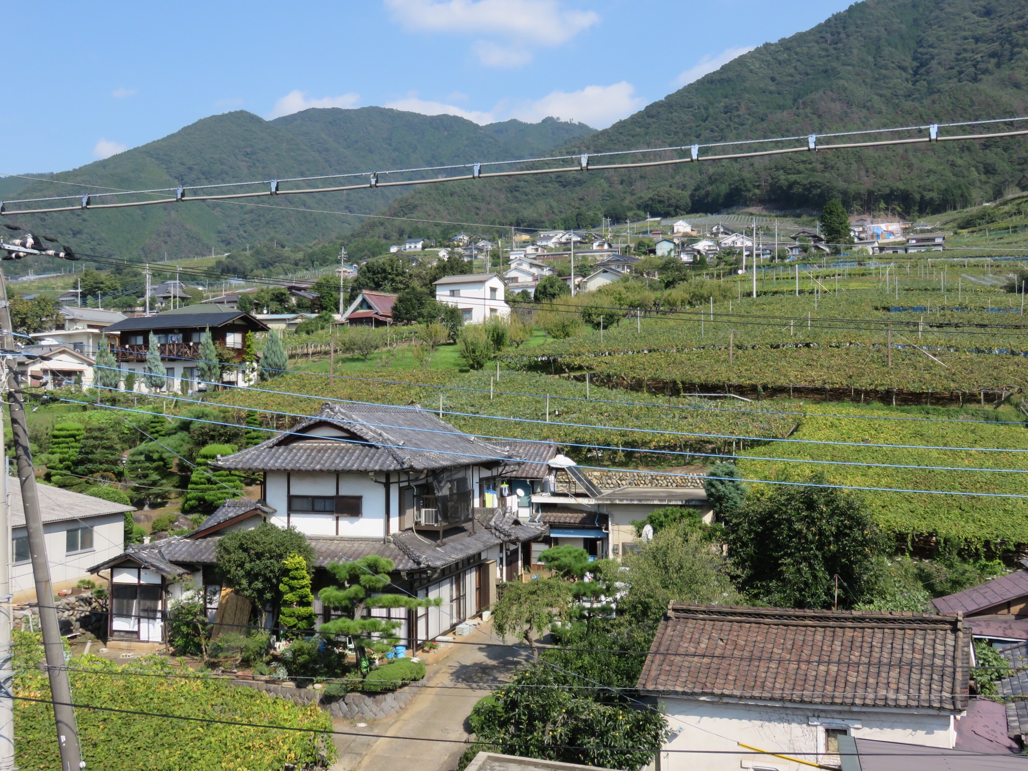
Yamanashi Prefecture is bordered by Tokyo, Kanagawa Prefecture, Saitama Prefecture, Shizuoka Prefecture, and Nagano Prefecture. The prefecture is landlocked, with high mountains surrounding the central Kōfu Basin. Mount Fuji and the Fuji Five Lakes region is located on the southern border with Shizuoka. Mount Fuji provides rain shadow effects, and as a result, the prefecture receives only about 818 mm of rainfall a year.


As of April 1, 2012, 27% of the total land area of the prefecture was designated as Natural Parks, namely the Chichibu Tama Kai, Fuji-Hakone-Izu, and Minami Alps National Parks; Yatsugatake-Chūshin Kōgen Quasi-National Park; and Minami Alps Koma and Shibireko Prefectural Natural Parks.
78% of the prefecture is covered by forests, making it one of the most densely wooded prefectures in Japan. Land cultivated for agriculture is mainly restricted to the lower elevations of the Kōfu basin.
Cities
Thirteen cities are located in Yamanashi Prefecture:
| Name | Area (km2) | Population | Map | Rōmaji | Kanji | ||||
|---|---|---|---|---|---|---|---|---|---|
| [[File:Flag of Chuo Yamanashi.svg | frameless | 25x25px]] Chūō | 中央市 | 31.69 | 30,835 | [[File:Chuo in Yamanashi Prefecture Ja.svg | frameless | 52x52px]] | |
| [[File:Flag of Fuefuki, Yamanashi (no text).svg | frameless | 25x25px]] Fuefuki | 笛吹市 | 201.92 | 69,463 | [[File:Fuefuki in Yamanashi Prefecture Ja.svg | frameless | 52x52px]] | |
| [[File:Flag of Fujiyoshida, Yamanashi.svg | frameless | 25x25px]] Fujiyoshida | 富士吉田市 | 121.74 | 48,782 | [[File:Fujiyoshida in Yamanashi Prefecture Ja.svg | frameless | 52x52px]] | |
| [[File:Flag of Hokuto, Yamanashi.svg | frameless | 25x25px]] Hokuto | 北杜市 | 602.48 | 46,888 | [[File:Hokuto in Yamanashi Prefecture Ja.svg | frameless | 52x52px]] | |
| [[File:Flag of Kai, Yamanashi.svg | frameless | 25x25px]] Kai | 甲斐市 | 71.95 | 75,706 | [[File:Kai in Yamanashi Prefecture Ja.svg | frameless | 52x52px]] | |
| [[File:Flag of Kofu, Yamanashi.svg | frameless | 25x25px]] Kōfu (capital) | 甲府市 | 212.47 | 187,985 | [[File:Kofu in Yamanashi Prefecture Ja.svg | frameless | 52x52px]] | |
| [[File:Flag of Koshu, Yamanashi.svg | frameless | 25x25px]] Kōshū | 甲州市 | 264.11 | 31,526 | [[File:Koshu in Yamanashi Prefecture Ja.svg | frameless | 52x52px]] | |
| [[File:Flag of Minami-Alps, Yamanashi.svg | frameless | 25x25px]] Minami-Alps | 南アルプス市 | 264.14 | 71,618 | [[File:Minami-alps in Yamanashi Prefecture Ja.svg | frameless | 52x52px]] | |
| [[File:Flag of Nirasaki, Yamanashi.svg | frameless | 25x25px]] Nirasaki | 韮崎市 | 143.69 | 29,483 | [[File:Nirasaki in Yamanashi Prefecture Ja.svg | frameless | 52x52px]] | |
| [[File:Flag of Otsuki, Yamanashi.svg | frameless | 25x25px]] Ōtsuki | 大月市 | 280.25 | 23,976 | [[File:Otsuki in Yamanashi Prefecture Ja.svg | frameless | 52x52px]] | |
| [[File:Flag of Tsuru, Yamanashi.svg | frameless | 25x25px]] Tsuru | 都留市 | 161.63 | 30,311 | [[File:Tsuru in Yamanashi Prefecture Ja.svg | frameless | 52x52px]] | |
| [[File:Flag of Uenohara, Yamanashi.svg | frameless | 25x25px]] Uenohara | 上野原市 | 170.57 | 23,158 | [[File:Uenohara in Yamanashi Prefecture Ja.svg | frameless | 52x52px]] | |
| [[File:Flag of Yamanashi, Yamanashi.svg | frameless | 25x25px]] Yamanashi | 山梨市 | 289.8 | 34,738 | [[File:Yamanashi in Yamanashi Prefecture Ja.svg | frameless | 52x52px]] |
Towns and villages
These are the towns and villages in each district:
| Name | Area (km2) | Population | District | Type | Map | Rōmaji | Kanji | ||||
|---|---|---|---|---|---|---|---|---|---|---|---|
| [[File:Flag of Doshi, Yamanashi.svg | frameless | 25x25px]] Dōshi | 道志村 | 79.57 | 1,676 | Minamitsuru District | Village | [[File:Doshi in Yamanashi Prefecture Ja.svg | frameless | 52x52px]] | |
| [[File:Flag of Fujikawa, Yamanashi.svg | frameless | 25x25px]] Fujikawa | 富士川町 | 111.98 | 15,125 | Minamikoma District | Town | [[File:Fujikawa in Yamanashi Prefecture Ja.svg | frameless | 52x52px]] | |
| [[File:Flag of Fujikawaguchiko, Yamanashi.svg | frameless | 25x25px]] Fujikawaguchiko | 富士河口湖町 | 158.4 | 26,540 | Minamitsuru District | Town | [[File:Fujikawaguchiko in Yamanashi Prefecture Ja.svg | frameless | 56x56px]] | |
| [[File:Flag of Hayakawa, Yamanashi.svg | frameless | 25x25px]] Hayakawa | 早川町 | 369.86 | 994 | Minamikoma District | Town | [[File:Hayakawa in Yamanashi Prefecture Ja.svg | frameless | 52x52px]] | |
| [[File:Flag of Ichikawamisato, Yamanashi.svg | frameless | 25x25px]] Ichikawamisato | 市川三郷町 | 75.18 | 15,799 | Nishiyatsushiro District | Town | [[File:Ichikawamisato in Yamanashi Prefecture Ja.svg | frameless | 52x52px]] | |
| [[File:Flag of Kosuge, Yamanashi.svg | frameless | 25x25px]] Kosuge | 小菅村 | 52.78 | 701 | Kitatsuru District | Village | [[File:Kosuge in Yamanashi Prefecture Ja.svg | frameless | 52x52px]] | |
| [[File:Flag of Minobu, Yananashi.svg | frameless | 25x25px]] Minobu | 身延町 | 302 | 11,674 | Minamikoma District | Town | [[File:Minobu in Yamanashi Prefecture Ja.svg | frameless | 52x52px]] | |
| [[File:Flag of Nanbu, Yamanashi.svg | frameless | 25x25px]] Nanbu | 南部町 | 200.63 | 7,222 | Minamikoma District | Town | [[File:Nanbu in Yamanashi Prefecture Ja.svg | frameless | 52x52px]] | |
| [[File:Flag of Narusawa, Yamanashi.svg | frameless | 25x25px]] Narusawa | 鳴沢村 | 89.58 | 3,152 | Minamitsuru District | Village | [[File:Narusawa in Yamanashi Prefecture Ja.svg | frameless | 52x52px]] | |
| [[File:Flag of Nishikatsura, Yamanashi (no text).svg | frameless | 25x25px]] Nishikatsura | 西桂町 | 15.22 | 4,298 | Minamitsuru District | Town | [[File:Nishikatsura in Yamanashi Prefecture Ja.svg | frameless | 52x52px]] | |
| [[File:Flag of Oshino, Yamanashi.svg | frameless | 25x25px]] Oshino | 忍野村 | 25.05 | 9,710 | Minamitsuru District | Village | [[File:Oshino in Yamanashi Prefecture Ja.svg | frameless | 52x52px]] | |
| [[File:Flag of Showa, Yamanashi.svg | frameless | 25x25px]] Shōwa | 昭和町 | 9.08 | 20,338 | Nakakoma District | Town | [[File:Showa in Yamanashi Prefecture Ja.svg | frameless | 52x52px]] | |
| [[File:Flag of Tabayama, Yamanashi.svg | frameless | 25x25px]] Tabayama | 丹波山村 | 101.3 | 529 | Kitatsuru District | Village | [[File:Tabayama in Yamanashi Prefecture Ja.svg | frameless | 52x52px]] | |
| [[File:Flag of Yamanakako Yamanashi.svg | frameless | 25x25px]] Yamanakako | 山中湖村 | 52.81 | 5,826 | Minamitsuru District | Village | [[File:Yamanakako in Yamanashi Prefecture Ja.svg | frameless | 52x52px]] |
Mergers
Main article: List of mergers in Yamanashi Prefecture
List of governors of Yamanashi Prefecture
| Name | Start | End |
|---|---|---|
| Katsuyasu Yoshie (吉江勝保) | 12 April 1947 | 29 April 1951 |
| Hisashi Amano (天野久) | 30 April 1951 | 16 February 1967 |
| Kunio Tanabe (田辺国男) | 17 February 1967 | 16 February 1979 |
| Komei Mochizuki (望月幸明) | 17 February 1979 | 16 February 1991 |
| Ken Amano (天野建) | 17 February 1991 | 16 February 2003 |
| Takahiko Yamamoto (山本栄彦) | 17 February 2003 | 16 February 2007 |
| Shōmei Yokouchi (横内 正明) | 17 February 2007 | 16 February 2015 |
| Hitoshi Goto (後藤 斎) | 17 February 2015 | 16 February 2019 |
| Kotaro Nagasaki (長崎幸太郎) | 17 February 2019 | Present |
Economy
Yamanashi has a sizable industrial base in and around Kōfu city, with jewelry and robotics industries being particularly prominent. The headquarters of FANUC, manufacturer of factory automation systems, is based in Oshino in the south of the prefecture.
The prefecture is also host to numerous fruit farms and vineyards. Yamanashi is one of the major fruit producing regions in Japan, being the top domestic producer of grapes, peaches, plums as well as wine.
In addition, roughly 40% of the mineral water bottled in Japan comes from Yamanashi, mainly from around the Southern Alps, Mount Fuji, and Mitsutōge areas. The quality of the water sources in the Southern Alps prompted Suntory Group to open the Hakushu distillery in the northern Yamanashi town of Hokuto.
Population

Per Japanese census data, Yamanashi prefecture had negative population growth from 1950 to 1970 and again in the 21st century, with the population peaking at roughly 890,000 around the turn of the millennium.
Tourism


The natural scenery and cultural sights of Yamanashi are popular destinations for both domestic and international tourists due to the prefecture's proximity to the crowded Tokyo conurbation and ease of access by road and rail. Mount Fuji, the Fuji Five Lakes region, the highland resort region of Kiyosato, the city of Kōfu, the Senga Falls, Koshu wineries, the temple of Erin-ji in Koshu, and the Kuonji Temple at Minobu are a few of the most popular places to visit.
The Fuji-Q Highland amusement park at Fujiyoshida with roller coasters Eejanaika, and Takabisha, the world's steepest roller coaster, is also a popular destination for day trips.
The natural topography of the region makes Yamanashi popular with mountaineering, hiking and climbing enthusiasts throughout the year. The highest mountain in Japan, Mount Fuji, at 3776 m and the second highest mountain in Japan, Mount Kita, at 3193 m are both located within Yamanashi. The Mt. Fuji summer hiking season in July and August attracts thousands of overnight hikers typically starting at the Fifth Station in the late evening and climbing through the night to witness the sunrise at the summit.
Although not as tall, Mount Minobu, a popular place for Buddhist pilgrimage, offers extensive views from the summit of the mountain. Parts of the Fuji-Hakone-Izu National Park, Chichibu-Tama-Kai National Park, and Minami Alps National Park are all located in Yamanashi.
Given the area's volcanic activity, natural hot springs, or onsens, are found in abundance. Some of the more well known are Shimobe Onsen, Isawa Onsen and Yamanami Onsen.
The mascot of the prefecture is Hishimaru (菱丸), a Kai Ken dog who is based on the local Sengoku-era daimyō Takeda Shingen. He wears a kabuto with the crest of the Takeda clan.
Major festivals

- Shingen festival, held each March in the precincts of Kōfu Castle and Takeda Shrine in commemoration of Takeda Shingen's role in prefectural history.
- Fujiyoshida fire festival, marks the end of the summer climbing season on Mount Fuji. Held on the last weekend in August.
- Yatsugatake county fair and Paul Rusch festival. Held each October in Kiyosato to celebrate the life and work of Paul Rusch, his contributions to local agricultural development and US Japan friendship.
Universities
- Tsuru University
- University of Yamanashi
- Yamanashi Eiwa College
- Yamanashi Gakuin University
- Yamanashi Prefectural University
Sports

Ventforet Kōfu, the J2 League association football (soccer) team is based in Kōfu. The team's home ground is the Yamanashi Chuo Bank Stadium.
Since 2005 the Fujizakura Country Club in Fujikawaguchiko has also hosted the Fujisankei Classic golf tournament, an annual event on the Japan Golf Tour.
Transportation


Railway lines
- Central Japan Railway Company
- Minobu Line
- Chūō Shinkansen(Under construction)
- East Japan Railway Company
- Chūō Main Line
- Koumi Line
- Fuji Kyuko
- Fujikyuko Line
Road
Expressways
- Chūbu-Ōdan Expressway (under construction)
- Chuo Expressway
- Higashifuji-goko Road
- Kōfu Yamanashi Road
National highways
- Route 20
- Route 52
- Route 137
- Route 138
- Route 139
- Route 140
- Route 141
- Route 411
- Route 413
- Route 469
Media
Television
- UHF Television Yamanashi (UTY)
- Yamanashi Broadcasting System (YBS)
Radio
- FM Fuji (FMF)
International relations
- KOR Chungcheongbuk-do, Korea, since 1992
- USA Fairfield, California, United States, since the 1970s
- USA Iowa, United States, since 1960
- USA Madison County, Kentucky, United States, since 1988
- BRA Minas Gerais, Brazil, since 1973
- FRA Saône-et-Loire, France, since 2000
- CHN Sichuan Province, China, since 1985
Notes
References
- Nussbaum, Louis-Frédéric and Käthe Roth. (2005). Japan encyclopedia. Cambridge: Harvard University Press. ; OCLC 58053128
References
- "2020年度国民経済計算(2015年基準・2008SNA) : 経済社会総合研究所 - 内閣府".
- NHK Publishing. (24 May 2016)
- Nussbaum, Louis-Frédéric. (2005). "Yamanashi-ken" in {{Google books. p2QnPijAEmEC. ''Japan Encyclopedia'', p. 1044. p2QnPijAEmEC. p. 126
- [http://www.city.kofu.yamanashi.jp/contents/ 甲府市]; [http://www.city.kofu.yamanashi.jp/english/intro/intro.htm Introduction of Kofu City] {{Webarchive. link. (2012-03-27 ; retrieved 2011-07-13)
- "Pyrus pyrifolia var. culta - Nashi Tree {{!}} FLORA TOSKANA".
- Nussbaum, "Provinces and prefectures" at {{Google books. p2QnPijAEmEC. p. 780
- (1996). "The Sound of the Whistle: Railroads and the State in Meiji Japan". Harvard University Press.
- (1986). "Agricultural Development and Tenancy Disputes in Japan, 1870-1940". Princeton University Press.
- (1991). "Paul Rusch". Forward Movement Publications.
- (December 8, 2002). "There's cows in them there hills". Japan Times.
- "中央新幹線(東京都・名古屋市間)計画段階環境配慮書の公表について". [[Central Japan Railway Company]].
- (14 January 2014). "リニア山梨県駅、東京五輪前に 体験乗車に道 JR東海が検討". 日本経済新聞.
- "General overview of area figures for Natural Parks by prefecture". [[Ministry of the Environment (Japan).
- "2008 Yamanashi Ken no Aramashi". Yamanashi Prefectural Government.
- "FANUC History". FANUC Europe Corporation.
- "Statistics Bureau Home Page".
- (2023-04-13). "Yamanashi Prefecture".
This article was imported from Wikipedia and is available under the Creative Commons Attribution-ShareAlike 4.0 License. Content has been adapted to SurfDoc format. Original contributors can be found on the article history page.
Ask Mako anything about Yamanashi Prefecture — get instant answers, deeper analysis, and related topics.
Research with MakoFree with your Surf account
Create a free account to save articles, ask Mako questions, and organize your research.
Sign up freeThis content may have been generated or modified by AI. CloudSurf Software LLC is not responsible for the accuracy, completeness, or reliability of AI-generated content. Always verify important information from primary sources.
Report