From Surf Wiki (app.surf) — the open knowledge base
Yamagata Prefecture
Prefecture of Japan

Prefecture of Japan
| Field | Value | |
|---|---|---|
| <!-- See Template:Infobox settlement for additional fields and descriptions --> | name | Yamagata Prefecture |
| native_name | 山形県 | |
| settlement_type | Prefecture | |
| translit_lang1 | Japanese | |
| translit_lang1_type | Japanese | |
| translit_lang1_info | 山形県 | |
| translit_lang1_type1 | Rōmaji | |
| translit_lang1_info1 | Yamagata-ken | |
| image_skyline | {{Multiple image | |
| border | infobox | |
| total_width | 290 | |
| image_style | border:1; | |
| perrow | 1/2/2 | |
| image1 | Evening twilight in Ginzan Onsen town January 2022 A.jpg | |
| caption1 | Ginzan Onsen | |
| image2 | Risshaku-ji Kaisan-do 201706b.jpg | |
| caption2 | Yama-dera | |
| image3 | Zao snow monsters.jpg | |
| caption3 | Snow monsters of Mount Zaō | |
| image4 | Five tier pagoda at Mt. Haguro 2006-10-29.jpg | |
| caption4 | Mount Haguro | |
| image5 | Kamo Aquarium Water tank.jpg | |
| caption5 | Kamo Aquarium | |
| image_flag | Flag of Yamagata Prefecture.svg | |
| flag_size | 100px | |
| image_blank_emblem | Emblem of Yamagata Prefecture.svg | |
| blank_emblem_size | 80px | |
| blank_emblem_type | Symbol | |
| image_map | Map of Japan with highlight on 06 Yamagata_prefecture.svg | |
| subdivision_type | Country | |
| subdivision_name | Japan | |
| subdivision_type1 | Region | |
| subdivision_name1 | Tōhoku | |
| subdivision_type2 | Island | |
| subdivision_name2 | Honshu | |
| seat_type | Capital | |
| seat | Yamagata | |
| parts_type | Subdivisions | |
| parts_style | para | |
| p1 | Districts: 8 | |
| p2 | Municipalities: 35 | |
| leader_title | Governor | |
| leader_name | Mieko Yoshimura | |
| area_total_km2 | 9325.15 | |
| area_water_percent | 0.02 | |
| area_rank | 9th | |
| population_total | 999378 | |
| population_as_of | May 1, 2025 | |
| population_rank | 35th | |
| population_density_km2 | auto | |
| demographics_type2 | GDP | |
| demographics2_footnotes | ||
| demographics2_title1 | Total | |
| demographics2_info1 | JP¥ 4,337 billion | |
| US$ 39.8 billion (2019) | ||
| iso_code | JP-06 | |
| website | ||
| module | {{Infobox place symbols | embedded=yes |
| country | Japan | |
| bird | Mandarin duck (Aix galericulata) | |
| fish | Cherry salmon (Oncorhynchus masou) | |
| flower | Safflower (Carthamus tinctorius) | |
| tree | Cherry | |
| population_blank1_title | Dialects | |
| population_blank1 | Nairiku・Shōnai | |
| anthem | Mogami gawa |
US$ 39.8 billion (2019)
Yamagata Prefecture is a prefecture of Japan located in the Tōhoku region of Honshu. It has a population of 1,005,926 (1 February 2025) and an area of 9,325 km2 (3,600 sq mi). Its neighbours are Akita Prefecture to the north, Miyagi Prefecture to the east, Fukushima Prefecture to the south, and Niigata Prefecture to the southwest.
The capital and largest city is Yamagata, with other major cities being Tsuruoka, Sakata and Yonezawa. The prefecture is located on Japan's western Sea of Japan coast and its borders with neighboring prefectures are formed by various mountain ranges, with 17% of its total land area being designated as Natural Parks. Yamagata Prefecture formed the southern half of the historic Dewa Province with Akita Prefecture and is home to the Three Mountains of Dewa, which includes the Haguro Five-story Pagoda, a recognised National Treasure of Japan.
History
The aboriginal Ezo people once inhabited the area now known as Yamagata. Yamagata and Akita Prefecture were known as Dewa Province until the Meiji Restoration.
During the Heian period (794–1185), the Fujiwara family ruled the area. Yamagata City flourished during the Edo period (1603–1867) due to its status as a castle town and post station, famous for* beni* (red safflower dye used in the production of handspun silk). In 1689, the famous haiku poet, Matsuo Bashō visited Yamagata during his five-month trip to the northern regions of Japan.
Geography

Yamagata Prefecture is located in the southwest corner of Tōhoku, facing the Sea of Japan. It borders Niigata Prefecture and Fukushima Prefecture on the south, Miyagi Prefecture on the east, and Akita Prefecture on the north. All of these boundaries are marked by mountains, with most of the population residing in a limited central plain.
As of 31 March 2020, 17 percent of the total land area of the prefecture was designated as Natural Parks, namely the Bandai-Asahi National Park; Chōkai, Kurikoma, and Zaō Quasi-National Parks; and Goshōzan, Kabusan, Kennan, Mogamigawa, Shōnai Kaihin, and Tendō Kōgen Prefectural Natural Parks.
Cities
Thirteen cities are located in Yamagata Prefecture:
| Name | Area (km2) | Population | Population density (per km2) | Map | Rōmaji | Kanji | ||||
|---|---|---|---|---|---|---|---|---|---|---|
| [[File:Flag of Higashine Yamagata.svg | frameless | 25x25px]] Higashine | 東根市 | 207.17 | 47,910 | 231.26 | [[File:Higashine in Yamagata Prefecture Ja.svg | frameless | 90x90px]] | |
| [[File:Flag of Kaminoyama Yamagata.svg | frameless | 25x25px]] Kaminoyama | 上山市 | 240.93 | 29,974 | 124.41 | [[File:Kaminoyama in Yamagata Prefecture Ja.svg | 90x90px]] | ||
| [[File:Flag of Murayama, Yamagata.svg | frameless | 25x25px]] Murayama | 村山市 | 196.98 | 23,643 | 120.03 | [[File:Murayama in Yamagata Prefecture Ja.svg | frameless | 90x90px]] | |
| [[File:Flag of Nagai, Yamagata.svg | frameless | 25x25px]] Nagai | 長井市 | 214.67 | 26,466 | 123.29 | [[File:Nagai in Yamagata Prefecture Ja.svg | frameless | 90x90px]] | |
| [[File:Flag of Nanyo, Yamagata.svg | frameless | 25x25px]] Nan'yō | 南陽市 | 160.52 | 31,112 | 193.82 | [[File:Nanyo in Yamagata Prefecture Ja.svg | frameless | 90x90px]] | |
| [[File:Flag of Obanazawa Yamagata.svg | frameless | 25x25px]] Obanazawa | 尾花沢市 | 373.32 | 15,237 | 40.81 | [[File:Obanazawa in Yamagata Prefecture Ja.svg | frameless | 90x90px]] | |
| [[File:Flag of Sagae, Yamagata.svg | frameless | 25x25px]] Sagae | 寒河江市 | 139.03 | 40,131 | 288.65 | [[File:Sagae in Yamagata Prefecture Ja.svg | frameless | 90x90px]] | |
| [[File:Flag of Sakata, Yamagata.svg | frameless | 25x25px]] Sakata | 酒田市 | 602.97 | 99,341 | 164.75 | [[File:Sakata in Yamagata Prefecture Ja.svg | frameless | 90x90px]] | |
| [[File:Flag of Shinjō, Yamagata.svg | frameless | 25x25px]] Shinjō | 新庄市 | 223.08 | 34,937 | 156.61 | [[File:Shinjo in Yamagata Prefecture Ja.svg | frameless | 90x90px]] | |
| [[File:Flag of Tendo Yamagata.svg | frameless | 25x25px]] Tendō | 天童市 | 113.01 | 61,947 | 548.16 | [[File:Tendo in Yamagata Prefecture Ja.svg | frameless | 90x90px]] | |
| [[File:Flag of Tsuruoka, Yamagata.svg | frameless | 25x25px]] Tsuruoka | 鶴岡市 | 1,311.53 | 125,389 | 95.61 | [[File:Tsuruoka in Yamagata Prefecture Ja.svg | frameless | 90x90px]] | |
| [[File:Flag of Yamagata, Yamagata.svg | frameless | 25x25px]] Yamagata (capital) | 山形市 | 381.58 | 248,772 | 651.95 | [[File:Yamagata in Yamagata Prefecture Ja.svg | frameless | 90x90px]] | |
| [[File:Flag of Yonezawa, Yamagata.svg | frameless | 25x25px]] Yonezawa | 米沢市 | 548.51 | 81,707 | 148.96 | [[File:Yonezawa in Yamagata Prefecture Ja.svg | frameless | 90x90px]] |
Towns and villages
These are the towns and villages in each district:
| Name | Area (km2) | Population | Population density (per km2) | District | Type | Map | Rōmaji | Kanji | ||||
|---|---|---|---|---|---|---|---|---|---|---|---|---|
| [[File:Flag of Asahi, Yamagata.svg | frameless | 25x25px]] Asahi | 朝日町 | 196.73 | 7,020 | 35.68 | Nishimurayama District | Town | [[File:Asahi in Yamagata Prefecture Ja.svg | frameless | 90x90px]] | |
| [[File:Flag of Funagata, Yamagata.svg | frameless | 25x25px]] Funagata | 舟形町 | 119.03 | 5,101 | 42.85 | Mogami District | Town | [[File:Funagata in Yamagata Prefecture Ja.svg | frameless | 90x90px]] | |
| [[File:Flag of Iide, Yamagata.svg | frameless | 25x25px]] Iide | 飯豊町 | 329.6 | 6,970 | 21.14 | Nishiokitama District | Town | [[File:Iide in Yamagata Prefecture Ja.svg | frameless | 90x90px]] | |
| [[File:Flag of Kahoku, Yamagata.svg | frameless | 25x25px]] Kahoku | 河北町 | 52.38 | 18,301 | 349.39 | Nishimurayama District | Town | [[File:Kahoku in Yamagata Prefecture Ja.svg | frameless | 90x90px]] | |
| [[File:Flag of Kaneyama, Yamagata.svg | frameless | 25x25px]] Kaneyama | 金山町 | 161.79 | 5,205 | 32.17 | Mogami District | Town | [[File:Kaneyama in Yamagata Prefecture Ja.svg | frameless | 90x90px]] | |
| [[File:Flag of Kawanishi, Yamagata.svg | frameless | 25x25px]] Kawanishi | 川西町 | 166.46 | 14,967 | 89.91 | Higashiokitama District | Town | [[File:Kawanishi in Yamagata Prefecture Ja.svg | frameless | 90x90px]] | |
| [[File:Flag of Mamurogawa, Yamagata.svg | frameless | 25x25px]] Mamurogawa | 真室川町 | 374.29 | 7,506 | 20.05 | Mogami District | Town | [[File:Mamurogawa in Yamagata Prefecture Ja.svg | frameless | 90x90px]] | |
| [[File:Flag of Mikawa, Yamagata.svg | frameless | 25x25px]] Mikawa | 三川町 | 33.22 | 7,562 | 227.63 | Higashitagawa District | Town | [[File:Mikawa in Yamagata Prefecture Ja.svg | frameless | 90x90px]] | |
| [[File:Flag of Mogami, Yamagata.svg | frameless | 25x25px]] Mogami | 最上町 | 330.27 | 8,442 | 25.56 | Mogami District | Town | [[File:Mogami in Yamagata Prefecture Ja.svg | frameless | 90x90px]] | |
| [[File:Flag of Nakayama, Yamagata.svg | frameless | 25x25px]] Nakayama | 中山町 | 31.23 | 11,153 | 357.12 | Higashimurayama District | Town | [[File:Nakayama in Yamagata Prefecture Ja.svg | frameless | 90x90px]] | |
| [[File:Flag of Nishikawa, Yamagata.svg | frameless | 25x25px]] Nishikawa | 西川町 | 393.19 | 5,225 | 13.29 | Nishimurayama District | Town | [[File:Nishikawa in Yamagata Prefecture Ja.svg | frameless | 90x90px]] | |
| [[File:Flag of Oe, Yamagata.svg | frameless | 25x25px]] Ōe | 大江町 | 153.92 | 7,894 | 51.29 | Nishimurayama District | Town | [[File:Oe in Yamagata Prefecture Ja.svg | frameless | 90x90px]] | |
| [[File:Flag of Oguni, Yamagata.svg | frameless | 25x25px]] Oguni | 小国町 | 737.56 | 7,376 | 10.00 | Nishiokitama District | Town | [[File:Oguni in Yamagata Prefecture Ja.svg | frameless | 90x90px]] | |
| [[File:Flag of Oishida Yamagata.svg | frameless | 25x25px]] Ōishida | 大石田町 | 79.54 | 6,945 | 87.31 | Kitamurayama District | Town | [[File:Oishida in Yamagata Prefecture Ja.svg | frameless | 90x90px]] | |
| [[File:Flag of Okura, Yamagata.svg | frameless | 25x25px]] Ōkura | 大蔵村 | 211.59 | 3,044 | 14.39 | Mogami District | Village | [[File:Okura in Yamagata Prefecture Ja.svg | frameless | 90x90px]] | |
| [[File:Flag of Sakegawa, Yamagata.svg | frameless | 25x25px]] Sakegawa | 鮭川村 | 122.14 | 4,132 | 33.83 | Mogami District | Village | [[File:Sakegawa in Yamagata Prefecture Ja.svg | frameless | 90x90px]] | |
| [[File:Flag of Shirataka, Yamagata.svg | frameless | 25x25px]] Shirataka | 白鷹町 | 157.74 | 13,482 | 85.47 | Nishiokitama District | Town | [[File:Shirataka in Yamagata Prefecture Ja.svg | frameless | 90x90px]] | |
| [[File:Flag of Shonai, Yamagata.svg | frameless | 25x25px]] Shōnai | 庄内町 | 249.17 | 20,940 | 84.04 | Higashitagawa District | Town | [[File:Shonai in Yamagata Prefecture Ja.svg | frameless | 90x90px]] | |
| [[File:Flag of Takahata, Yamagata.svg | frameless | 25x25px]] Takahata | 高畠町 | 180.26 | 23,367 | 129.63 | Higashiokitama District | Town | [[File:Takahata in Yamagata Prefecture Ja.svg | frameless | 90x90px]] | |
| [[File:Flag of Tozawa, Yamagata.svg | frameless | 25x25px]] Tozawa | 戸沢村 | 261.31 | 4,431 | 16.96 | Mogami District | Village | [[File:Tozawa in Yamagata Prefecture Ja.svg | frameless | 90x90px]] | |
| [[File:Flag of Yamanobe, Yamagata.svg | frameless | 25x25px]] Yamanobe | 山辺町 | 61.36 | 14,147 | 230.56 | Higashimurayama District | Town | [[File:Yamanobe in Yamagata Prefecture Ja.svg | frameless | 90x90px]] | |
| [[File:Flag of Yuza Yamagata.svg | frameless | 25x25px]] Yuza | 遊佐町 | 208.39 | 13,615 | 65.33 | Akumi District | Town | [[File:Yuza in Yamagata Prefecture Ja.svg | frameless | 90x90px]] |
Mergers
Main article: List of mergers in Yamagata Prefecture
Climate
The climate of Yamagata Prefecture is characterized by long, hot, and humid summers and long, snowy winters. Both spring and autumn are short, the former often cold, the latter often warm, but both quite dry and sunny. Yamagata Prefecture, along with northern parts of Miyagi and Iwate are the transition areas from humid subtropical climate (Koppen Cfa/Cwa) to humid continental within the Japan mainland. Winter temperatures rarely fall below -10 °C in populated areas; they frequently rise above 30 °C in July and August. Precipitation falls all year round and the remnants of one or perhaps two typhoons usually pass through between August and October. The winters see heavy snowfall especially at higher elevations, though the Japan Sea coast (Sakata) is milder and has more rain. Snowfall for Shinjō is typical of populated mountainous areas, snowfall for Yamagata City typical of the valleys. The central mountains around Gassan may see as much as 3000. cm of snow in a season with depths up to 8 m at higher elevations.
|Jan record high C = 18.1 |Feb record high C = 17.3 |Mar record high C = 23.7 |Apr record high C = 33.3 |May record high C = 33.4 |Jun record high C = 35.6 |Jul record high C = 40.8 |Aug record high C = 38.9 |Sep record high C = 36.1 |Oct record high C = 32.3 |Nov record high C = 26.9 |Dec record high C = 20.1 |year record high C = 40.8 |Jan record low C = -20.0 |Feb record low C = -19.0 |Mar record low C = -15.5 |Apr record low C = -7.3 |May record low C = -1.8 |Jun record low C = 3.0 |Jul record low C = 6.7 |Aug record low C = 8.4 |Sep record low C = 3.0 |Oct record low C = -2.4 |Nov record low C = -7.2 |Dec record low C = -15.0 |year record low C = -20.0
|Jan record high C = 13.3 |Feb record high C = 14.0 |Mar record high C = 19.5 |Apr record high C = 30.2 |May record high C = 33.5 |Jun record high C = 32.6 |Jul record high C = 36.9 |Aug record high C = 37.4 |Sep record high C = 33.9 |Oct record high C = 27.9 |Nov record high C = 22.5 |Dec record high C = 19.0 |year record high C = 37.4 |Jan record low C = -19.6 |Feb record low C = -20.2 |Mar record low C = -16.5 |Apr record low C = -9.3 |May record low C = -2.1 |Jun record low C = 3.7 |Jul record low C = 7.6 |Aug record low C = 10.9 |Sep record low C = 4.1 |Oct record low C = -0.8 |Nov record low C = -5.8 |Dec record low C = -15.2 |year record low C = -20.2
|Jan record high C = 15.5 |Feb record high C = 21.6 |Mar record high C = 22.6 |Apr record high C = 28.6 |May record high C = 31.3 |Jun record high C = 31.8 |Jul record high C = 36.9 |Aug record high C = 40.1 |Sep record high C = 35.1 |Oct record high C = 30.9 |Nov record high C = 24.2 |Dec record high C = 19.0 |year record high C = 40.1 |Jan record low C = -16.9 |Feb record low C = -12.8 |Mar record low C = -9.9 |Apr record low C = -3.7 |May record low C = -0.2 |Jun record low C = 7.5 |Jul record low C = 9.5 |Aug record low C = 13.2 |Sep record low C = 7.0 |Oct record low C = 1.4 |Nov record low C = -5.1 |Dec record low C = -12.5 |year record low C = -16.9
Economy
Fruit
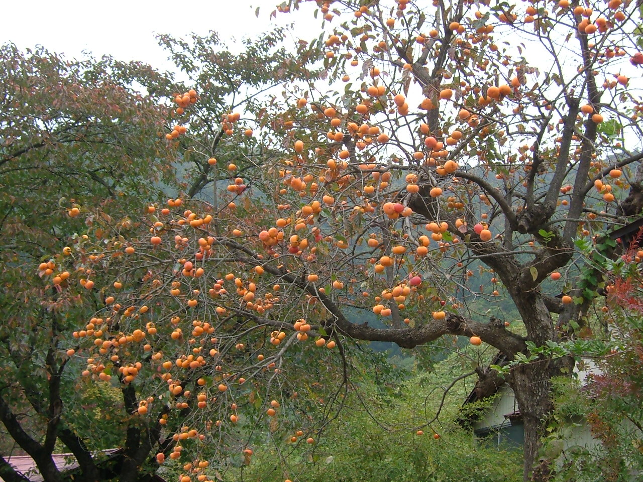

Yamagata Prefecture is the largest producer of cherries and pears in Japan. A large quantity of other kinds of fruits such as grapes, apples, peaches, melons, persimmons and watermelons are also produced.
Demographics

As of the 2020 census, Yamagata Prefecture had a population of 1,068,027. As of the latest estimates in October 2024, 10.4% of the population was under the age of 15, 54.0% was between 15 and 64, and 35.6% was over 65, with 16.0% aged 65 to 74, and 19.6% aged 75 or older.
Yamagata prefecture experienced its greatest growth period following the end of World War II, but then quickly began to slow down and eventually decline steadily.
In May 2025, the Yamagata prefectural government announced that the estimated population had fallen below 1 million. This marks the lowest population level recorded in the prefecture since the 1920 census.
| 1890 | 742,600 | 1920 | 968,925 | 1925 | 1,027,297 | 1930 | 1,080,034 | 1935 | 1,116,822 | 1940 | 1,118,153 | 1947 | 1,335,653 | 1950 | 1,357,347 | 1955 | 1,353,649 | 1960 | 1,320,664 | 1965 | 1,263,103 | 1970 | 1,225,618 | 1975 | 1,220,302 | 1980 | 1,251,917 | 1985 | 1,261,662 | 1990 | 1,258,390 | 1995 | 1,256,958 | 2000 | 1,244,147 | 2005 | 1,216,181 | 2010 | 1,168,924 | 2015 | 1,123,891 | 2020 | 1,068,027
City life
Yamagata City is the central hub for Yamagata Prefecture and has many shops and restaurants around its main station. It is also the location with the most western hotels and the primary place of lodging for visitors visiting this region. This city serves as a good hub to visit the surrounding cities and towns around this prefecture with bus lines and train lines linking almost every part of Yamagata from the station.
There are also many bars near the station giving this city a good night life for visitors to enjoy at the front of the station as well as the nanukamachi district in the downtown area of the city.
Festivals and events
Yamagata Prefecture has a number of annual festivals and events.
The largest is the Yamagata Hanagasa Festival (花笠祭り) which takes place in Yamagata City on the first weekend in August, when thousands of people perform the hanagasa dance in the city centre and attracts up to 300,000 spectators. Yamagata City is the home of the bi-annual Yamagata International Documentary Film Festival in October.
In February, a snow lantern festival is held in Yonezawa at the Uesugi Shrine. Hundreds of candle-lit lanterns light pathways dug into the snow around the shrine. Yonezawa is also the site of the Uesugi Festival (上杉祭り, uesugi matsuri) in mid-spring. The festival's highlight is a re-enactment of the Battle of Kawanakajima on the banks of the Matsukawa River.
In September, Yamagata Prefecture is famous for its imoni, a taro-root stew popular in Northern Japan during the autumn. Imonikai, taro-root soup parties, are very popular during this season, and many tourists come to Yamagata Prefecture specifically for its particular style of imoni.
Art
Beginning in 2003, Yamagata city officials with the aid of Tōhoku University of Art and Design began a three-year project in which the Buddhist art of the city's temples would be catalogued and compared to a set of guidelines in order to identify "cultural assets". One hundred and ninety temples have had their works of art examined and several significant examples of Buddhist sculpture have been discovered. At Heisenji Temple, in the Hirashimizu district, a particularly rare statue, a seated Vairocana Buddha made from zelkova wood, was found. Other significant works include sculptures from the Heian period (794–1185) and Kamakura period (1192–1333).
The Yamagata Museum of Art, located in Yamagata City, was opened in 1964 through the efforts of a foundation led by Yoshio Hattori, the president of Yamagata Shimbun and Yamagata Broadcasting Co, Ltd. The permanent collection consists of three types of art: Japanese and Asian, regional, and French. Special exhibitions are held periodically.
Language
Yamagata Prefecture is known for its local dialect Yamagata-ben, sometimes thought of as backward sounding in other parts of Japan. The 2004 movie Swing Girls (スウィングガールズ), co-written and directed by Shinobu Yaguchi, is set in Yamagata and makes use of Yamagata-ben for comedic purposes.
Sports

The sports teams listed below are based in Yamagata.
Football
- Montedio Yamagata
Volleyball
- Pioneer Red Wings (Tendō)
Basketball
- Passlab Yamagata Wyverns
Transportation
Airports
- Shonai Airport (Tokyo, Osaka, Sapporo by All Nippon Airways)
- Yamagata Airport (Tokyo, Osaka, Nagoya, Sapporo by Japan Airlines)
Railways
- Aterazawa Line
- Flower Nagai Line
- Ōu Main Line
- Rikuu East Line
- Rikuu West Line
- Senzan Line
- Uetsu Main Line
- Yamagata Shinkansen
- Yonesaka Line
Tourism
The temple of Yama-dera, carved into the mountainside near the city of Yamagata, is a major attraction.
The Dewa Sanzan are three holy mountains that form a traditional pilgrimage for followers of the Shugendō branch of Shintō. The famous Gojudo (five-story pagoda) is at the base of Mount Haguro, the lowest of the three mountains.
Mount Zaō is a famous winter ski resort, also known for its snow monsters (frozen snow-covered trees) in the winter, and the Okama crater lake, also known as the Goshiki Numa (Five Color Lake) because its colour changes according to the weather.
Ginzan Onsen (銀山温泉) is a Silver Mountain hot spring town located in the mountains of Obanazawa City, Yamagata Prefecture. The area originally developed around a silver mine.
File:220430 Bunshokan Yamagata Yamagata pref Japan01s3.jpg|Former Yamagata Prefectural Office File:Yamadera 2004-11.JPG|Yamadera niōmon File:Hagurosan Gojunto 2006-A.jpg|Mount Haguro, The Gojuto Pagoda File:Ginzan Onsen 2019 no.3.png|Ginzan Onsen Spa File:220430 ZaoOnsen Yamagata Yamagata pref Japan02s3.jpg|Zaō Onsen Ski Resort
Media
Newspapers
- Okitama Times https://web.archive.org/web/20070116044023/http://www.okitamatimes.co.jp/
- Shonai Nippo
- Yamagata Shimbun http://yamagata-np.jp/
- Yonezawa Shimbun
TV and radio
- Rhythm Station (JFN)
- SAY TV (FNN)
- TUY TV (JNN)
- YBC TV and Radio (NNN, JRN, and NRN)
- YTS TV (ANN)
Film
- Yamagata International Documentary Film Festival Yamagata is pictured in the 1991 Studio Ghibli film Only Yesterday directed by Isao Takahata.
Notes
References
- Nussbaum, Louis-Frédéric and Käthe Roth. (2005). Japan encyclopedia. Cambridge: Harvard University Press. ; OCLC 58053128
References
- "2020年度国民経済計算(2015年基準・2008SNA) : 経済社会総合研究所 - 内閣府".
- NHK Publishing. (24 May 2016)
- Nussbaum, Louis-Frédéric. (2005). "Yamagata prefecture" in {{Google books. p2QnPijAEmEC. ''Japan Encyclopedia'', pp. 1038-1039. p2QnPijAEmEC. p. 970
- Nussbaum, "Yamagata" in {{Google books. p2QnPijAEmEC. p. 1038
- Nussbaum, "Provinces and prefectures" in {{Google books. p2QnPijAEmEC. p. 780
- link. [[Ministry of the Environment (Japan). Ministry of the Environment]]. (31 March 2020)
- [http://www.data.jma.go.jp/obd/stats/etrn/view/monthly_s3_en.php?block_no=47588&view=1 Yamagata Station], [[Japan Meteorological Agency]]
- [http://www.data.jma.go.jp/obd/stats/etrn/view/monthly_s3_en.php?block_no=47520&view=1 Shinjo Station], [[Japan Meteorological Agency]]
- [http://www.data.jma.go.jp/obd/stats/etrn/view/monthly_s3_en.php?block_no=47587 Sakata Station], [[Japan Meteorological Agency]]
- "Yamagata (Japan): Prefecture, Cities, Towns and Villages - Population Statistics, Charts and Map".
- (October 1, 2024). "Current Population Estimates as of October 1, 2024".
- (October 1, 2020). "Statistics Bureau of Japan".
- link. (30 May 2025)
- (9 May 2022). "Yamagata City".
- (December 5, 2006). ["Yamagata: City unearths wealth of Buddhist Treasure"](http://www.asahi.com/english/Herald-asahi/TKY200612050117.html }}{{dead link). The Asahi Shimbun.
- "YIDFF Official Site". Yidff.jp.
This article was imported from Wikipedia and is available under the Creative Commons Attribution-ShareAlike 4.0 License. Content has been adapted to SurfDoc format. Original contributors can be found on the article history page.
Ask Mako anything about Yamagata Prefecture — get instant answers, deeper analysis, and related topics.
Research with MakoFree with your Surf account
Create a free account to save articles, ask Mako questions, and organize your research.
Sign up freeThis content may have been generated or modified by AI. CloudSurf Software LLC is not responsible for the accuracy, completeness, or reliability of AI-generated content. Always verify important information from primary sources.
Report