From Surf Wiki (app.surf) — the open knowledge base
Xerta
| Field | Value |
|---|---|
| name | Xerta |
| other_name | Cherta |
| settlement_type | Municipality |
| image_skyline | Vista general Xerta.jpg |
| image_flag | Bandera de Xerta.svg |
| image_shield | Escudo de Cherta.svg |
| pushpin_map | Spain Province of Tarragona#Spain Catalonia#Spain |
| pushpin_map_caption | Location in Catalonia |
| coordinates | |
| subdivision_type | Country |
| subdivision_name | |
| subdivision_type1 | Autonomous Community |
| subdivision_name1 | Catalonia |
| subdivision_type2 | Province |
| subdivision_name2 | Tarragona |
| subdivision_type3 | Comarca |
| subdivision_name3 | Baix Ebre |
| leader_title | Mayor |
| leader_name | Roger Aviñó Martí (2015) |
| area_footnotes | |
| area_total_km2 | 32.4 |
| elevation_m | 12 |
| population_as_of | |
| population_footnotes | |
| population_total | |
| population_density_km2 | auto |
| population_demonym | Xertolí, xertolina |
| postal_code_type | 430521 |
| website |
Xerta () is a town and municipality of the comarca of Baix Ebre. It has a population of .
It is established in a sharp bend to the right of the river Ebre, about 12 km upstream from the city of Tortosa in the province of Tarragona, Catalonia, Spain.
Geographical context
The municipality covers 33.55 km ². The Ebre river is the dividing line with the municipalities of Tivenys and Benifallet to the east. To the west, the land is hilly, and there are recent eastern foothills of the Iberian System. Tramontana noon, adjoins the "Coll del Musso" to Paüls, and the "Colls d'en Gràcia" of the "Tossal de la Cova del Bou", which borders with Alfara de Carles in the west. In the south the border coincides with a stretch of the gorge "la Conca" and then curve towards the north diagonally to the right and near the gorge "del Llop", with Aldover.
Xerta has good communication with Mora d'Ebre, Tortosa and the A-7 autopista; through the regional road (C-12) known as the "Eix de l'Ebre". Zaragoza was formerly with the rail line from the "Val de Zafán", closed in September 1973 and now converted into a greenway (110 km from Bajo Aragon and even Tortosa).
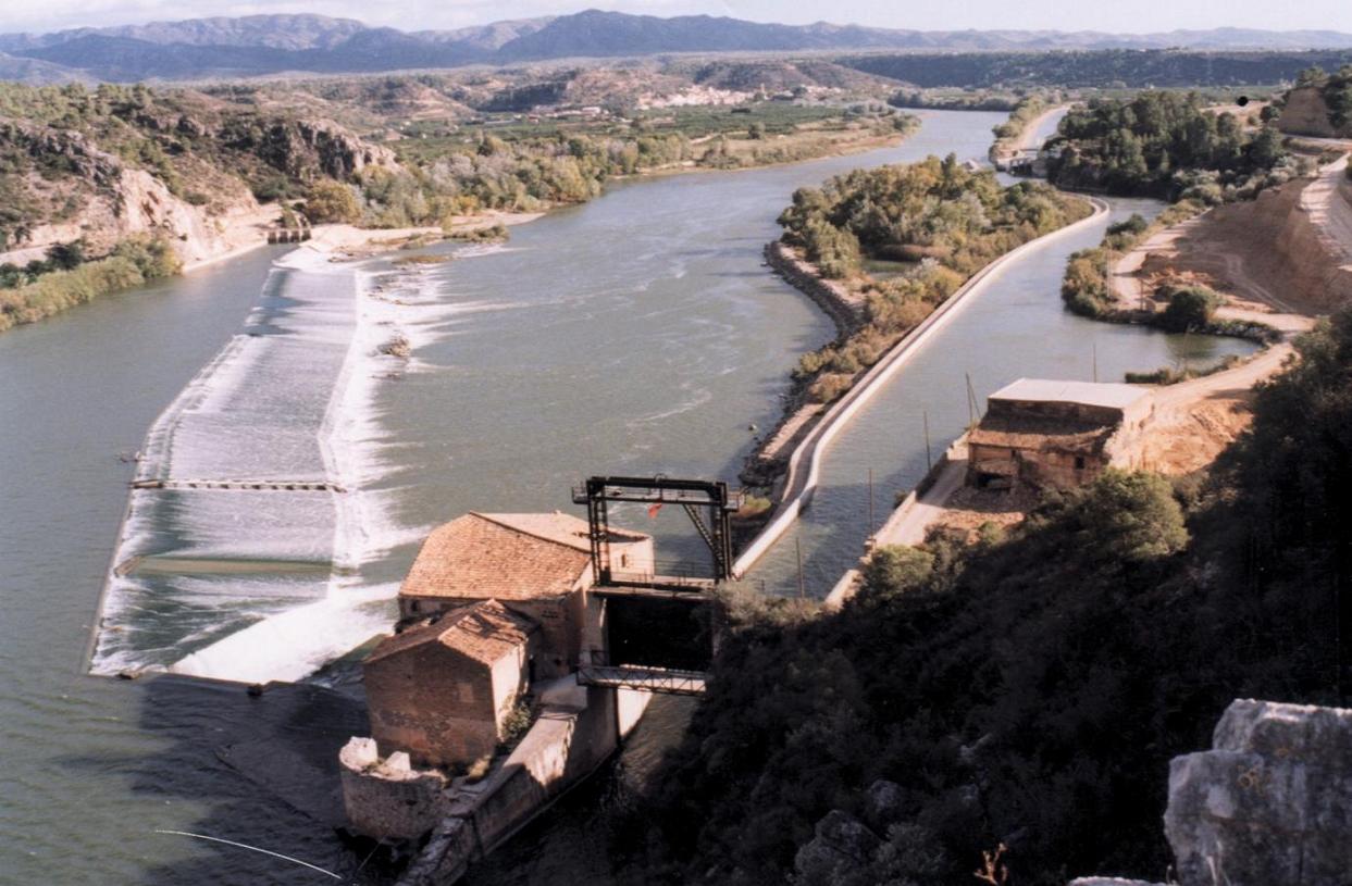
The Assut of Xerta
The Assut of Xerta is an important monument of hydraulic engineering declared Cultural Asset of National Interest in the category of Historical Monuments by the Government of Catalonia in 2002. It is located three kilometers upstream from the town. It is a dam built diagonally from side to side along the Ebre River about 375 feet. Its function is to divert water to the irrigation canals of the Right and Left of the Ebre.
Popular festivals
Summer Festivities of St. James
Summer festivals are dedicated to Saint James (July 25). Among the acts are the most traditional street bulls or paella at the riverside. A curiosity is the "White Night", a night on which people do not go to sleep. It starts with dancing in the outdoor courtyard of the school, culminating with a dance party accompanied by a brass band that runs through the village streets, arousing all xertolins after breakfast. It ends with chasing the bull in the streets which continues throughout the morning.
Festival of Saint Martin.
Another festival of this town is dedicated to our Patron Saint Martin (November 11). Some acts are the most traditional street bull chasing, the popular dinner of beef stew, or dancing the Jota Xertolina on the day of Saint Martin. In the square, at about five o'clock, all xertolins big and small start to congregate wearing the traditional costumes of Xerta squares fills with color, ready to dance the Jota Xertolina, a traditional dance that is kept alive by the locals. These and many more acts are prepared, and they are all very much enjoyed by the local population.
References
References
- "Ajuntament de Xerta". [[Generalitat of Catalonia]].
- "El municipi en xifres: Xerta". [[Institut d'Estadística de Catalunya.
This article was imported from Wikipedia and is available under the Creative Commons Attribution-ShareAlike 4.0 License. Content has been adapted to SurfDoc format. Original contributors can be found on the article history page.
Ask Mako anything about Xerta — get instant answers, deeper analysis, and related topics.
Research with MakoFree with your Surf account
Create a free account to save articles, ask Mako questions, and organize your research.
Sign up freeThis content may have been generated or modified by AI. CloudSurf Software LLC is not responsible for the accuracy, completeness, or reliability of AI-generated content. Always verify important information from primary sources.
Report