From Surf Wiki (app.surf) — the open knowledge base
WSR-74
Weather surveillance radar

Weather surveillance radar
| Field | Value |
|---|---|
| name | WSR-74 |
| image | File:berrimah-radar-darwin-nt.jpg |
| caption | WSR-74C Radar in Darwin, Northern Territory Australia |
| country | United States |
| introdate | |
| number | 68 WSR-74C |
| 5 WSR-74S | |
| type | Weather radar |
| frequency | 2890 MHz (WSR-74S S band) |
| 5400 MHz (WSR-74C C band) | |
| PRF | 259 Hz (WSR-74C) |
| 545 and 162 Hz (WSR-74S) | |
| beamwidth | 1.6° (WSR-74C) |
| 2° (WSR-74S) | |
| pulsewidth | 3 μs (WSR-74C) |
| 1 and 4 μs (WSR-74S) | |
| RPM | |
| range | 579 km |
| altitude | |
| diameter | 2.6 m (WSR-74C) |
| 3.7 m (WSR-74S) | |
| height | |
| width | |
| azimuth | |
| elevation | |
| precision | 0.9 km in range |
| power | 250 KW (WSR-74C)500 KW (WSR-74S) |
5 WSR-74S 5400 MHz (WSR-74C C band) 545 and 162 Hz (WSR-74S) 2° (WSR-74S) 1 and 4 μs (WSR-74S) 3.7 m (WSR-74S) WSR-74 radars were Weather Surveillance Radars designed in 1974 for the National Weather Service. They were added to the existing network of the WSR-57 model to improve forecasts and severe weather warnings. Some have been sold to other countries like Australia, Greece, and Pakistan.
Radar properties
There are two types in the WSR-74 series, which are almost identical except for operating frequency. The WSR-74C (used for local warnings) operates in the C band, and the WSR-74S (used in the national network) operates in the S band (like the WSR-57 and the current WSR-88D). S band frequencies are better suited because they are not attenuated significantly in heavy rain while the C Band is strongly attenuated, and has a generally shorter maximum effective range.
The WSR-74C uses a wavelength of 5.4 cm. It also has a dish diameter of 8 feet, and a maximum range of 579 km (313 nm) as it was used only for reflectivities (see Doppler dilemma).
History
The WSR-57 network was very spread out, with 66 radars to cover the entire country. There was little to no overlap in case one of these vacuum-tube radars went down for maintenance. The WSR-74 was introduced as a "gap filler", as well as an updated radar that, among other things, was transistor-based. In the early 1970s, Enterprise Electronics Corporation (EEC), based out of Enterprise, Alabama won the contract to design, manufacture, test, and deliver the entire WSR-74 radar network (both C and S-Band versions).
WSR-74C radars were generally local-use radars that didn't operate unless severe weather was expected, while WSR-74S radars were generally used to replace WSR-57 radars in the national weather surveillance network. When a network radar went down, a nearby local radar might have to supply updates like a network radar. NWS Lubbock received the first WSR-74C in August 1973 following widespread attention from the F5 Lubbock tornado of 1970.
128 of the WSR-57 and WSR-74 model radars were spread across the country as the National Weather Service's radar network until the 1990s. They were gradually replaced by the WSR-88D model (Weather Surveillance Radar - 1988, Doppler), constituting the NEXRAD network. The WSR-74 had served the NWS for two decades.
The last WSR-74C used by the NWS was located in Williston, ND, before being decommissioned at the end of 2012.
No WSR-74S's are in the NWS inventory today, having been replaced by the WSR-88D, but some of these radars are in commercial use.
Radar sites in the US
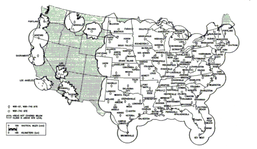
WSR-74 sites include the following two categories:
| WSR-74C Site | Commissioned | Decommissioned | ||
|---|---|---|---|---|
| Abilene, TX (ABI) | ||||
| Akron, OH (CAK) | ||||
| Albany, NY (ALB) | ||||
| Alpena, MI (APN) | ||||
| Atlanta, GA (ATL) | ||||
| Augusta, GA (AGS) | ||||
| Austin, TX (AUS) | ||||
| Baton Rouge, LA (BTR) | ||||
| Beckley, WV (BKW) | ||||
| Billings, MT (BIL) | ||||
| Bismarck, ND (BIS) | ||||
| Burlington, VT (BTV) | ||||
| Charlotte, NC (CLT) | ||||
| Chattanooga, TN (CHA) | ||||
| Cheyenne, WY (CYS) | ||||
| Cleveland, OH (CLE) | ||||
| Columbia, MO (COU) | ||||
| Columbia, SC (CAE) | ||||
| Columbus, GA (CSG) | ||||
| Columbus, OH (CMH) | ||||
| Concordia, KS (CNK) | ||||
| Corpus Christi, TX (CRP) | ||||
| Duluth, MN (DLH) | ||||
| Erie, PA (ERI) | ||||
| Fort Smith, AR (FSM) | ||||
| Fort Wayne, IN (FWA) | ||||
| Goodland, KS (GLD) | ||||
| Harrisburg, PA (HAR) | ||||
| Hartford, CT (BDL) | ||||
| Houghton Lake, MI (HTL) | ||||
| Huntsville, AL (HSV) | ||||
| Indianapolis, IN (IND) | ||||
| Las Vegas, NV (LAS) | ||||
| Los Angeles, CA (LAX) | ||||
| Louisville, KY (SDF) | ||||
| Lubbock, TX (LBB) | ||||
| Macon, GA (MCN) | ||||
| Madison, WI (MSN) | ||||
| Marquette, MI (MQT) | ||||
| Meridian, MS (MEI) | ||||
| Mobile, AL (MOB) | ||||
| Moline, IL (MLI) | ||||
| Montgomery, AL (MGM) | ||||
| Muskegon, MI (MKG) | ||||
| Norfolk, NE (OFK) | ||||
| North Platte, NE (LBF) | ||||
| Omaha, NE (OVN) | ||||
| Paducah, KY (PAH) | ||||
| Phoenix, AZ (PHX) | ||||
| Portland, OR (PDX) | ||||
| Raleigh, NC (RDU) | ||||
| Rapid City, SD (RAP) | ||||
| Rochester, MN (RST) | ||||
| San Angelo, TX (SJT) | ||||
| Savannah, GA (SAV) | ||||
| Shreveport, LA (SHV) | ||||
| Sioux Falls, SD (FSD) | ||||
| South Bend, IN (SBN) | ||||
| Springfield, IL (SPI) | ||||
| Topeka, KS (TOP) | ||||
| Tucson, AZ (TUS) | ||||
| Tulsa, OK (TUL) | ||||
| Tupelo, MS (TUP) | ||||
| Waco, TX (ACT) | ||||
| Waterloo, IA (ALO) | ||||
| Wichita Falls, TX (SPS) | ||||
| Williston, ND (ISN) | ||||
| Worcester, MA (ORH) |
| WSR-74S Site | Commissioned | Decommissioned | ||
|---|---|---|---|---|
| Alliance, NE (AIA) | ||||
| Binghamton, NY (BGM) | ||||
| Charleston, WV (CRW) | ||||
| Chatham, MA (CHH) | ||||
| Detroit, MI (DTW) | ||||
| Fargo, ND (FAR) | ||||
| Jackson, KY (JKL)WSR-74S providing local coverage | ||||
| Key West, FL (EYW) | ||||
| Longview, TX (GGG) | ||||
| Marseilles, IL (MMO) | ||||
| Memphis, TN (MEG) | ||||
| Patuxent River, MD (NHK) | ||||
| Portland, ME (PWM) | ||||
| San Juan, Puerto Rico (SJU) | ||||
| Volens, VA (VQN/7VM) | ||||
| West Palm Beach, FL (PBI) | ||||
References
tags--
References
- "Advanced Search - ITS". bldrdoc.gov.
- Paul Sirvatka. "WSR - Weather Surveillance Radar." Radar. College of DuPage. 4 Apr. 2006 [http://weather.cod.edu/sirvatka/radar.html http://weather.cod.edu/sirvatka/radar.html].
- (1998-06-01). "History of Operational Use of Weather Radar by U.S. Weather Services. Part I: The Pre-NEXRAD Era". American Meteorological Society.
- (July 2018)
- "NWS Lubbock, TX Office History". noaa.gov.
- [http://sysu1.wsicorp.com/unidata/intro.html http://sysu1.wsicorp.com/unidata/intro.html] {{webarchive. link. (April 20, 2008)
- "Weather radar shutdown imminent". Williston Herald.
- "Assessment of Nexrad Coverage and Associated Weather Services". nap.edu.
- (July 2018)
This article was imported from Wikipedia and is available under the Creative Commons Attribution-ShareAlike 4.0 License. Content has been adapted to SurfDoc format. Original contributors can be found on the article history page.
Ask Mako anything about WSR-74 — get instant answers, deeper analysis, and related topics.
Research with MakoFree with your Surf account
Create a free account to save articles, ask Mako questions, and organize your research.
Sign up freeThis content may have been generated or modified by AI. CloudSurf Software LLC is not responsible for the accuracy, completeness, or reliability of AI-generated content. Always verify important information from primary sources.
Report