From Surf Wiki (app.surf) — the open knowledge base
Woody Point, Newfoundland and Labrador
| Field | Value | ||
|---|---|---|---|
| official_name | Woody Point | ||
| settlement_type | Town | ||
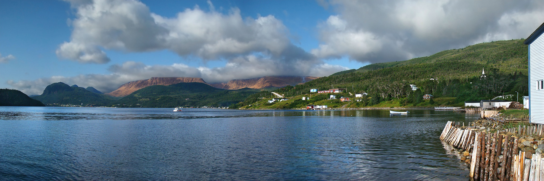
| image_skyline | Woody Point, Newfoundland.jpg | ||
| image_caption | Woody Point from lookout | ||
| pushpin_map | Newfoundland | ||
| pushpin_label_position | right | ||
| pushpin_map_caption | Location of Woody Point in Newfoundland | ||
| subdivision_type | Country | ||
| subdivision_name | |||
| subdivision_type1 | Province | ||
| subdivision_name1 | |||
| established_title | Settled | ||
| established_date | 1849 | ||
| established_title2 | Incorporated | ||
| established_date2 | 1956 | ||
| area_total_km2 | 2.91 | ||
| population_as_of | 2021 | ||
| population_total | 244 | ||
| population_density_km2 | auto | ||
| timezone | Newfoundland Time | ||
| utc_offset | −3:30 | ||
| timezone_DST | Newfoundland Daylight | ||
| utc_offset_DST | −2:30 | ||
| coordinates | |||
| elevation_m | 25 | ||
| postal_code_type | Postal code span | ||
| postal_code | A0K | ||
| area_code | 709 | ||
| blank_name | Highways | ||
| blank_info | |||
| module | {{Infobox lighthouse | embed=yes | qid = Q44452460 |
| yearbuilt | 1919 (first) | ||
| 1952 (second) | |||
| yearlit | 1959 (current) | ||
| shape | square frustum tower with balcony and lantern |
1952 (second)
Woody Point is a town located in the heart of Gros Morne National Park, on the western coast of Newfoundland. Situated on Bonne Bay, the Town of Woody Point encompasses three areas: Curzon Village, Woody Point and Winterhouse Brook. It has a total population of 244 residents. The downtown section of Woody Point is a Registered Heritage District, and the community has a waterfront with many heritage buildings and four Registered Heritage Structures recognized by Heritage Foundation of Newfoundland and Labrador. The community is served by Route 431.
History
French Shore
Europeans were slow to settle the west coast of Newfoundland. The British were concentrated on the east coast, and the French were on the Grand Banks. The 1713 Treaty of Utrecht gave the French some area on the west coast which was extended in 1783 to the entire coast.
British settlement was spreading, as well. In 1800 the first British settlement in the Bonne Bay area occurred in Woody Point with the establishment of the firm of Joseph Bird from Sturminster Newton. He had an agent and premises to serve the British fishing interests which were principally migratory at this point. When fishermen began to stay during the winter rather than return to England, the pattern for permanent settlement was laid.
By 1904, the French had left the area to pursue fisheries farther up the coast. By this time, Woody Point was bustling. It was considered the capital of the area with banking and customs offices, merchants, and a harbour full of domestic and foreign vessels.
First settlers
John Roberts and his wife, Emma, together with their four children are considered to be the first settlers of Woody Point. They came in 1849. By 1872, there were 129 families residing in the Bonne Bay area.
In 1873, the Bonne Bay Post Office was established in the home of J.R. Roberts, John Roberts' nephew. This house was one of the first built in the area and is still standing today. It is a blue clapboarded structure on the Shore Road left of the downtown. Plans are being made to restore this house.
Solomon Wilton was the second settler to Woody Point. It was Wilton who donated the land on which the present day Church of the Epiphany was built. A school and parsonage once stood on this spot. These early founding families are laid to rest in the Anglican cemetery on Shore Road.
Major events
In 1922, when Woody Point was experiencing the height of its population and commercial success, a devastating fire ripped through the downtown. The wind quickly carried the flames which shot all the way across the Bay to Norris Point. In all, 58 buildings were destroyed. The degree of commerce in the town never returned to the pre-fire level.
Most of the buildings currently on the waterfront date from after 1922, but there are some exceptions. The lighthouse was built in 1919. Also, the large grey and green house to the right of the Seaside Deli was built in the 1890s. This house was the scene of a riot in 1938.
Gallery
File:Woody Point, Newfoundland and Labrador.jpg |View from Norris Point Image:August sky over the table lands.jpg |August sky over the table lands Image:Winter in Woody Point (Newfoundland and Labrador).jpg | Winter in Woody Point File:Bonne Bay, 2006 (Woody Point).jpg | Bonne Bay Image:purple orchid.jpg | Spring Orchids Image:bonnebaysunset.jpg | Sunset on Bonne Bay Image:atticusonlookout.jpg |A dog on the path to the Lookout Image:lighthouseinfog.jpg |Lighthouse in fog Image:Green point rocks.jpg| Rocks at Green Point
Geography and Climate
Woody Point is underlain by a bedrock of mélange, with metagabbro and related rock on higher areas. Soils of the community and its surrounding region have been placed in the Serpentine Cove association of Brunisols developed on mafic or ultramafic parent material. Woody Point has a humid continental climate (Köppen Dfb) with extremely high winter snowfall and a strong winter seasonal lag, causing February to be the clearly coldest month. Summers are moderated by its seaside position, whereas precipitation remains high year round and rainfall is occurring during milder spells during winters. Woody Point is the snowiest year round inhabited place in Canada.
|Jan record high C = 15 |Feb record high C = 12.8 |Mar record high C = 16.5 |Apr record high C = 22.5 |May record high C = 25 |Jun record high C = 27 |Jul record high C = 29.5 |Aug record high C = 30.6 |Sep record high C = 27 |Oct record high C = 22 |Nov record high C = 18.5 |Dec record high C = 16.1 |Jan record low C = -25 |Feb record low C = -31 |Mar record low C = -31 |Apr record low C = -18 |May record low C = -7.2 |Jun record low C = -1 |Jul record low C = 2.8 |Aug record low C = 2.8 |Sep record low C = -1.7 |Oct record low C = -6.7 |Nov record low C = -13 |Dec record low C = -22.5
Canadian Climate Normals 1971–2000, accessed 15 July 2009
Demographics
In the 2021 Census of Population conducted by Statistics Canada, Woody Point, Bonne Bay had a population of living in of its total private dwellings, a change of from its 2016 population of . With a land area of 3.78 km2, it had a population density of in 2021.
Arts and culture
Woody Point is home to the Writers at Woody Point festival and Gros Morne Summer Music. Woody Point featured in season six of the television program Still Standing.
References
References
- {{Cite rowlett. nflw
- {{cite ngall. 110. 2016
- http://gac.esd.mun.ca/nl/pdf/Field%20Guide%202003.pdf {{Webarchive. link. (4 March 2016 From the Intertidal Zone to the Upper Mantle – The Amazing Geology of Gros Morne National Park, p.8)
- http://sis.agr.gc.ca/cansis/publications/surveys/nf/nf11/nf11_report.pdf Soils of the Sandy Lake-Bay of Islands Area, Western Newfoundland
- "Snowiest Places in Canada - Current Results".
- (February 9, 2022). "Population and dwelling counts: Canada, provinces and territories, census divisions and census subdivisions (municipalities), Newfoundland and Labrador". [[Statistics Canada]].
- "ArtsNL – Writers at Woody Point".
- "Gros Morne Summer Music". Creative Gros Morne.
- (3 September 2019). "From Amherstburg to Woody Point: All of the small towns Still Standing has visited so far". CBC.ca.
This article was imported from Wikipedia and is available under the Creative Commons Attribution-ShareAlike 4.0 License. Content has been adapted to SurfDoc format. Original contributors can be found on the article history page.
Ask Mako anything about Woody Point, Newfoundland and Labrador — get instant answers, deeper analysis, and related topics.
Research with MakoFree with your Surf account
Create a free account to save articles, ask Mako questions, and organize your research.
Sign up freeThis content may have been generated or modified by AI. CloudSurf Software LLC is not responsible for the accuracy, completeness, or reliability of AI-generated content. Always verify important information from primary sources.
Report