From Surf Wiki (app.surf) — the open knowledge base
Wisconsin glaciation
Glaciation in North America during the Last Glacial Period
Glaciation in North America during the Last Glacial Period
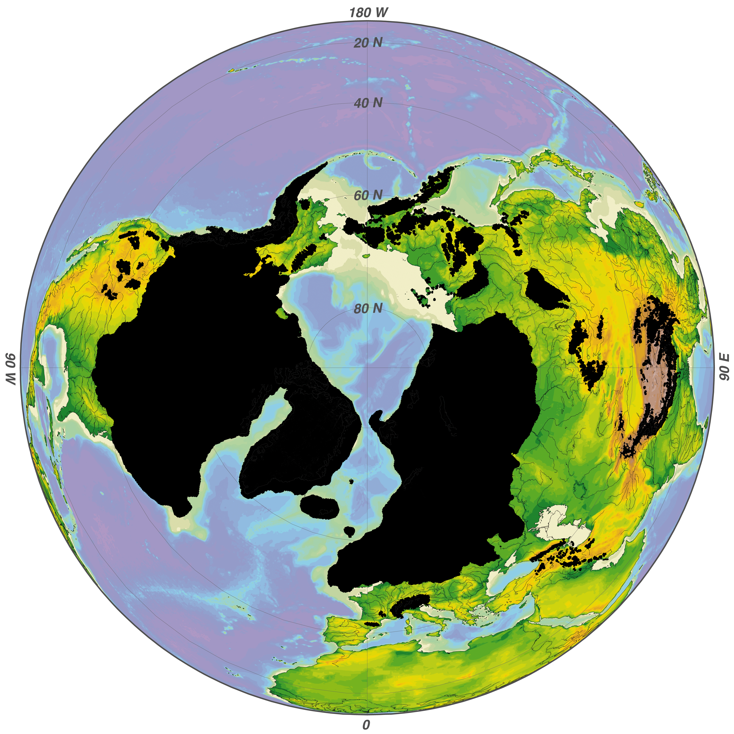
The Wisconsin glaciation, also called the Wisconsin glacial episode, was the most recent glacial period of the North American ice sheet complex, peaking more than 20,000 years ago. This advance included the Cordilleran Ice Sheet, which nucleated in the northern North American Cordillera; the Innuitian ice sheet, which extended across the Canadian Arctic Archipelago; the Greenland ice sheet; and the massive Laurentide Ice Sheet, which covered the high latitudes of central and eastern North America. This advance was synchronous with global glaciation during the last glacial period, including the North American alpine glacier advance, known as the Pinedale glaciation. The Wisconsin glaciation extended from about 75,000 to 11,000 years ago, between the Sangamonian Stage and the current interglacial, the Holocene. The maximum ice extent occurred about 25,000–21,000 years ago during the last glacial maximum, also known as the Late Wisconsin in North America.

This glaciation radically altered the geography north of the Ohio River, creating the Great Lakes. At the height of the Wisconsin Episode glaciation, the ice sheet covered most of Canada, the Upper Midwest, and New England, as well as parts of Idaho, Montana, and Washington. On Kelleys Island in Lake Erie, northern New Jersey and in New York City's Central Park, the grooves left in rock by these glaciers can be easily observed. In southwestern Saskatchewan and southeastern Alberta a suture zone between the Laurentide and Cordilleran ice sheets formed the Cypress Hills, North America's northernmost point that remained south of the continental ice sheets. During much of the glaciation, sea level was low enough to permit land animals, including humans, to occupy Beringia (the Bering Land Bridge) and move between North America and Siberia. As the glaciers retreated, glacial lakes were breached in great glacial lake outburst floods such as the Kankakee Torrent, which reshaped the landscape south of modern Chicago as far as the Ohio and Mississippi Rivers.
Timeline
Two related movements have been termed Wisconsin: Early Wisconsin and Late Wisconsin. The Early Wisconsin was the bigger of the two and extended farther west and south. It retreated an unknown distance before halting. During this period of quiet, the glacial deposits were eroded and weathered. This first Wisconsin period erased all the Illinoian glacial topography that its glaciers extended over. The Late Wisconsin ice sheet extended more towards the west than the earlier movements. This may have been due to changes in the accumulation center of the ice sheet, topographic changes introduced by the Early phase or by pressure changes in the ice mass in the north.
| Table I | Table VII – Estimated Age of Glacial Episodes (Leverett) | Age | Years before Present (YBP) |
|---|---|---|---|
| Culmination of Late Wisconsin | 50,000 | ||
| Culmination of Early Wisconsin | 100,000 | ||
| Beginning of Wisconsin | 150,000 | ||
| Culmination of Illinoian | 300,000 | ||
| Beginning of Illinoian | 350,000 | ||
| 0-8137-2337-X}} | 550,000 | ||
| Beginning of Pre-Illinoian | 1,200,000 |
Continental ice sheets
Ice caps
| Table II | Ice Caps | Laurentide Ice Sheet |
|---|---|---|
| Keewatin | Nova Scotia Ice Cap | Newfoundland Ice Cap |
--
Laurentide ice sheet
Main article: Laurentide Ice Sheet
| Table III Laurentide Ice Sheet | Glacial lobes and sublobes of the southern Laurentide Ice Sheet during the late Wisconsin Glaciation. | Major Lobes |
|---|---|---|
| Minor Lobes | ||
| Des Moines | Grantsburg | St. Louis |
| Lake Superior | Wadena | Chippewa |
| Green Bay | ||
| Lake Michigan | Delavan | Harvard-Princeton |
| Minor lobes: Milwaukee, Two Rivers; Straits of Mackinac | ||
| Saginaw | ||
| Lake Huron | East White | Miami |
| Lake Erie | ||
| Lake Ontario | Lake Champlain | Hudson River |
| unnamed lobe in Quebec – New England | Connecticut Valley | Buzzards Bay |
Labrador
The Labrador ice dome centered east of Hudson Bay. Expanding towards the southwest, it reached into the eastern edge of Manitoba and across the Great Lakes to the Ohio River, upwards of 1600 mi from its source. Its eastern lobes covered New England and reached south to Cape Cod and Long Island, New York.
Keewatin
The Keewatin ice dome began west of Hudson Bay in the Canadian Territory of Keewatin. The ice moved south some 1500 mi into Kansas and Missouri. To the west, it reached 1000 mi to the foothills of the Rocky Mountains.
Cordilleran ice sheet
Main article: Cordilleran ice sheet
The Cordilleran Ice Sheet has left remnants throughout the Northern Rocky Mountains, covering British Columbia and reaching into northern Washington State and Montana. The Cordilleran ice sheet has more of an Alpine style of many glaciers merged into a whole. The striations made by the ice field in moving over the bedrock show that it moved principally to the west through the passes of the coast range.
Innuitian ice sheet
Main article: Innuitian ice sheet
The Innuitian ice sheet was centered on the Queen Elizabeth Islands.
Formation of proglacial and prehistoric lakes

Whenever the ice sheet melted from the north at a moraine, water would begin to pond in the divide between a moraine and the ice front. The ice would act as a dam as water could not drain through the ice sheet, which in the Wisconsin period covered most of the proglacial river valleys. Numerous small, isolated water bodies formed between the moraine and the ice front. As the ice sheet would continue to melt and recede northward, these ponds combined into proglacial lakes. In areas without an available outlet, the water levels would either continue to rise until reaching one or more low spots along the rim of a moraine, or the ice sheet would retreat, opening access to a lower portion of the moraine. Multiple outlets could form through low spots too until one would become dominant after erosion lowered both the outlet and lake surface.
Meltwater

Stages of the Wisconsin episode
| Table IV | Maxima of the Wisconsin ice sheets | Western Ice | Eastern Ice | Proximate years ago | Position of ice border |
|---|---|---|---|---|---|
| Mankato | Valders | 25,000 | Northern Washington, Idaho, and Montana to the Continental Divide – north of Edmonton – 65 miles east of Edmonton – northwest corner of North Dakota – Des Moines – west end of Lake Superior – Milwaukee – Port Huron – Buffalo – Schuylerville – St. Johnsbury. | ||
| (Great reduction of ice) | Cary | 27,500 | Minneapolis – north Wisconsin – south of Chicago – Central Ohio – 50 miles south of Buffalo – Binghamton - Northampton | ||
| Tazewell | 40,000 | Rockford, Ill. – Peoria – south of Indianapolis – north of Cincinnati – northwestern Pennsylvania – central Long Island | |||
| Iowan | No known ice | 65,500 | Northern Washington, Idaho, and Montana – northwest North Dakota – east central Iowa - Minneapolis |
Role in human migration
Prehistoric human migration was likely greatly influenced by this last glacial period, as during much of the Wisconsin era, the formation of a land bridge known as Beringia across the Bering Strait is believed to have allowed human occupation of this area which provided potential access for some of the first humans to move between North America and Siberia in Asia (see Settlement of the Americas). Other human migration routes also opened during interglacial periods in both Europe and Asia.
Flora and fauna
North American flora and fauna species were distributed quite differently during the Wisconsin era, due to altered temperatures, surface water distribution, and in some cases coverage of earth surface by glaciers. A number of scientific studies have been conducted to determine species distribution, particularly during the Late Wisconsin and early to mid-Holocene. An example of findings is from the investigation of flora species using pollen core samples in present-day California. Here in the Waterman Hills researchers found that Juniperus osteosperma and Pinus monophylla were early to mid-Holocene dominant trees, while Monardella arizonica has been a continuously present understory plant. Celtis reticulata is an example of a plant present in the early Holocene following Wisconsin glacial retreat, a species no longer present at the Waterman Mountains site.
References
References
- SERC Media; Glacial Grooves, Central Park; Image 14884 is a 208 by 173 pixel JPEG; Uploaded: Apr5 09; Wayne Powell, CUNY Brooklyn College; http://serc.carleton.edu/details/images/14884.html
- Chapter II. Glacial History of the Huron-Erie Basin; Geological Report on Wayne County; W.H. Sherzer; Michigan Geological and Biological Survey, Publication 12, Geological Series 9; Lansing, Michigan; Wynkoop Hallenbeck Crawford Co., State Printers; 1913
- Attig, John W.; Mickelson, David M. (1999). Glacial processes past and present. Boulder, Colo: The Geological Society of America, Inc. {{ISBN. 0-8137-2337-X
- Boellstorff, J (1978). "Chronology of some Late Cenozoic deposits from the central United States and the Ice Ages"(pdf). Transactions of the Nebraska Academy of Science 6: 35–49. Retrieved 2012-04-04.
- Geological Framework and Glaciation of the Eastern Area; Christopher L. Hill; pg 82-98
- The southern Laurentide Ice Sheet; Cavid M. Mickelson and Patrick M. Colgan; Department of Geology, University of Wisconsin Madison; Madison, Wisconsin; 2003
- Chamberlin, Thomas C. and Salisbury, Rollin T., Geology, 3 Vols. 1906, Vol III., pp. 330-333.
- Chapman, L.J. and D.F. Putnam. 1984. ''The Physiography of Southern Ontario''. Third edition. Ontario Geological Survey, Special Volume No.2. Government of Ontario, Toronto.
- Correlation of Wisconsin Glacial Maxima; Ernst Antevs; ca 1943; The Quaternary Geology of Southeastern Wisconsin with a Chapter on the Older Rock Formations, Professional Paper 106; William C. Alden; United States Geological Survey; Government Printing Office, Washington, D.C.; 1918
- Harm J. De Blij. 2005. ''Why geography matters: three challenges facing America'', 308 pages, p.69
- Ann G. Harris, Esther Tuttle, Sherwood D. Tuttle. 1997. ''Geology of National Parks: Fifth Edition'', Iowa, Kendall/Hunt Publishing {{ISBN. 0-7872-5353-7
- [http://www.globaltwitcher.com/artspec_information.asp?thingid=90792 C. Michael Hogan, 2009. ''Elephant Tree: Bursera microphylla'', GlobalTwitcher.com, ed. N. Stromberg]
This article was imported from Wikipedia and is available under the Creative Commons Attribution-ShareAlike 4.0 License. Content has been adapted to SurfDoc format. Original contributors can be found on the article history page.
Ask Mako anything about Wisconsin glaciation — get instant answers, deeper analysis, and related topics.
Research with MakoFree with your Surf account
Create a free account to save articles, ask Mako questions, and organize your research.
Sign up freeThis content may have been generated or modified by AI. CloudSurf Software LLC is not responsible for the accuracy, completeness, or reliability of AI-generated content. Always verify important information from primary sources.
Report