From Surf Wiki (app.surf) — the open knowledge base
Whitianga
Town in Waikato, New Zealand
Town in Waikato, New Zealand
| Field | Value |
|---|---|
| name | Whitianga |
| image_skyline | Albert Street, Whitianga.jpg |
| image_caption | Albert Street in Whitianga |
| subdivision_type | Country |
| subdivision_name | New Zealand |
| subdivision_type1 | Region |
| subdivision_name1 | Waikato |
| subdivision_type2 | District |
| subdivision_name2 | Thames-Coromandel District |
| subdivision_type3 | Ward |
| subdivision_name3 | Mercury Bay ward |
| subdivision_type4 | Community Board |
| subdivision_name4 | Mercury Bay Community |
| leader_title | Council |
| leader_name | Thames-Coromandel District Council |
| leader_title1 | Regional council |
| leader_name1 | Waikato Regional Council |
| leader_title2 | Mayor of Thames-Coromandel |
| leader_name2 | |
| leader_title3 | Coromandel MP |
| leader_name3 | |
| leader_title4 | Hauraki-Waikato MP |
| leader_name4 | |
| seat_type | Electorates |
| seat | |
| mapframe | yes |
| mapframe-zoom | 9 |
| coordinates | |
| area_footnotes | |
| area_total_km2 | 17.20 |
| population_total | |
| population_as_of | |
| population_footnotes | |
| population_density_km2 | auto |
| postal_code_type | Postcode(s) |
| postal_code | 3510 |
| mapframe-zoom = 9
Whitianga is a town on the Coromandel Peninsula, in the Waikato region of New Zealand's North Island. The town is located on Mercury Bay, on the northeastern coast of the peninsula. The town has a permanent population of as of making it the second-largest town on the Coromandel Peninsula behind Thames.
Demographics
Stats NZ describes Whitianga as a small urban area, which covers 17.20 km2. It had an estimated population of as of with a population density of people per km2.
Whitianga has grown rapidly since 1945, when it had a population of 443, with 1,427 in 1976 and 3,540 in 1996.
Whitianga had a population of 6,054 in the 2023 New Zealand census, an increase of 561 people (10.2%) since the 2018 census, and an increase of 1,644 people (37.3%) since the 2013 census. There were 3,000 males, 3,048 females and 6 people of other genders in 2,586 dwellings. 1.6% of people identified as LGBTIQ+. The median age was 54.2 years (compared with 38.1 years nationally). There were 831 people (13.7%) aged under 15 years, 717 (11.8%) aged 15 to 29, 2,526 (41.7%) aged 30 to 64, and 1,977 (32.7%) aged 65 or older.
People could identify as more than one ethnicity. The results were 89.6% European (Pākehā); 15.2% Māori; 2.7% Pasifika; 3.9% Asian; 0.6% Middle Eastern, Latin American and African New Zealanders (MELAA); and 2.3% other, which includes people giving their ethnicity as "New Zealander". English was spoken by 98.4%, Māori language by 2.7%, Samoan by 0.2%, and other languages by 6.9%. No language could be spoken by 1.2% (e.g. too young to talk). New Zealand Sign Language was known by 0.3%. The percentage of people born overseas was 19.1, compared with 28.8% nationally.
Religious affiliations were 28.2% Christian, 0.8% Hindu, 0.1% Islam, 0.6% Māori religious beliefs, 0.8% Buddhist, 0.3% New Age, 0.1% Jewish, and 1.2% other religions. People who answered that they had no religion were 59.6%, and 8.4% of people did not answer the census question.
Of those at least 15 years old, 765 (14.6%) people had a bachelor's or higher degree, 3,057 (58.5%) had a post-high school certificate or diploma, and 1,395 (26.7%) people exclusively held high school qualifications. The median income was $32,200, compared with $41,500 nationally. 357 people (6.8%) earned over $100,000 compared to 12.1% nationally. The employment status of those at least 15 was that 1,971 (37.7%) people were employed full-time, 855 (16.4%) were part-time, and 129 (2.5%) were unemployed.
| Name | Area | |||||||
|---|---|---|---|---|---|---|---|---|
| (km2) | Population | Density | ||||||
| (per km2) | Dwellings | Median age | Median | |||||
| income | New Zealand | 38.1 years | $41,500 | |||||
| Whitianga North | 12.51 | 1,749 | 140 | 717 | 54.2 years | $34,600 | ||
| Whitianga South | 2.62 | 3,276 | 1,250 | 1,437 | 52.9 years | $30,900 | ||
| Whitianga Waterways | 2.06 | 1,029 | 500 | 432 | 58.6 years | $32,200 |
Geography
Whitianga is located on the eastern side of the Coromandel Peninsula, 191 km from Auckland (by road; 84 km direct distance), 93 km from Thames, 42 km from Tairua. It is situated on the coast of Mercury Bay along the 5 km long east-facing Buffalo Beach. In 1928 there was a controversy about changing the name of the town to Mercury Bay. On 21 June 2019 Whitianga was Gazetted as the official name. The town centre is at the southern end of the beach.
Buffalo Beach is named after , a Royal Navy ship which was wrecked during a storm while anchored in Mercury Bay. Her anchor can be seen at a monument at Buffalo Beach.
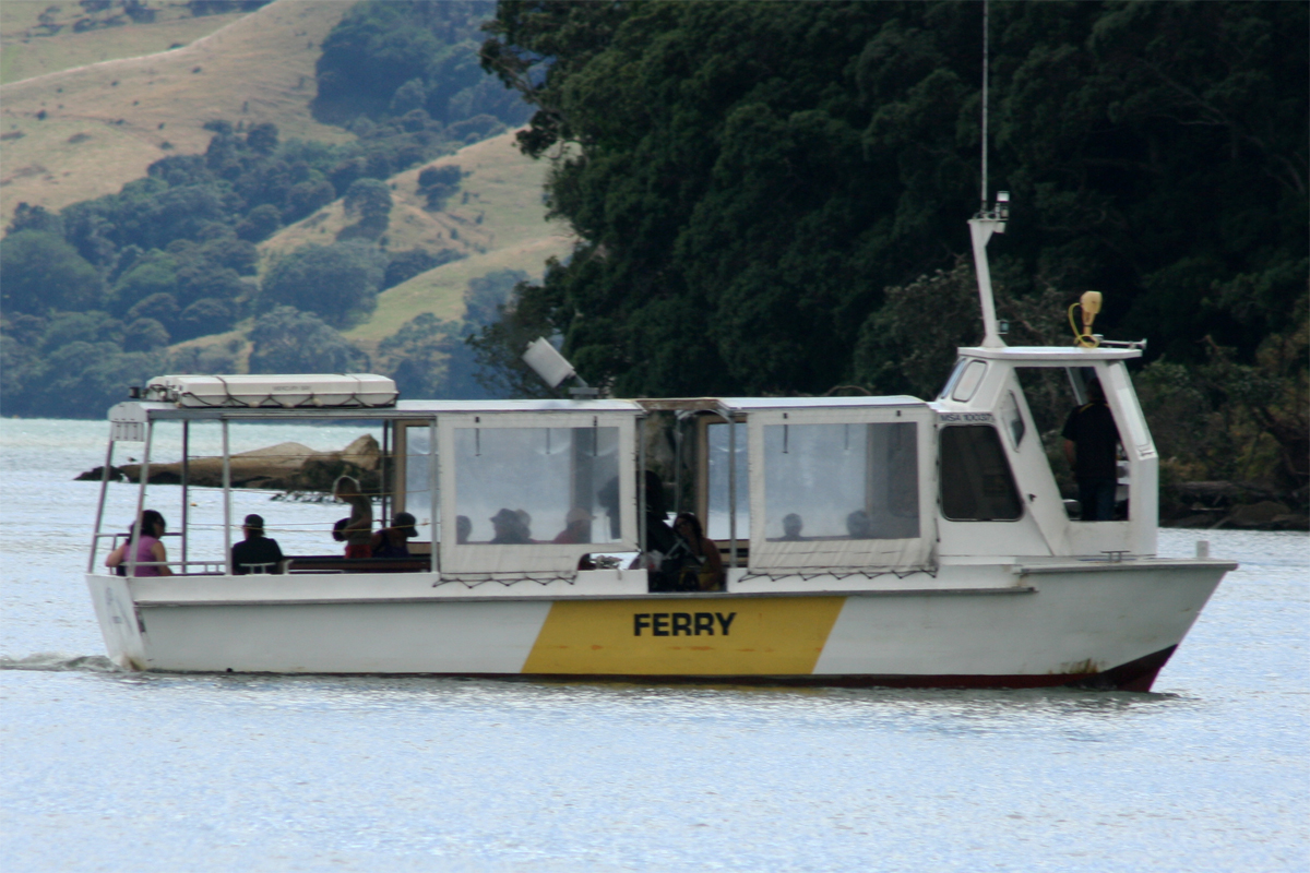
A passenger ferry crosses from Whitianga to Ferry Landing, close to Cooks Beach. The alternative to the two-minute ferry crossing is a 45-minute drive around Whitianga Harbour.

Climate
| Jan record high C = 31.9 | Feb record high C = 33.1 | Mar record high C = 30.3 | Apr record high C = 27.8 | May record high C = 23.5 | Jun record high C = 22.4 | Jul record high C = 21.5 | Aug record high C = 21.7 | Sep record high C = 22.8 | Oct record high C = 26.7 | Nov record high C = 30.9 | Dec record high C = 30.9 | year record high C = 33.1 | Jan avg record high C = 27.9 | Feb avg record high C = 28.0 | Mar avg record high C = 26.1 | Apr avg record high C = 24.0 | May avg record high C = 21.1 | Jun avg record high C = 19.1 | Jul avg record high C = 17.6 | Aug avg record high C = 18.5 | Sep avg record high C = 20.1 | Oct avg record high C = 22.1 | Nov avg record high C = 24.3 | Dec avg record high C = 26.2 | year avg record high C = 28.7 | Jan avg record low C = 8.1 | Feb avg record low C = 8.4 | Mar avg record low C = 7.2 | Apr avg record low C = 3.9 | May avg record low C = 1.7 | Jun avg record low C = -0.3 | Jul avg record low C = -0.9 | Aug avg record low C = 0.3 | Sep avg record low C = 1.4 | Oct avg record low C = 3.0 | Nov avg record low C = 4.9 | Dec avg record low C = 7.0 | year avg record low C = -1.5 |Jan record low C = 4.4 |Feb record low C = 3.6 |Mar record low C = 1.0 |Apr record low C = -0.8 |May record low C = -2.5 |Jun record low C = -4.2 |Jul record low C = -2.6 |Aug record low C = -2.3 |Sep record low C = -1.3 |Oct record low C = -1.8 |Nov record low C = 2.2 |Dec record low C = 3.9 |year record low C = -4.2 |access-date = 20 May 2024}}{{cite web |access-date = 20 May 2024}}{{cite web |access-date = 13 Jul 2025}}
History
Māori history
Whitianga has been continuously occupied for more than a thousand years since Māori explorer Kupe's iwi (tribe) settled here after his visit in about 950 AD. Following this visit, many of Kupe's tribe settled here. Te Whitianga o Kupe is the original place name of the town, meaning Kupe's crossing place.
Whitianga Pā, located on the ferry landing side of the river is a notable site. According to Ngāti Hei history, the earliest known chief occupying the rock was Hei Turepe. The pā is protected on three sides by sheer cliffs. The hill leading up to the pā on the fourth side is defended by a 22-foot man-made ditch which is now part of the track leading down to Back Bay where pā inhabitants had access to shellfish. On Cook's visit to the site in November 1769, the inhabitants who welcomed him believed the pā had been disused for a generation since it had been attacked by a Tauranga chief who married the slain chief's wife and settled peacefully into the area. Whitianga rock has several holes cut into the stone that were used as firepits, water stores, and palisade holes. Cook noted burnt palisade stumps as evidence that an earlier attack had evicted the ancient pā's residents.
Captain Cook's visit – 1769

The people of Hei commemorated their leader in a few place names, one being the bay at the head of which he had settled, Te Whanganui A Hei, (the Great Bay of Hei). This large sheltered bay was later renamed by Captain James Cook when he came here in November 1769 to observe the transit of Mercury. Cook was accompanied by Charles Green, the Royal Society expedition astronomer who died on the homeward journey in 1771.
From Cook's journal – "my reasons for putting in here were the hopes of discerning a good harbour and the desire I had of being in some convenient place to observe the Transit of Mercury, which happens on the 9th instant and will be wholly visible here if the day is clear between 5 and 6 o'clock." Cook also named the Whitianga Harbour "River of Mangroves" and this area is still referred to as "The River".
The sighting of the Transit of Mercury is commemorated at Cooks Beach by a cairn of Coromandel granite which tells the story: "In this bay was anchored 5 Nov 1769, HMS Endeavour, Lieutenant James Cook RN, Commander. He observed the transit of Mercury and named this bay."
European settlement
The original European settlement was situated on the opposite side of the river from approximately 1836 to 1881.
Whitianga stone wharf, built in 1838 on that east bank of the river, is the oldest remaining wharf in the country. It served a timber mill and shipbuilding yard. It was renovated in 2015. The ferry across the river uses the wharf as its eastern terminal.

Whitianga hotel wharf was built in the early 1870s. Coromandel County Council took formal ownership of it in 1926. By 1927 there were complaints that it was silting up. On 4 March 1932 a replacement was completed. It was removed in May 1964. SS Fingal was launched in 1879 to serve Tauranga, Mercury Bay and Tairua and became part of the Northern Steamship Company fleet in 1881. Their weekly service from Auckland ended about 1947. The Minister of Conservation approved construction of a marina in the former wharf area on 24 November 1992.
HMS Buffalo is a wreck in Mercury Bay; this ship was the first ship to settle the people of the Adelaide company who established the city of Adelaide in South Australia.
Industry

Historically, Whitianga was a centre for boat building, kauri milling, flax milling, gold mining and gum digging. For many years, it was a leading timber port, with sailing ships from Norway, Sweden, France, Italy and Great Britain coming to load timber. Overseas vessels of 2000 tons with a draught of 18" and carrying with their decks loads over a million feet of timber worked the harbour entrance. The larger ships were towed into the port from near Centre Island. Over a period of sixty years, it is estimated over 500 million feet of kauri was exported from the Whitianga district.
The first kauri gum was exported in 1844. It reached its peak in 1899 when over 11,000 long tons of gum was exported at an average of $120 per ton.
Today Whitianga serves as a small regional centre for the eastern side of the Coromandel Peninsula and Mercury Bay area. It is a focal point for local fishing, farming and tourism industry, such as the nearby Te Whanganui-A-Hei (Cathedral Cove) marine reserve and associated famous beach and cave. Cathedral Cove was used in the movie The Chronicles of Narnia: Prince Caspian.
The area surrounding Whitianga (222 square km) is currently under a mineral prospecting license granted by the Crown to mining company Waihi Gold (a subsidiary of Newmont Corporation Colorado, USA).
Education
Mercury Bay Area School is a coeducational composite (years 1–13) school with a roll of as of The first primary school opened in the area in 1872. A District High School opened in 1951 and moved to the present site two years later. In February 1981 it became an area school.
Transport
Whitianga is served by State Highway 25, the main highway looping around the Coromandel Peninsula. It is also served by the small Whitianga Aerodrome, which receives flights by Air Auckland with their Cessna 172 and 206 on a regular basis, FlyStark with their Cessna 172 and GippsAero GA8 Airvan aeroplanes and Sunair with their Cessna 172 and Piper Aztec planes. InterCity buses and Go Kiwi Shuttle serve the community with transportation to Whitianga from Thames, Auckland and other locations around the Coromandel Peninsula and North Island.
Media
Whitianga is served by The Mercury Bay Informer, The Hauraki Herald, Coromandel's More FM, and Coromandel's CFM.
Events
An annual scallop festival is held in September every year to celebrate seafood, particularly scallops.
The Whitianga Speed Festival was held in 2009 and 2010.
A New Year's Eve festival and concert, known as Coromandel Gold, was held from 2009 to 2012.
References
References
- "Stats NZ Geographic Data Service".
- {{NZ census 2018. Whitianga North (167000) and Whitianga South (167100)
- (7 November 1945). "Slight decdrease. Hauraki Plains Gazette".
- Statistics, New Zealand Department of. (1977). "1976 Census of Population and Dwellings". The Department.
- "Statistical Area, Regional Council and Urban and Rural Area by Census Night and Census Usually Resident Population Counts, 1991, 1996 and 2001".
- "Totals by topic for dwellings, (RC, TALB, UR, SA3, SA2, Ward, Health), 2013, 2018, and 2023 Censuses". Stats NZ – Tatauranga Aotearoa – Aotearoa Data Explorer.
- "Totals by topic for individuals, (RC, TALB, UR, SA3, SA2, Ward, Health), 2013, 2018, and 2023 Censuses". Stats NZ – Tatauranga Aotearoa – Aotearoa Data Explorer.
- "Totals by topic for individuals, (RC, TALB, UR, SA3, SA2, Ward, Health), 2013, 2018, and 2023 Censuses". Stats NZ - Tatauranga Aotearoa - Aotearoa Data Explorer.
- "Totals by topic for individuals, (RC, TALB, UR, SA3, SA2, Ward, Health), 2013, 2018, and 2023 Censuses". Stats NZ - Tatauranga Aotearoa - Aotearoa Data Explorer.
- "Totals by topic for individuals, (RC, TALB, UR, SA3, SA2, Ward, Health), 2013, 2018, and 2023 Censuses". Stats NZ - Tatauranga Aotearoa - Aotearoa Data Explorer.
- (25 July 1928). "Whitianga or, Mercury Bay? Thames Star".
- "Whitianga".
- https://x.com/MetService/status/1997529128288076025
- (26 July 2009). "Old Stone Wharf, Ferry Landing".
- "Whitianga Old Stone Wharf".
- "History".
- "Whitianga Heritage Area".
- (27 February 1926). "Auckland Star".
- (19 October 1927). "Coromandel news. New Zealand Herald".
- (1 April 1932). "Work of the month. Thames Star".
- "Ministry of Works Files – Mercury Bay / Whitianga".
- (17 December 1879). "Shipping. New Zealand Herald".
- (17 September 1881). "Auckland Star".
- (3 September 1947). "Peninsula news. Hauraki Plains Gazette".
- Robert McClean. (April 1999). "Eastern Coromandel foreshore, fisheries and coastal issues report. Report on the Wai 110 claim".
- "What is Permit 53325". Greenspot Guardians.
- "Whitianga Community Profile". Profile Id.
- {{TKI. 110. Mercury Bay Area School
- "School Background". Mercury Bay Area School.
- "Bus Auckland to Whitianga".
- "Go Kiwi daily shuttle Auckland to Coromandel".
This article was imported from Wikipedia and is available under the Creative Commons Attribution-ShareAlike 4.0 License. Content has been adapted to SurfDoc format. Original contributors can be found on the article history page.
Ask Mako anything about Whitianga — get instant answers, deeper analysis, and related topics.
Research with MakoFree with your Surf account
Create a free account to save articles, ask Mako questions, and organize your research.
Sign up freeThis content may have been generated or modified by AI. CloudSurf Software LLC is not responsible for the accuracy, completeness, or reliability of AI-generated content. Always verify important information from primary sources.
Report
Social
74.8% of Whitianga residents are New Zealand born, 85.1% identify as European, and 17% are of Maori descent. Whitianga has a relatively large number of older residents. 32.3% of residents are aged 60 years and over (the New Zealand average for this age group is 19.8%). It also has a large number of baches or holiday homes. 39.1% of the private dwellings in Whitianga were unoccupied on Census night, 2013. (By contrast, the average number of unoccupied dwellings in New Zealand was 11.1%).
In 2013 Whitianga had an unemployment level of 6.2%, lower than the national average of 7.1. 36.2% of households with income were in the lowest quartile, earning under $33,000 (versus 25% of people nationwide), 33.5% in the medium lowest (versus 25% nationwide), 21% in the medium highest (versus 25% nationwide), and 9.4% earned income over $109,431 which put them in the highest quartile (versus 25% nationwide). Whitianga scored 1008 on the Social Deprivation Index.