From Surf Wiki (app.surf) — the open knowledge base
Whitby, New Zealand
Suburb of Porirua
Suburb of Porirua
| Field | Value |
|---|---|
| name | Whitby |
| city1 | Porirua City |
| council | Porirua City Council |
| ward | |
| established | 1960s |
| area | 667 |
| population | |
| popdate | |
| popsource | |
| population_density_km2 | auto |
| mapframe | y |
| mapframe-zoom | 11 |
| mapframe-zoom= 11
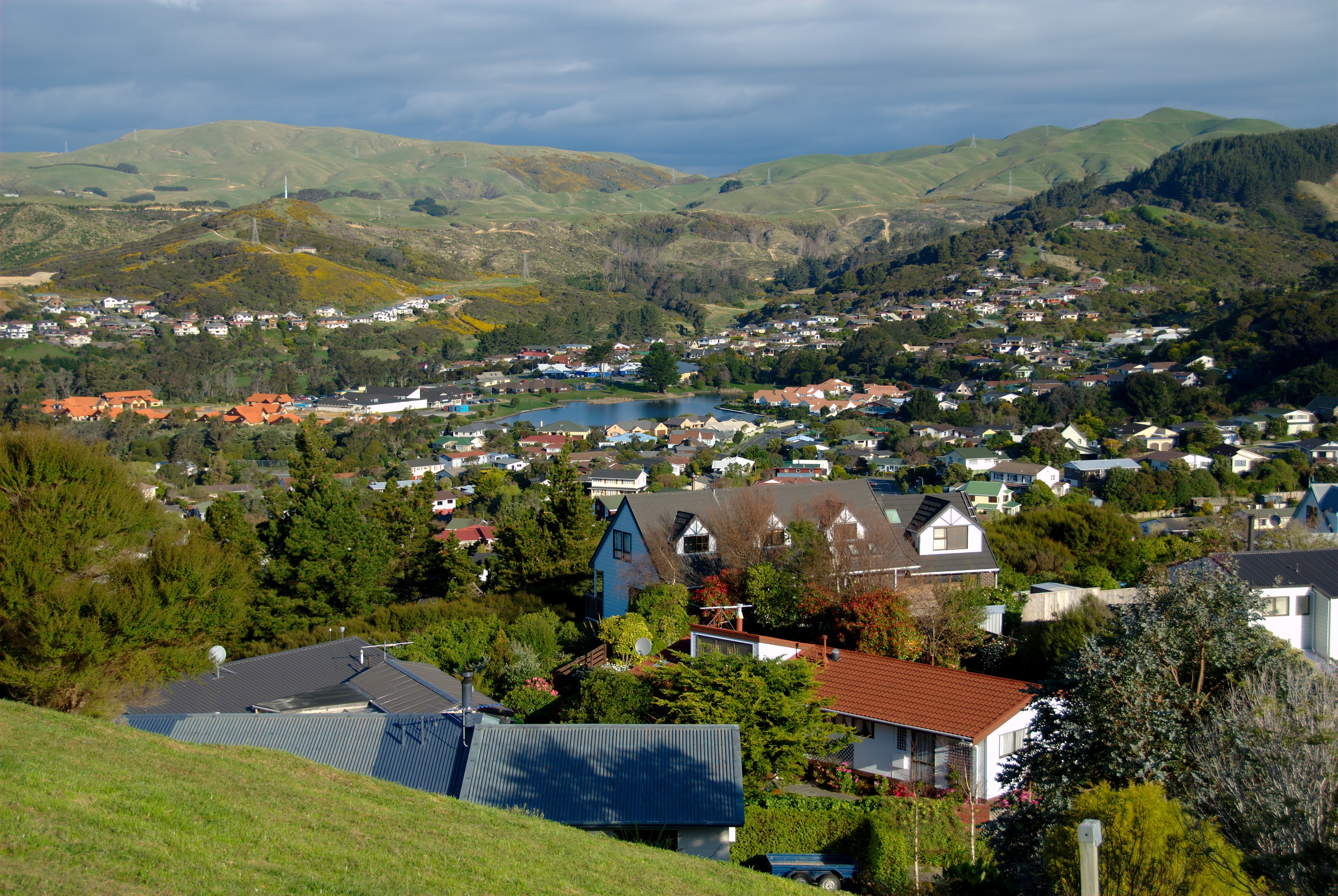
Whitby, a large suburb of Porirua City, New Zealand, located along much of the southern shore of the Pauatahanui Inlet of Porirua Harbour, was comprehensively planned in the 1960s (when still in Hutt County) and it has been continuously developed since, with current landscaping and expansion in the hills behind the eastern part of Whitby to facilitate the future growth of the suburb.
The name of the suburb itself, as well as the nautical theme of neighbourhood and street names, are drawn from the life and career of the Pacific explorer James Cook. The bicentennial of his first (1769) visit to New Zealand occurred when the development of Whitby started.
The suburb is commercially centred on the Whitby Shopping Centre, containing almost all the retail businesses in Whitby.
History
In 1967 some 3,180 acres (1,290 ha) of farmland was purchased by a consortium for a new residential development, to be similar to North American new towns; with a population growing to 16,000 in four "neighbourhoods", each focussed on a primary school. Following a town planning appeal hearing in 1974 this became two "neighbourhoods", Adventure and Endeavour.
The first sections in the 01 subdivision were sold by auction in 1970. By May 1971 eight homes were occupied (5 Spinnaker Drive was first); and by 1972, 203 sections had been sold and 62 of the 117 houses built were occupied. By 1998 some 2000 houses had been built. The consortium developed a village centre and a golf course, and operated a commuter bus service from 1 February 1973. The New Zealand Institution of Engineers gave the development their 1978 Environmental Award for an engineering work exemplifying care for and consideration of environmental values.
The original area was part of the Horokiri riding of Hutt County, and some of the later land was in Porirua City. In 1988 the Local Government Commission decided that all of Whitby should come under the Porirua City Council. The Community Developments Consortium (originally Huapai Properties) had partners Fletcher Mainline, Jubilee Investments (part of the Todd Group) and the National Mutual Life Association.
Demographics
Whitby, comprising the statistical areas of Whitby, Postgate, Endeavour East and Endeavour West, covers 6.67 km2. It had an estimated population of as of with a population density of people per km2.
Whitby had a population of 11,799 in the 2023 New Zealand census, an increase of 1,389 people (13.3%) since the 2018 census, and an increase of 2,958 people (33.5%) since the 2013 census. There were 5,748 males, 5,994 females, and 57 people of other genders in 3,975 dwellings. 3.3% of people identified as LGBTIQ+. The median age was 38.2 years (compared with 38.1 years nationally). There were 2,574 people (21.8%) aged under 15 years, 1,917 (16.2%) aged 15 to 29, 5,751 (48.7%) aged 30 to 64, and 1,557 (13.2%) aged 65 or older.
People could identify as more than one ethnicity. The results were 79.5% European (Pākehā); 12.0% Māori; 9.3% Pasifika; 12.2% Asian; 1.3% Middle Eastern, Latin American and African New Zealanders (MELAA); and 2.7% other, which includes people giving their ethnicity as "New Zealander". English was spoken by 96.2%, Māori by 2.7%, Samoan by 2.5%, and other languages by 15.0%. No language could be spoken by 2.7% (e.g. too young to talk). New Zealand Sign Language was known by 0.8%. The percentage of people born overseas was 28.2, compared with 28.8% nationally.
Religious affiliations were 33.2% Christian, 2.8% Hindu, 0.8% Islam, 0.4% Māori religious beliefs, 1.2% Buddhist, 0.3% New Age, 0.2% Jewish, and 1.8% other religions. People who answered that they had no religion were 53.3%, and 6.2% of people did not answer the census question.
Of those at least 15 years old, 3,216 (34.9%) people had a bachelor's or higher degree, 4,707 (51.0%) had a post-high school certificate or diploma, and 1,296 (14.0%) people exclusively held high school qualifications. The median income was $62,100, compared with $41,500 nationally. 2,448 people (26.5%) earned over $100,000 compared to 12.1% nationally. The employment status of those at least 15 was 5,673 (61.5%) full-time, 1,182 (12.8%) part-time, and 180 (2.0%) unemployed.
| Name | Area | |||||||
|---|---|---|---|---|---|---|---|---|
| (km2) | Population | Density | ||||||
| (per km2) | Dwellings | Median age | Median | |||||
| income | New Zealand | 38.1 years | $41,500 | |||||
| Postgate | 1.59 | 3,111 | 1,957 | 1,050 | 34.1 years | $57,900 | ||
| Whitby | 1.74 | 2,904 | 1,669 | 1,044 | 41.5 years | $56,400 | ||
| Endeavour West | 1.43 | 2,790 | 1,951 | 900 | 37.2 years | $71,300 | ||
| Endeavour East | 1.90 | 2,994 | 1,576 | 978 | 41.3 years | $66,800 |
Public transport
Buses servicing the area;
Number 230
Runs between The Crowsnest (Whitby) and Porirua railway station (Porirua), stopping at following stops (among others);
- The Crowsnest
- Spinnaker Drive at Hicks Close
- Aotea College opposite Okowai Road
- Porirua Station - Stop B
Number 236
Runs Between Navigation Drive (Whitby) and Porirua railway station (Porirua), stopping at following stops (among others);
- Navigation Drive
- Whitby Lakes (Upper Lake)
- Spinnaker Drive at Hicks Close
- Paremata Road (near 132)
- Paremata Station (bus stop)
- Oak Avenue (opposite 10)
- RNZ Police College - Papakowhai Road
- Porirua Station - Stop B
Education
Primary schools
Postgate School is a co-educational state primary school for Year 1 to 8 students, with a roll of as of . It is located within the smallest statistical area of Whitby, Postgate. It opened in 1981.
Adventure School is a co-educational state primary school for Year 1 to 8 students, with a roll of . It is located within the statistical area of West Endeavour. It opened in 1989.
Discovery School is a co-educational state primary school for Year 1 to 8 students, with a roll of 504. It is located within the suburb's centremost statistical area of Whitby. It opened in 1976.
Whitby Collegiate
Whitby Collegiate is a co-educational private secondary school for Year 7 to 13 students, with a roll of as of .
Whitby Independent College was founded in January 2004 by David Bradford, CEO and owner of Whitby Coastal Estates Ltd. The company had recently closed the Duck Creek Golf Course that it owned. It was decided to redesign and convert the clubhouse and proshop for the first 4 classrooms and administration. The project was designed by Gina Jones of Accent Architects.
Whitby Independent was the Wellington region's first new independent secondary school in 100 years. The college was initially managed by Anita Baker, a senior executive of Whitby Coastal Estates Ltd. Anita later became Mayor of Porirua City.
3 years later the school was purchased by Samuel Marsden Collegiate School and renamed Samuel Marsden Collegiate Whitby. A new classroom block was completed in mid-2007 which includes a large art room.
On 1 July 2019 Samuel Marsden Collegiate School Trust Board announced it had made the decision to close Marsden School Whitby at the end of the 2019 school year. On 9 August 2019 Fiso Group Ltd announced plans to acquire the school. The sale of Marsden Whitby to Fiso Investment Group Ltd was finalised on 10 December 2019. The school became Whitby Collegiate at the start of the 2020 academic year.
Other education
Preschool education is available from Discovery Kindergarten, Adventure Kindergarten and Mana Montessori Preschool.
The nearest public secondary school is Aotea College in Aotea.
References
References
- ''Whitby: The Making of a Community'' by Jennifer Brice (1998, Community Developments Consortium)
- "Stats NZ Geographic Data Service".
- {{NZ census 2018. Postgate (240200), Whitby (240400) and Endeavour (240600)
- "Totals by topic for dwellings, (RC, TALB, UR, SA3, SA2, Ward, Health), 2013, 2018, and 2023 Censuses". Stats NZ – Tatauranga Aotearoa – Aotearoa Data Explorer.
- "Totals by topic for individuals, (RC, TALB, UR, SA3, SA2, Ward, Health), 2013, 2018, and 2023 Censuses". Stats NZ – Tatauranga Aotearoa – Aotearoa Data Explorer.
- "Totals by topic for individuals, (RC, TALB, UR, SA3, SA2, Ward, Health), 2013, 2018, and 2023 Censuses". Stats NZ - Tatauranga Aotearoa - Aotearoa Data Explorer.
- "Totals by topic for individuals, (RC, TALB, UR, SA3, SA2, Ward, Health), 2013, 2018, and 2023 Censuses". Stats NZ - Tatauranga Aotearoa - Aotearoa Data Explorer.
- "Totals by topic for individuals, (RC, TALB, UR, SA3, SA2, Ward, Health), 2013, 2018, and 2023 Censuses". Stats NZ - Tatauranga Aotearoa - Aotearoa Data Explorer.
- "Totals by topic for individuals, (RC, TALB, UR, SA3, SA2, Ward, Health), 2013, 2018, and 2023 Censuses". Stats NZ - Tatauranga Aotearoa - Aotearoa Data Explorer.
- [http://www.metlink.co.nz MetLink]
- "Whitby (The Crowsnest) - Aotea - Porirua - Metlink".
- "Whitby (Navigation Drive) - Paremata - Papakowhai - Porirua".
- "Postgate School Official School Website".
- "Postgate School Education Review Office Report". [[Education Review Office]].
- "Postgate School Ministry of Education School Profile". [[Ministry of Education (New Zealand).
- Dando, Kris. (29 March 2011). "End of an era as principal leaves Postgate School in Porirua after 25 years". [[Dominion Post (New Zealand).
- "Adventure School Official School Website".
- "Adventure School Education Review Office Report". [[Education Review Office]].
- "Adventure School Ministry of Education School Profile". [[Ministry of Education (New Zealand).
- "Our School". Adventure School.
- "Our School". Discovery School.
- "Whitby Collegiate Education Review Office Report". [[Education Review Office]].
- "Whitby Collegiate Ministry of Education School Profile". [[Ministry of Education (New Zealand).
- "Samuel Marsden Collegiate School Official School Website".
- "Whitby School's Future".
- "Whitby Collegiate Official School Website".
- "Kindergartens in the Porirua Region".
- "Find schools in Porirua City". [[Ministry of Education (New Zealand).
This article was imported from Wikipedia and is available under the Creative Commons Attribution-ShareAlike 4.0 License. Content has been adapted to SurfDoc format. Original contributors can be found on the article history page.
Ask Mako anything about Whitby, New Zealand — get instant answers, deeper analysis, and related topics.
Research with MakoFree with your Surf account
Create a free account to save articles, ask Mako questions, and organize your research.
Sign up freeThis content may have been generated or modified by AI. CloudSurf Software LLC is not responsible for the accuracy, completeness, or reliability of AI-generated content. Always verify important information from primary sources.
Report