From Surf Wiki (app.surf) — the open knowledge base
Westminster, Colorado
Home rule city in Adams and Jefferson counties, Colorado, United States
Home rule city in Adams and Jefferson counties, Colorado, United States
| Field | Value | ||||||||||||||
|---|---|---|---|---|---|---|---|---|---|---|---|---|---|---|---|
| name | Westminster, Colorado | ||||||||||||||
| official_name | City of Westminster | ||||||||||||||
| settlement_type | home rule city | ||||||||||||||
| image_skyline | Mountains viewed from Westminster.jpg | ||||||||||||||
| image_caption | Houses in Westminster with the Front Range in the background | ||||||||||||||
| image_flag | Flag of Westminster, Colorado.svg | ||||||||||||||
| flag_size | 150px | ||||||||||||||
| image_map | Adams County and Jefferson County Colorado Incorporated and Unincorporated areas Westminster Highlighted 0883835.svg | ||||||||||||||
| map_caption | Location of the City of Westminster in Adams and Jefferson counties, Colorado | ||||||||||||||
| pushpin_map | USA#USA Colorado | ||||||||||||||
| pushpin_relief | yes | ||||||||||||||
| pushpin_label | Westminster | ||||||||||||||
| pushpin_label_position | right | ||||||||||||||
| pushpin_map_caption | Location of the City of Westminster, Colorado. | ||||||||||||||
| coordinates | |||||||||||||||
| coordinates_footnotes | |||||||||||||||
| elevation_ft | 5381 | ||||||||||||||
| elevation_footnotes | |||||||||||||||
| subdivision_type | Country | ||||||||||||||
| subdivision_name | United States | ||||||||||||||
| subdivision_type1 | State | ||||||||||||||
| subdivision_name1 | Colorado | ||||||||||||||
| subdivision_type2 | Counties | ||||||||||||||
| subdivision_name2 | Adams and Jefferson | ||||||||||||||
| government_type | home rule city | ||||||||||||||
| leader_title | Mayor | ||||||||||||||
| leader_name | Claire Carmelia | ||||||||||||||
| leader_title2 | City Manager | ||||||||||||||
| leader_name2 | Jody Andrews | ||||||||||||||
| established_title | Settled | ||||||||||||||
| established_date | 1870 | ||||||||||||||
| established_title2 | Platted | ||||||||||||||
| established_date2 | 1885 as DeSpain Junction, later Harris | ||||||||||||||
| established_title3 | Incorporated | ||||||||||||||
| established_date3 | April 4, 1911, as the Town of Westminster | ||||||||||||||
| unit_pref | US | ||||||||||||||
| total_type | Total | ||||||||||||||
| area_footnotes | |||||||||||||||
| area_total_km2 | 87.796 | ||||||||||||||
| area_land_km2 | 81.806 | ||||||||||||||
| area_water_km2 | 5.990 | ||||||||||||||
| population_as_of | 2020 | ||||||||||||||
| population_footnotes | |||||||||||||||
| population_total | 116,317 | ||||||||||||||
| population_rank | 8th in Colorado | ||||||||||||||
| 250th in the United States | |||||||||||||||
| population_density_sq_mi | 3,683 | ||||||||||||||
| population_metro | 2,963,821 (19th) | ||||||||||||||
| population_blank1_title | CSA | ||||||||||||||
| population_blank1 | 3,623,560 (17th) | ||||||||||||||
| population_blank2_title | Front Range | ||||||||||||||
| population_blank2 | 5,055,344 | ||||||||||||||
| timezone | MST | ||||||||||||||
| utc_offset | −07:00 | ||||||||||||||
| timezone_DST | MDT | ||||||||||||||
| utc_offset_DST | −06:00 | ||||||||||||||
| postal_code_type | ZIP codes | ||||||||||||||
| postal_code | 80003, 80005, 80020-80021, 80023, 80030-80031, 80035-80036, 80221, 80234, 80241, 80260 | ||||||||||||||
| area_code_type | Area codes | ||||||||||||||
| area_code | 303/720/983 | ||||||||||||||
| blank_name | GNIS place ID | ||||||||||||||
| blank_info | |||||||||||||||
| blank1_name | GNIS town ID | ||||||||||||||
| blank1_info | |||||||||||||||
| blank2_name | FIPS code | ||||||||||||||
| blank2_info | |||||||||||||||
| blank3_name | Major highways | ||||||||||||||
| blank3_info | [[File:I-25 (CO).svg | 24px | link=Interstate 25 in Colorado]] [[File:US_36.svg | 24px | link=U.S. Route 36 in Colorado]] [[File:US_87.svg | 24px | link=U.S. Route 87 in Colorado]] [[File:US_287.svg | 24px | link=U.S. Route 287 in Colorado]] [[File:Colorado_95.svg | 24px | link=Colorado State Highway 95]] [[File:Colorado_121.svg | 24px | link=Colorado State Highway 121]] [[File:Colorado_128.svg | 24px | link=Colorado State Highway 128]] |
| website |
250th in the United States
Westminster is a home rule city located in Adams and Jefferson counties, Colorado, United States. The city population was 116,317 at the 2020 United States census with 71,240 residing in Adams County and 45,077 residing in Jefferson County. Westminster is the eighth most populous city in Colorado. The city is a part of the Denver-Aurora-Centennial, CO Metropolitan Statistical Area and the Front Range Urban Corridor. The Westminster Municipal Center is located 9 mi north-northwest of the Colorado State Capitol in Denver.
History
Westminsters' first permanent settler was Kentucky farmer Pleasant DeSpain, who built his home in 1870 on 160 acres (near what is now West 76th Avenue and Lowell Street). The area became known as DeSpain Junction and attracted other settlers including Edward Bruce Bowles, who in 1881 constructed a brick Italianate house now known as the Bowles House. It was listed on the National Register of Historic Places in 1988. The village of DeSpain Junction grew into a small farming community and continued to attract new settlers despite the difficulty of farming in Colorado's arid climate.
Connecticut real estate developer C.J. Harris arrived in DeSpain Junction in 1885 and purchased the DeSpain farm, among others. Harris combined the separate homesteads and divided it into smaller tracts of land, which he sold to fruit farmers. Harris renamed DeSpain Junction with his own name and the area was referred to as Harris, Colorado. The Harris, Colorado, post office opened on June 5, 1908, although much of the area of future city was served by the Denver, Colorado, post office.
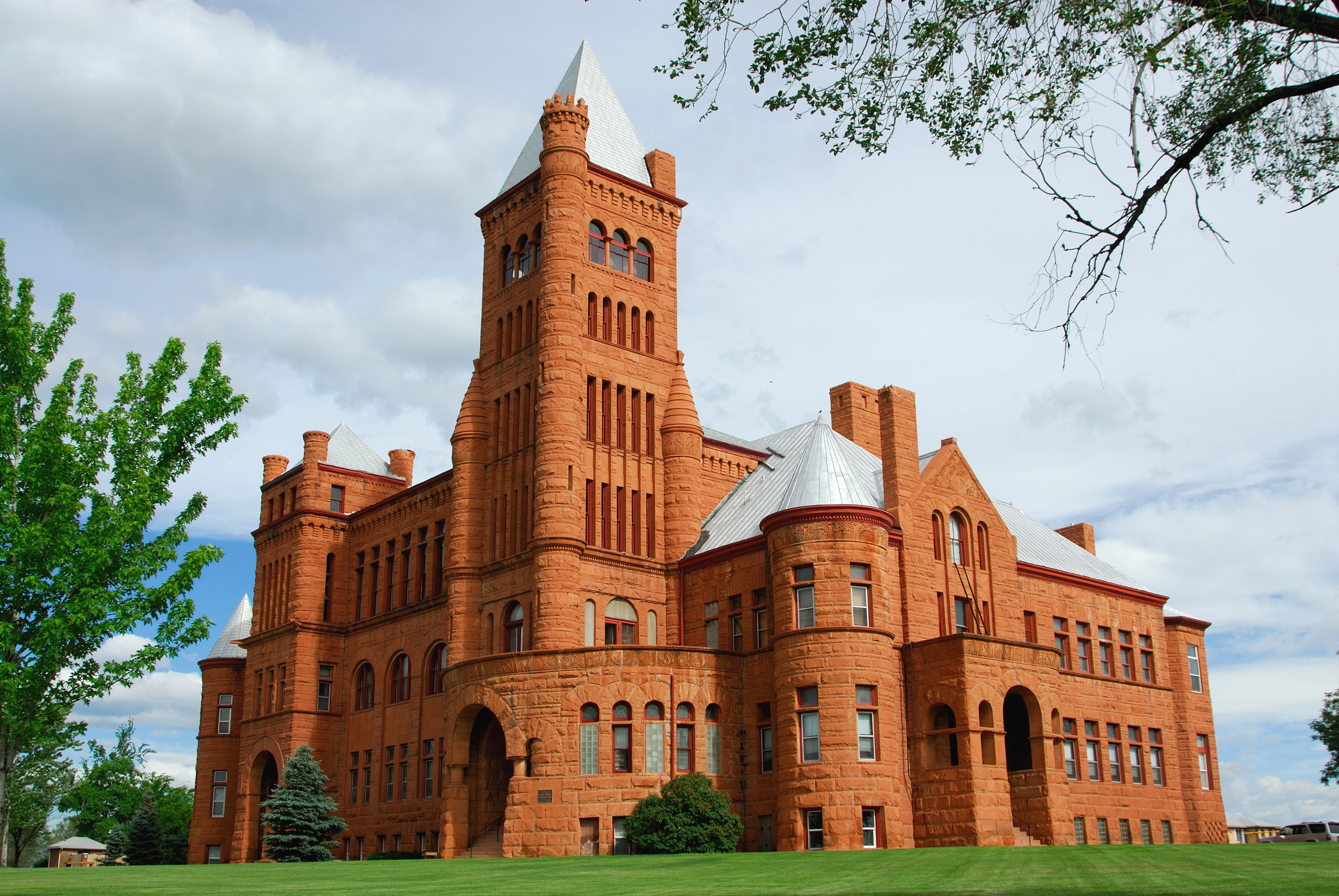
In 1890, New Yorker Henry T. Mayham convinced the Denver Presbytery to build a university on land that he owned in Harris. After delays caused by the depression of 1893, the school was built from red sandstone quarried in Colorado's Red Rocks region. The curriculum was patterned after Princeton University and was referred to as the "Princeton of the West". The school was incorporated as Westminster University of Colorado, and classes began in 1908 with one year's tuition costing $50 ($1,411 in 2018). The Harris post office was renamed Westminster on June 5, 1908, In the following decade it operated as a church and school. The former Westminster University is now on the National Register of Historic Places.
In July 2006, Westminster was ranked as the 24th best place to live in the US by Money magazine.
Bell Tower
Westminster City Hall features a 14-story bell tower topped by a pyramid shaped steel mesh structure. The 130-foot spire, which is widely known and referenced as a community landmark, was first conceptualized as a symbolic tie and tribute to the clock tower of Westminster Palace in England known as Big Ben. The unveiling of the Bell Tower in 1986 was attended by the then mayor of Westminster, England. An English Oak can be seen on the City Hall property today- a gift to Westminster, Colorado, from Westminster, England.
Geography
Westminster is located in western Adams County and northeastern Jefferson County. It is bordered to the north by Broomfield, to the northeast by Thornton, to the east by Northglenn and Federal Heights, to the southeast by Sherrelwood, Twin Lakes and Berkley, and to the south by Arvada.
At the 2020 United States census, the town had a total area of 87.796 km2 including 5.990 km2 of water.

Demographics
2020 census
| Race / Ethnicity (NH = Non-Hispanic) | title=P004 Hispanic or Latino, and Not Hispanic or Latino by Race – 2000: DEC Summary File 1 – Westminster city, Colorado | url=https://data.census.gov/table/DECENNIALSF12000.P004?g=160XX00US0883835 | website=United States Census Bureau}} | title=P2 Hispanic or Latino, and Not Hispanic or Latino by Race – 2010: DEC Redistricting Data (PL 94-171) – Westminster city, Colorado | url=https://data.census.gov/cedsci/table?q=p2&g=160XX00US0883835&tid=DECENNIALPL2010.P2 | website=United States Census Bureau}} | % 2000 | % 2010 |
|---|---|---|---|---|---|---|---|---|
| White alone (NH) | 76,637 | 74,447 | 74,502 | 75.92% | ||||
| Black or African American alone (NH) | 1,149 | 1,360 | 1,805 | 1.14% | ||||
| Native American or Alaska Native alone (NH) | 466 | 470 | 576 | 0.46% | ||||
| Asian alone (NH) | 5,479 | 5,650 | 6,372 | 5.43% | ||||
| Pacific Islander alone (NH) | 53 | 82 | 80 | 0.05% | ||||
| Some Other Race alone (NH) | 71 | 175 | 503 | 0.07% | ||||
| Mixed Race or Multi-Racial (NH) | 1,716 | 1,924 | 5,241 | 1.70% | ||||
| Hispanic or Latino (any race) | 15,369 | 22,006 | 27,238 | 15.23% | ||||
| Total | 100,940 | 106,114 | 116,317 | 100.00% |
As of the census of 2000, there were 100,940 people, 38,343 households, and 26,034 families residing in the city. The population density was 3,203.9 PD/sqmi. There were 39,318 housing units at an average density of 1,248.0 /mi2. The racial makeup of the city was 84.19% White, 1.23% African American, 0.74% Native American, 5.48% Asian, 0.08% Pacific Islander, 5.52% from other races, and 2.76% from two or more races. Hispanic or Latino of any race were 15.23% of the population.
There were 38,343 households, out of which 35.7% had children under the age of 18 living with them, 53.6% were married couples living together, 9.6% had a female householder with no husband present, and 32.1% were non-families. 23.7% of all households were made up of individuals, and 4.5% had someone living alone who was 65 years of age or older. The average household size was 2.62 and the average family size was 3.15.
In the city, the population was spread out, with 26.9% under the age of 18, 9.6% from 18 to 24, 36.0% from 25 to 44, 21.0% from 45 to 64, and 6.5% who were 65 years of age or older. The median age was 33 years. For every 100 females, there were 100.2 males. For every 100 females age 18 and over, there were 98.9 males.
The median income for a household in the city was $56,323, and the median income for a family was $63,776. Males had a median income of $41,539 versus $31,568 for females. The per capita income for the city was $25,482. About 3.1% of families and 4.7% of the population were below the poverty line, including 5.1% of those under age 18 and 6.3% of those age 65 or over.
Transportation
Westminster is intersected by several state highways: I-25, US 36, US 287, SH 95, SH 121, and SH 128.
The Denver Regional Transportation District (RTD) provides bus service to Westminster connecting it to Boulder and Denver via Flatiron Flyer, a bus rapid transit service that travels in the US 36 express lanes.
The Westminster Center park-n-Ride operated by the RTD is located on both sides of U.S. 36 and is immediately across Sheridan Boulevard from the site. Approximately 1,546 people per weekday board at this facility, with approximately 498 buses per day serving this park-n-Ride.
RTD opened the B Line to the public in 2016 which brings commuter rail service between downtown Denver and Westminster Station. The 6 miles of commuter rail transports riders from the historic center of Westminster to the dynamic Union Station Transit Center where they can connect to the C/D, E, and W light rail lines, the A Line to Denver International Airport, as well as Local and Regional buses, and the FreeMallRide and FreeMetroRide downtown shuttles.
Westminster is served by Denver International Airport and nearby Rocky Mountain Metropolitan Airport.
Economy
Companies based in Westminster include Vantor, Ball and the Western Fuels Association.
Top employers
Westminster's top employers represent leading companies in high-tech, medical, energy, and other expanding fields. As of 2019 the top ten primary employers in Westminster, ranked by number of employees, included:
| Rank | Employer | # of Employees |
|---|---|---|
| 1 | Ball Corporation | 1,252 |
| 2 | Maxar | 1,071 |
| 3 | St. Anthony's North Hospital | 1,015 |
| 4 | Trimble Navigation | 733 |
| 5 | Alliance Data Systems | 677 |
| 6 | Tri-State Generation and Transmission Association | 541 |
| 7 | MTech Mechanical Technologies Group | 600 |
| 8 | ReedGroup | 496 |
| 9 | Epsilon | 454 |
| 10 | CACI International | 407 |
Education
High schools in or near Westminster include the Academy of Charter Schools, Hidden Lake High School, Jefferson Academy High School, Legacy High School, Mountain Range High School, Northglenn High School, Pomona High School, Standley Lake High School, and Westminster High School. In 2010 Adams County School District 50 opened a new Westminster High School replacing both the existing Westminster High School and Ranum High School, which graduated its last class that year.
Shepherd of the Valley Lutheran School is a pre-k3 through 8th grade Christian school of the Wisconsin Evangelical Lutheran Synod in Westminster.
Open space
Westminster has an extensive trail network and open space system. The highlight of the trail system is the Big Dry Creek Trail which extends approximately 12 mi from the eastern boundary of the city to Standley Lake. Other trails parallel the Farmers' High Line Canal, Walnut Creek, and Little Dry Creek.
Westminster began preserving open spaces in 1985 when voters first approved a sales tax specifically earmarked to acquire and maintain open space. The city now owns more than 3,000 acres in all parts of Westminster. The city has preserved large expanses of land in the Standley Lake Regional Park , and the Westminster Hills area, among others. Westminster City Park, City Park Recreation Center , and many other neighborhood and community parks provide various recreation facilities. Westminster has several golf courses, including Legacy Ridge Golf Course, The Heritage Golf Course at Westmoor, Walnut Creek Golf Course and the Hyland Hills golf course.
Downtown Westminster intersects directly with the new U.S. 36 Bikeway linking the largest trail system in the Front Range with over 145 miles.
Retail
Westminster is home to The Orchard Town Center, an outdoor mall featuring over 90 speciality retailers, dining and entertainment located at the intersection of I-25 and 144th Avenue.
The city's major mall had previously been the Westminster Mall, demolished in 2012 to make way for the Downtown Westminster development.
Downtown Westminster
Downtown Westminster is a 105 acre site almost equidistant between downtown Denver and Boulder. The new downtown will feature 18 acres of parks and public space. It integrates Smart City functionality to reduce consumption of water and energy and will have smart streetlights, parking garages, and meters. Development began with the completion of over 300 housing units, including 118 affordable housing units. Downtown Westminster features an Alamo Drafthouse Cinema and a 125-room boutique hotel, the Origin Hotel.
Downtown Westminster is planned to house 300 hotel rooms, 2,300 multi-family, condo and townhouse residential units, 2 e6sqft of collaborative and class A office space, and 750,000 ft2 of retail space.
Notable people
Main article: List of people from Westminster, Colorado
Notable individuals who were born in or have lived in Westminster include figure skater Mariah Bell, Texas newspaper publisher Frank Willis Mayborn, and silent film actor Pete Morrison.
References
References
- "Active Colorado Municipalities". [[Colorado Department of Local Affairs]].
- {{cite gnis
- "Colorado Counties". [[Colorado Department of Local Affairs]].
- (August 12, 2021). "Decennial Census P.L. 94-171 Redistricting Data". [[United States Census Bureau]], [[United States Department of Commerce]].
- "ZIP Code Lookup". [[United States Postal Service]].
- "The Early Settlers".
- "The Early Settlers". City of Westminster.
- (December 24, 2011). "On History: Despain Junction was spot of early life in area".
- (1990). "Colorado Post Offices 1859–1989". [[Colorado Railroad Museum.
- "The Inflation Calculator". Morgan Friedman.
- "The Princeton of the West".
- "MONEY Magazine: Best places to live 2006: Top 100 1-25". CNN.
- "Bell Tower".
- "US Census Bureau City and Town Population Totals: 2020-2024". United States Census Bureau.
- "P004 Hispanic or Latino, and Not Hispanic or Latino by Race – 2000: DEC Summary File 1 – Westminster city, Colorado".
- "P2 Hispanic or Latino, and Not Hispanic or Latino by Race – 2010: DEC Redistricting Data (PL 94-171) – Westminster city, Colorado".
- "P2 Hispanic or Latino, and Not Hispanic or Latino by Race – 2020: DEC Redistricting Data (PL 94-171) – Westminster city, Colorado".
- "U.S. Census website". [[United States Census Bureau]].
- "Flatiron Flyer".
- "Downtown Westminster - The Next Urban Center on Colorado's Front Range".
- "2015 Fact Sheet".
- "Leading Employers".
- "City of Westminster > Explore Westminster > Schools".
- Whaley, Monte. "New Westminster High set to open with new teaching approach". Denver Post.
- "WELCOME TO SHEPHERD OF THE VALLEY".
- (August 26, 2017). "Downtown Westminster breaks ground on 1.2-acre Central Plaza".
- "Open Space - City of Westminster, Colorado".
- "DOWNTOWN WESTMINSTER".
- "Downtown Westminster - City of Westminster Economic Development".
- (July 22, 2019). "First Affordable Component at Westminster Mall Redevelopment Complete".
- "Downtown Westminster - A Hub of Activity".
- "Mariah Bell". Ice Network.
- "Mayborn, Frank Willis". Texas State Historical Association.
- "Morrison, George D.". Golden History Museums.
This article was imported from Wikipedia and is available under the Creative Commons Attribution-ShareAlike 4.0 License. Content has been adapted to SurfDoc format. Original contributors can be found on the article history page.
Ask Mako anything about Westminster, Colorado — get instant answers, deeper analysis, and related topics.
Research with MakoFree with your Surf account
Create a free account to save articles, ask Mako questions, and organize your research.
Sign up freeThis content may have been generated or modified by AI. CloudSurf Software LLC is not responsible for the accuracy, completeness, or reliability of AI-generated content. Always verify important information from primary sources.
Report