From Surf Wiki (app.surf) — the open knowledge base
West Midlands conurbation

| Field | Value | |
|---|---|---|
| name | West Midlands | |
| other_name | ||
| settlement_type | Conurbation | |
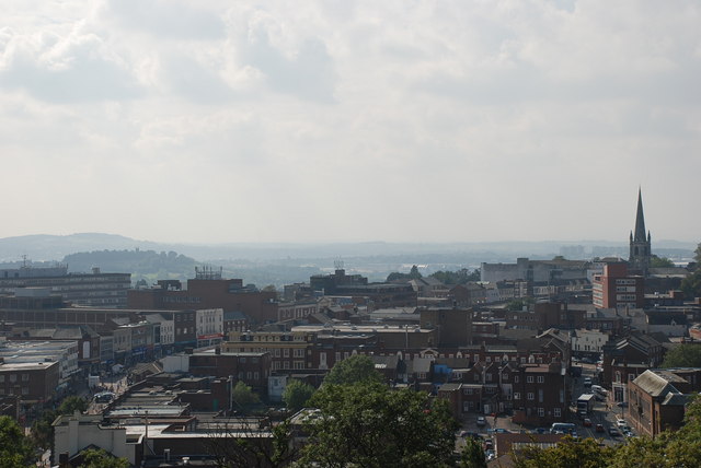
| image_skyline | {{multiple image | |
| border | infobox | |
| perrow | 2 | |
| total_width | 250 | |
| image1 | Big Brum and Chamberlain Memorial, Chamberlain Square, Birmingham - geograph.org.uk - 3814523.jpg | |
| image2 | Market Place, Wolverhampton - geograph.org.uk - 3815661.jpg | |
| image3 | Dudley Town Centre.jpg | |
| image4 | West Bromwich Town Hall.jpg | |
| image5 | High Street, Solihull - geograph.org.uk - 4213860.jpg | |
| image6 | Streets of the town 3 - Walsall, West Midlands - geograph.org.uk - 4514940.jpg | |
| image_caption | ||
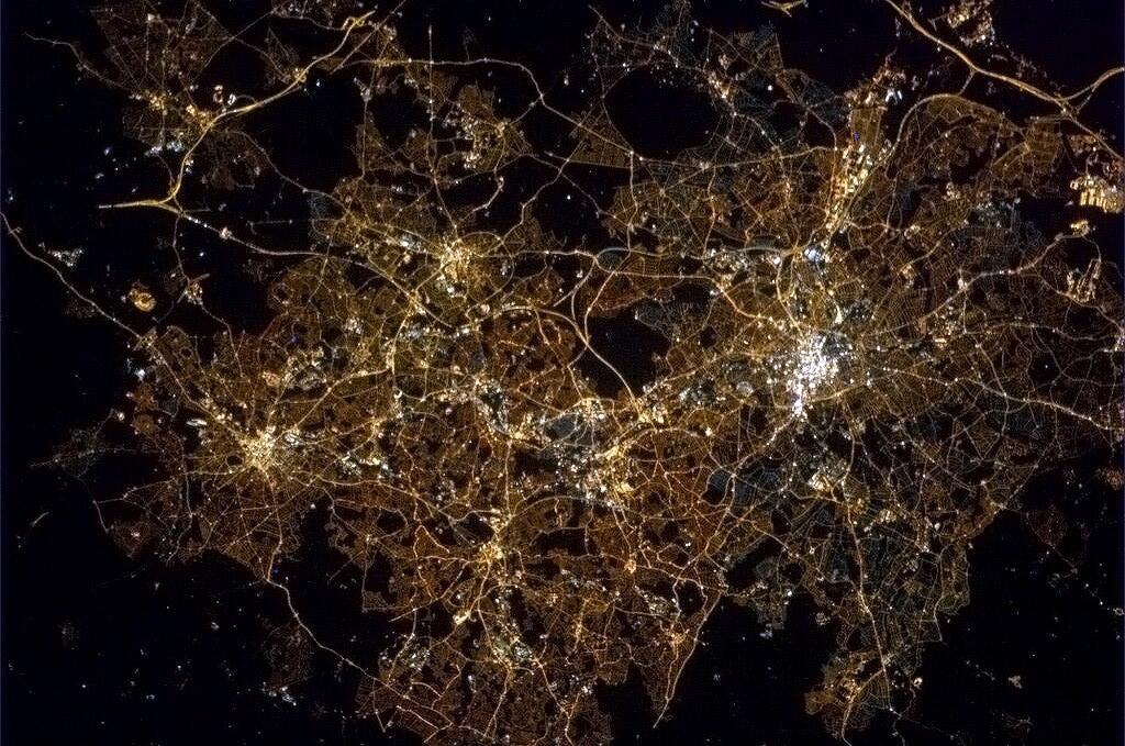
| image_map | West Midlands BUA 2011 with TTWA overlay.png | |
| mapsize | 250px | |
| map_caption | Map of the West Midlands conurbation in 2011, with Travel to Work Areas overlaid. The five most populous are highlighted with Birmingham and Wolverhampton sub-divisions in orange and the Dudley, Walsall and Solihull sub-divisions in green. | |
| <!-- location ------------------> | subdivision_type | Sovereign state |
| subdivision_name | United Kingdom | |
| subdivision_type1 | Constituent country | |
| subdivision_name1 | England | |
| <!-- seat, smaller parts -------> | parts_type | Largest settlements |
| parts_style | list | |
| parts | (Pop. 100,000+) | |
| p1 | Birmingham | |
| p2 | Dudley | |
| p3 | Solihull | |
| p4 | Sandwell | |
| p5 | Wolverhampton | |
| p6 | ||
| unit_pref | ||
| <!-- area ----------------------> | area_total_km2 | |
| area_total_sq_mi | ||
| area_water_acre | ||
| elevation_footnotes | ||
| elevation_max_footnotes | ||
| elevation_min_footnotes | ||
| elevation_min_ft | ||
| population_total | 2,440,986 | |
| population_as_of | 2011 census | |
| population_rank | 3rd | |
| population_density_km2 | ||
| population_density_sq_mi | ||
| timezone1 | GMT | |
| utc_offset1 | +0 | |
| timezone1_DST | BST | |
| utc_offset1_DST | +1 | |
| <!-- postal codes, area code ---> | postal_code_type | Postcode |
| postal_code | B, DY, WS, WV | |
| area_code_type | ||
| area_codes | 0121, 01543, 01562, 01384, 01902, 01922 |
The West Midlands conurbation is the large conurbation in the West Midlands region of England. The area consists of two cities and numerous towns: to the east, the city of Birmingham, along with adjacent towns of Solihull and Sutton Coldfield; and to the west, the city of Wolverhampton and the area called the Black Country, containing the towns of Dudley, Walsall, West Bromwich, Oldbury, Willenhall, Bilston, Darlaston, Tipton, Smethwick, Wednesbury, Rowley Regis, Stourbridge and Halesowen.
It is broken down into multiple Travel to Work Areas: Birmingham, Wolverhampton, Dudley & Sandwell, Walsall & Cannock, Hagley is within the Kidderminster area and the extreme south-east corner is within the Warwick & Stratford upon Avon area. The conurbation is mainly in the West Midlands county, including parts of the surrounding counties of Staffordshire (e.g. Little Aston, Perton and Essington) and Worcestershire (such as Hagley and Hollywood), with Coventry a separate area in the county.
According to the 2011 Census the area had a population of 2,440,986, making it the third most populated in the United Kingdom behind Greater London and Greater Manchester.
With the West Midlands also being a region and county, the conurbation is sometimes known as Birmingham-Wolverhampton. though it is the term Birmingham & The Black Country that has gained the widest traction as an alternative to the conurbation's official name: an example of this is the tagline used by BBC Radio WM - "The sound of Birmingham & The Black Country".
Constituent parts
Although the exact boundaries of any conurbation are open to debate, dependent on what criteria are used to determine where an urban area ceases, the Office for National Statistics defines the West Midlands Built Up Area as including the urban areas of Birmingham, Wolverhampton, Solihull, West Bromwich, Dudley, and Walsall amongst others. These settlements are not coterminous with the Metropolitan Boroughs of the same name.
Coventry is separated from the West Midlands conurbation by the Meriden Gap, and other urban areas, such as Cannock and Codsall remain separate from the conurbation. Coventry is 19 miles east of Birmingham.


Administration
Occasionally the conurbation is seen as being coterminous with the West Midlands Metropolitan county; however, this includes Coventry, which is separate from the main urban area, and excludes the parts of the surrounding counties of Staffordshire, Warwickshire and Worcestershire that fall within the conurbation.
For administrative purposes, the vast majority of the conurbation falls within the six Metropolitan Boroughs of Birmingham, Dudley, Sandwell, Solihull, Walsall and Wolverhampton.
Two Local enterprise partnerships (LEPs) cover the majority of the conurbation area: Black Country LEP comprises the local authorities of Dudley, Sandwell, Walsall and Wolverhampton while the Greater Birmingham & Solihull LEP includes those two authorities and a number of satellite boroughs, many remote from the conurbation and not traditionally associated with it (Bromsgrove, Cannock Chase, East Staffordshire, Lichfield, Redditch, Tamworth and Wyre Forest).
Settlements
2011 Census
The West Midlands Built Up Area consists of the below subdivisions. Due to the change in methodology between the 2001 and 2011 Census, and the amount of change between 2011 Census and previous census data, it is impossible to compare the data directly between 2011 and earlier Censuses.
| Rank | Settlement | Population (2011) |
|---|---|---|
| Notes on significant changes since 2001 | ||
| 1 | Birmingham | 1,085,810 |
| 2 | Wolverhampton | 210,319 |
| 3 | Solihull | 123,187 |
| 4 | Sutton Coldfield | 95,107 |
| 5 | Dudley | 79,379 |
| 6 | West Bromwich | 72,945 |
| 7 | Walsall | 67,594 |
| 8 | Stourbridge | 63,298 |
| 9 | Halesowen | 58,135 |
| 10 | Willenhall | 51,429 |
| 11 | Kingswinford | 50,801 |
| 12 | Smethwick | 48,765 |
| 13 | Bloxwich | 47,288 |
| 13 | Tipton | 42,407 |
| 14 | Aldridge | 39,463 |
| 15 | Rowley Regis | 34,260 |
| 16 | Brierley Hill | 31,430 |
| 17 | Sedgley | 30,979 |
| 18 | Bilston | 29,556 |
| 19 | Wednesfield | 25,303 |
| 20 | Oldbury | 23,964 |
| 21 | Coseley | 23,104 |
| 22 | Brownhills | 20,373 |
| 23 | Wednesbury | 19,029 |
| 24 | West Bromwich East | 18,985 |
| 25 | Darlaston | 18,803 |
| 26 | Blackheath | 6,518 |
| 27 | Cheswick Green | 2,197 |
| 28 | Wythall | 1,912 |
| 29 | Hampton in Arden | 1,678 |
| 30 | Stonnall | 1,338 |
| 31 | Major's Green | 1,002 |
| 32 | Tidbury Green | 720 |
In the 2011 Census, Coleshill and Water Orton are two separate built-up areas with populations of 6,341 and 3,444 respectively. Prior to 2011, they were considered part of the West Midlands Urban Area.
Prior censuses
Prior to the 2011 census, the conurbation was known by the ONS as the West Midlands Urban Area, which contained the following Urban Sub-Divisions:
| Rank | Settlement | Population | Population | Population |
|---|---|---|---|---|
| 1 | Birmingham | 970,892 | 965,928 | 1,024,118 |
| 2 | Wolverhampton | 251,462 | 257,943 | 265,631 |
| 3 | Dudley | 194,919 | 192,171 | 187,367 |
| 4 | Walsall | 170,994 | 174,739 | 178,852 |
| 5 | Oldbury / Smethwick | 139,855 | 145,542 | 153,461 |
| 6 | West Bromwich | 136,940 | 146,386 | 154,531 |
| 7 | Sutton Coldfield | 105,452 | 106,001 | 103,097 |
| 8 | Solihull | 94,753 | 94,531 | 94,613 |
| 9 | Stourbridge | 55,480 | 55,624 | 55,499 |
| 10 | Halesowen | 55,273 | 57,918 | 57,532 |
| 11 | Brownhills | 19,866 | 18,159 | 18,200 |
| 12 | Knowle / Bentley Heath | 18,452 | ||
| 13 | Aldridge | 15,659 | 16,832 | 17,589 |
| 14 | Pelsall | 10,524 | 10,007 | 10,328 |
| 15 | Shelfield | 6,807 | 7,079 | 6,029 |
| 16 | Coleshill | 6,235 | 6,324 | |
| 17 | Yew Tree | 6,109 | ||
| 18 | Rushall | 5,864 | 5,871 | 6,137 |
| 19 | Hagley | 5,723 | 5,417 | 5,754 |
| 20 | Shelly Green | 5,702 | ||
| 21 | Water Orton | 3,573 | 3,555 | |
| 22 | Cheswick Green | 2,261 | 2,511 | |
| 23 | Knowle | 17,588 | 16,872 | |
| 24 | Bentley Heath | 5,984 |
Notes:
- Knowle and Bentley Heath are considered as one settlement in 2001, but are considered separately in 1991 and 1981. Bentley Heath was not considered to be a settlement within the West Midlands Urban Area in 1981.
- Coleshill and Water Orton were not considered to be part of the West Midlands Urban Area in 1981, but a separate Coleshill/Water Orton Urban Area with a total population of 9,554; made up of Coleshill (6,113) and Water Orton (3,441).
- Yew Tree is only considered part of the West Midlands Urban Area in the 2001 census.
- Cheswick Green was not considered to be a settlement within the West Midlands Urban Area in 1981.
- Shelly Green was not considered to be a settlement within the West Midlands Urban Area in 1981 or 1991.
References
References
- "2011 Census - Built-up areas". [[Office for National Statistics.
- (1985). "Politics and Method: Contrasting Studies in Industrial Geography". Taylor & Francis.
- (2013). "143 (West Midlands) Brigade". British Army.
- Goode, David. (2010). "The Routledge Handbook of Urban Ecology". Routledge.
- (1982). "Accents of English 2: The British Isles". Cambridge University Press.
- (1976). "Grassed and Planted Areas by Motorways". The Institute of Terrestrial Ecology.
- (1972). "Geography Vol 57, number 2". Geographical Association.
- Whitehead, Mark. (2007). "Spaces of Sustainability: Geographical Perspectives on the Sustainable Society". Routledge.
- "2001 census: Key Statistics for Urban Areas". ONS.
- "1991 Census: West Midlands Urban Area". ONS.
- (1981). "1981 Key Statistics for Urban Areas: The Midlands Table 1". Office for National Statistics.
This article was imported from Wikipedia and is available under the Creative Commons Attribution-ShareAlike 4.0 License. Content has been adapted to SurfDoc format. Original contributors can be found on the article history page.
Ask Mako anything about West Midlands conurbation — get instant answers, deeper analysis, and related topics.
Research with MakoFree with your Surf account
Create a free account to save articles, ask Mako questions, and organize your research.
Sign up freeThis content may have been generated or modified by AI. CloudSurf Software LLC is not responsible for the accuracy, completeness, or reliability of AI-generated content. Always verify important information from primary sources.
Report