From Surf Wiki (app.surf) — the open knowledge base
West Hazleton, Pennsylvania
Borough in Pennsylvania, US
Borough in Pennsylvania, US
| Field | Value |
|---|---|
| official_name | West Hazleton, Pennsylvania |
| settlement_type | Borough |
| image_skyline | West Hazelton PA Elementary School.jpg |
| image_caption | West Hazleton Elementary/Middle School |
| pushpin_map | Pennsylvania#USA |
| pushpin_label | West Hazleton |
| pushpin_label_position | left |
| subdivision_type | Country |
| subdivision_name | United States |
| subdivision_type1 | State |
| subdivision_name1 | Pennsylvania |
| subdivision_type2 | County |
| subdivision_name2 | Luzerne |
| government_type | Borough Council |
| leader_title | Mayor |
| leader_name | John Chura |
| established_title | Settled |
| established_title1 | Incorporated |
| established_date1 | 1887 |
| unit_pref | Imperial |
| area_footnotes | |
| area_total_km2 | 4.09 |
| area_land_km2 | 4.09 |
| area_water_km2 | 0.00 |
| area_total_sq_mi | 1.58 |
| area_land_sq_mi | 1.58 |
| area_water_sq_mi | 0.00 |
| population_as_of | 2020 |
| population_footnotes | |
| population_total | 5167 |
| population_density_km2 | 1064.97 |
| population_density_sq_mi | 2758.07 |
| timezone | Eastern (EST) |
| utc_offset | -5 |
| timezone_DST | EDT |
| utc_offset_DST | -4 |
| coordinates | |
| postal_code_type | Zip Code |
| area_code | 570 |
| website | |
| pop_est_as_of | 2021 |
| pop_est_footnotes | |
| population_est | 5160 |
| blank_name | FIPS code |
| blank_info | 42-83136 |
| image_map | File:Luzerne County Pennsylvania Incorporated and Unincorporated areas West Hazleton Highlighted.svg |
| map_caption | Location of West Hazleton in Luzerne County, Pennsylvania |
West Hazleton is a borough in Luzerne County, Pennsylvania, United States. The borough is 31 mi south of Wilkes Barre and had a population of 5,167 as of the 2020 census.
History
West Hazleton was founded by Conrad Horn, and it was officially established as a borough on March 12, 1887. West Hazleton gained prominence in the 19th and 20th centuries as an active anthracite coal mining community; it attracted thousands of European immigrants. The first burgess was J.W. McMurtrie; he served from 1888 to 1890. West Hazleton was once home to Hazle Park, a popular attraction in the area. The legendary Babe Ruth played at the nearby Cranberry Ballpark.
Geography
West Hazleton is located at (40.961651, -75.998915). According to the U.S. Census Bureau, the borough has a total area of 1.5 sqmi, all land. West Hazleton is a small strip of land west of Hazleton City; it is mostly concentrated around PA Route 93. Interstate 81 runs through the northern section of the borough. West Hazleton is mostly residential; it also consists of two shopping centers, an industrial park, a movie theater, and a youth sports complex.
Education
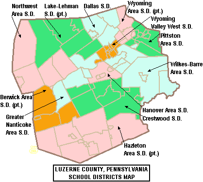
West Hazleton is part of Hazleton Area School District. West Hazleton Elementary/Middle School is located within the borough.
Demographics
2020 census
| Race / Ethnicity (NH = Non-Hispanic) | title=P004: Hispanic or Latino, and Not Hispanic or Latino by Race – 2000: DEC Summary File 1 – West Hazleton borough, Pennsylvania | url=https://data.census.gov/table?g=160XX00US4283136&tid=DECENNIALSF12000.P004 | publisher=United States Census Bureau | access-date=}} | title=P2: Hispanic or Latino, and Not Hispanic or Latino by Race – 2010: DEC Redistricting Data (PL 94-171) – West Hazleton borough, Pennsylvania | url=https://data.census.gov/cedsci/table?q=p2&g=160XX00US4283136&tid=DECENNIALPL2010.P2 | publisher=United States Census Bureau | access-date=}} | % 2000 | % 2010 |
|---|---|---|---|---|---|---|---|---|---|---|
| White alone (NH) | 3,418 | 2,834 | 1,834 | 96.50% | ||||||
| Black or African American alone (NH) | 20 | 62 | 113 | 0.56% | ||||||
| Native American or Alaska Native alone (NH) | 2 | 9 | 0 | 0.06% | ||||||
| Asian alone (NH) | 8 | 15 | 22 | 0.23% | ||||||
| Pacific Islander alone (NH) | 0 | 4 | 1 | 0.00% | ||||||
| Some Other Race alone (NH) | 0 | 8 | 44 | 0.00% | ||||||
| Mixed race or Multiracial (NH) | 15 | 38 | 50 | 0.42% | ||||||
| Hispanic or Latino (any race) | 79 | 1,624 | 3,099 | 2.23% | ||||||
| Total | 3,542 | 4,594 | 5,163 | 100.00% |
2010 census
As of the 2010 census, West Hazleton was 71.9% White, 3.1% Black or African American, 0.4% Native American, 0.3% Asian, 0.1% Native Hawaiian, and 3.4% were two or more races. 35.4% of the population were of Hispanic or Latino ancestry, up from just 2.2% in 2000.
As of the census of 2000, there were 3,542 people, 1,634 households, and 915 families residing in the borough. The population density was 2,281.0 PD/sqmi. There were 1,834 housing units at an average density of 1,181.1 /sqmi. The racial makeup of the borough was 97.71% White, 0.56% African American, 0.06% Native American, 0.23% Asian, 1.02% from other races, and 0.42% from two or more races. Hispanic or Latino of any race were 2.23% of the population.
There were 1,634 households, out of which 21.6% had children under the age of 18 living with them, 38.9% were married couples living together, 12.0% had a female householder with no husband present, and 44.0% were non-families. 39.2% of all households were made up of individuals, and 18.6% had someone living alone who was 65 years of age or older. The average household size was 2.13 and the average family size was 2.86.
In the borough the population was spread out, with 20.3% under the age of 18, 6.7% from 18 to 24, 27.4% from 25 to 44, 22.4% from 45 to 64, and 23.1% who were 65 years of age or older. The median age was 42 years. For every 100 females there were 92.8 males. For every 100 females age 18 and over, there were 88.1 males.
The median income for a household in the borough was $28,765, and the median income for a family was $37,476. Males had a median income of $30,139 versus $18,400 for females. The per capita income for the borough was $16,525. About 7.3% of families and 10.0% of the population were below the poverty line, including 13.8% of those under age 18 and 11.1% of those age 65 or over.
Gallery
Children's Home, West Hazelton, Penna (85795).jpg|Children's Home, West Hazleton The Miners Bank and War Memorial of West Hazelton, Pa (78887).jpg|The Miners Bank and War Memorial, West Hazleton
References
References
- "2019 U.S. Gazetteer Files". United States Census Bureau.
- "City and Town Population Totals: 2020—2021". US Census Bureau.
- "West Hazleton - .: HOME".
- (2011-02-12). "US Gazetteer files: 2010, 2000, and 1990". [[United States Census Bureau]].
- "2020 CENSUS - SCHOOL DISTRICT REFERENCE MAP: Luzerne County, PA". [[U.S. Census Bureau]].
- "[http://www.hasdk12.org/domain/29 Locate Us]." [[Hazleton Area School District]]. Retrieved on July 18, 2016.
- "Census of Population and Housing". Census.gov.
- "P004: Hispanic or Latino, and Not Hispanic or Latino by Race – 2000: DEC Summary File 1 – West Hazleton borough, Pennsylvania". [[United States Census Bureau]].
- "P2: Hispanic or Latino, and Not Hispanic or Latino by Race – 2010: DEC Redistricting Data (PL 94-171) – West Hazleton borough, Pennsylvania". [[United States Census Bureau]].
- "P2: Hispanic or Latino, and Not Hispanic or Latino by Race – 2020: DEC Redistricting Data (PL 94-171) – West Hazleton borough, Pennsylvania". [[United States Census Bureau]].
- "Census 2010: Pennsylvania".
- "U.S. Census website". [[United States Census Bureau]].
This article was imported from Wikipedia and is available under the Creative Commons Attribution-ShareAlike 4.0 License. Content has been adapted to SurfDoc format. Original contributors can be found on the article history page.
Ask Mako anything about West Hazleton, Pennsylvania — get instant answers, deeper analysis, and related topics.
Research with MakoFree with your Surf account
Create a free account to save articles, ask Mako questions, and organize your research.
Sign up freeThis content may have been generated or modified by AI. CloudSurf Software LLC is not responsible for the accuracy, completeness, or reliability of AI-generated content. Always verify important information from primary sources.
Report