From Surf Wiki (app.surf) — the open knowledge base
West Glacier, Montana
Unincorporated community in Montana, United States

Unincorporated community in Montana, United States
| Field | Value |
|---|---|
| official_name | West Glacier, Montana |
| settlement_type | Census-designated place |
| image_skyline | West Glacier Montana Sign looking east on US2.jpg |
| image_caption | Sign for West Glacier on US Route 2 |
| pushpin_map | USA Montana |
| pushpin_label | West Glacier |
| subdivision_type | Country |
| subdivision_name | United States |
| subdivision_type1 | State |
| subdivision_name1 | Montana |
| subdivision_type2 | County |
| subdivision_name2 | Flathead |
| unit_pref | Imperial |
| area_footnotes | |
| area_total_km2 | 10.92 |
| area_land_km2 | 10.73 |
| area_water_km2 | 0.19 |
| area_total_sq_mi | 4.22 |
| area_land_sq_mi | 4.14 |
| area_water_sq_mi | 0.07 |
| population_as_of | 2020 |
| population_total | 221 |
| population_density_km2 | 20.60 |
| population_density_sq_mi | 53.36 |
| timezone | Mountain (MST) |
| utc_offset | -7 |
| timezone_DST | MDT |
| utc_offset_DST | -6 |
| elevation_footnotes | |
| elevation_ft | 3202 |
| coordinates | |
| postal_code_type | ZIP codes |
| postal_code | 59921, 59936 |
| area_code | 406 |
| blank_name | FIPS code |
| blank_info | 30-79075 |
| blank1_name | GNIS feature ID |
| blank1_info | 2583863 |
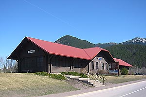
West Glacier is an unincorporated community and census-designated place (CDP) in eastern Flathead County, Montana, United States. As of the 2020 census it had a population of 221. The town is at the west entrance to Glacier National Park and is located on U.S. Route 2 and a main line of the BNSF Railway. The headquarters complex for Glacier National Park is located nearby.
History
Remote and almost inaccessible, the West Glacier area drew only limited attention by white settlers until the main line of the Great Northern Railway (GNR) reached the northern Rocky Mountains in 1890. The transcontinental GNR was completed on January 6, 1893, at Scenic, Washington.
The railroad established a station named "Belton" at the current West Glacier site, and a small community slowly began to develop in the area. A post office was established at Belton in 1900. The number of homesteaders and other settlers remained small, however, due to the region's rugged, heavily forested terrain.
The community, heavily dependent on tourism, has a small permanent population that expands significantly during the summer tourist season; most area businesses are likewise seasonal—including the 18-hole golf course—and are primarily geared towards travelers. The elevation is 3169 ft.
The Swiss-style Belton Chalets in West Glacier, originally built in 1910, was the first Great Northern Railway hotel at Glacier National Park and would welcome guests arriving by train to the park, before they would travel into the park's back-country chalets and tent camps. During the Great Depression, the Belton Chalet housed the crews working on the Going-to-the-Sun Road. Over the years, the chalet housed many businesses, while today it is one of Montana's grandest historic hotels. The chalet survives today under new ownership and is a registered National Historic Landmark.
In 1949 the town changed its name from Belton to West Glacier to promote the tourism potential.
Tourism
Railroad tourism
By the early twentieth century a small number of tourists had begun to visit the spectacular mountain landscapes east and north of Belton, and in 1910 that area was set aside as Glacier National Park. As the railway station nearest the area, Belton became a primary gateway to Glacier, and the park headquarters was established there. Currently Amtrak's Empire Builder makes stops daily at the West Glacier station.
Automobile tourism

The growth of tourist traffic through Belton increased substantially in the 1920s and 1930s, largely due to the improvement of automobile routes through the area. U.S. Highway 2 was completed eastward from Belton over Marias Pass in 1930, and the Going-to-the-Sun Road was completed across Glacier Park in 1932. In 1938, a number of tourist-oriented businesses were constructed at the western end of the Going-to-the-Sun Road in Belton, forming the core of a new commercial district for the town. These businesses, owned by the Lundgren family since 1946, remain today.
The town of Belton was renamed "West Glacier" in 1949, to better reflect its geographic location and make it more identifiable to tourists, although the railroad station and chalet complex retained the Belton name.
Demographics
Climate
According to the Köppen Climate Classification, it is a warm summer continental climate (Dfb), bordering a continental warm summer Mediterranean climate (Dsb).
|Jan avg record high F = 42.3 |Feb avg record high F = 44.9 |Mar avg record high F = 55.5 |Apr avg record high F = 69.4 |May avg record high F = 80.3 |Jun avg record high F = 85.7 |Jul avg record high F = 90.8 |Aug avg record high F = 90.8 |Sep avg record high F = 82.7 |Oct avg record high F = 69.3 |Nov avg record high F = 52.1 |Dec avg record high F = 41.7 |year avg record high F = 92.6
|Jan avg record low F = -7.3 |Feb avg record low F = -3.1 |Mar avg record low F = 5.6 |Apr avg record low F = 19.9 |May avg record low F = 27.1 |Jun avg record low F = 34.6 |Jul avg record low F = 39.4 |Aug avg record low F = 36.9 |Sep avg record low F = 29.3 |Oct avg record low F = 17.4 |Nov avg record low F = 7.0 |Dec avg record low F = -1.6 |year avg record low F = -16.1
|Jan record high F = 55 |Feb record high F = 58 |Mar record high F = 66 |Apr record high F = 83 |May record high F = 90 |Jun record high F = 98 |Jul record high F = 99 |Aug record high F = 100 |Sep record high F = 95 |Oct record high F = 79 |Nov record high F = 65 |Dec record high F = 60 |year record high F = |Jan record low F = -39 |Feb record low F = -32 |Mar record low F = -30 |Apr record low F = 3 |May record low F = 13 |Jun record low F = 24 |Jul record low F = 31 |Aug record low F = 26 |Sep record low F = 18 |Oct record low F = -3 |Nov record low F = -17 |Dec record low F = -36 |year record low F = | access-date = April 25, 2023 | archive-date = August 3, 2021 | archive-url = https://web.archive.org/web/20210803052627/https://w2.weather.gov/climate/xmacis.php?wfo=mso | url-status = dead | access-date = April 25, 2023
References
References
- "ArcGIS REST Services Directory". United States Census Bureau.
- {{GNIS. 2583863
- "Explore Census Data".
- "Glacier National Park".
- "West Glacier". Montana Historical Society.
- "Belton Chalet - West Glacier".
- "Glacier National Park -- History and Culture".
- "Going to the Sun Road - status". National Park Service.
- Carr, p. 186.
- "Census of Population and Housing". Census.gov.
This article was imported from Wikipedia and is available under the Creative Commons Attribution-ShareAlike 4.0 License. Content has been adapted to SurfDoc format. Original contributors can be found on the article history page.
Ask Mako anything about West Glacier, Montana — get instant answers, deeper analysis, and related topics.
Research with MakoFree with your Surf account
Create a free account to save articles, ask Mako questions, and organize your research.
Sign up freeThis content may have been generated or modified by AI. CloudSurf Software LLC is not responsible for the accuracy, completeness, or reliability of AI-generated content. Always verify important information from primary sources.
Report