From Surf Wiki (app.surf) — the open knowledge base
Washtenaw County, Michigan
County in Michigan, United States

County in Michigan, United States
| Field | Value |
|---|---|
| county | Washtenaw County |
| state | Michigan |
| seal | Seal of Washtenaw County, Michigan.svg |
| seal size | 160 |
| founded year | (created) |
| 1826 (organized) | |
| seat wl | Ann Arbor |
| largest city wl | Ann Arbor |
| area_total_sq_mi | 722 |
| area_land_sq_mi | 706 |
| area_water_sq_mi | 16 |
| area percentage | 2.3% |
| census yr | 2020 |
| pop | 372258 |
| pop_est_as_of | 2024 |
| population_est | 373875 |
| density_sq_mi | 527 |
| district | 6th |
| time zone | Eastern |
| web | washtenaw.org |
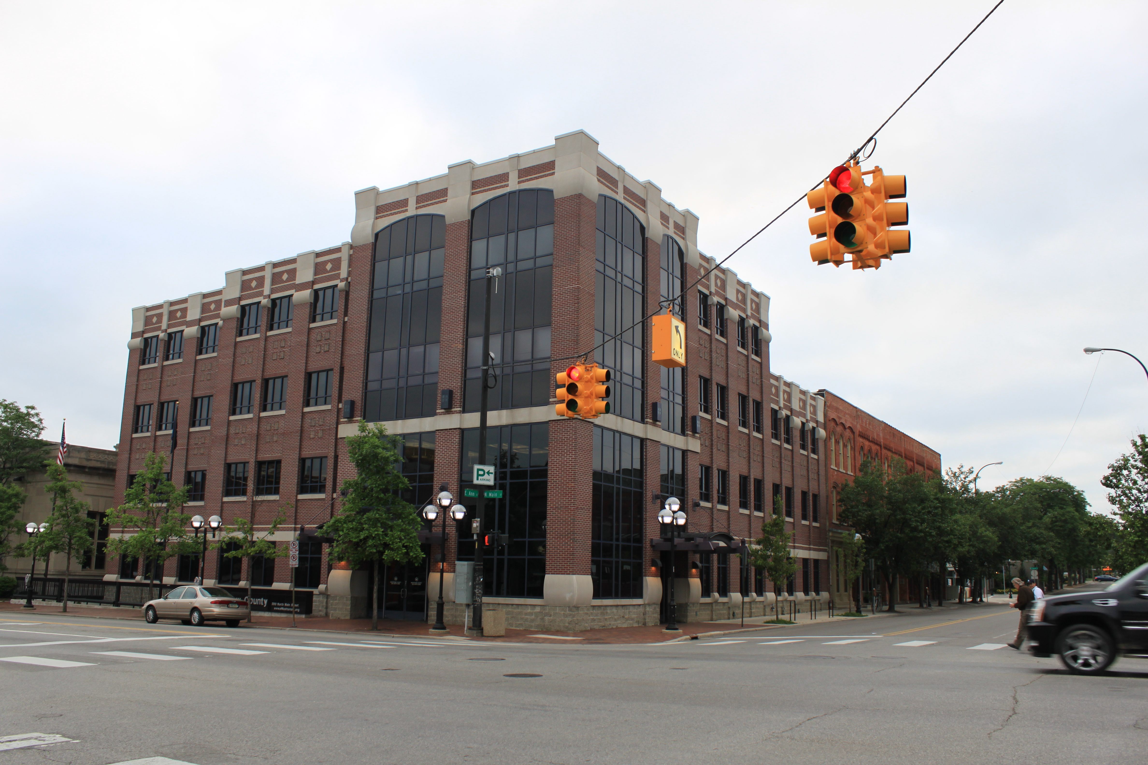
| ex image | Washtenaw County Courthouse (Ann Arbor).jpg |
| ex image cap | Washtenaw County Courthouse |
| named for | O-wash-ta-nong ("far away water"), Ojibwe name for the Grand River |
1826 (organized)
Washtenaw County ( ) is a county located in the U.S. state of Michigan. At the 2020 census, the population was 372,258. The county seat and largest city is Ann Arbor. The county was authorized by legislation in 1822 and organized as a county in 1826. Washtenaw County comprises the Ann Arbor Metropolitan Statistical Area. The county is home to the University of Michigan, Eastern Michigan University, Washtenaw Community College, and Concordia University Ann Arbor.
History
Native American territories
The first peoples occupying the central portion of what is now Michigan included: "the Pottawattamies, the Chippewas, the Ottawas, the Wyandottes and the Hurons". Native Americans whose territories included land within the Washtenaw County boundaries are shown to have included: Myaamia (Miami), Bodéwadmiké (Potawatomi), Anishinabewaki ᐊᓂᔑᓈᐯᐗᑭ, Peoria, Meškwahki·aša·hina (Meskwaki), and the Mississauga nation.
Etymology of Washtenaw
In the Ojibwe language, "Wash-ten-ong" or "Owashtanong" literally translates as "far away waters", and was then used by the Ojibwe as the name for the Grand River due to its great length. At the time of the official naming of the county in 1822, the headwaters of the Grand River fell within the original boundaries of Washtenaw County, which encompassed a much larger area than the present county.
Early colonization
The earliest histories mention French trappers and traders conducting trade in the area at the Potawatomi Trail and Pontiac Trail crossings of the Huron River, and later English then American settlers. The first successful settlement was established at the present site of Ypsilanti about 1809 by French traders.
In 1822, the Legislative Council of Michigan Territory government defined the name and boundaries of the county, but attached it to Wayne County for revenue, taxation and judicial affairs. Four years after the first platting out of the county, Washtenaw was established as a separate self-administered county by an act of the Michigan Territorial Legislature, in 1826. It was attached for administrative purposes to Wayne County until (before 1829) when county government was seated. Ingham and other counties were formed from portions of territorial Washtenaw County.
Swamps were drained to lower the water table. The swamp northwest of the I-94 and US-23 intersection, and areas within Waterloo Recreation Area still appear as they did to early settlers. As productive farms became established, the local deer herds grew. In the 1820s and 1830s, the events surrounding the independence of Greece from Turkey inspired construction of Greek Revival buildings, and the names of townships, towns, and children.
The "frostbitten convention" was held at Ann Arbor, the county seat, in 1835. Statehood was delayed because Michigan claimed the Toledo Strip, which was also claimed by Ohio. Following resolution of the Toledo War (1835–1836), in which Michigan Territory ceded its claim to Toledo in exchange for most of the Upper Peninsula (from the Porcupine Mountains eastward), Ohio withdrew its objection and Michigan became a state on January 26, 1837.
The convention also decided to move the capital from Detroit to a point further away from the Canadian border. After considering many existing communities, the delegates decided to build an entirely new capital city, which became Lansing. The University of Michigan, founded at Detroit in 1817, was moved to Ann Arbor in 1839 as a consolation for the city not being named the new state capital, as it had sought. The university subsequently became and remains Washtenaw County's largest employer.
In 1849, the Michigan State Normal School (now Eastern Michigan University) was established in Washtenaw's oldest settlement, Ypsilanti. It was elevated to collegiate status c. 1891 as Michigan State Normal College. The name was changed in 1956 to Eastern Michigan College, which was elevated to university status in 1959.
Geography
According to the U.S. Census Bureau, the county has a total area of 722 sqmi, of which 706 sqmi is land and 16 sqmi (2.3%) is water.
Adjacent counties
- Livingston County (north)
- Oakland County (northeast)
- Wayne County (east)
- Monroe County (southeast)
- Lenawee County (southwest)
- Jackson County (west)
- Ingham County (northwest)
Major highways
Demographics
|align-fn=center 1790–1960 1900–1990 1990–2000 2010–2019
2020 census
As of the 2020 census, the county had a population of 372,258. The median age was 34.5 years. 18.4% of residents were under the age of 18 and 14.8% of residents were 65 years of age or older. For every 100 females there were 96.5 males, and for every 100 females age 18 and over there were 94.8 males age 18 and over.
The racial makeup of the county was 69.2% White, 11.5% Black or African American, 0.3% American Indian and Alaska Native, 9.0% Asian, 0.1% Native Hawaiian and Pacific Islander, 2.0% from some other race, and 7.9% from two or more races. Hispanic or Latino residents of any race comprised 5.6% of the population.
82.8% of residents lived in urban areas, while 17.2% lived in rural areas.
There were 147,847 households in the county, of which 25.0% had children under the age of 18 living in them. Of all households, 43.4% were married-couple households, 21.6% were households with a male householder and no spouse or partner present, and 28.2% were households with a female householder and no spouse or partner present. About 31.4% of all households were made up of individuals and 9.9% had someone living alone who was 65 years of age or older.
There were 156,882 housing units, of which 5.8% were vacant. Among occupied housing units, 60.3% were owner-occupied and 39.7% were renter-occupied. The homeowner vacancy rate was 1.1% and the rental vacancy rate was 5.7%.
Language and income data
83.4% spoke only English at home; 3.7% spoke Spanish and 12.9% spoke another language.
The median income for a household in the county was $83,754 and the median income for a family was $116,562. 15.3% of people were under the poverty line.
Government
Elected officials
- Prosecuting Attorney: Eli Savit (Democrat)
- Sheriff: Alyshia M. Dyer (Democrat)
- County Clerk/Register of Deeds: Lawrence Kestenbaum (Democrat)
- County Treasurer: Latitia Lamelle Sharp (Democrat)
- Water Resources Commissioner: Gretchen Driskell (Democrat)
The Board of Commissioners has nine members, elected from single member districts, on a partisan ballot, in November of even-numbered years. The term is two years. Information as of October 2024.
| District | Commissioner | Party | Positions |
|---|---|---|---|
| 1 | Jason Maciejewski | Democrat | |
| 2 | Crystal Lyte | Democrat | |
| 3 | Shannon Beeman | Democrat | |
| 4 | Caroline Sanders | Democrat | Vice Chair of the Board |
| 5 | Justin Hodge | Democrat | Board Chair |
| 6 | Annie Sommerville | Democrat | Working Session Committee Chair |
| 7 | Andy LaBarre | Democrat | Vice Chair of the Working Session |
| 8 | Yousef Rabhi | Democrat | |
| 9 | Katie Scott | Democrat |
Government services
Parks and recreation
Washtenaw County operates 10 parks and one recreation center (gymnasium). One park has a water sprinkler area, one has a substantial water park component, and there is one golf course. The recreation center has a swimming pool, indoor track, basketball courts, complete set of resistance machines, a weight room, and several multipurpose rooms.
Washtenaw County is in the process of acquiring land for natural preservation. The program started in 2001, was renewed in 2010. The millage was renewed a second time in 2020 with a record high of 72% of votes supporting the renewal. Eight parcels of land had been purchased by July 2007. These parcels are of special ecological, recreational, and educational benefits. They are preserved in a natural unimproved state and are open to the public during daylight hours.
Wireless communication
In partnership with private enterprise, the county maintains a wireless network which is currently available to approximately 50% of county residents. This is the Wireless Washtenaw Project; its stated aim of this project is to provide wireless access to all county residents.
Miscellaneous
The county government operates the jail, maintains rural roads (through a largely independent road commission), operates the major local courts, records deeds and mortgages, maintains vital records, administers public health regulations, and participates with the state in providing welfare and social services. The county board of commissioners controls the budget and has limited authority to make laws or ordinances. In Michigan, most local government functions – police and fire, building and zoning, tax assessment, street maintenance, etc. – are the responsibility of individual cities and townships.
Politics
Since 1988, when Michael Dukakis won it, the county has been a Democratic stronghold in local and national elections due to the presence of Ann Arbor and the University of Michigan. In the 2020 United States presidential election it gave 72.4% of the vote to Democratic nominee Joe Biden, the highest margin for a Democrat in the county, the third-highest for any candidate in the county's history, and the highest in the state at the time as well. Between 1960 and 1988 it was generally a swing county: 1992 marked the first time that the county supported the same party as in the previous election since 1960.
Despite its modern-day Democratic strength, it was reliably Republican at the presidential level from 1896 to 1960, only voting Democratic once in that span in 1912 when the Republican vote was split. It was one of the few counties where Franklin D. Roosevelt was shut out in all four of his successful campaigns. George McGovern's win over Richard Nixon in the county in 1972 despite the latter winning nationally by a landslide was a sign of the county's shift towards supporting the Democratic Party, though Michigander and former Wolverine Gerald R. Ford won it in 1976 and Ronald Reagan won it in 1984 amid his national landslide, being the most recent Republican to win the county.
Economy

The largest employers in Washtenaw County, as of July 2020, are:
| # | Employer | # of full-time employees |
|---|---|---|
| 1 | University of Michigan | 35,446 |
| 2 | Trinity Health | 7,435 |
| 3 | United States Federal government | 3,060 |
| 4 | Ann Arbor Public Schools | 2,607 |
| 5 | Toyota Technical Center | 2,295 |
| 6 | Faurecia North America | 2,178 |
| 7 | Eastern Michigan University | 1,559 |
| 8 | IHA Health Services | 1,442 |
| 9 | State of Michigan | 1,409 |
| 10 | Washtenaw County | 1,264 |
| 11 | Thomson Reuters | 1,155 |
| 12 | Domino's Pizza | 812 |
| 13 | City of Ann Arbor | 712 |
| 14 | Ford Motor Company | 700 |
| 15 | NSF International | 693 |
| 16 | US Postal Service | 650 |
| 17 | Washtenaw Community College | 597 |
| 18 | DTE Energy | 568 |
| 19 | Ypsilanti Community Schools | 550 |
Communities

Cities
- Ann Arbor (county seat)
- Chelsea
- Dexter
- Manchester
- Milan (northern part; southern part is in Monroe County)
- Saline
- Ypsilanti
Village
- Barton Hills
Charter townships
- Ann Arbor Charter Township
- Augusta Charter Township
- Pittsfield Charter Township
- Superior Charter Township
- York Charter Township
- Ypsilanti Charter Township
Civil townships
- Bridgewater Township
- Dexter Township
- Freedom Township
- Lima Township
- Lodi Township
- Lyndon Township
- Manchester Township
- Northfield Township
- Salem Township
- Saline Township
- Scio Township
- Sharon Township
- Sylvan Township
- Webster Township
Census-designated place
- Whitmore Lake (partly in Washtenaw County and partly in Livingston County)
Other unincorporated communities
- Bridgewater
- Dixboro
- Delhi Mills
- Geddes
- Mooreville
- Paint Creek
- Salem
- Stony Creek
- Whittaker
- Willis
Ghost town
- Rawsonville (partial)
Education
School districts include:{{cite map|author=Geography Division|url=https://www2.census.gov/geo/maps/DC2020/PL20/st26_mi/schooldistrict_maps/c26161_washtenaw/DC20SD_C26161.pdf |archive-url=https://web.archive.org/web/20220622050758/https://www2.census.gov/geo/maps/DC2020/PL20/st26_mi/schooldistrict_maps/c26161_washtenaw/DC20SD_C26161.pdf |archive-date=June 22, 2022 |url-status=live|title=2020 CENSUS - SCHOOL DISTRICT REFERENCE MAP: Washtenaw County, MI|publisher=U.S. Census Bureau|date=January 15, 2021
- Ann Arbor Public Schools
- Columbia School District
- Chelsea School District
- Clinton Community Schools
- Dexter Community School District
- Grass Lake Community Schools
- Lincoln Consolidated School District
- Manchester Community Schools
- Milan Area Schools
- Northville Public Schools
- Pinckney Community Schools
- Plymouth-Canton Community Schools
- Saline Area Schools
- South Lyon Community Schools
- Stockbridge Community Schools
- Van Buren Public Schools
- Whitmore Lake Public Schools
- Ypsilanti Community Schools
Former school districts:
- Ypsilanti Public Schools
- Willow Run Community Schools
References
Sources
References
- "Bibliography on Washtenaw County". [[Clarke Historical Library]], [[Central Michigan University]].
- "About —". ewashtenaw.org.
- "US Census QuickFacts". US Census Bureau.
- "Find a County". National Association of Counties.
- (2013). "Publications of the Historical Society of Grand Rapids, Vol. 1, Parts 1–7".
- "Myaamia".
- "Bodéwadmiké (Potawatomi) territory".
- "Anishinabewaki ᐊᓂᔑᓈᐯᐗᑭ".
- "Peoria".
- "Meškwahki·aša·hina (Fox)".
- "Mississauga".
- (2013). "Washtenaw County Historical Society: Etymology of the Name".
- (August 22, 2012). "2010 Census Gazetteer Files". US Census Bureau.
- "Population and Housing Unit Estimates Tables". United States Census Bureau.
- "US Decennial Census". US Census Bureau.
- "Historical Census Browser". University of Virginia Library.
- "Population of Counties by Decennial Census: 1900 to 1990". US Census Bureau.
- "Census 2000 PHC-T-4. Ranking Tables for Counties: 1990 and 2000". US Census Bureau.
- (2021). "2020 Decennial Census Demographic Profile (DP1)".
- (2021). "2020 Decennial Census Redistricting Data (Public Law 94-171)".
- (2023). "2020 Decennial Census Demographic and Housing Characteristics (DHC)".
- "From the Director – Natural Areas Preservation Program Millage Renewal".
- Larson, Lucas Smolcic. (December 2, 2022). "$1.44M conservation purchase sets up one of largest nature preserves in Ann Arbor area".
- Leip, David. "Dave Leip's Atlas of U.S. Presidential Elections".
- (November 3, 2020). "Michigan Election Results". The New York Times.
- "Datajoe - Product Download".
- Geography Division. (January 5, 2011). "SCHOOL DISTRICT REFERENCE MAP (2010 CENSUS): Washtenaw County, MI". [[U.S. Census Bureau]].
This article was imported from Wikipedia and is available under the Creative Commons Attribution-ShareAlike 4.0 License. Content has been adapted to SurfDoc format. Original contributors can be found on the article history page.
Ask Mako anything about Washtenaw County, Michigan — get instant answers, deeper analysis, and related topics.
Research with MakoFree with your Surf account
Create a free account to save articles, ask Mako questions, and organize your research.
Sign up freeThis content may have been generated or modified by AI. CloudSurf Software LLC is not responsible for the accuracy, completeness, or reliability of AI-generated content. Always verify important information from primary sources.
Report