From Surf Wiki (app.surf) — the open knowledge base
Washington State Route 24
State highway in south-central Washington, US

State highway in south-central Washington, US
| Field | Value | |||
|---|---|---|---|---|
| state | WA | |||
| type | SR | |||
| route | 24 | |||
| section | 100 | |||
| map | ||||
| map_custom | yes | |||
| map_notes | Map of the Mid-Columbia region with SR 24 highlighted in red | |||
| length_mi | 79.23 | |||
| length_round | 2 | |||
| length_ref | ||||
| established | 1964 | |||
| direction_a | West | |||
| terminus_a | in Yakima | |||
| junction | {{plainlist | |||
| * {{jct | state | WA | SR | 240}} near Vernita Bridge |
| * {{jct | state | WA | SR | 243}} near Vernita Bridge |
| direction_b | East | |||
| terminus_b | in Othello | |||
| counties | Yakima, Benton, Grant, Adams | |||
| previous_type | SR | |||
| previous_route | 23 | |||
| next_type | SR | |||
| next_route | 25 |
- near Vernita Bridge
- near Vernita Bridge
State Route 24 (SR 24) is a state highway in the south-central region of Washington, in the United States. It travels 79 mi from Yakima to Othello, across a portion of the Columbia Plateau. The highway crosses the Columbia River on the Vernita Bridge, located near the Hanford Site. SR 24 terminates to the west at an interchange with Interstate 82 (I-82) in Yakima and to the east at SR 26 in Othello.
The highway was added to the state highway system in 1937 as Secondary State Highway 11A (SSH 11A), composed of several county-built gravel roads from Yakima to Connell, with a ferry crossing at Hanford. The Hanford section of SSH 11A was closed in 1943 due to wartime activities at the Hanford Nuclear Reservation, forcing the state government to relocate the highway to the north side of the Columbia River. The new highway opened in 1961 and was supplanted by the new Vernita toll bridge in 1965. During the 1964 state highway renumbering, SR 24 replaced most of SSH 11A and was rerouted to a terminus in Othello.
Route description
SR 24 begins in eastern Yakima as an extension of Nob Hill Boulevard at a diamond interchange with I-82 and the concurrent US 12 and US 97. The interchange is located southeast of the Central Washington State Fairgrounds and the SunDome arena. SR 24 travels southeasterly from the interchange as a four-lane divided highway and crosses the Yakima River into unincorporated Yakima County near Yakima Sportsman State Park. The highway narrows to two lanes and continues southeast along the Central Washington Railroad, a branch of the BNSF Railway, changing course to bypass the city of Moxee on its south side. SR 24 continues beyond the railroad's terminus and runs deeper into the Moxee Valley, an irrigated area situated between the Yakima Ridge and Yakima Training Center to the north and the Rattlesnake Hills to the south.
At the east end of the valley, SR 24 turns northeast and crosses through a narrow pass in the hills before reaching the Black Rock Valley, which it continues across. Midway through the valley at the Silver Dollar Cafe, the highway intersects SR 241, an auxiliary route that travels south towards Sunnyside. SR 24 continues northeast from the junction and enters Benton County, where it climbs a section of the Yakima Ridge and exits the valley. The highway crosses part of the Fitzner–Eberhardt Arid Lands Ecology Reserve, a restricted wildlife preserve that forms part of the Hanford Reach National Monument. SR 24 meets SR 240, a major highway connecting to the Tri-Cities, at the northeast corner of the reserve. SR 24 turns north at the junction and travels along the northwest edge of the Hanford Site, flanked by fences on both sides of the road. The highway descends from the plateau by turning west and returning to its northerly course, eventually reaching a rest area on the south shore of the Columbia River.
SR 24 crosses the Columbia River on the Vernita Bridge, a 1982 ft steel truss bridge downriver from the Priest Rapids Dam.{{cite web |author=Bridge and Structures Office |date=November 2017 |title=Bridge List (M 23-09.08)
SR 24 is maintained by the Washington State Department of Transportation (WSDOT), which conducts an annual survey on the state's highways to measure traffic volume in terms of annual average daily traffic. The busiest section of the highway, at its interchange with I-82, carried a daily average of 23,000 vehicles in 2016; the least busiest section of the highway, northeast of the Vernita Bridge, carried only 1,100 vehicles. A short section between I-82 and Faucher Road in Moxee is designated as a MAP-21 arterial under the National Highway System, a network of roads identified as important to the national economy, defense, and mobility.
History
SR 24 was added to Washington's state highway system in 1937 as Secondary State Highway 11A (SSH 11A), which traveled from Primary State Highway 3 (PSH 3) and US 410 in Yakima to PSH 11 and US 395 in Connell. The highway was preceded by several unpaved roads built by county governments along the corridor by the 1910s, including a road across the Moxee and Black Rock valleys, a ferry across the Columbia River at White Bluffs, and a road continuing to Connell, bypassing Othello.
The state government did not improve the gravel county roads that encompassed SSH 11A, but did relocate its toll-free ferry from White Bluffs to Hanford in May 1938. The Hanford ferry was initially planned to use a cable-operated system, but costs forced it to be downgraded to a tug-and-barge ferry. During World War II, the U.S. military selected the Hanford area as the site of a major weapons development facility and a section of SSH 11A was acquired via a request of the Secretary of War filed on July 21, 1943. The 28 mi section, located between Cold Creek and Hanford, was closed permanently to non-military traffic on November 15, 1943, and divided SSH 11A into two disconnected highways. The rest of the highway had been paved by the state government in the early 1940s, with the exception of a section west of Connell that remained gravel.
SSH 11A was relocated in 1953 to a crossing of the Columbia River north of Cold Creek at Vernita and would continue along a new highway along the Columbia River to the east end of the former Hanford ferry. The state government had initially expected the highway to re-open after the war, but continued use of Hanford for weapons and energy development prompted them to file a lawsuit against the federal government to seek reimbursement to fund construction of the new highway around the site. The U.S. District Court's decision to award only $1 in nominal damages in 1952 was upheld by a decision of the Ninth Circuit Court of Appeals two years later, citing the state's delay in identifying a suitable alternate route. In response, Representative Donald H. Magnuson introduced a Congressional bill to reimburse $581,721 to the state (equivalent to $ in dollars), but it was vetoed by President Dwight D. Eisenhower in September 1957.
.jpg)
From January 1954 to December 1955, Army Corps of Engineers constructed a dirt road on the north side of the Columbia River between Vernita and White Bluffs, passing through a less-restricted portion of the Hanford Site. The road was built as part of an agreement between the state and federal governments that was negotiated during the lawsuit, as an alternative to re-opening SSH 11A across the Hanford restricted zone. A private toll ferry connecting SSH 11A at Vernita to SSH 7C on the north side of the river began operating in November 1957 and was taken over by the state in May 1961. The state government completed construction of the paved 8.3 mi highway along the Wahluke Slope on May 19, 1961, extending SSH 11A to a junction with SSH 11G south of Othello. As part of the agreement with the federal Atomic Energy Commission, the highway was ringed by fences and signs prohibiting parking and loitering, as well as controlled traffic signals that would allow for a large-scale evacuation of the Hanford area. The west end of SSH 11A was truncated to the newly-opened Yakima bypass (part of I-82) in November 1963.
The Vernita Bridge began construction in October 1964 and was opened to traffic on October 1, 1965, replacing the state-run ferry. The bridge was funded using $3 million in bonds (equivalent to $ in dollars) that were paid off using a toll of 75 cents to $2.50 collected until 1977. During the 1964 state highway renumbering, SSH 11A was divided between three new state highways under the sign route system: State Route 24 (SR 24) from Yakima to the junction with SSH 11G (now SR 17), SR 170 from Ringold on the Columbia River to Mesa, and SR 260 between Mesa and Connell. The Ringold section of SR 170 was later transferred to Franklin County in 1967, per a clause in a 1963 highway bill that was triggered by the completion of SR 240. SR 24 was formally codified in 1970, with its eastern terminus changed to a junction with SR 26 south of downtown Othello. The Othello link was built by the end of the decade, effectively completing all of SR 24.
Congestion on a 2 mi section of SR 24 between I-82 and the east side of the Yakima River had worsened by the late 1990s and prompted the state government to consider a $35 million replacement and expansion project. The project was combined with a floodplain restoration plan proposed by the county government in response to a major flood in 1996 and originally considered building a second bridge upriver and realigning the highway. A revised plan placing the higher replacement bridge next to the existing crossing, saving costs and environmental mitigation for 7 acre of wetlands, was adopted in 2002 and funded by the legislature's 2003 Nickel Program gas tax. Construction on the new bridge and the widened four-lane highway began in May 2005 and was dedicated on June 28, 2007, costing a total of $54.5 million. In 2008, the state government also built a series of passing lanes along SR 24 between Silver Dollar and Cold Creek in response to increased truck traffic.
Major intersections
References
References
- {{WSDOT State Highway Log. (2017)
- (1970). "47.17.100: State route No. 24". [[Washington State Legislature]].
- (January 2016). "2015 Washington State Rail System by Owner". Washington State Department of Transportation.
- (January 2014). "BNSF Railway Company Class I Railroad Annual Report". [[BNSF Railway]].
- "State Route 24".
- (April 23, 2018). "Corridor Sketch Summary – SR 24: I-82 Jct (Yakima) to SR 243 Jct". Washington State Department of Transportation.
- Hoang, Mai. (July 30, 2010). "Moxee cafe back in business". [[Tri-City Herald]].
- "General Map of the Hanford Reach National Monument". [[United States Fish and Wildlife Service]].
- Washington State Department of Transportation. (2014). "Washington State Highways, 2014–2015". Washington State Department of Transportation.
- "Safety rest area locations". Washington State Department of Transportation.
- Cary, Annette. (July 3, 2017). "Columbia River closed to boaters near Vernita Bridge for firefighting". Tri-City Herald.
- (April 5, 2018). "Corridor Sketch Summary – SR 24: SR 243 Jct to SR 26 Jct (Othello)". Washington State Department of Transportation.
- (August 21, 2017). "SR 24 – Junction: SR 26". Washington State Department of Transportation.
- (2017). "2016 Annual Traffic Report". Washington State Department of Transportation.
- "2016 State Highway National Highway System Routes in Washington". Washington State Department of Transportation.
- (January 31, 2017). "What is the National Highway System?". [[Federal Highway Administration]].
- (March 18, 1937). "Session Laws of the State of Washington, 1937". Washington State Legislature.
- (1924). "Rand McNally's Commercial Atlas of America". Rand McNally.
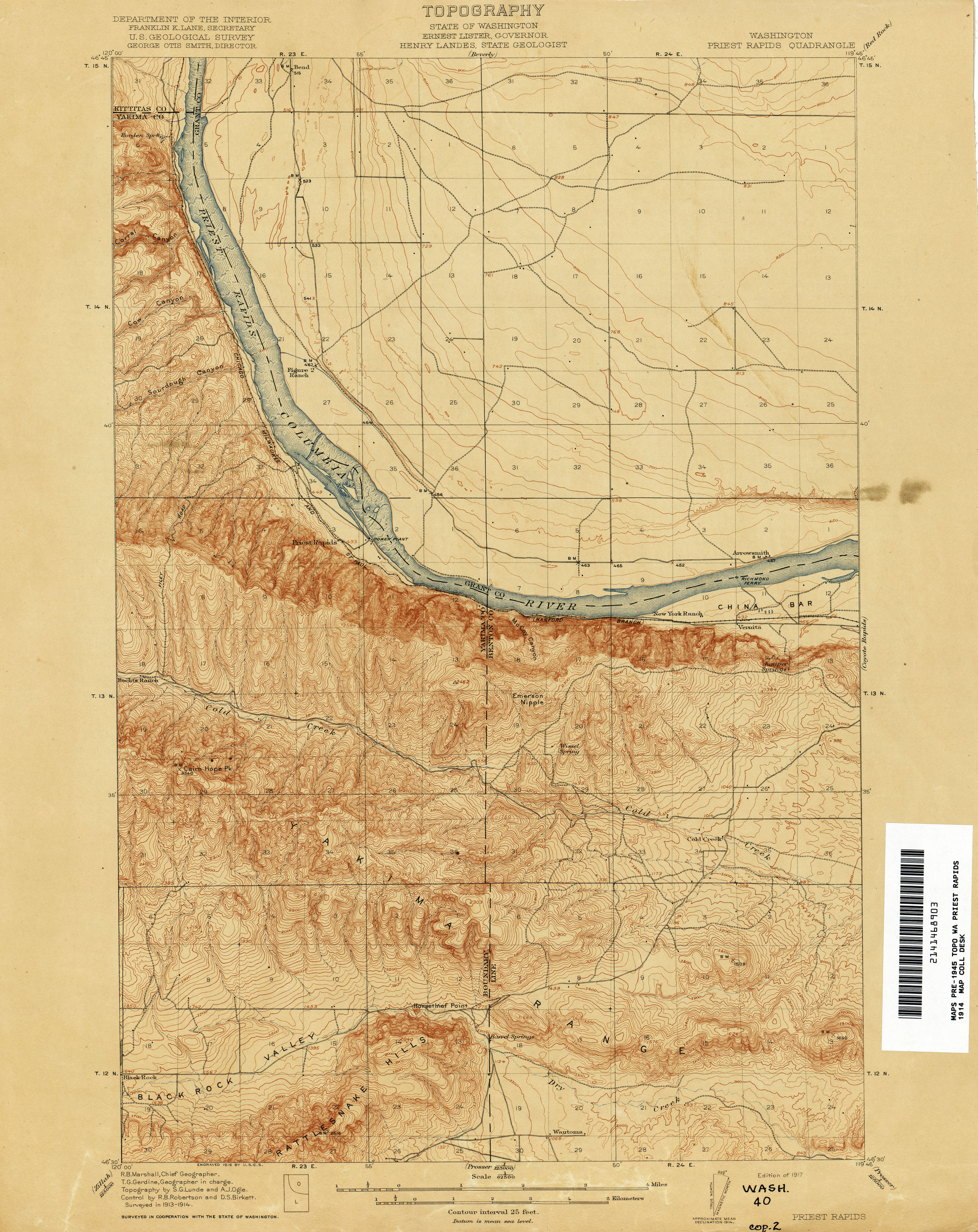
- (1917). "Priest Rapids Quadrangle, Washington". United States Geological Survey.
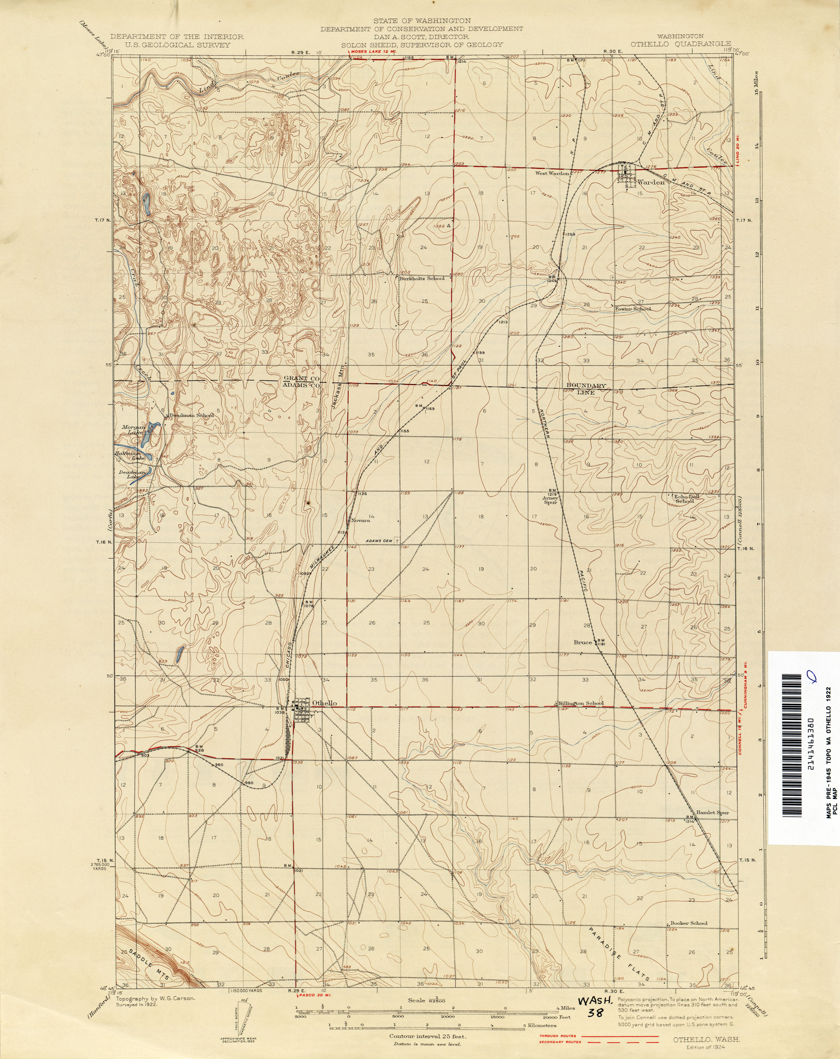
- (1924). "Othello Quadrangle, Washington". United States Geological Survey.
- Rand McNally. (1939). "Highways of the State of Washington". Washington State Department of Highways.
- {{cite court. 9th Circuit]]:. (June 1, 1954). link
- (August 1961). "Highway 11-A opens to Othello". Washington State Department of Highways.
- Smith, Hal G.. (August 1958). "Columbia River Ferry at Hanford Had Interesting History". Washington State Department of Highways.
- (November 11, 1943). "Moxee-to-Hanford Road to Be Closed". [[The Seattle Times]].
- Rand McNally. (1944). "Highways of the State of Washington". Washington State Department of Highways.
- (March 3, 1953). "Session Laws of the State of Washington, 1953". Washington State Legislature.
- (June 1961). "New Highway For Central Washington". Washington State Department of Highways.
- (September 23, 1955). "Alternate Highway Route In Hanford Area Feasible". [[Walla Walla Union-Bulletin]].
- (March 6, 1956). "House Passes Bill For Payment To State". [[Port Angeles Evening News]].
- (September 3, 1957). "President Vetoes Payment For Road". Port Angeles Evening News.
- (November 19, 1957). "New Ferry on Columbia Begins Soon". The Seattle Times.
- (April 12, 1961). "Free Ferry Service Set Near Vernita". Walla Walla Union-Bulletin.
- Tegner, Bob. (March 30, 1961). "New Hanford Route Will Open in June". The Seattle Times.
- (November 1963). "Yakima Freeway Official Opening: November 12, 1963". [[Washington State Highway Commission]].
- (October 8, 1964). "Vernita Bridge Project Started". [[The Spokesman-Review]].
- Morgan, Brian. (October 2, 1965). "New Span's Regional Use Underlined at Vernita Rides". The Spokesman-Review.
- (October 1, 1965). "Columbia River Bridge Opened". The Seattle Times.
- (September 26, 1965). "Transport Boost Is Expected on New Bridge at Vernita". The Spokesman-Review.
- Waugh, Kathleen. (April 2004). "Guide to the Records of the Washington Toll Bridge Authority, 1937–1977". [[Washington Secretary of State]].
- Prahl, C. G.. (December 1, 1965). "Identification of State Highways". Washington State Highway Commission.
- Hauptli, Jack. (February 23, 1964). "Highway Department Plays The Numbers Game!". The Seattle Times.
- (1953). "Walla Walla, Washington; Oregon". United States Geological Survey.
- (March 26, 1963). "Session Laws of the State of Washington, 1963". Washington State Legislature.
- (May 11, 1967). "Session Laws of the State of Washington, 1967 extraordinary session". Washington State Legislature.
- (February 24, 1970). "Session Laws of the State of Washington, 1970 1st extraordinary session". Washington State Legislature.
- (1979). "Priest Rapids, Washington". United States Geological Survey.
- (October 27, 1971). "Route 24: Two-Stage Work Due". [[Spokane Daily Chronicle]].
- Lester, David. (November 4, 2001). "State suggests SR-24 bridge at estimated $35 million". Yakima Herald-Republic.
- Lester, David. (August 25, 2002). "Considering a Change—Loosening the River". Yakima Herald-Republic.
- Lester, David. (December 17, 2002). "State reworks plans for new Yakima River Bridge". Yakima Herald-Republic.
- Ammons, David. (May 20, 2003). "5 cents more at gas pump". Yakima Herald-Republic.
- (June 28, 2007). "SR 24 – I-82 to Keys Road – Additional Lanes". Washington State Department of Transportation.
- (June 28, 2007). "SR 24 bridge project set for today's dedication". Yakima Herald-Republic.
- Courtney, Ross A.. (September 18, 2008). "SR 24 drivers find relief". Yakima Herald-Republic.
- (September 2008). "SR 24 – SR 241 to Cold Creek Road: Add Passing Lanes (Folio)". Washington State Department of Transportation.
This article was imported from Wikipedia and is available under the Creative Commons Attribution-ShareAlike 4.0 License. Content has been adapted to SurfDoc format. Original contributors can be found on the article history page.
Ask Mako anything about Washington State Route 24 — get instant answers, deeper analysis, and related topics.
Research with MakoFree with your Surf account
Create a free account to save articles, ask Mako questions, and organize your research.
Sign up freeThis content may have been generated or modified by AI. CloudSurf Software LLC is not responsible for the accuracy, completeness, or reliability of AI-generated content. Always verify important information from primary sources.
Report