From Surf Wiki (app.surf) — the open knowledge base
Washington County, Iowa
County in Iowa, United States

County in Iowa, United States
| Field | Value |
|---|---|
| county | Washington County |
| state | Iowa |
| founded date | January 18 |
| founded year | 1838 |
| seat wl | Washington |
| largest city wl | Washington |
| area_total_sq_mi | 571 |
| area_land_sq_mi | 569 |
| area_water_sq_mi | 2.1 |
| area percentage | 0.4 |
| population_as_of | 2020 |
| population_total | 22565 |
| pop_est_as_of | 2024 |
| population_est | 22631 |
| pop_est_footnotes | |
| density_sq_mi | 39.8 |
| time zone | Central |
| ex image | Washington County Courthouse, Iowa.jpg |
| ex image cap | Washington County Courthouse |
| district | 2nd |
| web | https://washingtoncounty.iowa.gov/ |
| named for | George Washington |
Washington County is a county located in the U.S. state of Iowa. As of the 2020 census, the population was 22,565. The county seat is Washington. Washington County is included in the Iowa City metropolitan area.
History
Washington County was originally formed in 1838 as Slaughter County in honor of William B. Slaughter, the secretary of Wisconsin Territory. The county, still named Slaughter County, became part of Iowa Territory on July 4, 1838, when it was organized. To honor George Washington, the county opted to change its name on January 25, 1839. The first White American colonizers arrived in Washington County in 1835, and began establishing individual domiciles in 1836. A settlement, Astoria, was built in the present township of Oregon; it became the first county seat and housed the first court house. The county seat was moved to the city of Washington in 1839.
The first religious society, organized by Reverend J.L. Kirkpatrick, a Methodist minister was created in 1839. The first newspaper was established in 1853; it was published for two years. In 1856 another newspaper started up; it has continued to the present. The major waterways through Washington County are the Skunk and English Rivers, and Crooked Creek. Timber is found in abundance around these waterways, which has allowed a timber industry to grow up. In 1855 Washington hosted the county's first bank. The county population swelled after 1858, when a railway line belonging to the Mississippi and Missouri Railroad was laid there.
Geography
According to the U.S. Census Bureau, the county has a total area of 571 sqmi, of which 569 sqmi is land and 2.1 sqmi (0.4%) is water.
Major highways
- [[File:US 218.svg|x20px]] U.S. Highway 218
- [[File:Circle sign 1.svg|x20px]] Iowa Highway 1
- [[File:Elongated circle 22.svg|x20px]] Iowa Highway 22
- [[File:Elongated circle 27.svg|x20px]] Iowa Highway 27
- [[File:Elongated circle 78.svg|x20px]] Iowa Highway 78
- [[File:Elongated circle 92.svg|x20px]] Iowa Highway 92
Adjacent counties
- Iowa County (northwest)
- Johnson County (northeast)
- Louisa County (east)
- Henry County (southeast)
- Jefferson County (southwest)
- Keokuk County (west)
Demographics
|align-fn=center 1790-1960 1900-1990 1990-2000 2010-2018
2020 census
As of the 2020 census, the county had a population of 22,565 and a population density of . The median age was 41.1 years, 24.3% of residents were under the age of 18, and 20.7% were 65 years of age or older. For every 100 females there were 97.1 males, and for every 100 females age 18 and over there were 94.6 males age 18 and over.
95.31% of the population reported being of a single race. The racial makeup of the county was 90.3% White, 0.8% Black or African American, 0.3% American Indian and Alaska Native, 0.5% Asian,
30.3% of residents lived in urban areas, while 69.7% lived in rural areas.
There were 8,916 households in the county, of which 29.9% had children under the age of 18 living in them. Of all households, 54.0% were married-couple households, 17.5% were households with a male householder and no spouse or partner present, and 22.1% were households with a female householder and no spouse or partner present. About 27.7% of all households were made up of individuals and 13.9% had someone living alone who was 65 years of age or older.
There were 9,573 housing units, of which 6.9% were vacant. Among occupied housing units, 75.5% were owner-occupied and 24.5% were renter-occupied. The homeowner vacancy rate was 1.4% and the rental vacancy rate was 6.3%.
2010 census
The 2010 census recorded a population of 21,704 in the county, with a population density of . There were 9,516 housing units, of which 8,741 were occupied.
2000 census
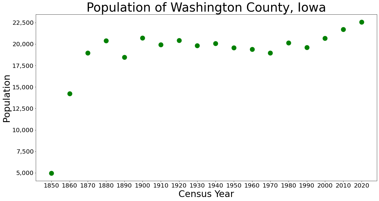
As of the census of 2000, there were 20,670 people, 8,056 households, and 5,631 families residing in the county. The population density was 36 PD/sqmi. There were 8,543 housing units at an average density of 15 /sqmi. The racial makeup of the county was 97.04% White, 0.29% Black or African American, 0.19% Native American, 0.25% Asian, 0.03% Pacific Islander, 1.51% from other races, and 0.68% from two or more races. 2.73% of the population were Hispanic or Latino of any race.
There were 8,056 households, out of which 31.40% had children under the age of 18 living with them, 60.30% were married couples living together, 6.70% had a female householder with no husband present, and 30.10% were non-families. 26.40% of all households were made up of individuals, and 12.50% had someone living alone who was 65 years of age or older. The average household size was 2.50 and the average family size was 3.04.
In the county, the population was spread out, with 26.10% under the age of 18, 7.00% from 18 to 24, 26.80% from 25 to 44, 22.30% from 45 to 64, and 17.90% who were 65 years of age or older. The median age was 39 years. For every 100 females, there were 93.00 males. For every 100 females age 18 and over, there were 90.10 males.
The median income for a household in the county was $39,103, and the median income for a family was $45,636. Males had a median income of $29,592 versus $22,818 for females. The per capita income for the county was $18,221. About 5.10% of families and 7.60% of the population were below the poverty line, including 10.30% of those under age 18 and 7.30% of those age 65 or over.
Education
The county is served by 3 school districts
- Highland Community School District
- Mid-Prairie Community School District
- Washington Community School District.
Highland Community School District includes:
- Highland Elementary School
- Highland Middle School
- Highland High School
Communities
Cities
- Ainsworth
- Brighton
- Coppock
- Crawfordsville
- Kalona
- Keota (mostly in Keokuk County)
- Riverside
- Washington
- Wellman
- West Chester
Unincorporated communities
- Daytonville
- Grace Hill
- Haskins
- Lexington
- Nira
- Noble
- Richmond
- Rubio
- Titu
- Verdi
- Yatton
Townships
- Brighton
- Cedar
- Clay
- Crawford
- Dutch Creek
- English River
- Franklin
- Highland
- Iowa
- Jackson
- Lime Creek
- Marion
- Oregon
- Seventy-Six
- Washington
Population ranking
The population ranking of the following table is based on the 2020 census of Washington County.
† county seat
| Rank | City/Town/etc. | Municipal type | Population (2020 Census) |
|---|---|---|---|
| 1 | † Washington | City | 7,352 |
| 2 | Kalona | City | 2,630 |
| 3 | Wellman | City | 1,524 |
| 4 | Riverside | City | 1,060 |
| 5 | Brighton | City | 600 |
| 6 | Ainsworth | City | 511 |
| 7 | Crawfordsville | City | 277 |
| 8 | West Chester | City | 144 |
| 9 | Coppock (partially in Henry and Jefferson Counties) | City | 36 |
Politics
References
References
- "Washington County, Iowa".
- "2020 Census State Redistricting Data". United states Census Bureau.
- "Find a County". National Association of Counties.
- United States Office of Management and Budget. "Update of Statistical Area Definitions and Guidance on Their Uses".
- "Archived copy".
- "Washington County, Iowa Genealogy - FamilySearch Wiki".
- "Washington County – ''History''".
- "Washington County, Iowa".
- [https://archive.org/stream/illustratedhisto00intutt#page/656/mode/2up An illustrated history of the state of Iowa, being a complete civil, political, and military history of the state, from its first exploration down to 1875]. Archive.org. Retrieved September 5, 2013.
- (February 12, 2011). "US Gazetteer files: 2010, 2000, and 1990". [[United States Census Bureau]].
- "Population and Housing Unit Estimates Tables". United States Census Bureau.
- "U.S. Decennial Census". United States Census Bureau.
- "Historical Census Browser". University of Virginia Library.
- "Population of Counties by Decennial Census: 1900 to 1990". United States Census Bureau.
- "Census 2000 PHC-T-4. Ranking Tables for Counties: 1990 and 2000". United States Census Bureau.
- "State & County QuickFacts". United States Census Bureau.
- "Annual Estimates of the Resident Population for Counties: April 1, 2020 to July 1, 2023". United States Census Bureau.
- (2021). "2020 Decennial Census Demographic Profile (DP1)".
- (2021). "2020 Decennial Census Redistricting Data (Public Law 94-171)".
- (2023). "2020 Decennial Census Demographic and Housing Characteristics (DHC)".
- "Population & Housing Occupancy Status 2010". United States Census Bureau – American FactFinder.
- "U.S. Census website". United States Census Bureau.
- Education, Iowa Department of. (September 2008). "Web Report Engine - Address".
- "Highland Community School District". Highland Community School District.
- Leip, David. "Dave Leip's Atlas of U.S. Presidential Elections".
This article was imported from Wikipedia and is available under the Creative Commons Attribution-ShareAlike 4.0 License. Content has been adapted to SurfDoc format. Original contributors can be found on the article history page.
Ask Mako anything about Washington County, Iowa — get instant answers, deeper analysis, and related topics.
Research with MakoFree with your Surf account
Create a free account to save articles, ask Mako questions, and organize your research.
Sign up freeThis content may have been generated or modified by AI. CloudSurf Software LLC is not responsible for the accuracy, completeness, or reliability of AI-generated content. Always verify important information from primary sources.
Report