From Surf Wiki (app.surf) — the open knowledge base
Waite Park, Minnesota
City in Minnesota, United States
City in Minnesota, United States
| Field | Value |
|---|---|
| official_name | Waite Park |
| settlement_type | City |
| motto | "The City With A Smile" |
| image_map | Stearns_County_Minnesota_Incorporated_and_Unincorporated_areas_Waite_Park_Highlighted.svg |
| mapsize | 250px |
| map_caption | Location of Waite Park |
| within Stearns County and state of Minnesota | |
| subdivision_type | Country |
| subdivision_name | United States |
| subdivision_type1 | State |
| subdivision_name1 | Minnesota |
| subdivision_type2 | County |
| subdivision_name2 | Stearns |
| leader_title | Mayor |
| leader_name | Rick Miller |
| established_title | Incorporated |
| established_date | 1893 |
| unit_pref | Imperial |
| area_footnotes | |
| area_total_km2 | 32.92 |
| area_land_km2 | 32.71 |
| area_water_km2 | 0.22 |
| area_total_sq_mi | 12.71 |
| area_land_sq_mi | 12.63 |
| area_water_sq_mi | 0.08 |
| population_as_of | 2020 |
| population_est | 8360 |
| pop_est_as_of | 2021 |
| pop_est_footnotes | |
| population_footnotes | |
| population_total | 8341 |
| population_density_km2 | 255.02 |
| population_density_sq_mi | 660.52 |
| timezone | CST |
| utc_offset | -6 |
| timezone_DST | CDT |
| utc_offset_DST | -5 |
| elevation_footnotes | |
| elevation_ft | 1089 |
| coordinates | |
| postal_code_type | ZIP codes |
| postal_code | 56387, 56388 |
| area_code | 320 |
| blank_name | FIPS code |
| blank_info | 27-67612 |
| blank1_name | GNIS feature ID |
| blank1_info | 2397165 |
| website |
within Stearns County and state of Minnesota
Waite Park is a city in Stearns County, Minnesota, United States. The population was 8,341 at the 2020 census.
History
Waite Park was incorporated in 1893. It was named for Henry Chester Waite, a state legislator. A post office was established at Waite Park in 1897, and remained in operation until 1972.
Geography
According to the United States Census Bureau, the city has an area of 8.94 sqmi; 8.90 sqmi is land and 0.04 sqmi is water.
Minnesota State Highway 23 and County 75 are two of Waite Park's main routes.
Minnesota Highway 15 skirts Waite Park's southeastern border. Interstate Highway 94 is immediately southwest of Waite Park.
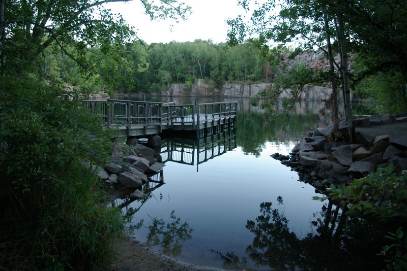
Waite Park borders the west side of St. Cloud. Stearns County Quarry Park, a former granite quarry, is on Waite Park's south side.
"The Ledge", a city-owned 6,000-seat outdoor amphitheater, opened in Waite Park in 2021. It hosts national acts, smaller concerts, and community events.
Demographics
|align-fn=center 2020 Census
2020 census
| Race / Ethnicity | title=HISPANIC OR LATINO, AND NOT HISPANIC OR LATINO BY RACE - 2000-Minnesota | url=https://play.google.com/books/reader?id=bliorXz9m0cC&pg=GBS.PA265&hl=en | website=Google Books}} | title=P2 HISPANIC OR LATINO, AND NOT HISPANIC OR LATINO BY RACE - 2010: DEC Redistricting Data (PL 94-171) - Waite Park, Minnesota | url=https://data.census.gov/table?q=p2&g=1600000US2767612&tid=DECENNIALPL2010.P2 | website=United States Census Bureau}} | title=P2 HISPANIC OR LATINO, AND NOT HISPANIC OR LATINO BY RACE - 2020: DEC Redistricting Data (PL 94-171) - Waite Park, Minnesota | url=https://data.census.gov/table?q=p2&g=1600000US2767612&tid=DECENNIALPL2020.P2 | website=United States Census Bureau}} | % 2000 | % 2010 | % 2020 |
|---|---|---|---|---|---|---|---|---|---|---|---|---|
| White alone (NH) | 6,047 | 5,531 | 4,809 | 92.07% | 82.37% | 57.66% | ||||||
| Black or African American alone (NH) | 46 | 435 | 2,199 | 0.70% | 6.48% | 26.36% | ||||||
| Native American or Alaska Native alone (NH) | 32 | 35 | 40 | 0.49% | 0.52% | 0.48% | ||||||
| Asian alone (NH) | 230 | 240 | 202 | 3.50% | 3.57% | 2.42% | ||||||
| Pacific Islander alone (NH) | 3 | 1 | 3 | 0.05% | 0.02% | 0.04% | ||||||
| Some Other Race alone (NH) | 2 | 10 | 23 | 0.03% | 0.15% | 0.28% | ||||||
| Mixed Race/Multi-Racial (NH) | 76 | 161 | 251 | 1.16% | 2.40% | 3.01% | ||||||
| Hispanic or Latino (any race) | 132 | 302 | 814 | 2.01% | 4.50% | 9.76% | ||||||
| Total | 6,568 | 6,715 | 8,341 | 100.00% | 100.00% | 100.00% |
Note: the US Census treats Hispanic/Latino as an ethnic category. This table excludes Latinos from the racial categories and assigns them to a separate category. Hispanics/Latinos can be of any race.
2010 census
As of the census of 2010, there were 6,715 people, 3,127 households, and 1,538 families living in the city. The population density was 754.5 PD/sqmi. There were 3,424 housing units at an average density of 384.7 /sqmi. The racial makeup of the city was 83.6% White, 6.6% African American, 0.7% Native American, 3.6% Asian, 2.7% from other races, and 2.9% from two or more races. Hispanic or Latino of any race were 4.5% of the population.
There were 3,127 households, of which 22.7% had children under the age of 18 living with them, 32.9% were married couples living together, 10.9% had a female householder with no husband present, 5.4% had a male householder with no wife present, and 50.8% were non-families. 38.0% of all households were made up of individuals, and 14.6% had someone living alone who was 65 years of age or older. The average household size was 2.12 and the average family size was 2.83.
The median age in the city was 32.6 years. 19.8% of residents were under the age of 18; 16.3% were between the ages of 18 and 24; 26.6% were from 25 to 44; 20.1% were from 45 to 64; and 17.4% were 65 years of age or older. The gender makeup of the city was 47.6% male and 52.4% female.
2000 census
As of the census of 2000, there were 6,568 people, 2,967 households, and 1,536 families living in the city. The population density was 841.0 PD/sqmi. There were 3,065 housing units at an average density of 392.5 /sqmi. The racial makeup of the city was 92.74% White, 0.72% African American, 0.56% Native American, 3.50% Asian, 0.05% Pacific Islander, 1.20% from other races, and 1.23% from two or more races. Hispanic or Latino of any race were 2.01% of the population.
There were 2,967 households, out of which 23.8% had children under the age of 18 living with them, 36.5% were married couples living together, 10.1% had a female householder with no husband present, and 48.2% were non-families. 32.1% of all households were made up of individuals, and 10.4% had someone living alone who was 65 years of age or older. The average household size was 2.19 and the average family size was 2.80.
In the city, the population was spread out, with 19.6% under the age of 18, 21.2% from 18 to 24, 30.1% from 25 to 44, 16.0% from 45 to 64, and 13.1% who were 65 years of age or older. The median age was 29 years. For every 100 females, there were 94.9 males. For every 100 females age 18 and over, there were 93.0 males.
The median income for a household in the city was $33,803, and the median income for a family was $43,415. Males had a median income of $27,066 versus $21,481 for females. The per capita income for the city was $17,796. About 7.9% of families and 12.1% of the population were below the poverty line, including 20.8% of those under age 18 and 4.7% of those age 65 or over.
Government
In the 2020 presidential election, Joe Biden won a 3% majority of Waite Park votes. In 2016, Donald Trump won by a 13% margin.
Education
Waite Park is in the St. Cloud Area School District.
Most residents are zoned to Discovery Elementary School, while some blocks north of 3rd Street are zoned to Westwood Elementary School. The zoned middle school is North Middle School, and the zoned high school is Apollo High School.
Waite Park was formerly home to the St. Cloud area campus of Globe University/Minnesota School of Business, a private career college.
References
References
- "2020 U.S. Gazetteer Files". United States Census Bureau.
- "U.S. Census website". [[United States Census Bureau]].
- {{GNIS. 2397165
- "Explore Census Data". [[United States Census Bureau]].
- Upham, Warren. (1920). "Minnesota Geographic Names: Their Origin and Historic Significance". Minnesota Historical Society.
- "Stearns County". Jim Forte Postal History.
- "US Gazetteer files 2010". [[United States Census Bureau]].
- Kelly Smith, [https://www.startribune.com/quarry-park-near-st-cloud-celebrates-20-years-this-month-as-it-grows-in-popularity/484995751/ "Quarry Park near St. Cloud celebrates 20 years this month as it grows in popularity It draws an estimated 150,000 visitors each year, a turnout that keeps growing.]", Star Tribune, June 9, 2018.
- [https://www.theledgeamp.com/ The Ledge Amphitheatre website]
- (July 4, 2022). "City and Town Population Totals: 2020-2021". United States Census Bureau.
- United States Census Bureau. "Census of Population and Housing".
- "HISPANIC OR LATINO, AND NOT HISPANIC OR LATINO BY RACE - 2000-Minnesota".
- "P2 HISPANIC OR LATINO, AND NOT HISPANIC OR LATINO BY RACE - 2010: DEC Redistricting Data (PL 94-171) - Waite Park, Minnesota".
- "P2 HISPANIC OR LATINO, AND NOT HISPANIC OR LATINO BY RACE - 2020: DEC Redistricting Data (PL 94-171) - Waite Park, Minnesota".
- [https://www.sctimes.com]. "Which St. Cloud suburb went for Democrat Joe Biden? And other election take-aways", Nora Hertel, Government Watchdog Report, St Cloud Times, November 14, 2020
- "2020 CENSUS - SCHOOL DISTRICT REFERENCE MAP: Stearns County, MN". [[U.S. Census Bureau]].
- "Elementary Attendance Areas". [[St. Cloud Area School District]].
- "WESTWOOD Versatrans Base Map". [[St. Cloud Area School District]].
- "NORTH Versatrans Base Map". [[St. Cloud Area School District]].
- "APOLLO Versatrans Base Map". [[St. Cloud Area School District]].
This article was imported from Wikipedia and is available under the Creative Commons Attribution-ShareAlike 4.0 License. Content has been adapted to SurfDoc format. Original contributors can be found on the article history page.
Ask Mako anything about Waite Park, Minnesota — get instant answers, deeper analysis, and related topics.
Research with MakoFree with your Surf account
Create a free account to save articles, ask Mako questions, and organize your research.
Sign up freeThis content may have been generated or modified by AI. CloudSurf Software LLC is not responsible for the accuracy, completeness, or reliability of AI-generated content. Always verify important information from primary sources.
Report