From Surf Wiki (app.surf) — the open knowledge base
Waimate
| Field | Value |
|---|---|
| name | Waimate |
| type | Town |
| mapframe | yes |
| mapframe-zoom | 6 |
| coordinates | |
| subdivision_type | Country |
| subdivision_name | New Zealand |
| subdivision_type2 | Island |
| subdivision_name2 | South Island |
| subdivision_type3 | District |
| subdivision_name3 | Waimate District |
| subdivision_type4 | Ward |
| subdivision_name4 | Waimate Ward |
| seat_type | Electorates |
| seat | |
| leader_title | Territorial authority |
| leader_name | Waimate District Council |
| leader_title1 | Regional council |
| leader_name1 | Environment Canterbury |
| leader_title2 | Mayor of Waimate |
| leader_name2 | |
| leader_title3 | Waitaki MP |
| leader_name3 | |
| leader_title4 | Te Tai Tonga MP |
| leader_name4 | |
| total_type | Urban area |
| population_total | |
| population_as_of | |
| population_footnotes | |
| area_total_km2 | 8.01 |
| area_footnotes | |
| population_density_km2 | auto |
| postal_code_type | Postcode(s) |
| postal_code | 7924 |
| area_code | 03 |
| website |
the town in the South Island, New Zealand
| mapframe-zoom = 6
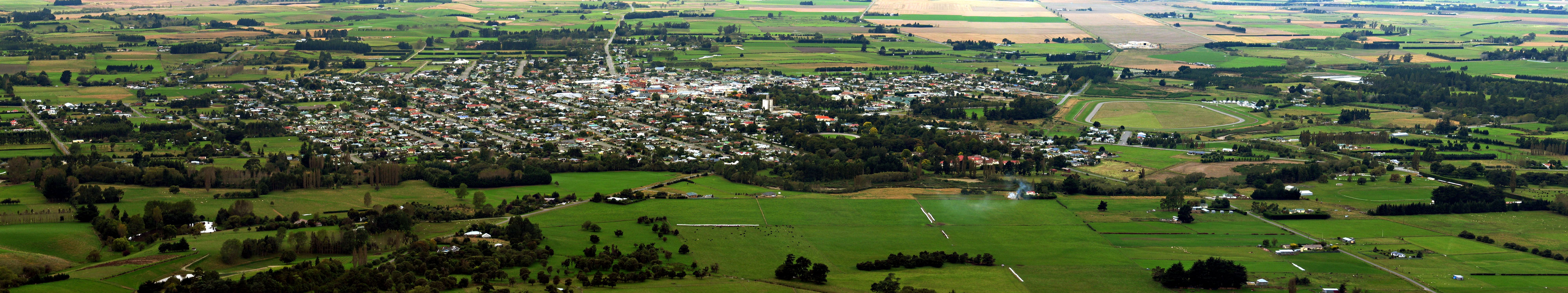
Waimate is a town in Canterbury, New Zealand, and the seat of Waimate District. It is situated just inland from the eastern coast of the South Island. The town is reached via a short detour west when travelling on State Highway One, the main north/south road. Waimate is 45.7 km south of Timaru, Canterbury's second city, 20 km north of the Waitaki River, which forms the border between Canterbury and the Otago province to the south, and 47.5 km north of Oamaru, the main town of the Waitaki District.
Waimate is well known for its population of Bennett's wallabies. These marsupials were introduced from Australia and now live wild in the countryside surrounding the town. It is also recognised for the White Horse Monument, which is a silhouette of a white horse that can be seen on the hills behind the town. It commemorates the Clydesdale horses that helped breaking in the land in earlier days. Visitors to the monument's lookout are rewarded with panoramic views of the town and the district's green plains out towards the Pacific Ocean.
History
From 1877 until 1966, Waimate was served by the Waimate Branch, a branch line railway that connected with the Main South Line some seven kilometres east in Studholme. For roughly seventy years ending in 1953, the line ran beyond Waimate to Waihao Downs. When the branch line was closed on 31 March 1966, Waimate became the first major town in New Zealand to lose its railway connection.
Geography
The Waimate District is bounded by the Waitaki River in the south, the Pareora River in the north and the Hakataramea Valley to the west. The district is a very productive agricultural area with a mix of pastoral, cropping, dairy farming, fruit and vegetable growing.
The Waihao River, which starts in the Hunter Hills catchment area runs eastwards on the southern side of the Waimate township joining with the Waimate Creek. They both eventually end up discharging very close to the sea into the Wainono Dead Arm, which then flows into the Wainono Lagoon near Studholme.
Water quality issues
Rising nitrate levels in the source water for the Lower Waihao rural water supply were observed by Waimate District Council in October 2024, and in December 2024 a do-not-drink notice was issued for the area.
Climate
| Jan record high C = 36.1 | Feb record high C = 39.0 | Mar record high C = 32.5 | Apr record high C = 30.4 | May record high C = 27.5 | Jun record high C = 23.4 | Jul record high C = 21.3 | Aug record high C = 23.4 | Sep record high C = 30.0 | Oct record high C = 32.2 | Nov record high C = 31.9 | Dec record high C = 34.8 | year record high C = 39.0 |Jan record low C = 1.4 |Feb record low C = 1.0 |Mar record low C = -3.0 |Apr record low C = -3.2 |May record low C = -6.2 |Jun record low C = -7.5 |Jul record low C = -8.5 |Aug record low C = -10.0 |Sep record low C = -6.5 |Oct record low C = -3.3 |Nov record low C = -1.7 |Dec record low C = 0.6 |year record low C = -10.0 |access-date = 19 May 2024}}{{cite web |access-date = 20 Jun 2024}}{{cite web |access-date = 5 Sep 2024}}{{cite web |access-date = 16 Jan 2025}}
Demographics
Waimate is described as a small urban area by Statistics New Zealand and covers 8.01 km2. It had an estimated population of as of with a population density of people per km2.
Waimate had a population of 3,456 at the 2018 New Zealand census, an increase of 171 people (5.2%) since the 2013 census, and an increase of 168 people (5.1%) since the 2006 census. There were 1,602 households, comprising 1,638 males and 1,815 females, giving a sex ratio of 0.9 males per female, with 474 people (13.7%) aged under 15 years, 465 (13.5%) aged 15 to 29, 1,374 (39.8%) aged 30 to 64, and 1,143 (33.1%) aged 65 or older.
Ethnicities were 94.4% European/Pākehā, 7.6% Māori, 0.8% Pasifika, 1.7% Asian, and 1.5% other ethnicities. People may identify with more than one ethnicity.
The percentage of people born overseas was 12.0, compared with 27.1% nationally.
Although some people chose not to answer the census's question about religious affiliation, 49.0% had no religion, 37.8% were Christian, 0.5% had Māori religious beliefs, 0.3% were Buddhist and 2.1% had other religions.
Of those at least 15 years old, 243 (8.1%) people had a bachelor's or higher degree, and 1,005 (33.7%) people had no formal qualifications. 213 people (7.1%) earned over $70,000 compared to 17.2% nationally. The employment status of those at least 15 was that 1,056 (35.4%) people were employed full-time, 405 (13.6%) were part-time, and 99 (3.3%) were unemployed.
| Name | Area (km2) | Population | Density (per km2) | Households | Median age | Median income | New Zealand | 37.4 years | $31,800 | |
|---|---|---|---|---|---|---|---|---|---|---|
| Waimate North | 4.46 | 507 | 114 | 237 | 56.5 years | $22,900 | ||||
| Waimate West | 0.93 | 1,335 | 1,435 | 600 | 51.5 years | $22,400 | ||||
| Waimate East | 2.60 | 1,614 | 621 | 765 | 55.2 years | $22,500 |
Nearby communities
- Glenavy
- Hook
- Hunter
- Ikawai
- Makikihi
- Morven
- Otaio
- Saint Andrews
- Studholme
- Waihao Downs
- Waihaorunga
- Waituna
Economy
Like much of rural New Zealand, Waimate suffered from an economic downturn in the 1980s, with the closure of the dairy factory and a number of sawmills. For the last decade of the 20th century the biggest employers in the district were two furniture manufacturers, a vegetable processing plant and a factory making French fries and other potato products at Makikihi. All but the latter closed within the first few years of the 21st century. However, a newly developed large scale sawmill and the development of a large milk powder factory, coupled with the wealth of dairy farms and the nationwide real estate bubble of 2003–2007, saw a renewed confidence in Waimate.
Education
Further Information: List of schools in Canterbury, New Zealand#Waimate District
Waimate Main School and Waimate Centennial School are contributing primary schools for students in years 1 to 6, with rolls of and students, respectively. Waimate Main opened in 1867 as Waimate Primary. Waimate Centennial opened in 1955 and catered for years 1 to 8 until 1982, when it reduced to years 1 to 6.
Waituna Creek School is a rural full primary about 6 kilometres northwest of Waimate. It caters for students in years 1 to 8 and has a roll of . It was established in 1879.
St Patrick's School is a Catholic state-integrated full primary for years 1 to 8 with a roll of students. The school website says it was first opened in the late 1880s, and the school celebrated 125 years of Catholic education in Waimate in 2005. The New Zealand Tablet reported that St Patrick's School opened during 1881.
Waimate High School is a secondary school for years 7 to 13 with a roll of students. Waimate District High School opened in 1883. It became Waimate High on a new site in 1929, and in 1982 it expanded to also take year 7 and 8 students.
Notable people from Waimate
- Eric Batchelor, a decorated Commonwealth NCO who served in World War II
- Ken Catran, novelist and screenwriter
- Margaret Cruickshank (1873–1918), the second woman to graduate in medicine in New Zealand and the first New Zealand woman to register and practise as a general practitioner. Although not born in Waimate, she spent her professional career there and her achievement is celebrated with a monument of her in the middle of the township.
- Mary Gorman, World War I nurse who died in the sinking of the SS Marquette
- A. M. Hamilton, notable for building the Hamilton Road through Kurdistan and designing the Callender-Hamilton bridge system
- Major General Howard Kippenberger, officer commanding New Zealand forces in North Africa during World War II. Though not born in Waimate, his father bought a farm there when he was young and he spent much of his early childhood there
- Norman Kirk, 29th Prime Minister of New Zealand, 1972–1974
- Neill Rattray (1896–1964), farmer, war veteran, and member of the New Zealand Legislative Council
- Jim Sheddan (1918–2010), flying ace of the Royal New Zealand Air Force during the Second World War
- Michael Studholme, the first European settler in the region
- Sir William Maxwell Manchester (1913–2001), founding plastic surgeon at Middlemore Hospital, Auckland in 1950
- Kaylee Bell, New Zealand country singer-songwriter
Notable places
A statue of Zealandia, a female allegorical representation of New Zealand similar to Great Britain's Britannia, is located just off the main street. Only three Zealandia statues exist in the whole country: the one at Waimate, another at Palmerston in Otago, and a third in Auckland. The Waimate and Palmerston statues were erected as Boer War memorials, and the one in Auckland to commemorate troops who fought against Māori in the New Zealand Wars.{{cite web|title=New Zealand Wars memorial statue defaced by anti-colonial activists|date= 11 January 2018
St Patrick's Basilica Catholic Church, located on Timaru Rd, was designed in 1908 by Francis Petre and is considered his most original design. St. Augustine's Anglican Church, located on John Street in Waimate, was designed in 1872 by Benjamin Mountfort.
Waihao marae, a marae (tribal meeting ground) of Ngāi Tahu and its Te Rūnanga o Waihao branch, is located in the Waimate district. It includes Centennial Memorial Hall, a wharenui (traditional meeting house).
Waimate Museum, located in Shearman St, was designed in 1878 by P.M.F. Burrows. Arcadia Theatre was originally built as Quinn's Arcade in 1906.
The White Horse Monument, built in 1968, is located at Centrewood Park, on a hill overlooking the town. The monument was created by farmers Norman and Betty Hayman to commemorate the contribution of Clydesdale and Shire horses to the district’s farming economy.
Sport
Waimate Rugby Football Club has teams competing in the South Canterbury rugby competitions. The club is affiliated with the South Canterbury Rugby Football Union.
Waimate Golf Club is on the outskirts of the town.
Events
- March Hare Motorcycle Rally, annually, first weekend of March
- Waimate 50 Street Race, annually, October
- Waimate Strawberry Fare, annually, second weekend in December
- Waimate Shears, annually, October
- Waimate Rodeo, annually, 27 December
- Claytons Debating Tournament, annually, July–August
- Waimate Museum Bookarama, annually, Labour Weekend
- Waimate Edwardian Heritage Celebrations, annually, second weekend in March
Movies and film
- The Waimate Conspiracy (2006) was filmed in Waimate.
Sister cities
-
Bourail, France
-
Milton-Freewater, USA
References
References
- Green, Kate. (2 December 2024). "Do not drink water notice issued in Waimate, South Canterbury".
- (2 December 2024). "'Do not drink': Warning over nitrate levels in Waimate water".
- "ArcGIS Web Application".
- {{NZ census 2018. Waimate North (342500), Waimate West (342700) and Waimate East (342800)
- {{NZ census place summary 2018. waimate-north. Waimate North
- {{NZ census place summary 2018. waimate-west. Waimate West
- {{NZ census place summary 2018. waimate-east. Waimate East
- {{TKI. 3574. Waimate Main School
- {{TKI. 3573. Waimate Centennial School
- "South Canterbury Schools". South Canterbury branch, New Zealand Society of Genealogists.
- "Nau Mai Haere Mai! Welcome to Waimate Centennial!". Waimate Centennial School.
- {{TKI. 3579. Waituna Creek School
- {{TKI. 3539. St Patrick's School
- "About Us". St Patrick's School.
- Foley, John. (2005). "125 years of Catholic education in Waimate, 1880–2005 history of St. Patrick's School". St Patrick's School.
- (20 January 1882). "St. Patrick's School Waimate". New Zealand Tablet.
- {{TKI. 362. Waimate High School
- (2020). "Waimate High School Charter". Waimate High School.
- "CRUIKSHANKS, Margaret Barnet".
- Scholefield, Guy. (1951). "Who's Who in New Zealand, 1951". [[A.H. & A.W. Reed]].
- "Manchester, Sir William Maxwell (1913–2001)". Royal College of Surgeons.
- (4 March 2015). "The Churches of Waimate, South Canterbury".
- "Te Kāhui Māngai directory". [[Te Puni Kōkiri]].
- "Māori Maps". Te Potiki National Trust.
- School, New Zealand Broadcasting. (2024-11-26). "The White Horse of Waimate".
- "The White Horse".
- "Sportsground.com – Home".
- "Home – Waimate Golf Club". Waimate Golf Club.
- "The Waimate Conspiracy".
- (2017-10-29). "Sister Cities – NZ cities and their sisters".
This article was imported from Wikipedia and is available under the Creative Commons Attribution-ShareAlike 4.0 License. Content has been adapted to SurfDoc format. Original contributors can be found on the article history page.
Ask Mako anything about Waimate — get instant answers, deeper analysis, and related topics.
Research with MakoFree with your Surf account
Create a free account to save articles, ask Mako questions, and organize your research.
Sign up freeThis content may have been generated or modified by AI. CloudSurf Software LLC is not responsible for the accuracy, completeness, or reliability of AI-generated content. Always verify important information from primary sources.
Report