From Surf Wiki (app.surf) — the open knowledge base
Venetian Lagoon
Enclosed bay in which the city of Venice is situated

Enclosed bay in which the city of Venice is situated
| Field | Value |
|---|---|
| name | Venetian Lagoon |
| other_name | Venice Lagoon |
| Lagoon of Venice | |
| native_name | |
| image | Porto di Lido-San Nicolò.jpg |
| caption | Aerial view of the Venetian Lagoon, showing many of the islands including Venice itself, center rear, with the bridge to the mainland |
| basin_countries | Italy |
| location | Venice, Veneto, Italy |
| coords | |
| outflow | Adriatic Sea |
| date-built | |
| date-flooded | |
| area | 550 km2 |
| depth | 10.5 m |
| max-depth | 21.5 m |
| pushpin_map | Venetian Lagoon |
| elevation | 3 m |
| cities | Venice, Campagna Lupia, Cavallino-Treporti, Chioggia, Codevigo, Jesolo, Mira, Musile di Piave, Quarto d'Altino, San Donà di Piave |
| embedded | {{Designation list |
| embed | yes |
| designation1 | Ramsar |
| designation1_offname | Laguna di Venezia: Valle Averto |
| designation1_date | 11 April 1989 |
| designation1_number | 423}} |
Lagoon of Venice | date-built = | date-flooded = | max-depth = 21.5 m
The Venetian Lagoon, also Venice Lagoon or Lagoon of Venice, is an enclosed bay of the Adriatic Sea, in northern Italy, in which the city of Venice is situated. Its name, from a Venetian derivative of Latin lacus , has become the generalized English term for any enclosed, shallow embayment of salt watera lagoon.
Location
The Venetian Lagoon stretches from the River Sile in the north to the Brenta in the south, with a surface area of around 550 km2. It is around 8% land, including Venice itself and many smaller islands. About 11% is permanently covered by open water, or canals, as the network of dredged channels are called, while around 80% consists of mud flats, tidal shallows and salt marshes. The Lagoon is the largest wetland in the Mediterranean Basin.
It is connected to the Adriatic Sea by three inlets: Lido, Malamocco and Chioggia. Situated at one end of a largely enclosed sea, the lagoon is subject to large variations in its water level. The most extreme are the spring tides known as the acqua alta (Italian for "high water"), which regularly flood much of Venice.
The nearby Marano-Grado Lagoon, with a surface area of around 160 km2, is the northernmost lagoon in the Adriatic Sea and is sometimes called the "twin sister of the Venice lagoon".
Development
The Lagoon of Venice is the most important survivor of a system of estuarine lagoons that in Roman times extended from Ravenna north to Trieste. In the fifth and sixth centuries, the Lagoon gave security to Romanised people fleeing invaders (mostly the Huns and the Lombards). Later, it provided naturally protected conditions for the growth of the Venetian Republic and its maritime empire. It still provides a base for a seaport, the Venetian Arsenal, and for fishing, as well as a limited amount of hunting and the newer industry of fish farming.
The Lagoon was formed about six to seven thousand years ago, when the marine transgression following the Ice Age flooded the upper Adriatic coastal plain. Deposition of river sediments compensated for the sinking coastal plain, and coastwise drift from the mouth of the Po tended to form sandbars that closed tidal inlets.

The present aspect of the Lagoon is the result of human intervention. In the fifteenth and sixteenth centuries, Venetian hydraulic projects designed to prevent the lagoon from turning into a marsh reversed the natural evolution of the Lagoon. Pumping of aquifers since the nineteenth century has increased subsidence. Many of the Lagoon's islands had originally been marshy, but a gradual drainage programme rendered them habitable. Many of the smaller islands are entirely artificial, while some areas around the seaport of the Mestre are also reclaimed islands. The remaining islands—-including those of the coastal strip (Lido, Pellestrina and Treporti)—-are essentially dunes.
Venice Lagoon has been inhabited from the most ancient times, but it was only during and after the fall of the Western Roman Empire that people coming from the Venetian mainland settled in numbers large enough to found the city of Venice. Today, the main cities inside the lagoon are Venice (at the centre of it) and Chioggia (at the southern inlet); Lido di Venezia and Pellestrina are inhabited as well, but they are considered part of Venice. However, most of the inhabitants of Venice, as well as its economic core (its airport and harbor), are on the western border of the lagoon, around the former towns of Mestre and Marghera. There are also two towns at the northern end of the lagoon: Jesolo (a famous sea resort) and Cavallino-Treporti.
Ecosystem
Bottlenose dolphins occasionally enter the lagoon, possibly for feeding.
The level of pollution in the lagoon has long been a concern. The large phytoplankton and macroalgae blooms in the late 1980s proved particularly devastating. Researchers have identified the lagoon as one of the primary areas where non-indigenous species are introduced into the Mediterranean Sea.

Cruise ships crossing the Venetian Lagoon have contributed to air pollution, surface-water pollution, decreased water quality, erosion, and loss of landscape.
From 1987 to 2003, the Venice Lagoon was harmed by a reduction in nutrient inputs and by macroalgal biomasses caused by climate change, and by changes in the concentration and distribution of nitrogen, organic phosphorus and organic carbon in the upper sediments. At the same time, however, the seagrasses started a natural process of recolonization, helping to partially restore the pristine conditions of the marine ecosystem.
Islands

The Venice Lagoon is mostly included in the Metropolitan City of Venice, but the south-western area is part of the Province of Padua.
The largest islands or archipelagos by area, excluding coastal reclaimed land and the coastal barrier beaches:
- Venice 5.17 km
- Sant'Erasmo 3.26 km
- Murano 1.17 km
- Chioggia 0.67 km
- Giudecca 0.59 km
- Mazzorbo 0.52 km
- Torcello 0.44 km
- Sant'Elena 0.34 km
- La Certosa 0.24 km
- Burano 0.21 km
- Tronchetto 0.18 km
- Sacca Fisola 0.18 km
- San Michele 0.16 km
- Sacca Sessola 0.16 km
- Santa Cristina 0.13 km
Other inhabited islands include:
- Cavallino
- Lazzaretto Nuovo
- Lazzaretto Vecchio
- Lido
- Pellestrina
- Poveglia
- San Clemente
- San Francesco del Deserto
- San Giorgio in Alga
- San Giorgio Maggiore
- San Lazzaro degli Armeni
- Santa Maria della Grazia
- San Pietro di Castello
- San Servolo
- Santo Spirito
- Sottomarina
- Vignole
Notes
References
References
- "Laguna di Venezia: Valle Averto".
- Poggioli, Sylvia. (7 January 2008). "MOSE Project Aims to Part Venice Floods". [[NPR]].
- "Venice, Italy (1985–2003) - 25 Years of Landsat 5 - Landsat 5 showcase - Earth Watching".
- (2003). "The Lagoon of Venice: Geological Setting, Evolution and Land Subsidence". [[Episodes (journal).
- Heymans, J.J., Coll, M., Libralato, S., Morissette, L. and Christensen, V. (2014). "Global patterns in ecological indicators of marine food webs: a modelling approach". ''PLOS ONE'', '''9'''(4). doi:10.1371/journal.pone.0095845.
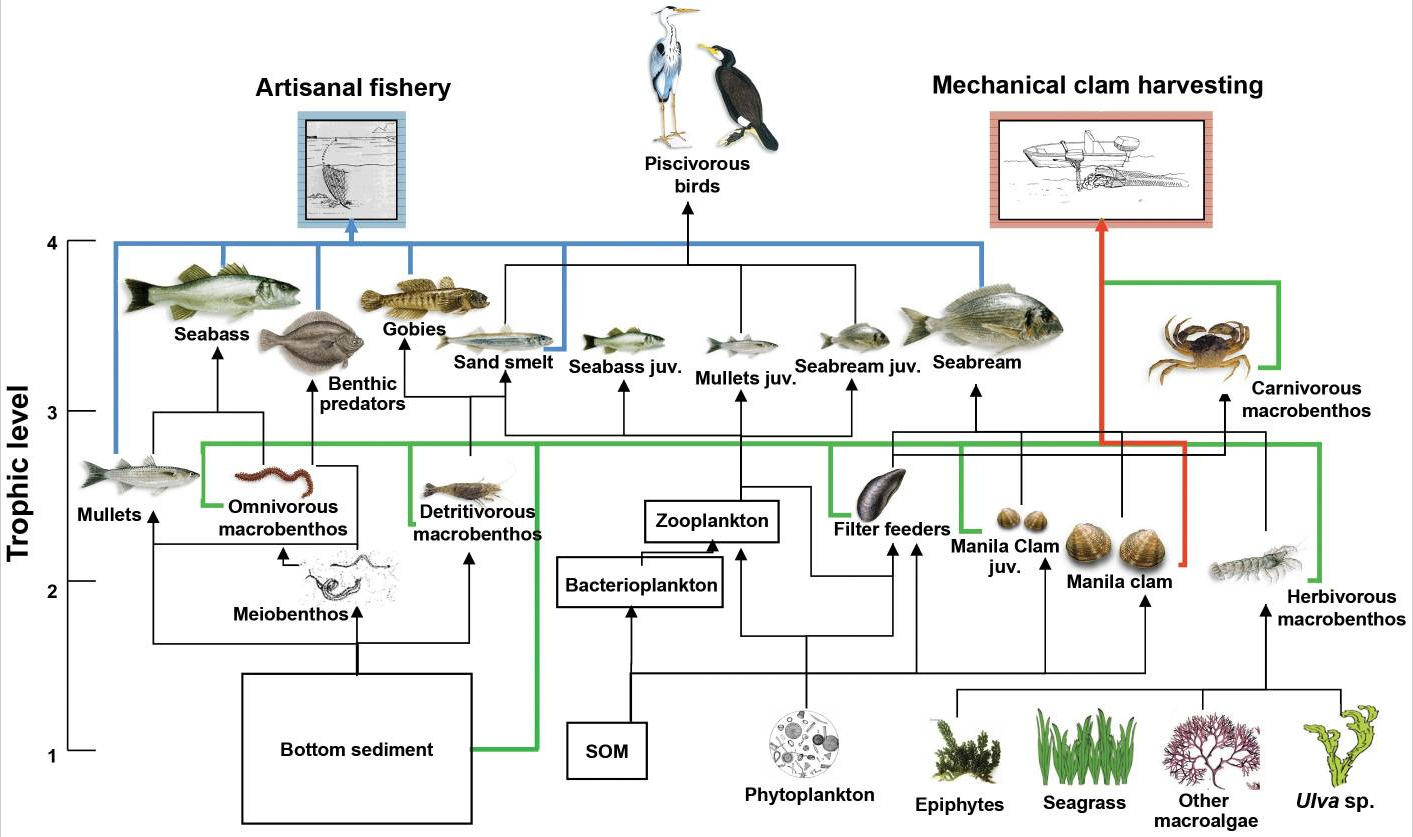
- Pranovi, F., Libralato, S., Raicevich, S., Granzotto, A., Pastres, R. and Giovanardi, O. (2003). "Mechanical clam dredging in Venice lagoon: ecosystem effects evaluated with a trophic mass-balance model". ''Marine Biology'', '''143'''(2): 393–403. doi:10.1007/s00227-003-1072-1.
- "Rare Report of a Bottlenose Dolphin Foraging in the Venice Lagoon, Italy". [[Tethys Research Institute]].
- (1971). "Observations of Dispersal Processes of Pollutants in Venice Lagoon and in the Po River Coastal Area". Société Royale des Sciences de Liège.
- (2000). "The Venice Lagoon Ecosystem: Inputs and Interactions Between Land and Sea". Parthenon.
- (1992). "Macroalgae, Nutrient Cycles, and Pollutants in the Lagoon of Venice". Estuaries.
- (2007). "Application of Biotic Indices and Relationship with Structural and Functional Features of Macrobenthic Community in the Lagoon of Venice: An Example over a Long Time Series of Data". Marine Pollution Bulletin.
- (2003). "Biological Invasions as a Component of Global Change in Stressed Marine Ecosystems". Marine Pollution Bulletin.
- (2015). "Current Status and Trends of Biological Invasions in the Lagoon of Venice, a Hotspot of Marine NIS Introductions in the Mediterranean Sea". Biological Invasions.
- EJOLT. "Cruise Ships impacting Venetian Lagoon, Italy {{!}} EJAtlas".
- Sonia Ceoldo. (2014). "Natural Recovery and Planned Intervention in Coastal Wetlands: Venice Lagoon (Northern Adriatic Sea, Italy) as a Case Study". The Scientific World Journal.
This article was imported from Wikipedia and is available under the Creative Commons Attribution-ShareAlike 4.0 License. Content has been adapted to SurfDoc format. Original contributors can be found on the article history page.
Ask Mako anything about Venetian Lagoon — get instant answers, deeper analysis, and related topics.
Research with MakoFree with your Surf account
Create a free account to save articles, ask Mako questions, and organize your research.
Sign up freeThis content may have been generated or modified by AI. CloudSurf Software LLC is not responsible for the accuracy, completeness, or reliability of AI-generated content. Always verify important information from primary sources.
Report