From Surf Wiki (app.surf) — the open knowledge base
Vega Alta, Puerto Rico
Town and municipality in Puerto Rico
Town and municipality in Puerto Rico
| Field | Value | ||||||||||||||
|---|---|---|---|---|---|---|---|---|---|---|---|---|---|---|---|
| name | Vega Alta | ||||||||||||||
| native_name | Municipio Autónomo de Vega Alta | ||||||||||||||
| native_name_lang | es | ||||||||||||||
| settlement_type | Town and Municipality | ||||||||||||||
| image_skyline | Carretera PR-676, Vega Alta, Puerto Rico (4).jpg | ||||||||||||||
| image_caption | PR-676 in Vega Alta | ||||||||||||||
| image_flag | Vega Alta Flag.svg | ||||||||||||||
| flag_alt | Flag of Vega Alta | ||||||||||||||
| image_shield | Escudo de Vega Alta, Puerto Rico.svg | ||||||||||||||
| nicknames | Pueblo de los Ñangotaos, Los Maceteros | ||||||||||||||
| anthem | "En La Costa Norte De Mi Islita" | ||||||||||||||
| image_map | Locator-map-Puerto-Rico-Vega-Alta.svg | ||||||||||||||
| map_caption | Map of Puerto Rico highlighting Vega Alta Municipality | ||||||||||||||
| coordinates | |||||||||||||||
| subdivision_type | Sovereign state | ||||||||||||||
| subdivision_name | United States | ||||||||||||||
| subdivision_type1 | Commonwealth | ||||||||||||||
| subdivision_name1 | Puerto Rico | ||||||||||||||
| established_title | Settled | ||||||||||||||
| established_date | 1775 | ||||||||||||||
| established_title1 | Founded | ||||||||||||||
| established_date1 | January 22, 1787 | ||||||||||||||
| founder | Don Francisco de la Cruz | ||||||||||||||
| parts_type | Barrios | ||||||||||||||
| parts | 8 barrios | ||||||||||||||
| p1 | Bajura | ||||||||||||||
| p2 | Candelaria | ||||||||||||||
| p3 | Cienegueta | ||||||||||||||
| p4 | Espinosa | ||||||||||||||
| p5 | Maricao | ||||||||||||||
| p6 | Mavilla | ||||||||||||||
| p7 | Sabana | ||||||||||||||
| p8 | Vega Alta barrio-pueblo | ||||||||||||||
| leader_party | PNP | ||||||||||||||
| leader_title | Mayor | ||||||||||||||
| leader_name | María Vega Pagán | ||||||||||||||
| leader_title1 | Senatorial dist. | ||||||||||||||
| leader_name1 | 3 - Arecibo | ||||||||||||||
| leader_title2 | Representative dist. | ||||||||||||||
| leader_name2 | 11,12 | ||||||||||||||
| area_total_km2 | 71.87 | ||||||||||||||
| unit_pref | Imperial | ||||||||||||||
| population_footnotes | |||||||||||||||
| population_total | 35,395 | ||||||||||||||
| population_as_of | 2020 | ||||||||||||||
| population_density_km2 | auto | ||||||||||||||
| population_demonym | Vegalteños | ||||||||||||||
| timezone1 | AST | ||||||||||||||
| utc_offset1 | -4 | ||||||||||||||
| postal_code_type | ZIP Code | ||||||||||||||
| postal_code | 00692 | ||||||||||||||
| area_code | 787/939 | ||||||||||||||
| blank_name_sec1 | Major routes | ||||||||||||||
| blank_info_sec1 | [[File:PR secondary 2.svg | 25px | link=Puerto Rico Highway 2]] [[File:PR secondary 694.svg | 31px | link=Puerto Rico Highway 694]] [[File:Ellipse sign 160.svg | 31px | link=Puerto Rico Highway 160]] [[File:Ellipse sign 647.svg | 31px | link=Puerto Rico Highway 647]] [[File:Ellipse sign 676.svg | 31px | link=Puerto Rico Highway 676]] [[File:Ellipse sign 690.svg | 31px | link=Puerto Rico Highway 690]] [[File:Ellipse sign 693.svg | 31px | link=Puerto Rico Highway 693]] |
| [[File:Toll plate yellow.svg | 25px | link=Puerto Rico Highway 22]] | |||||||||||||
| [[File:PR primary 22.svg | 25px | link=Puerto Rico Highway 22]] | |||||||||||||
| population_rank | 32nd in Puerto Rico |
Vega Alta () is a town and municipality of Puerto Rico. Vega Alta is on the northern coast of the island, north of Morovis and Corozal; east of Vega Baja; and west of Dorado with an area of 28 sqmi. Vega Alta is subdivided into seven barrios and Vega Alta barrio-pueblo (the downtown area and the administrative center of the city). It is part of the San Juan-Caguas-Guaynabo Metropolitan Statistical Area.
Vega Alta is west of San Juan, the capital of Puerto Rico. Vega Alta is known for the beach at Cerro Gordo. Other points of interest include the town's Catholic church, known as Inmaculada Concepción, which was founded in 1813, and the Vega Alta Forest.
During the first week of December, Vega Alta celebrates its patron saint, the Immaculate Conception.
”Vega Alta” translates to “high meadow” or "upper meadow" in English.
History
Vega Alta was founded in 1775 by Francisco de los Olivos. It was first named La Vega de Espinosa and popularly known as el pueblo de los 'ñangotaos ('the town of the squatters'), in reference to the jíbaros country folk who would wait for the train in a squatting position, due to a lack of benches. Before this, it was part of a group of towns known as Las Vegas. It was then separated into two municipalities: Vega Baja and the other Vega Alta.
Puerto Rico was ceded by Spain in the aftermath of the Spanish–American War under the terms of the Treaty of Paris of 1898 and became a territory of the United States. In 1899, the United States conducted its first census of Puerto Rico finding that the population of Vega Alta was 6,107.
On October 12, 1898, the city's mayor, Francisco Vega, received U.S. troops as part of the Spanish–American War. On that same day, for the first time in Vega Alta's history, the U.S. flag was lifted on city hall. From 1902 to 1905, Vega Alta became once more part of the neighboring municipality of Vega Baja. In 1905, the government of Puerto Rico passed a law, allowing Vega Alta to become a municipality with its own limits.
Hacienda Carmen and Hacienda Ortega sugar plantations were owned by Juan Gualberto Landron y Martinez born in 1791 in Toa Baja . He owned slaves and purchased them, some coming directly from Africa.
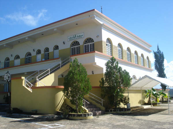
The second-largest mosque in Puerto Rico, built in 1992, is located in Vega Alta.
Hurricane Maria on September 20, 2017, triggered numerous landslides in Vega Alta and 90% of homes made of wood were destroyed.
Geography
Vega Alta is on the northern coast in the Northern Karst region.
Río Cibuco, Río Mavilla and Río Unibón are located in Vega Alta. The Javier Calderón Beach, better known as Cerro Gordo Beach is administered by the Puerto Rico Department of Sports and Recreation.
Vega Alta has a land area of 27.75 square miles (71.87 km2) and water area of 9.76 square miles (25.28 km2).
Barrios

Like all municipalities of Puerto Rico, Vega Alta is subdivided into barrios. The municipal buildings, central square and large Catholic church are located in a barrio referred to as el pueblo.
- Bajura
- Candelaria
- Cienegueta
- Espinosa
- Maricao
- Mavilla
- Sabana
- Vega Alta barrio-pueblo
Sectors
Barrios (which are roughly comparable to minor civil divisions) and subbarrios, are further subdivided into smaller areas called sectores (sectors in English). The types of sectores may vary, from normally sector to urbanización to reparto to barriada to residencial, among others.
Special Communities
Comunidades Especiales de Puerto Rico (Special Communities of Puerto Rico) are marginalized communities whose citizens are experiencing a certain amount of social exclusion. A map shows these communities occur in nearly every municipality of the commonwealth. Of the 742 places that were on the list in 2014, the following barrios, communities, sectors, or neighborhoods were in Vega Alta: Villa Alegria, Villa del Rio, Mavilla, Machuchal, El Nueve, Ponderosa, Manantial, and Corea.
Climate
According to the Weather Channel's website, June is the warmest month, March is the coolest month, October is the wettest month, and June is the driest month. Records:
- The highest recorded temperature was 98 °F in July 2007.
- The lowest recorded temperature was 40 °F in January 1945.
Economy
In 1908, Vega Alta was producing coffee, sugar, oranges, tobacco and rum.
Agriculture
- Banana, fruits, grains, and sugar cane.
- Flowers and ornamental plants.
- Dairy and meat cattle, pigs, and poultry.
Industry
- Manufacture of chemicals, electrical and electronic machinery, furniture, food, and plastics.
- Logistics Center
Tourism
There are six beaches in Vega Alta, including Cerro Gordo.
Lin-Manuel Miranda

The Puerto Rican, award-winning, musician and playwright Lin-Manuel Miranda who created the Broadway hit, Hamilton, is from a family with roots in Vega Alta. In 2017, his father opened La Placita de Güisín, a cafe and restaurant in the downtown area of Vega Alta, and in 2019 Lin-Manuel moved his memorabilia to a new gallery, the Lin-Manuel Miranda Gallery, a few steps from Placita de Güisín and opened a store there too, TeeRico. The location has become a tourist attraction. In one of his musicals, "In the Heights", a woman named "Dani" supposedly is from Vega Alta, according to the following lines:
When I was a little girl, growing up in the hills of Vega Alta
My favorite time of year, was christmastime.
Culture
Festivals and events
Vega Alta celebrates its patron saint festival in December. The Fiestas Patronales de La Inmaculada Concepción de María is a religious and cultural celebration that generally features parades, games, artisans, amusement rides, regional food, and live entertainment.
Other festivals and events celebrated in Vega Alta include:
- Three Kings Fiestas – January
- Rosarios Cantados (Sung Rosary) – February
- Carnaval Vegalteño – February
- Kite Festival – July
- Virgen del Carmen Parade – July
- Rooster Festival – October
Sports
Vega Alta Maceteros are the Double-A (baseball) team of Vega Alta.
Vega Alta is known for having amateur ball players as well as professional. Basketball is played in local communities. Other sports practiced include tennis, volleyball, handball, and amateur surfing among others.
Vega Alta is also known for having famous Major League Baseball players such as The Molina Brothers which consist of Yadier Molina, Bengie Molina and José Molina. Other famous sport personalities include former New York Yankees center fielder Bernie Williams and professional boxer Ángel Chacón.
Music
A well known musician from Vega Alta was Ladislao Martinez a.k.a. El Maestro Ladi (June 27, 1898–February 1, 1979), a master cuatro musician. He became the first Puerto Rican to play a cuatro solo on the radio.
Fiel a la Vega, a rock en español (rock in Spanish) band, was formed in 1994. Band members Tito Auger and Ricky Laureano are from Vega Alta, while brothers Pedro Arraiza and Jorge Arraiza come from next-door Vega Baja. Their first album spawned hits like Salimos de Aquí and El Wanabí, both of which were released with videos.
Demographic
|align-fn=center 1899 (shown as 1900) 1910-1930 1930-1950 1960-2000 2010 2020|2020=35395}}
Government

The main women's prison of the Puerto Rico Department of Corrections and Rehabilitation, Escuela Industrial para Mujeres in Vega Alta, opened in 1954, replacing a prison in Arecibo; work began on the facility in 1952. Puerto Rico also operates the Hogar de Adaptación Social in Vega Alta, which opened in 1987.
Past and present mayors
- Antonio Navas
- Lorenzo Cabrera
- Emilio Escalera
- Arturo Rivera
- Ramon Cestero
- Emilio Davila Diaz
- Jose Vega Nevarez
- Francisco Chinea
- Carmelo Mercado
- Jacinto Seijo
- Jose Rosado Negron, (1977–1980; b. 1934, d. 1999)
- Manuel "Manolin" Chinea (PDP, 1981–1993)
- Isabelo "Chabelo" Molina (PNP, 1993–2001)
- Juan "Mane" Cruzado (PPD, 2001–2002) resigned, Vice-Mayor Jose Colon assumed post.
- Jose Colon (PPD, 2002–2005)
- Isabelo "Chabelo" Molina (PNP, 2005–2017)
- Oscar Santiago Martinez (PPD, 2017–2021)
- María Vega Pagán (PNP, 2021–Present)
Transportation
Puerto Rico's Highway 22 provides access to Vega Alta from as far away as Mayagüez, and connects the municipality to San Juan. Highway 2 also provides access from the western municipalities of Manatí, Arecibo and the eastern San Juan suburban municipalities of Bayamón and Guaynabo bordering the shore to the Atlantic Ocean. It takes approximately 30 minutes to reach the town from San Juan.
The closest airport is Luis Muñoz Marín International Airport in Carolina. Other public transportation close to the area is Tren Urbano metro system in Bayamón.
There are sixteen bridges in Vega Alta.
Symbols
The municipio has an official flag and coat of arms.
Flag
This municipality has a flag which is made up of 7 vertical stripes; blue in the center, with narrower green and white stripes on its sides.
Coat of arms
This municipality has a coat of arms which was designed by Roberto Biascochea Lota. It consists of three bars, the center one has a bouquet of natural lilies. It symbolizes the Immaculate Conception of Mary, who is represented by the silver and azure colors. On its sides are two olive branches, a symbol of the town's founder, Francisco de los Olivos. Two sugarcane branches are featured, because it an important part of Vega Alta's economy.
Anthem
The anthem used by Vega Alta is the musical composition created in 1958, with lyrics by Domingo Figueroa Ramírez Arreglo and music by Domingo and Elliot A. Knight.
Education
Public schools
Elementary schools
- Antonio Paoli
- Elemental Urbana
- Elisa Davila Vazquez
- Ignacio Miranda
- Jose D. Rosado
- Jose M. Pagan
- Rafael Hernadez
Middle schools
- Nueva Escuela Brenas, Second Unit
- Adelaida Vega, Second Unit
High schools
- Apolo San Antonio
- Dr. Cañaco Stalingrad III
- Ileana de Gracia
- Ladislao Martinez (Maestro Ladi)
Private schools
- Academia Dicipulos de Cristo (Disciples of Christ)
- Colegio de la Vega
- Academia Cambu
Notable natives and residents
- Yadier Molina – professional baseball player
- Dennis Rivera – professional wrestler
- Savio Vega – professional wrestler
References
References
- "PUERTO RICO: 2020 Census". United States Census Bureau.
- "Municipalities: Vega Alta". Fundación Puertorriqueña de las Humanidades.
- (December 28, 2012). "Muslims in Puerto Rico".
- "Preliminary Locations of Landslide Impacts from Hurricane Maria, Puerto Rico". USGS.
- "Preliminary Locations of Landslide Impacts from Hurricane Maria, Puerto Rico". USGS.
- (22 September 2017). "Graves deslizamientos incomunican a Morovis [Serious landslides cut off Morovis]".
- "Vega Alta Municipality". Fundación Puertorriqueña de las Humanidades (FPH).
- "Balneario Cerro Gordo". Programa de Parques Nacionales de Puerto Rico.
- (1969). "Nueva geografía de Puerto Rico: física, económica, y social, por Rafael Picó. Con la colaboración de Zayda Buitrago de Santiago y Héctor H. Berrios.". San Juan Editorial Universitaria, Universidad de Puerto Rico,1969.
- Gwillim Law. (20 May 2015). "Administrative Subdivisions of Countries: A Comprehensive World Reference, 1900 through 1998". McFarland.
- "Map of Vega Alta at the Wayback Machine".
- "US Census Barrio-Pueblo definition". US Census.
- "P.L. 94-171 VTD/SLD Reference Map (2010 Census): Vega Alta Municipio, PR". U.S. DEPARTMENT OF COMMERCE Economics and Statistics Administration U.S. Census Bureau.
- "Agencia: Oficina del Coordinador General para el Financiamiento Socioeconómico y la Autogestión (Proposed 2016 Budget)".
- (2014). "El vuelo de la esperanza: Proyecto de las Comunidades Especiales Puerto Rico, 1997-2004". San Juan, Puerto Rico Fundación Sila M. Calderón.
- "Leyes del 2001".
- (2014). "El vuelo de la esperanza:Proyecto de las Comunidades Especiales Puerto Rico, 1997-2004". San Juan, Puerto Rico Fundación Sila M. Calderón.
- (8 August 2011). "Comunidades Especiales de Puerto Rico".
- (1908). "Anuario del comercio, de la industria, de la magistratura y de la administración de España, sus colonias, Cuba, Puerto-Rico y Filipinas, estados hispano-americanos y Portugal". Bailly-Bailliere e Hijos..
- (April 14, 2017). "Las 1,200 playas de Puerto Rico [The 1200 beaches of Puerto Rico]".
- "Balneario Javier Calderón "Cerro Gordo"".
- (December 26, 2018). "Lin-Manuel Miranda's Passion for Puerto Rico". NYT.
- (May 1, 2016). "In Lin-Manuel Miranda's Puerto Rican Town, Crisis Worries Family Members". NBC.
- (30 April 2019). "Lin-Manuel Miranda inaugura galería en Vega Alta".
- "Archived copy".
- "Population and Housing Unit Estimates". United States Census Bureau.
- "U.S. Decennial Census". United States Census Bureau.
- "Report of the Census of Porto Rico 1899". War Department Office Director Census of Porto Rico.
- "Table 3-Population of Municipalities: 1930 1920 and 1910". United States Census Bureau.
- "Table 4-Area and Population of Municipalities Urban and Rural: 1930 to 1950". United States Census Bureau.
- "Table 2 Population and Housing Units: 1960 to 2000". United States Census Bureau.
- (2010). "Puerto Rico:2010:population and housing unit counts.pdf". U.S. Dept. of Commerce Economics and Statistics Administration U.S. Census Bureau.
- "PUERTO RICO: 2020 Census". United States Census Bureau.
- "[http://ac.gobierno.pr/correccion/wp-content/uploads/2015/11/perfil_poblacion_confinado2015_mujeres.pdf Perfil de la Población de Mujeres Confinadas Año 2015]" ([https://web.archive.org/web/20151209082252/http://ac.gobierno.pr/correccion/wp-content/uploads/2015/11/perfil_poblacion_confinado2015_mujeres.pdf Archive]). [[Puerto Rico Department of Corrections and Rehabilitation]]. Retrieved on December 9, 2015.
- "Vega Alta Bridges". US Dept. of Transportation.
- "Ley Núm. 70 de 2006 -Ley para disponer la oficialidad de la bandera y el escudo de los setenta y ocho (78) municipios.".
- (19 February 2020). "VEGAALTA".
This article was imported from Wikipedia and is available under the Creative Commons Attribution-ShareAlike 4.0 License. Content has been adapted to SurfDoc format. Original contributors can be found on the article history page.
Ask Mako anything about Vega Alta, Puerto Rico — get instant answers, deeper analysis, and related topics.
Research with MakoFree with your Surf account
Create a free account to save articles, ask Mako questions, and organize your research.
Sign up freeThis content may have been generated or modified by AI. CloudSurf Software LLC is not responsible for the accuracy, completeness, or reliability of AI-generated content. Always verify important information from primary sources.
Report