From Surf Wiki (app.surf) — the open knowledge base
Tuolumne County, California
County in California, United States

County in California, United States
| Field | Value |
|---|---|
| name | Tuolumne County |
| settlement_type | County |
| image_skyline | {{multiple image |
| total_width | 280 |
| border | infobox |
| perrow | 1/2/2/1 |
| caption_align | center |
| image1 | Hetch Hetchy Valley (54152192812) (cropped).jpg |
| caption1 | Hetch Hetchy in Yosemite National Park |
| image2 | Tuolumne County Courthouse (cropped).jpg |
| caption2 | Sonora |
| image3 | ColumbiaCAMainSt (cropped).jpg |
| caption3 | Columbia |
| image4 | Standard mill office.jpg |
| caption4 | Soulsbyville |
| image5 | 2009-0724-CA-Jamestown-Emporium.jpg |
| caption5 | Jamestown |
| image6 | Groveland California photo D Ramey Logan.jpg |
| caption6 | Groveland and Stanislaus National Forest |
| image_flag | Flag of Tuolumne County, California.svg |
| image_seal | Seal of Tuolumne County, California.png |
| subdivision_type | Country |
| subdivision_name | United States |
| subdivision_type1 | State |
| subdivision_name1 | California |
| subdivision_type2 | Regions |
| subdivision_name2 | Sierra Nevada, Gold Country |
| seat_type | County seat |
| seat | Sonora |
| seat1_type | Largest city |
| seat1 | Sonora |
| unit_pref | US |
| area_total_sq_mi | 2,274 |
| area_land_sq_mi | 2,221 |
| area_water_sq_mi | 54 |
| elevation_max_ft | 13114 |
| population_as_of | April 1, 2020 |
| population_footnotes | |
| population_total | 54,226 |
| population_density_sq_mi | auto |
| established_title | Incorporated |
| established_date | February 15, 1850 |
| demographics_type2 | GDP |
| demographics2_footnotes | |
| demographics2_title1 | Total |
| demographics2_info1 | $2.884 billion (2022) |
| government_type | Council–Administrator |
| governing_body | Board of Supervisors |
| leader_title1 | Chair |
| leader_name1 | Jaron Brandon |
| leader_title2 | Vice Chair |
| leader_name2 | Ryan Campbell |
| leader_title3 | Board of Supervisors |
| leader_name3 | {{Collapsible list |
| title | Supervisors |
| frame_style | border:none; padding:0; |
| list_style | text-align:left; |
| 1 | Michael Holland |
| 2 | Ryan Campbell |
| 3 | Daniel Anaiah Kirk |
| 4 | Stephen Griefer |
| 5 | Jaron Brandon |
| leader_title4 | County Administrator |
| leader_name4 | Tracie Riggs |
| timezone | Pacific Time Zone |
| utc_offset | −8 |
| timezone_DST | Pacific Daylight Time |
| utc_offset_DST | −7 |
| postal_code_type | |
| image_map | |
| map_caption | Interactive map of Tuolumne County |
| image_map1 | Map of California highlighting Tuolumne County.svg |
| mapsize1 | 200px |
| map_caption1 | Location in the state of California |
| blank_name_sec1 | Congressional district |
| blank_info_sec1 | 5th |
| website |
Tuolumne County (), officially the County of Tuolumne, is a county located in the U.S. state of California. As of the 2020 census, the population was 55,620. The county seat and only incorporated city is Sonora.
Tuolumne County comprises the Sonora, CA Micropolitan Statistical Area. The county is in the Sierra Nevada region.

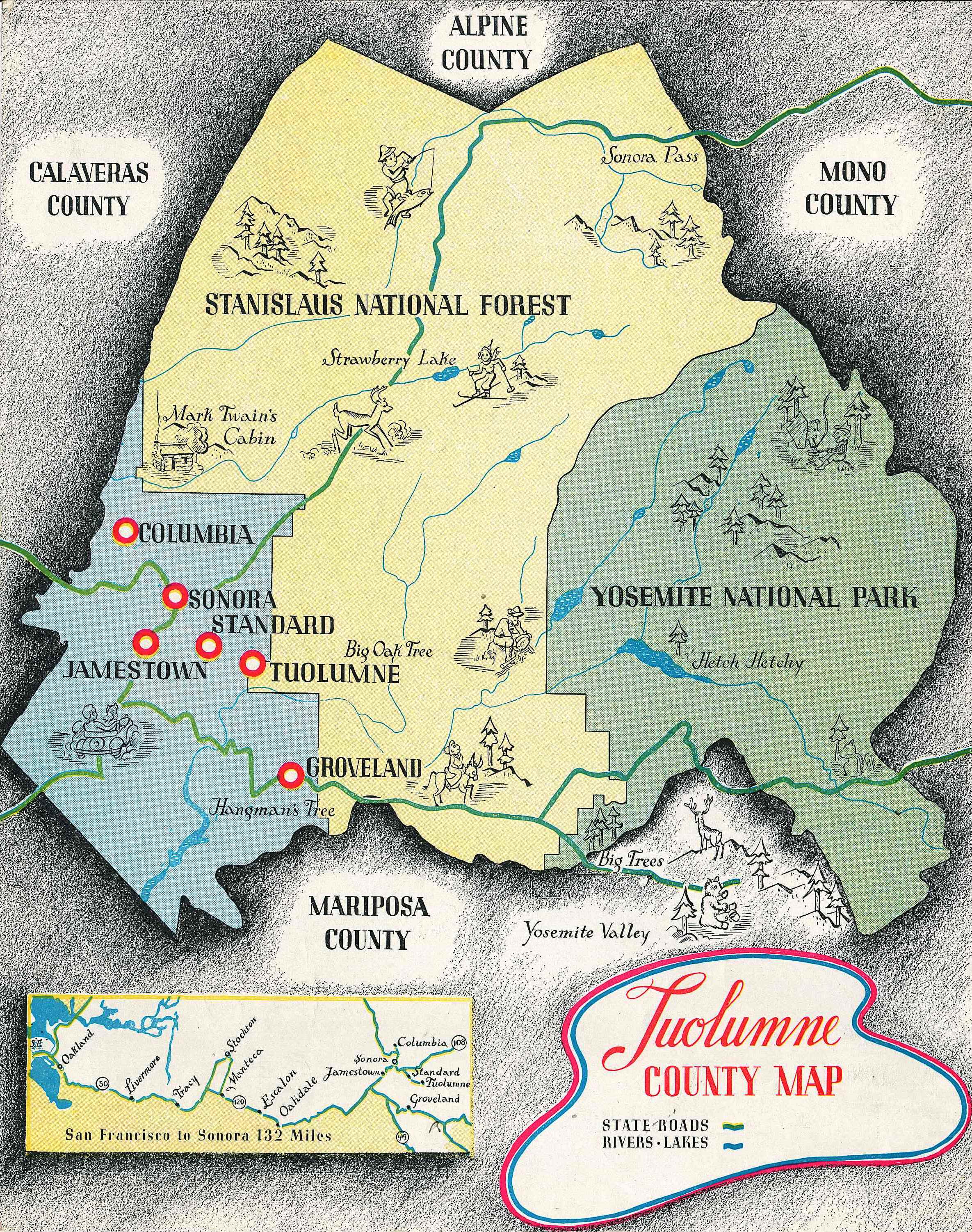
The northern half of Yosemite National Park is located in the eastern part of the county.
Etymology
The name Tuolumne is of Native American origin and has been given different meanings, such as Many Stone Houses, The Land of Mountain Lions, and Straight Up Steep, the latter an interpretation of William Fuller, a native Chief. Mariano Vallejo, in his report to the first California State Legislature, said that the word is "a corruption of the Native American word talmalamne which signifies 'cluster of stone wigwams.'" The name may mean "people who dwell in stone houses," i.e., in caves.
History
**Tuolumne County Boundaries **
One of California's original 27 counties, Tuolumne was organized in 1850.
Prior to the official naming of counties by the state, Tuolumne was sometimes referred to as Oro County.
The original lines of Tuolumne County were not long established. In 1854 and 1855 the portion of Tuolumne County that extended west into the San Joaquin Valley was reorganized as Stanislaus County. In 1864 a number of the original counties including Tuolumne contributed lands that would lead to the establishment of Alpine County to the northeast. With the State's Adoption of the Political Code in 1872 the current boundaries of Tuolumne County were largely established as shown in the maps below.

Geography
According to the U.S. Census Bureau, the county has a total area of 2274 sqmi, of which 2221 sqmi is land and 54 sqmi (2.4%) is water. A California Department of Forestry document reports Tuolumne County's 1030812 acre include federal lands such as Yosemite National Park, Stanislaus National Forest, Bureau of Land Management lands, and Indian reservations. Notable landforms in the county include Table Mountain.
Special Districts
Special districts in Tuolumne County include:
- Belleview Elementary School District
- Big Oak Flat-Groveland Unified School District
- Chinese Camp Elementary School District
- Columbia Fire District
- Columbia Union Elementary School District
- Curtis Creek Elementary School District
- Groveland Community Services District
- Jamestown Elementary School District
- Jamestown Fire District
- Mi-Wuk Sugar Pine Fire Protection District
- Sonora Elementary School District
- Sonora Union High School District
- Soulsbyville Elementary School District
- Strawberry Fire District
- Summerville Elementary School District
- Summerville Union High School District
- Tuolumne County Air Pollution Control District
- Tuolumne County Water District No. 1
- Tuolumne Fire District
- Tuolumne Regional Water District
- Tuolumne Utilities District
- Twain Harte Fire District
- Twain Harte-Long Barn Union Elementary School District
- Yosemite Community College District
Adjacent counties
- Alpine County, California - north
- Calaveras County, California - northwest
- Stanislaus County, California - southwest
- Mariposa County, California - south
- Madera County, California - southeast
- Mono County, California - east
- Merced County, California - southwest
Geographical features
;Environmental
- Red Hills (Tuolumne County) (Area of Critical Environmental Concern)
- Stanislaus National Forest (National protected area, part)
- Yosemite National Park (NPA, part)
;Valleys
- Grand Canyon of the Tuolumne
- Lone Gulch
- Tiltill Valley
Transportation
Major highways
- [[File:California 49.svg|20px]] California State Route 49
- [[File:California 108.svg|20px]] California State Route 108
- [[File:California 120.svg|20px]] California State Route 120
- [[File:California 132.svg|20px]] California State Route 132
Public transportation
Tuolumne County Transit bus routes radiate from Sonora to serve most of the county. In Columbia, a connection can be made to Calaveras County Transit. There is no public transportation into or out of Tuolumne County that connects to any of the closest metropolitan areas.
Yosemite Area Regional Transportation System (YARTS) makes a single daily round trip from Sonora into Yosemite Valley during the summer months.
Airports
Columbia Airport and Pine Mountain Lake Airport are both general aviation airports located in the Southwest and Northeast corners of the county respectively.
Crime
The following table includes the number of incidents reported and the rate per 1,000 persons for each type of offense.
| Population and crime rates | Population | Violent crime | Homicide | Forcible rape | Robbery | Aggravated assault | Property crime | Burglary | Larceny-theftOnly larceny-theft cases involving property over $400 in value are reported as property crimes. | Motor vehicle theft | Arson |
|---|---|---|---|---|---|---|---|---|---|---|---|
| 55,736 | |||||||||||
| 158 | 2.83 | ||||||||||
| 1 | 0.02 | ||||||||||
| 25 | 0.45 | ||||||||||
| 19 | 0.34 | ||||||||||
| 113 | 2.03 | ||||||||||
| 669 | 12.00 | ||||||||||
| 354 | 6.35 | ||||||||||
| 846 | 15.18 | ||||||||||
| 100 | 1.79 | ||||||||||
| 11 | 0.20 |
Cities by population and crime rates
| Cities by population and crime rates | City | Population | Violent crimes | Violent crime rate | ||
|---|---|---|---|---|---|---|
| per 1,000 persons | Property crimes | Property crime rate | ||||
| per 1,000 persons | ||||||
| Sonora | 4,804 | 20 | 4.07 | 311 | 63.33 |
Demographics
1790–1960 1900–1990 1990–2000 2010 2020 | align-fn = center
2020 census
As of the 2020 census, the county had a population of 55,620 and a median age of 48.9 years. 16.8% of residents were under the age of 18 and 27.1% of residents were 65 years of age or older. For every 100 females there were 107.3 males, and for every 100 females age 18 and over there were 108.0 males age 18 and over.
The racial makeup of the county was 79.5% White, 1.8% Black or African American, 1.8% American Indian and Alaska Native, 1.5% Asian, 0.2% Native Hawaiian and Pacific Islander, 5.0% from some other race, and 10.2% from two or more races. Hispanic or Latino residents of any race comprised 12.8% of the population.
52.2% of residents lived in urban areas, while 47.8% lived in rural areas.
There were 22,711 households in the county, of which 22.6% had children under the age of 18 living with them and 26.5% had a female householder with no spouse or partner present. About 30.6% of all households were made up of individuals and 16.9% had someone living alone who was 65 years of age or older.
There were 31,415 housing units, of which 27.7% were vacant. Among occupied housing units, 71.7% were owner-occupied and 28.3% were renter-occupied. The homeowner vacancy rate was 2.0% and the rental vacancy rate was 5.1%.
Racial and ethnic composition
| Race / Ethnicity (NH = Non-Hispanic) | Pop 1980 | Pop 1990 | title=P004: Hispanic or Latino, and Not Hispanic or Latino by Race – 2000: DEC Summary File 1 – Tuolumne County, California | url=https://data.census.gov/table?g=050XX00US06109&tid=DECENNIALSF12000.P004 | website=United States Census Bureau | access-date= }} | title=P2: Hispanic or Latino, and Not Hispanic or Latino by Race – 2010: DEC Redistricting Data (PL 94-171) – Tuolumne County, California | url=https://data.census.gov/cedsci/table?q=p2&g=050XX00US06109&tid=DECENNIALPL2010.P2 | website=United States Census Bureau | access-date= }} | Pop 2020 | % 1980 | % 1990 | % 2000 | % 2010 | % 2020 |
|---|---|---|---|---|---|---|---|---|---|---|---|---|---|---|---|---|
| White alone (NH) | 30,945 | 41,887 | 46,377 | 45,325 | 42,254 | 91.21% | 86.44% | 85.09% | 81.87% | 75.97% | ||||||
| Black or African American alone (NH) | 373 | 1,529 | 1,135 | 1,114 | 989 | 1.10% | 3.16% | 2.08% | 2.01% | 1.78% | ||||||
| Native American or Alaska Native alone (NH) | 599 | 876 | 864 | 830 | 784 | 1.77% | 1.81% | 1.59% | 1.50% | 1.41% | ||||||
| Asian alone (NH) | 189 | 362 | 377 | 530 | 770 | 0.56% | 0.75% | 0.69% | 0.96% | 1.38% | ||||||
| Native Hawaiian or Pacific Islander alone (NH) | x | x | 81 | 62 | 110 | x | x | 0.15% | 0.11% | 0.20% | ||||||
| Other race alone (NH) | 41 | 76 | 47 | 230 | 313 | 0.12% | 0.16% | 0.09% | 0.42% | 0.56% | ||||||
| Mixed race or Multiracial (NH) | x | x | 1,175 | 1,356 | 3,276 | x | x | 2.16% | 2.45% | 5.89% | ||||||
| Hispanic or Latino (any race) | 1,781 | 3,726 | 4,445 | 5,918 | 7,124 | 5.25% | 7.69% | 8.16% | 10.69% | 12.81% | ||||||
| Total | 33,928 | 48,456 | 54,501 | 55,365 | 55,620 | 100.00% | 100.00% | 100.00% | 100.00% | 100.00% |
2010 census
The 2010 United States census reported that Tuolumne County had a population of 55,365. The racial makeup of Tuolumne County was 48,274 (87.2%) White, 1,143 (2.1%) African American, 1,039 (1.9%) Native American, 572 (1.0%) Asian, 76 (0.1%) Pacific Islander, 2,238 (4.0%) from other races, and 2,023 (3.7%) from two or more races. Hispanic or Latino of any race were 5,918 persons (10.7%).
| Population reported at 2010 United States census |
|---|
| The County |
| Tuolumne County |
| **Incorporated |
| cities and towns** |
| Sonora |
| **Census-designated |
| places** |
| Cedar Ridge |
| Chinese Camp |
| Cold Springs |
| Columbia |
| East Sonora |
| Groveland |
| Jamestown |
| Long Barn |
| Mi-Wuk Village |
| Mono Vista |
| Phoenix Lake |
| Pine Mountain Lake |
| Sierra Village |
| Soulsbyville |
| Strawberry |
| Tuolumne City |
| Tuttletown |
| Twain Harte |
| **Other |
| unincorporated areas** |
| All others not CDPs (combined) |
2000 census
As of the census of 2000, there were 54,501 people, 21,004 households, and 14,240 families residing in the county. The population density was 9 /km2. There were 28,336 housing units at an average density of 5 /km2. The racial makeup of the county was 89.5% White, 2.1% Black or African American, 1.8% Native American, 0.7% Asian, 0.2% Pacific Islander, 2.9% from other races, and 2.8% from two or more races. 8.2% of the population were Hispanic or Latino of any race. 94.7% spoke English and 3.5% Spanish as their first language.
There were 21,004 households, out of which 26.1% had children under the age of 18 living with them, 54.4% were married couples living together, 9.6% had a female householder with no husband present, and 32.2% were non-families. 26.0% of all households were made up of individuals, and 11.70% had someone living alone who was 65 years of age or older. The average household size was 2.36 and the average family size was 2.82.
In the county, the population was spread out, with 20.7% under the age of 18, 7.6% from 18 to 24, 25.3% from 25 to 44, 27.9% from 45 to 64, and 18.5% who were 65 years of age or older. The median age was 43 years. For every 100 females there were 111.50 males. For every 100 females age 18 and over, there were 112.20 males.
The median income for a household in the county was $38,725, and the median income for a family was $44,327. Males had a median income of $35,373 versus $25,805 for females. The per capita income for the county was $21,015. About 8.1% of families and 11.4% of the population were below the poverty line, including 16.2% of those under age 18 and 4.0% of those age 65 or over.
Government and policing
The Government of Tuolumne County is established and defined by the California Constitution and is a five-member elected Board Of Supervisors who serve four year elected terms. The government provides services such as elections and voter registration, law enforcement, jails, vital records, property records, tax collection, public health, and social services. The Board is the government for all unincorporated areas. Sonora is the only incorporated city in Tuolumne County.
Sheriff and Police
The Tuolumne County Sheriff provides court protection, jail administration, and coroner services for the entire county. It provides patrol and detective services for the unincorporated areas of the county.
Within the city limits of Sonora, patrol and detective services are served by the Sonora Police Department.
Politics
Voter registration statistics
| Population and registered voters | Total population | Registered votersPercentage of registered voters with respect to total population. Percentages of party members with respect to registered voters follow. | Democratic | Republican | Democratic–Republican spread | Independent | Green | Libertarian | Peace and Freedom | Americans Elect | Other | No party preference |
|---|---|---|---|---|---|---|---|---|---|---|---|---|
| 55,736 | ||||||||||||
| 32,101 | 57.6% | |||||||||||
| 10,306 | 32.1% | |||||||||||
| 13,529 | 42.1% | |||||||||||
| -3,223 | -10.0% | |||||||||||
| 1,313 | 4.1% | |||||||||||
| 248 | 0.8% | |||||||||||
| 248 | 0.8% | |||||||||||
| 100 | 0.3% | |||||||||||
| 1 | 0.0% | |||||||||||
| 68 | 0.2% | |||||||||||
| 6,288 | 19.6% |
Cities by population and voter registration
| Cities by population and voter registration | City | Population | Registered voters | |||||
|---|---|---|---|---|---|---|---|---|
| Democratic | Republican | D–R spread | Other | No party preference | ||||
| Sonora | 4,899 | 55.0% | 38.2% | 32.4% | +5.8% | 10.7% | 22.8% |
Overview
Tuolumne county tends to vote Republican in Presidential and congressional elections. The last Democrat to win the county was Bill Clinton in 1992. In the 2008 presidential election, 14,988 votes were counted for John McCain with former president Barack Obama receiving 11,532 votes.
Tuolumne County is in . In the state legislature Tuolumne is in the 8th Assembly district, which is held by Republican David Tangipa and the 4th Senate district, which is held by Republican Marie Alvarado-Gil.
Communities
City
- Sonora (county seat)
Census-designated places
- Cedar Ridge
- Chinese Camp
- Cold Springs
- Columbia
- East Sonora
- Groveland
- Jamestown
- Long Barn
- Mi-Wuk Village
- Mono Vista
- Phoenix Lake
- Pine Mountain Lake
- Sierra Village
- Soulsbyville
- Strawberry
- Tuolumne
- Tuttletown
- Twain Harte
Unincorporated communities
- Bumblebee
- Confidence
- Dardanelle
- Deadwood
- Mather
- Moccasin
- Pinecrest
- Priest
- Standard
Population ranking
The population ranking of the following table is based on the 2010 census of Tuolumne County.
† county seat
| Rank | City/Town/etc. | Municipal type | Population (2010 Census) |
|---|---|---|---|
| 1 | † Sonora | City | 4,610 |
| 2 | Phoenix Lake | CDP | 4,269 |
| 3 | Jamestown | CDP | 3,433 |
| 4 | Mono Vista | CDP | 3,127 |
| 5 | Pine Mountain Lake | CDP | 2,796 |
| 6 | Columbia | CDP | 2,297 |
| 7 | East Sonora | CDP | 2,266 |
| 8 | Twain Harte | CDP | 2,226 |
| 9 | Soulsbyville | CDP | 2,215 |
| 10 | Tuolumne City | CDP | 1,779 |
| 11 | Cedar Ridge | CDP | 1,132 |
| 12 | Mi-Wuk Village | CDP | 941 |
| 13 | Tuttletown | CDP | 668 |
| 14 | Groveland | CDP | 601 |
| 15 | Sierra Village | CDP | 456 |
| 16 | Tuolumne Rancheria | AIAN | 185 |
| 17 | Cold Springs | CDP | 181 |
| 18 | Long Barn | CDP | 155 |
| 19 | Chinese Camp | CDP | 126 |
| 20 | Strawberry | CDP | 126 |
| 21 | Chicken Ranch Rancheria | AIAN | 91 |
Explanatory notes
References
References
- "State & County QuickFacts".
- "Chronology". California State Association of Counties.
- "Gross Domestic Product: All Industries in Tuolumne County, CA". [[Federal Reserve Bank of St. Louis]].
- "Board of Supervisors | Tuolumne County, CA - Official Website".
- "Tuolumne County". Tuolumne County Government.
- link. (May 14, 2013 , scroll down)
- "Tuolumne County, California".
- "Find a County". National Association of Counties.
- "Chief Fuller Historical Monument".
- (July 2, 2022). "The most mispronounced places in California". KTLA.
- "Tuolumne County, California – International Cities of Peace".
- (February 12, 2011). "US Gazetteer files: 2010, 2000, and 1990". [[United States Census Bureau]].
- {{GNIS. 217919
- U.S. Census Bureau. American Community Survey, 2011 American Community Survey 5-Year Estimates, Table B02001. [https://www.census.gov U.S. Census website]. Retrieved October 26, 2013.
- Office of the Attorney General, Department of Justice, State of California. [http://stats.doj.ca.gov/cjsc_stats/prof09/00/11.pdf Table 11: Crimes – 2009] {{webarchive. link. (December 2, 2013 . Retrieved November 14, 2013.)
- United States Department of Justice, Federal Bureau of Investigation. [https://www.fbi.gov/about-us/cjis/ucr/crime-in-the-u.s/2012/crime-in-the-u.s.-2012/tables/8tabledatadecpdf/table-8-state-cuts/table_8_offenses_known_to_law_enforcement_by_california_by_city_2012.xls Crime in the United States, 2012, Table 8 (California)]. Retrieved November 14, 2013.
- "Annual Estimates of the Resident Population for Counties: April 1, 2020 to July 1, 2024". United States Census Bureau.
- "Census of Population and Housing from 1790-2000". [[US Census Bureau]].
- "Historical Census Browser". University of Virginia Library.
- "Population of Counties by Decennial Census: 1900 to 1990". United States Census Bureau.
- "Census 2000 PHC-T-4. Ranking Tables for Counties: 1990 and 2000". United States Census Bureau.
- (2021). "2020 Decennial Census Demographic Profile (DP1)".
- (2021). "2020 Decennial Census Redistricting Data (Public Law 94-171)".
- (2023). "2020 Decennial Census Demographic and Housing Characteristics (DHC)".
- "P004: Hispanic or Latino, and Not Hispanic or Latino by Race – 2000: DEC Summary File 1 – Tuolumne County, California".
- "P2: Hispanic or Latino, and Not Hispanic or Latino by Race – 2010: DEC Redistricting Data (PL 94-171) – Tuolumne County, California".
- "P2: Hispanic or Latino, and Not Hispanic or Latino by Race – 2020: DEC Redistricting Data (PL 94-171) – Tuolumne County, California".
- included in the Asian category in the 1980 Census
- included in the Asian category in the 1990 Census
- not an option in the 1980 Census
- not an option in the 1990 Census
- {{USCensus2010CA
- "U.S. Census website". [[United States Census Bureau]].
- California Secretary of State. [http://www.sos.ca.gov/elections/ror/ror-pages/ror-odd-year-2013/political-sub.pdf February 10, 2013 - Report of Registration] {{webarchive. link. (July 27, 2013 . Retrieved October 31, 2013.)
- "Local and National Election Results - Election Center 2008 - Elections & Politics from CNN.com".
- Leip, David. "Dave Leip's Atlas of U.S. Presidential Elections".
- {{Cite GovTrack. CA. 4
- "Census Coverage Measurement".
- "2010 Census Interactive Population Search : Tuolumne Rancheria".
- "2010 Census Interactive Population Search : Chicken Ranch Rancheria".
This article was imported from Wikipedia and is available under the Creative Commons Attribution-ShareAlike 4.0 License. Content has been adapted to SurfDoc format. Original contributors can be found on the article history page.
Ask Mako anything about Tuolumne County, California — get instant answers, deeper analysis, and related topics.
Research with MakoFree with your Surf account
Create a free account to save articles, ask Mako questions, and organize your research.
Sign up freeThis content may have been generated or modified by AI. CloudSurf Software LLC is not responsible for the accuracy, completeness, or reliability of AI-generated content. Always verify important information from primary sources.
Report