From Surf Wiki (app.surf) — the open knowledge base
Tullaghan
Village in County Leitrim, Ireland

Village in County Leitrim, Ireland
| Field | Value |
|---|---|
| name | Tullaghan |
| native_name | ga |
| native_name_lang | gle |
| settlement_type | Village |
| image_skyline | Leitrimtullaghan.JPG |
| image_caption | Tullaghan village |
| pushpin_map | Ireland |
| pushpin_label_position | left |
| pushpin_map_caption | Location in Ireland |
| subdivision_type | Country |
| subdivision_name | Ireland |
| subdivision_type1 | Province |
| subdivision_name1 | Connacht |
| subdivision_type3 | County |
| subdivision_name3 | County Leitrim |
| unit_pref | Metric |
| area_footnotes | |
| area_total_km2 | 0.53 |
| population_as_of | 2016 |
| population_footnotes | |
| population_total | 253 |
| population_density_km2 | auto |
| timezone1 | WET |
| utc_offset1 | +0 |
| timezone1_DST | IST (WEST) |
| utc_offset1_DST | -1 |
| coordinates | |
| blank_name | Irish Grid Reference |
| blank_info |
Tullaghan () is the most northerly village in County Leitrim, Ireland. Lying at the northern end of Glenade, Tullaghan is in the parish of Kinlough and Glenade and is part of the Manorhamilton electoral area.
Geography
Tullaghan is located on the N15 road between Sligo (35 km) and Bundoran, County Donegal (3 km). Tullaghan includes a small section of County Sligo and extends east to the edge of Lough Melvin and the Garrison lowlands, west to Bunduff strand (in the north Sligo coastal area) and south to the northern slopes of the Dartry Mountains and the Arroo and Mountain Outliers. The River Drowes denotes the border between County Leitrim and County Donegal and the River Duff forms the border between County Leitrim and County Sligo. The R280 road connects Tullaghan with the rest of County Leitrim. Tullaghan has the single shortest bit of county coastline in Ireland – a mere 4.7 kilometres (2.9 mi) long.
History
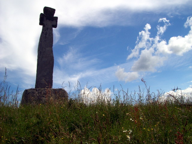
Tullaghan has a high cross located on the roadside of the N15, being erected in its current location in 1778. St Patricks Well is located approximately 3 km west from the village on the coast road past St Patricks church. Back in 1925, Tullaghan village comprised 19 houses, 5 being licensed to sell alcohol.{{cite report |access-date=21 May 2017 |archive-date=15 December 2018 |archive-url=https://web.archive.org/web/20181215070011/https://dspace.gipe.ac.in/xmlui/handle/10973/25609 |url-status=live
Religion
Saint Patrick's Catholic Church was built in 1842.
References
References
- "Tullaghan Map, Leitrim".
- (April 2016). "Census 2016 Sapmap Area: Settlements Tullaghan". [[Central Statistics Office (Ireland)]].
- "An Tulachán/Tullaghan". [[Department of Arts, Heritage and the Gaeltacht.
- "Tullaghan".
- "Counties of Ireland - Leitrim".
- "Places to go".
- "Tullaghan Cross".
- (16 October 2010). "Tullaghan Hill Holy Well {{!}} Voices from the Dawn".
This article was imported from Wikipedia and is available under the Creative Commons Attribution-ShareAlike 4.0 License. Content has been adapted to SurfDoc format. Original contributors can be found on the article history page.
Ask Mako anything about Tullaghan — get instant answers, deeper analysis, and related topics.
Research with MakoFree with your Surf account
Create a free account to save articles, ask Mako questions, and organize your research.
Sign up freeThis content may have been generated or modified by AI. CloudSurf Software LLC is not responsible for the accuracy, completeness, or reliability of AI-generated content. Always verify important information from primary sources.
Report