From Surf Wiki (app.surf) — the open knowledge base
Truckee River
River in Nevada and California, United States

River in Nevada and California, United States
| Field | Value |
|---|---|
| name | Truckee River |
| name_native | {{native name list |
| tag1 | pao |
| name1 | Kuyuinahukwa |
| italics1 | no |
| paren1 | yes |
| tag2 | was |
| name2 | ‘Át’abi wá’t’a |
| italics2 | no |
| paren2 | yes |
| tag3 | was |
| name3 | Wá’tia t’íyel |
| italics3 | no |
| paren3 | yes |
| tag4 | was |
| name4 | Á’waku wá’t’a (at Pyramid Lake) |
| italics4 | no |
| paren4 | yes |
| tag5 | was |
| name5 | Debeyúmewe (at Lake Tahoe) |
| italics5 | no |
| paren5 | yes |
| tag6 | was |
| name6 | Balņatsoņ w’áta |
| italics6 | no |
| paren6 | yes |
| name_other | {{native name list |
| tag1 | pao |
| name1 | Kuyuinahukwa |
| italics1 | no |
| paren1 | yes |
| tag2 | was |
| name2 | ‘Át’abi wá’t’a |
| italics2 | no |
| paren2 | yes |
| tag3 | was |
| name3 | Wá’tia t’íyel |
| italics3 | no |
| paren3 | yes |
| tag4 | was |
| name4 | Á’waku wá’t’a |
| italics4 | no |
| paren4 | yes |
| tag5 | was |
| name5 | Balņatsoņ w’áta |
| italics5 | no |
| paren5 | yes |
| Salmon Trout River<ref name | Fremont |
| name_etymology | Named after the Paiute chief Truckee |
| image | Truckee river.JPG |
| image_size | 300 |
| image_caption | The Truckee River just east of Truckee, California |
| map | Truckeerivermap.png |
| map_size | 300 |
| map_caption | Map of the Pyramid Lake drainage basin |
| pushpin_map_size | 300 |
| subdivision_type1 | Country |
| subdivision_name1 | United States |
| subdivision_type2 | State |
| subdivision_name2 | California, Nevada |
| length | 121 mi |
| discharge1_location | USGS gage 10350000, Truckee River at Vista, NV |
| discharge1_min | 7 cuft/s |
| discharge1_avg | 804 cuft/s |
| discharge1_max | 17400 cuft/s |
| source1 | Lake Tahoe |
| source1_location | Sierra Nevada, California |
| source1_coordinates | |
| source1_elevation | 6233 ft |
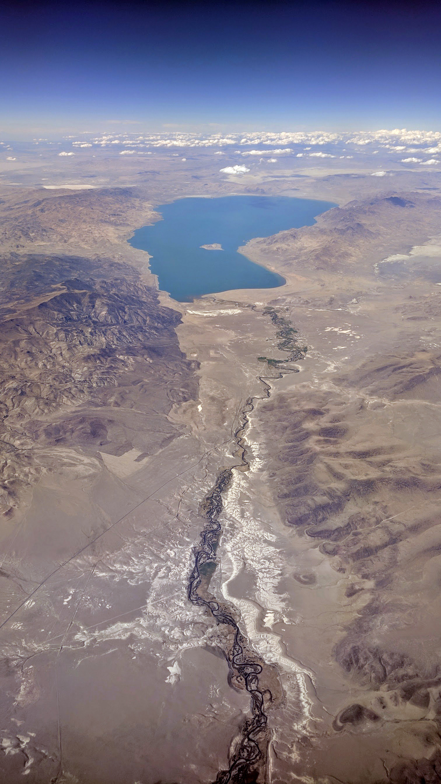
| mouth | Pyramid Lake |
| mouth_location | Nevada |
| mouth_coordinates | |
| mouth_elevation | 3793 ft |
| basin_size | 3060 sqmi |
the river that flows from Lake Tahoe through Truckee and Reno into Pyramid Lake
Salmon Trout River
The Truckee River is a river in the U.S. states of California and Nevada. The river flows northeasterly and is 121 mi long. The Truckee is the sole outlet of Lake Tahoe and drains part of the high Sierra Nevada, emptying into Pyramid Lake in the Great Basin. Its waters are an important source of irrigation along its valley and adjacent valleys.
Naming of the river
A Northern Paiute word for the Truckee is Kuyuinahukwa. Kuyui- refers to the Cui-ui, a species of fish endemic to Pyramid Lake which is central to the lives of the Northern Paiute band called the Kuyui Dükadü (cui-ui-fish-eaters).
In the Washo language, different parts of the river have different names. Two names, ‘Át’abi wá’t’a and Á’waku wá’t’a translate to "trout stream." The latter name refers to the river at and around Pyramid Lake. At the outlet at Lake Tahoe, there are multiple names as well. Dawbayódok is said to refer to the area when one is situated "on the down side" of the outlet, while Dawbayóduwé is used when one is "on the up side." Debeyúmewe, translated as "coming out," is less specific.
When John C. Frémont and Kit Carson ascended the Truckee River on January 16, 1844, they called it the Salmon Trout River, after the huge Lahontan cutthroat trout (Oncorhynchus clarki henshawi) that ran up the river from Pyramid Lake to spawn. However, the river was ultimately named after a Paiute chief known as Truckee, who in 1844 guided an emigrant party from the headwaters of the Humboldt River to California via the Truckee River, Donner Lake, and Donner Pass. Appreciative of their Native American guide's services, the party named the river after him. The chief's real name might not have been Truckee, but perhaps Tru-ki-zo, which could have become distorted as "Truckee". There are numerous other theories about Chief Truckee and his name.
Course and watershed


The Truckee River's source is the outlet of Lake Tahoe, at the dam on the northwest side of the lake near Tahoe City, California. It flows generally northeast through the mountains to Truckee, California, then turns sharply to the east and flows into Nevada, through Reno and Sparks and along the northern end of the Carson Range. At Fernley it turns north, flowing along the east side of the Pah Rah Range. It empties into the southern end of Pyramid Lake, a remnant of prehistoric Lake Lahontan, in northern Washoe County in the Pyramid Lake Indian Reservation.
The Truckee River's endorheic drainage basin is about 3060 sqmi, of which about 2300 sqmi are in Nevada. The Middle Watershed is regarded as the 15 mi of river and its tributaries from Tahoe City in Placer County, through the Town of Truckee in Nevada County, to the state line between Sierra and Washoe counties. The major tributaries to the Truckee River in California from the Lake Tahoe outlet and heading downstream include: Bear Creek, Washeshu Creek, Cabin Creek, Pole Creek, Donner Creek, Trout Creek, Martis Creek, Prosser Creek, the Little Truckee River, Gray Creek, and Bronco Creek. Major lakes and reservoirs in the California part of the watershed include Lake Tahoe, Donner Lake, Independence Lake (California), Webber Lake, Boca Reservoir, Stampede Reservoir, Prosser Creek Reservoir, and Martis Creek Reservoir. In the Lower Watershed, Steamboat Creek, which drains Washoe Lake, is the major tributary to the Truckee River. The Steamboat Ditch, a 34 mi irrigation canal constructed in 1880, diverts water from the Truckee near the California-Nevada border and terminates at Steamboat Creek in south Reno.
River modifications

Like many other rivers in the western United States, the Truckee's flow is highly regulated, with most river flow fully allocated through a system of water rights, set in 2015 by the Truckee River Operating Agreement. This system over-allocates available water during low flow periods. Disputes occur among those asserting rights to the water. In the early 20th century, the Newlands Reclamation Act instituted a diversion that removed river flows from the Truckee River watershed and transferred them to the Carson River watershed. Currently the Truckee–Carson Irrigation District supervises the diversion of approximately one-third of the river flow at the Derby Dam to the Lahontan Valley to irrigate alfalfa and pastures. Truckee River water is also supplied to the resort communities surrounding Lake Tahoe, the greater metropolitan area of Reno and Sparks, and the Pyramid Lake Paiute Indian Reservation. The U.S. Fish and Wildlife Service uses some of the water to induce spawning of the endangered fish cui-ui and to provide drought relief.
Ecology
Beavers were re-introduced to the Truckee River watershed and Tahoe Basin by the California Department of Fish and Game (CDFG) and the U. S. Forest Service between 1934 and 1949 in order to prevent stream degradation and to promote wetland restoration. That beaver were once native to the area is supported by the fact that the Washo have a word for beaver, c'imhélhel{{Cite web | access-date = 2012-07-07
Recreation


The river is heavily used for recreation, including whitewater rafting and fly fishing. A common rafting run is the River Ranch Run. Starting from the outlet gates at Lake Tahoe stretching about 3 mi, the run ends at the River Ranch Restaurant. These rapids are almost all class 1 and class 2. In downtown Reno the river has been sculpted into a half-mile Class 2/3 whitewater park, and is used mainly for kayaking.
The Truckee River is western Nevada's largest river. It supports a large sport fishing population each year. Kim Tisdale of the Nevada Department of Wildlife (NDOW), is the state's Western Regions Fishery Supervisor; she commented that NDOW's goal is for a catch rate of one to two fish per hour in the Truckee. To accomplish this, NDOW stocks a total of 105,000 trout per year. 70,000 of those are native Lahontan cutthroat trout (Oncorhynchus clarki henshawi) and the rest are non-native Rainbow trout (Oncorhynchus mykiss). The Truckee also boasts a healthy, self-sustaining non-native Brown trout (Salmo trutta) population.
Hydrology and water quality
Because of the endangered species present and because the Lake Tahoe Basin comprises the headwaters of the Truckee River, the river has been the focus of several water quality investigations, the most detailed starting in the mid-1980s. Under the direction of the U.S. Environmental Protection Agency, a comprehensive dynamic hydrology transport model was developed by Earth Metrics Inc. The model's name was subsequently changed to DSSAM, and it was applied to analyze land use, and wastewater management decisions throughout the Truckee River Basin of 3120 sqmi and to provide guidance in other U.S. river basins. Analytes addressed included nitrogen, reactive phosphate, dissolved oxygen, total dissolved solids and nine other parameters. Based on the use of the model, some decisions have been influenced to enhance riverine quality and aid the viability of associated biota. Impacts upon the receiving waters of Pyramid Lake were also analyzed. It is thought that dumping raw sewage into the Truckee River is a detriment to the water quality in several communities.
References
References
- John Charles Fremont. (1847). "Narrative of the exploring expedition to the Rocky mountains: in the year 1842, and to Oregon and north California in the years 1843–44". Hall & Dickson.
- "Water resources data for the United States, Water Year 2009; gage 10350000, Truckee River at Vista, NV". [[USGS]].
- {{GNIS. 861787. Truckee River
- U.S. Geological Survey. National Hydrography Dataset high-resolution flowline data. [http://viewer.nationalmap.gov/viewer/ The National Map], accessed October 20, 2012
- (August 2009). "Assessing the Impacts of Nutrient Load Uncertainties on Predicted Truckee River Water Quality". Journal of Environmental Engineering.
- Ginny Bengston (2002). ''Northern Paiute and Western Shoshone Land Use in Northern Nevada: A Class I Ethnographic/Ethnohistoric Overview'' (PDF). SWCA Environmental Consultants. pp. 6, 50. Retrieved 2022-12-30.
- Natalie E. Davenport. (2019). "Naming, Remembering, and Experiencing We' lmelt' iʔ [northern Washoe] Cultural Spaces in Wa she shu It Deh [Washoe Land]". ScholarWorks, University of Nevada, Reno.
- Natalie E. Davenport. (2019). "Naming, Remembering, and Experiencing We' lmelt' iʔ [northern Washoe] Cultural Spaces in Wa she shu It Deh [Washoe Land]". ScholarWorks, University of Nevada, Reno.
- Natalie E. Davenport. (2019). "Naming, Remembering, and Experiencing We' lmelt' iʔ [northern Washoe] Cultural Spaces in Wa she shu It Deh [Washoe Land]". ScholarWorks, University of Nevada, Reno.
- "Truckee River Chronology". State of Nevada Division of Water Resources.
- [http://truckeehistory.org/historyArticles/history4.htm Chief Truckee] {{Webarchive. link. (2012-10-28 , Truckee–Donner Historical Society)
- [[USGS]] [[topographic map]]s
- Rigby, Jim G.. (1998). "The 1997 New Year's Floods in Western Nevada". Nevada Bureau of Mines and Geology.
- (July 2001). "Water Quality Assessment and Modeling of the California Portion of the Truckee River Basin McGraw 2001". Lahontan Regional Water Quality Control Board.
- "Welcome to the TROA – Truckee River Operating Agreement". www.troa.net.
- A. L. Kroeber. (1919). "Handbook of Indians of California".
- (Summer–Autumn 1970). "Stephen Powers' "The Life and Culture of the Washo and Paiutes"". Ethnohistory.
- Jesse D. Mason. (1881). "History of Amador County". Thompson & West.
- Tappe, Donald T.. (1942). "The Status of Beavers in California". California Department of Fish & Game.
- Theodore Henry Hittell. (1861). "The adventures of James Capen Adams: mountaineer and grizzly bear hunter, of California". Crosby, Nichols, Lee and company.
- (Spring 2012). "Novel physical evidence that beaver historically were native to the Sierra Nevada". California Fish and Game.
- Gard R. (1961). "Effects of beaver on trout in Sagehen Creek, California". Journal of Wildlife Management.
- Michael Benson Ayers. (October 1997). "Aerial Multispectral Videography for Vegetation Mapping and Assessment of Beaver Distribution within Selected Riparian Areas of the Lake Tahoe Basin". University of Nevada at Reno.
- Sarah Muskopf. (October 2007). "The Effect of Beaver (Castor canadensis) Dam Removal on Total Phosphorus Concentration in Taylor Creek and Wetland, South Lake Tahoe, California". Humboldt State University, Natural Resources.
- "Whitewater Park". City of Reno.
- Tisdale, Kim. Telephone Interview. 29 June 2012
- C. Michael Hogan. Marc Papineau et al., ''Development of a dynamic water quality simulation model for the Truckee River'', Earth Metrics Inc., [[United States Environmental Protection Agency. Environmental Protection Agency]] Technology Series, Washington D.C. (1987)
- USEPA. 1991. Guidance for water quality-based decisions: The TMDL process. EPA 440/4-91-001. U.S. Environmental Protection Agency, Office of Water, Washington, DC.
This article was imported from Wikipedia and is available under the Creative Commons Attribution-ShareAlike 4.0 License. Content has been adapted to SurfDoc format. Original contributors can be found on the article history page.
Ask Mako anything about Truckee River — get instant answers, deeper analysis, and related topics.
Research with MakoFree with your Surf account
Create a free account to save articles, ask Mako questions, and organize your research.
Sign up freeThis content may have been generated or modified by AI. CloudSurf Software LLC is not responsible for the accuracy, completeness, or reliability of AI-generated content. Always verify important information from primary sources.
Report