From Surf Wiki (app.surf) — the open knowledge base
Toyama Prefecture
Prefecture of Japan

Prefecture of Japan
| Field | Value | |
|---|---|---|
| <!-- See Template:Infobox settlement for additional fields and descriptions --> | name | Toyama Prefecture |
| native_name | 富山県 | |
| settlement_type | Prefecture | |
| image_skyline | {{multiple image | |
| total_width | 300 | |
| caption_align | center | |
| border | infobox | |
| perrow | 1/2/2/2 | |
| image1 | Tateyama Mountains and Onna-iwa viewed from Amaharashi Coast 20190309134344.jpg | |
| caption1 | Tateyama Mountain Range and Toyama Bay | |
| image2 | 立山雪の大谷20220507-IMG 2206.jpg | |
| caption2 | Snow wall in Tateyama Kurobe Alpine Route | |
| image3 | 相倉合掌造り集落20221105-IMG 4698.jpg | |
| caption3 | Gokayama | |
| image4 | チューリップフェア.jpg | |
| caption4 | Tonami Tulip Fair | |
| image5 | 黒部ダム03.jpg | |
| caption5 | Kurobe Dam | |
| image6 | Owara Kaze no Bon. Midnight event on September 3, 2017. At Kamishin-Machi street.A.jpg | |
| caption6 | Bon Dance of Owara's Wind | |
| image7 | Uozu mirage winter 1.jpg | |
| caption7 | Winter mirage in Toyama Bay and Tateyama Mountain Range | |
| translit_lang1 | Japanese | |
| translit_lang1_type | Japanese | |
| translit_lang1_info | 富山県 | |
| translit_lang1_type1 | Rōmaji | |
| translit_lang1_info1 | Toyama-ken | |
| image_flag | Flag of Toyama.svg | |
| flag_size | 100px | |
| image_blank_emblem | Emblem of Toyama Prefecture.svg | |
| blank_emblem_size | 75px | |
| blank_emblem_type | Emblem | |
| image_map | Map of Japan with highlight on 16 Toyama prefecture.svg | |
| coordinates | ||
| subdivision_type | Country | |
| subdivision_name | Japan | |
| subdivision_type1 | Region | |
| subdivision_name1 | Chūbu (Hokuriku) | |
| subdivision_type2 | Island | |
| subdivision_name2 | Honshu | |
| seat_type | Capital | |
| seat | Toyama | |
| parts_type | Subdivisions | |
| parts_style | para | |
| p1 | Districts: 2 | |
| p2 | Municipalities: 15 | |
| leader_title | Governor | |
| leader_name | Hachiro Nitta | |
| area_total_km2 | 4247.61 | |
| area_water_percent | 0.1 | |
| area_rank | 33rd | |
| population_total | 1044588 | |
| population_as_of | June 1, 2019 | |
| population_rank | 37th | |
| population_density_km2 | auto | |
| demographics_type2 | GDP | |
| demographics2_footnotes | ||
| demographics2_title1 | Total | |
| demographics2_info1 | JP¥ 4,910 billion | |
| US$ 45.0 billion (2019) | ||
| iso_code | JP-16 | |
| website | pref.toyama.jp | |
| module | {{Infobox place symbols | |
| embedded | yes | |
| country | Japan | |
| bird | Ptarmigan | |
| fish | Japanese amberjack | |
| Pasiphaea japonica | ||
| Firefly squid | ||
| flower | Tulip (Tulipa) | |
| tree | Tateyama Cedar (Cryptomeria japonica) | |
| anthem | Toyama kenmin no uta |
US$ 45.0 billion (2019) Pasiphaea japonica Firefly squid
Toyama Prefecture is a prefecture of Japan located in the Chūbu region of Honshu. Toyama Prefecture has a population of 993,848 (1 January 2025) and has a geographic area of 4,247.61 km2 (1,640.01 sq mi). Toyama Prefecture borders Ishikawa Prefecture to the west, Gifu Prefecture to the south, Nagano Prefecture to the east, and Niigata Prefecture to the northeast.
Toyama is the capital and largest city of Toyama Prefecture, with other major cities including Takaoka, Imizu, and Nanto. Toyama Prefecture is part of the historic Hokuriku region, and the majority of the prefecture's population lives on Toyama Bay, one of the largest bays in Japan. Toyama Prefecture is the leading industrial prefecture on the Japan Sea coast and has the advantage of cheap electricity from abundant hydroelectric resources. Toyama Prefecture contains the only known glaciers in East Asia outside of Russia, first recognized in 2012, and 30% of the prefecture's area is designated as national parks.
History
Historically, Toyama Prefecture was Etchū Province. Following the abolition of the han system in 1871, Etchū Province was renamed Niikawa Prefecture, but Imizu District was given to Nanao Prefecture. In 1872 Imizu District was returned by the new Ishikawa Prefecture.
In 1876, Niikawa Prefecture was merged into Ishikawa Prefecture but the merger was void in 1881 and the area was re-established as Toyama Prefecture.
The Itai-itai disease occurred in Toyama around 1950.
Geography
Toyama Prefecture is bordered by Ishikawa Prefecture to the west, Niigata to the northeast, Nagano to the southeast, Gifu to the south and Sea of Japan to the north.
As of April 1, 2012, 30% of the total land area of the prefecture was designated as Natural Parks, namely the Chūbu-Sangaku and Hakusan National Parks; Noto Hantō Quasi-National Park; and six Prefectural Natural Parks.
Municipalities
Due to the mergers in the 2000s, Toyama has the fewest municipalities of any prefecture in Japan with 10 cities, 2 districts, 4 towns, and 1 village (before the mergers took place, the prefecture had 9 cities, 18 towns, and 8 villages).
Mergers
Main article: List of mergers in Toyama Prefecture
List of governors of Toyama Prefecture (1947–present)
- Tetsuji Tachi (館 哲二) (19 April 1947 to 15 November 1947)
- Takekuni Takatsuji (高辻 武邦) (16 November 1947 to 30 September 1956)
- Minoru Yoshida (吉田 実) (1 October 1956 to 1 December 1969)
- Kōkichi Nakata (中田 幸吉) (30 December 1969 to 18 September 1980)
- Yutaka Nakaoki (中沖 豊) (11 November 1980 to 8 November 2004)
- Takakazu Ishii (石井 隆一) (9 November 2004 to 8 November 2020)
- Hachirō Nitta (新田 八朗) (9 November 2020 to present)
Economy
Agriculture
In 2014 Toyama contributed approximately 2.5% of Japan's rice production and makes use of abundant water sources originating from Mount Tate. It also has many fisheries along its Sea of Japan coastline.
Manufacturing
Toyama is famous for its historical pharmaceutical industry which remains a top manufacturing industry in the prefecture in terms of manufacturing shipment value followed by electronic parts and devices (industrial robots, general machinery, etc.), and metal products (aluminum, copper etc.) manufacturing.
Energy
.jpg)
Kurobe Dam generates electricity for the Kansai Electric Power Company. It is located on the Kurobe River in Toyama Prefecture.
Demographics

Per Japanese census data, the population of Toyama has been relatively stable since 1950.
| 1920 |724,276| 1930 |778,953| 1940 |822,569| 1950 |1,008,790| 1960 |1,032,614| 1970 |1,029,695| 1980 |1,103,459| 1990 |1,120,161| 2000 | 1,120,851 | 2010 | 1,093,247 | 2020 |1,034,814|align = none
Transportation
Rail
- JR West
- Hokuriku Shinkansen (Tokyo to Tsuruga via Kurobe, Toyama City and Takaoka)
- Takayama Main Line (Inotani to Toyama City)
- Himi Line
- Jōhana Line
- JR Central
- Takayama Main Line (Gifu to Inotani)
- Ainokaze Toyama Railway (Kurikara, Ishikawa to Ichiburi, Niigata via Takaoka and Toyama City)
- Manyōsen (Third-sector tram system in Takaoka)
- Shinminatokō Line
- Takaoka Kidō Line
- Toyama Chihō Railway
- Main Line
- Tateyama Line
- Fujikoshi Line
- Kamidaki Line
- Toyama City Tram
Expressway
- Hokuriku Expressway
- Nōetsu Expressway
- Tōkai-Hokuriku Expressway
Air
- Toyama Airport (TOY)
Domestic
- Tokyo: 1 hr
- Sapporo: 1 hr 20 min
International
- Dalian: 2 hr 30 min via China Southern Airlines
- Shanghai: 2 hr 30 min via Shanghai Airlines
Culture
Tourist sites
- Tateyama Kurobe Alpine Route
- Kurobe Gorge Railway
- Unazuki Onsen
- Gokayama (UNESCO World Heritage Site)
- Mitsui Outlet Park, Hokuriku Oyabe
UNESCO World Heritage Cultural Sites
- Gokayama Historical Village (Nanto City)
National Treasures of Japan
- Zuiryū-ji Temple (Takaoka City)
Festivals
Spring
- All Japan Chindon Competition (Toyama City (Toyama Castle Park), Mid April
- Tonami Tulip Fair (Tonami City), May
- Marumage Festival (Himi City), May 17
Summer
- Sassa Narimasa Sengoku Era Festival (Toyama City), Late July
- Japan Wildlife Film Festival (Toyama Prefecture), Early August
Fall
- Toyama Festival (Toyama City), Sept. 1
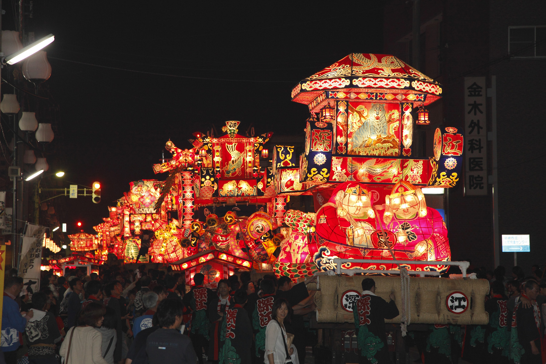
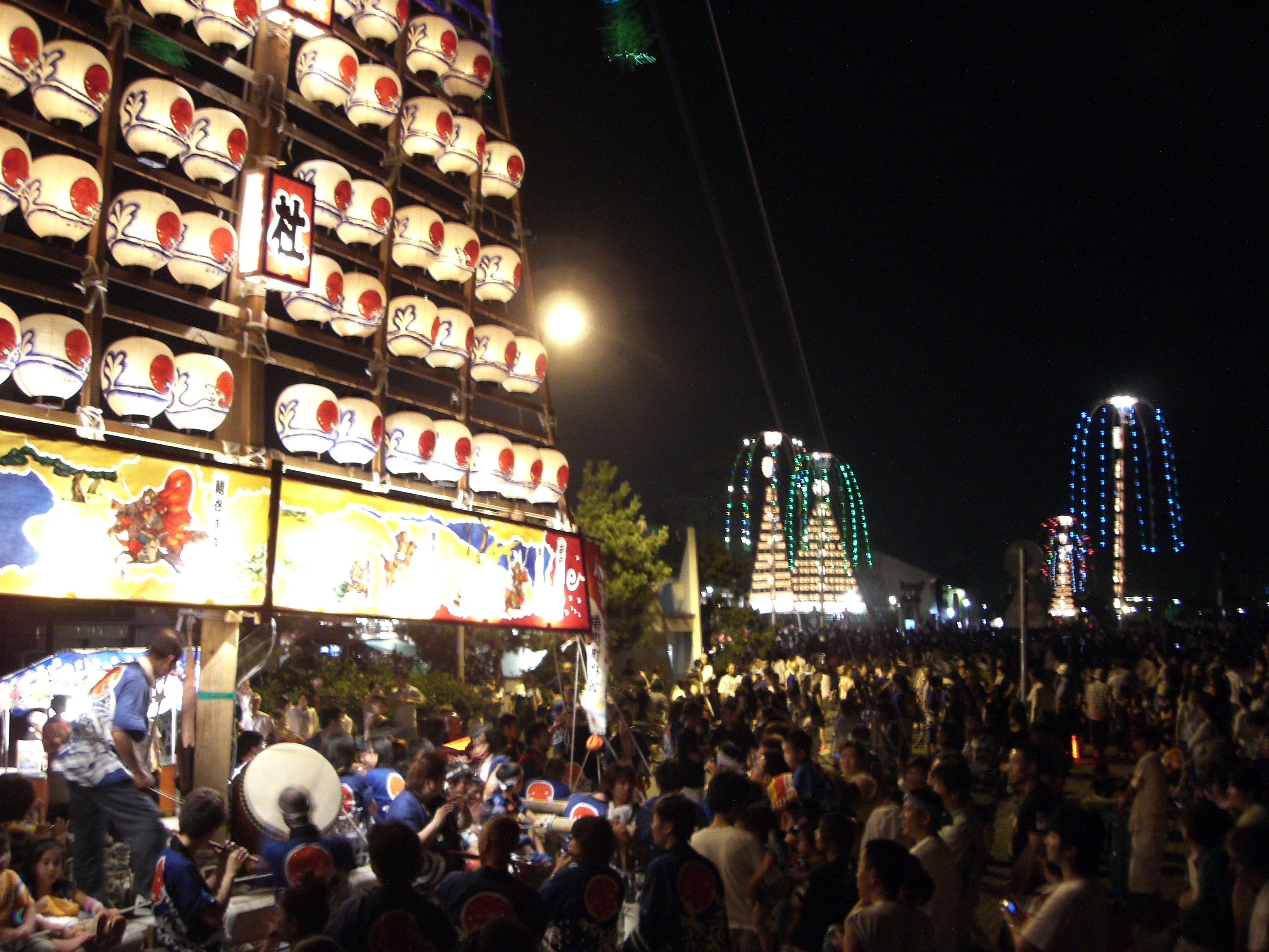
- Owara Kaze no Bon (Toyama City (Yatsuo Area)), Sept. 1–3
Winter
- Nanto Toga Soba Festival (Nanto City (Toga Village Area)), Mid Feb.
Regional foods
- Trout Sushi (Masuzushi)
- White Shrimp (Shiro Ebi)
- Matured Yellow Tail (Buri)
- Firefly Squid (Hotaru Ika)
- Fish Paste (Kamaboko)
Regional sake
- Tateyama (立山)
- Narimasa (成政)
- Masuizumi (満寿泉)
- Sanshoraku (三笑楽)
Sports
The sports teams listed below are based in Toyama.
Football
- Kataller Toyama (Toyama City)
Basketball
- Toyama Grouses (Toyama City)
Baseball
- Toyama Thunderbirds (Toyama City)
Rugby Union
- Takaoka Mariners (Takaoka)
International relations
- CHN Liaoning Province, since May 9, 1984
- BRA São Paulo State, since July 18, 1985
- USA Oregon State, since October 19, 1991
- RUS Primorsky Region, since August 26, 1992
- SUI Basel-Stadt, since October 26, 2009
- IND Andhra Pradesh State, since December 29, 2015
Notes
References
- Nussbaum, Louis-Frédéric and Käthe Roth. (2005). Japan encyclopedia. Cambridge: Harvard University Press. ; OCLC 58053128
- Prefecture, N. (2022). Toyama Prefecture- The East Asia Local and Regional Government Congress. Retrieved 1 July 2022, from https://www3.pref.nara.jp/eastasia_e/1080.html
- McClean, C. (2022). 10 Fun Facts About Toyama Prefecture, Japan - Multicultural Kid Blogs. Retrieved 1 July 2022, from https://multiculturalkidblogs.com/2021/11/15/toyama-prefecture/
References
- "2020年度国民経済計算(2015年基準・2008SNA) : 経済社会総合研究所 - 内閣府".
- link. Toyama Prefectural website. Toyama Prefecture
- NHK Publishing. (24 May 2016)
- Nussbaum, Louis-Frédéric. (2005). "Toyama prefecture" in {{Google books. p2QnPijAEmEC. ''Japan Encyclopedia'', p. 991. p2QnPijAEmEC. p. 344
- Nussbaum, "Toyama" at {{Google books. p2QnPijAEmEC. p. 991
- Matsutani, Minoru. (April 6, 2012). "First glaciers in Japan recognised". The Japan Times.
- Nussbaum, "Provinces and prefectures" at {{Google books. p2QnPijAEmEC. p. 780
- "General overview of area figures for Natural Parks by prefecture". [[Ministry of the Environment (Japan).
- "米の生産 〔2014年〕".
- "Statistics Bureau Home Page".
- "Toyama Prefecture". Canton Basel-Stadt.
- (December 29, 2015). "Andhra Pradesh inks pact with Toyama Prefecture". The Hindu.
This article was imported from Wikipedia and is available under the Creative Commons Attribution-ShareAlike 4.0 License. Content has been adapted to SurfDoc format. Original contributors can be found on the article history page.
Ask Mako anything about Toyama Prefecture — get instant answers, deeper analysis, and related topics.
Research with MakoFree with your Surf account
Create a free account to save articles, ask Mako questions, and organize your research.
Sign up freeThis content may have been generated or modified by AI. CloudSurf Software LLC is not responsible for the accuracy, completeness, or reliability of AI-generated content. Always verify important information from primary sources.
Report