From Surf Wiki (app.surf) — the open knowledge base
Tomb of Samuel
Tomb of biblical figure in Palestine
Tomb of biblical figure in Palestine
| Field | Value |
|---|---|
| name | Tomb of Samuel |
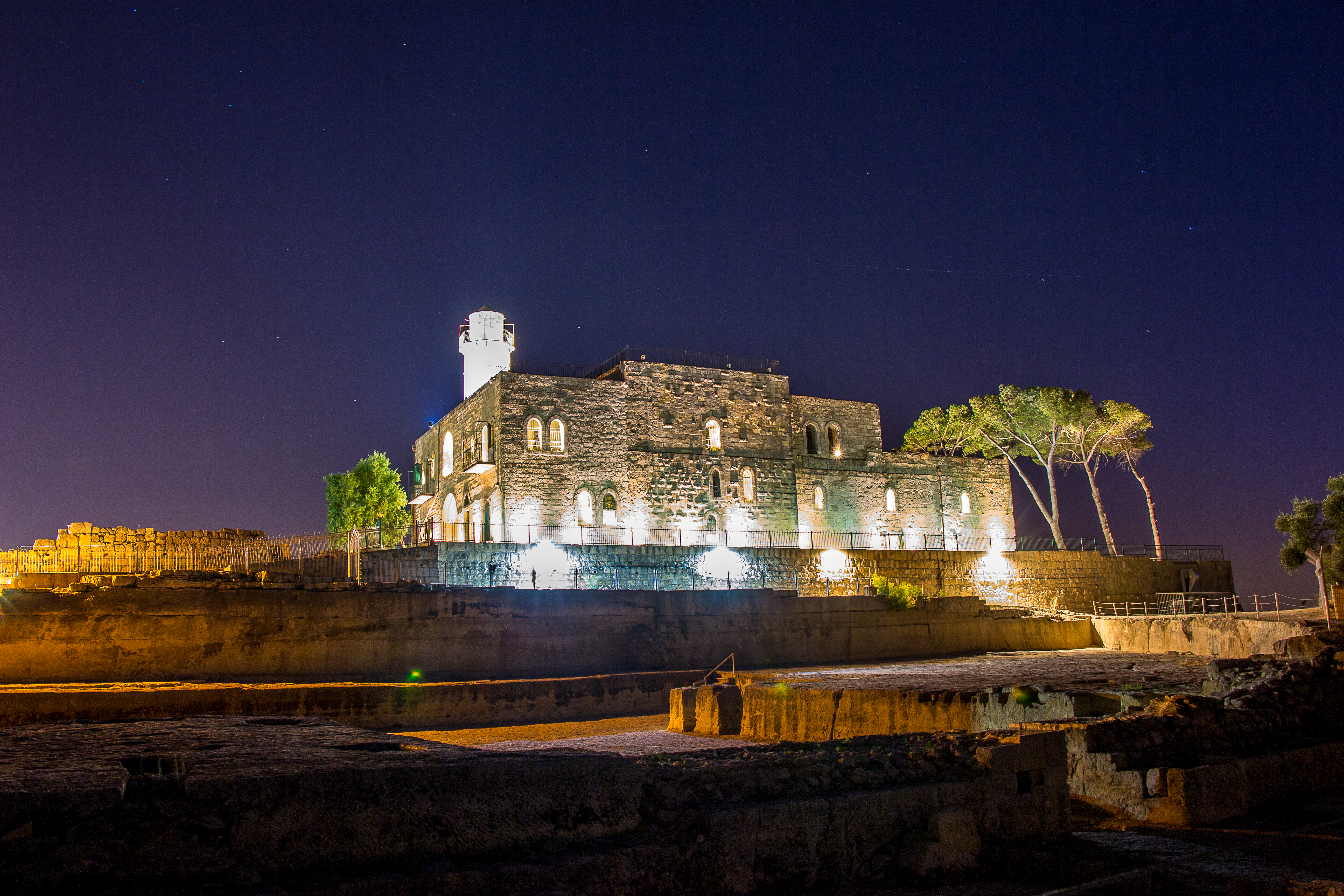
| image | NebiSamuel2.jpg |
| caption | Nabi Samwil mosque built on remains of Crusader-era fortress; the Tomb of Samuel is in a crypt below the Mamluk building. |
| map_type | Palestine |
| map_size | 220 |
| coordinates |
For the Palestinian village in which the tomb is located, see Nabi Samwil
The Tomb of Samuel (, translit. an-Nabi Samu'il or Nebi Samwil, , translit. Kever Shmuel ha-Navi), commonly known as Nebi Samuel or Nebi Samwil, is the traditional burial site of the biblical prophet Samuel, atop a steep hill at an elevation of 908 m above sea level, in the Palestinian village of Nabi Samwil, in the West Bank.
The site is of both religious and archaeological interest. In the 6th century, a monastery was built at the site in honor of Samuel, and during the early Arab period the place was known as Dir Samwil (the Samuel Monastery). In the 12th century, during the Crusader period, a fortress was built on the area.
The present structure is a mosque from the 14th century, built during the Mamluk period. The purported tomb itself is in an underground chamber which has been repurposed after 1967 as a synagogue, today with separate prayer areas for Jewish men and women.
Since the beginning of the Israeli occupation of the West Bank after the Six-Day War, the site is managed by the Israel Nature and Parks Authority.
Location
The site is located around Nabi Samwil, a Palestinian village in the Seam Zone of the West Bank, an area of the Israeli-occupied West Bank separated from the rest of the territory by the Israeli West Bank barrier, with the surrounding Palestinian towns of Al Jib, Beit Hanina and Beit Iksa on the other side of the barrier. Nabi Samwil was classified as being in Area C of the West Bank under the Oslo Accords, which left Israel in administrative and military control of the territory pending the transfer of control to the Palestinian Authority. Such transfer, which the accords called for to be completed by 1997, has not occurred since the accords signing in 1995.
History and archaeology
Iron Age and biblical identification
Yitzhak Magen conducted archaeological excavations from 1992 to 2003. On the southeastern slope is a 4 acre urban settlement dating back to the 8th-7th centuries BCE, and remnants that Magen believed to be the Mizpah in Benjamin of the Book of Samuel. By contrast, Jeffrey Zorn concluded that there are no remains at the site, from the period in which the Samuel narratives are set, and it could therefore not be Mizpah. Magen's own conclusions have been criticised for stretching the evidence beyond the obvious implications, which he himself hints at:
However, if Mizpah in Benjamin was Tell en-Nasbeh on the Nablus Road, Ishmael who had assassinated Gedaliah would not have fled to Ammon via Gibeon which is located to the west near Nabi Samwil which overlooks Jerusalem. Furthermore, Judas Machabeus, preparing for war with the Syrians, gathered his men "to Maspha, over against Jerusalem: for in Maspha was a place of prayer heretofore in Israel".
Some identify the location with the biblical temple of Gibeon, though consensus among experts places Gibeon at the village of al Jib.
Byzantine church and Samuel tradition
In the 6th century, a monastery was built at the site in honor of Samuel, and during the early Arab period the place was known as Dir Samwil (the Samuel Monastery). There is no clear evidence that the place was considered the tomb of Samuel, or indeed a place of religious significance, before Byzantine times. Magen argues that the builders of the monastery did not believe they were building over the tomb of Samuel, instead regarding their construction only as a memorial. The fifth century writer Jerome, for example, argues that Samuel's remains were moved to Chalcedon, on the orders of Emperor Arcadius; this would be a century before the Byzantine monastery was built.
A sixth-century Christian author identified the site as Samuel's burial place. According to the Bible, however, the prophet is buried at his hometown, Ramah (), to the east of the hill which is located near Geba.
Crusader period: church and fortress
Raymond of Aguilers, who wrote a chronicle of the First Crusade (1096–1099), relates that on the morning of June 7, 1099, the Crusaders reached the summit of Nebi Samuel, and when they saw the city of Jerusalem, which they had not yet seen, they fell to the ground and wept in joy; the Crusaders named the place "Mount of Joy" (Latin Mons Gaudi, French Mont de Joie or Montjoie), for this reason. The Crusaders built a fortress on the spot, on an area of 100 x 50 m.
The 12th-century Jewish traveller Benjamin of Tudela visited the site when he travelled the land in 1173. According to him, the Crusaders had found the bones of Samuel "close to a Jewish synagogue" in Ramla on the coastal plain (which he misidentified as biblical Ramah), and reburied them here, at this site (which he mistook for biblical Shiloh). He wrote that a large church dedicated to St. Samuel of Shiloh had been built over the reburied remains. This may refer to the abbey church of St. Samuel of Montjoie built by Premonstratensian canons and inhabited from 1141 or 1142 to 1244. In 1187 seven of its canons were martyred during Saladin's reconquest of the Holy Land.
Modern period

The present structure is a mosque from the 14th century, built during the Mamluk period.
Nearby Jewish village
Jews had begun efforts to found a village at the site in 1890, originally called Ramah after the biblical home of Samuel, and then referred to by the name of the group which had purchased the lands, Nahalat Yisrael. Over the next five years various attempts to actualise the plan had failed due to bureaucratic obstacles, but in 1895, 13 Yemenite Jewish families joined the group and succeeded in the endeavour, even engaging in agriculture there.
Nachalat Yisrael – Rama was an association founded in 1886 for the purpose of establishing a Jewish settlement close to the traditional tomb of Samuel. The project was held back by numerous difficulties.
World War I
Nebi Samuel's strategic location made it the site of battles during the British conquest of Ottoman Palestine in 1917, and the village was badly damaged from artillery fire and abandoned. It was resettled in 1921, but various difficulties lead it to again disband after a number of years. The mosque built in 1730 was damaged in the battle between the British and the Turks in 1917. It was restored after the war.
1948 and 1967 wars
The location was again significant in the 1948 Arab–Israeli War, and the 1967 Six-Day War, and was used by artillery of the Jordanian Arab Legion to bombard Jerusalem, in addition to being a base for attacks on Jewish traffic during the 1948 siege of Jerusalem.[[File:Nebi Samuel "National Park" in the 2018 OCHA OpT map East Jerusalem (cropped).jpg|thumb|Nebi Samuel "National Park" (diagonal hashed area)]]
Post-1967
The tomb, which is in Area C, is located on the Israeli side of the Israeli West Bank barrier with the nearby Giv'at Ze'ev. Nebi Samuel and the surrounding archeological excavations are now part of a national park. The original village located on the hilltop is still inhabited by 20 Palestinian families.
Both Jewish and Muslim prayers are held at the area, but the purported tomb of Samuel itself is in an underground chamber which has been repurposed after 1967 as a synagogue, today with separate prayer areas for Jewish men and women. Many religious Jews visit the tomb on the 28th of Iyar, the anniversary of Samuel the Prophet's death.
References
References
- (25 November 2021). "Hanukkah menorah removed from roof of mosque after Palestinians protest". [[The Times of Israel]].
- "Nebi Samuel Park – Israel Nature and Parks Authority".
- (3 February 2014). "In a uniquely confined Palestinian village, a feminist awakening". [[The Times of Israel]].
- "Area C and the future of Palestinian. Also there is a location near saveh city in Iran named Samuel tomb, economy". World Bank.
- The Biblical Archaeology Society Library. "Nebi Samwil". bib-arch.org.
- "Nebi Samwil-Site of a Biblical Town and a Crusader Fortress". GxMSDev.
- Jeffery Zorn, ''Mizpah: Newly Discovered Stratum Reveals Judah's Other Capital'', in ''[[Biblical Archaeology Review]]'', September/October 1997
- Yitzhak Magen, ''Nebi Samwil, Where Samuel Crowned Israel's First King'', in ''Biblical Archaeology Review'', May/June 2008
- [http://www.mechon-mamre.org/p/pt/pt1141.htm Jeremiah Chapter 41 Verse 10–12] {{Webarchive. link. (2016-03-03 Mechon Mamre)
- I Mach., iii, 46, cited in {{CathEncy
- (2011). "Sacred Sites in the Holy Land: Historical and Religious Perspectives". The Institute for Historical Justice and Reconciliation (IHJR).
- Jerome, ''Against Vigilantius'', 5:343
- "Archived copy".
- Adler, Nathan Marcus. (1907). "The Itinerary of Benjamin of Tudela: Critical Text, Translation and Commentary". Phillip Feldheim, Inc..
- "Summary Page: Palestine/Israel (Kingdom of Jerusalem)-St. Samuel".
- Rey, Emmanuel Guillaume. (1883). "Géographie historique de la Syrie au temps des croisades: Le domaine royal". Alphonse Picard.
- (1936). "Prémontrés. VI. Personnages célèbres: saint et bienheureux". Letouzey et Ané.
- link. (2016-11-10 , p. 5. Rabbi [[Hillel Rivlin]] of [[Shklov]], ''The Voice of the Turtledove – [[Kol HaTor]]'': Translated and explained with an Introduction and Commentary. Keren Yeshuah. Accessed 6 August 2020.)
- link. (2022-06-03: A book of regulations from the Moshava "Nachalat Yisrael Rama", Jerusalem, 1921, Moriah Printing Press, 8 pages. At Bidspirit auction portal, July 7, 2016. Accessed 6 August 2020)
- (December 18, 1917). "Jerusalem Won at Bayonet's Point". [[The New York Times]].
- (March 1, 1971). "Full Speed Ahead And Damn the Aesthetics".
- Martin Gilbert. (2005). "The Routledge Atlas of the Arab-Israeli Conflict". Routledge.
This article was imported from Wikipedia and is available under the Creative Commons Attribution-ShareAlike 4.0 License. Content has been adapted to SurfDoc format. Original contributors can be found on the article history page.
Ask Mako anything about Tomb of Samuel — get instant answers, deeper analysis, and related topics.
Research with MakoFree with your Surf account
Create a free account to save articles, ask Mako questions, and organize your research.
Sign up freeThis content may have been generated or modified by AI. CloudSurf Software LLC is not responsible for the accuracy, completeness, or reliability of AI-generated content. Always verify important information from primary sources.
Report