From Surf Wiki (app.surf) — the open knowledge base
Tobyhanna State Park
Pennsylvania state park

Pennsylvania state park
| Field | Value |
|---|---|
| name | Tobyhanna State Park |
| photo | Tobyhanna State Park Lakeshore.jpg |
| photo_alt | Lake |
| photo_width | 280 |
| location | Monroe and Wayne counties, Pennsylvania, United States |
| coordinates | |
| coords_ref | |
| area | 5440 acre |
| elevation | 2005 ft |
| established | 1949 |
| administrator | Pennsylvania Department of Conservation and Natural Resources |
| website | |
| map | USA Pennsylvania#USA |
| label | Tobyhanna State Park |
| map_caption | Location in Pennsylvania |
| relief | 1 |
| embedded | Pennsylvania State Parks |
Tobyhanna State Park is a Pennsylvania state park on 5440 acre mostly in Coolbaugh Township, Monroe County, with a small portion of the park in Dreher and Lehigh townships in Wayne County, all in Pennsylvania in the United States. The park includes the 170 acre Tobyhanna Lake and a portion of Tobyhanna Creek. It is located 2.1 mi north of the town of Tobyhanna, with the main park entrance on Pennsylvania Route 423, and a portion (Yellow hiking trail) that borders on Pennsylvania Route 196. The park lies immediately adjacent to Gouldsboro State Park, Pennsylvania State Game Lands 312, and State Game Land 127.
History
Former Artillery Range
Tobyhanna State Park is one of the state lands carved from a large artillery training range that preceded Tobyhanna Army Depot. According to the Pennsylvania DCNR, | access-date = 2007-02-13 |archive-url = https://web.archive.org/web/20070204030759/http://www.dcnr.state.pa.us/stateparks/parks/tobyhannagouldsboro_history.aspx |archive-date = 2007-02-04}} Note: Histories of both state parks
Rail line
The western boundary of Tobyhanna State Park is formed by a rail line once owned by Jay Gould. Gould, a native of New York, acquired an immense fortune during the Industrial Revolution, part of which included ownership of ten percent of all the rail tracks in the United States at the time of his death. One of his railroads passed by what is now the western boundary of the park. Gould was also the co-owner of a tannery in nearby Thornhurst. Raw hides were shipped from the western United States and Australia on the railroads owned by Gould to the village of Gouldsboro (just west of the park in Wayne County). The hides were then sent to Thornhurst by way of wagons traversing a plank road.
As of 2018, this rail line forms the dividing line between Tobyhanna State Park and Gouldsboro State Park in Monroe County. It is owned by the Pennsylvania Northeast Regional Railroad Authority and operated by the Delaware-Lackawanna Railroad Co. Inc. Tourist excursions on this line are operated by Steamtown National Historic Site, and run from Steamtown's yard in Scranton to Tobyhanna, as well as other nearby destinations including Gouldsboro, Cresco, East Stroudsburg, and Delaware Water Gap.{{cite web | url = http://www.nps.gov/stea/planyourvisit/tour30.htm | archive-url = https://web.archive.org/web/20090830110401/http://www.nps.gov/stea/planyourvisit/tour30.htm | url-status = dead | archive-date = August 30, 2009 | title = Steamtown: Tobyhanna, PA Excursion | access-date = 2006-12-30
Facilities
Rowboats and canoes can be rented at Tobyhanna Lake daily from Memorial Day Weekend to Labor Day, except in inclement weather. 60 overnight mooring spaces are available under permit. Boats must be registered and can only use electric motors. A sand beach (unguarded) is open from 8 am to sunset from late May to mid-September. 300 picnic tables and a reservable picnic pavilion are available throughout the year.
Hiking trails
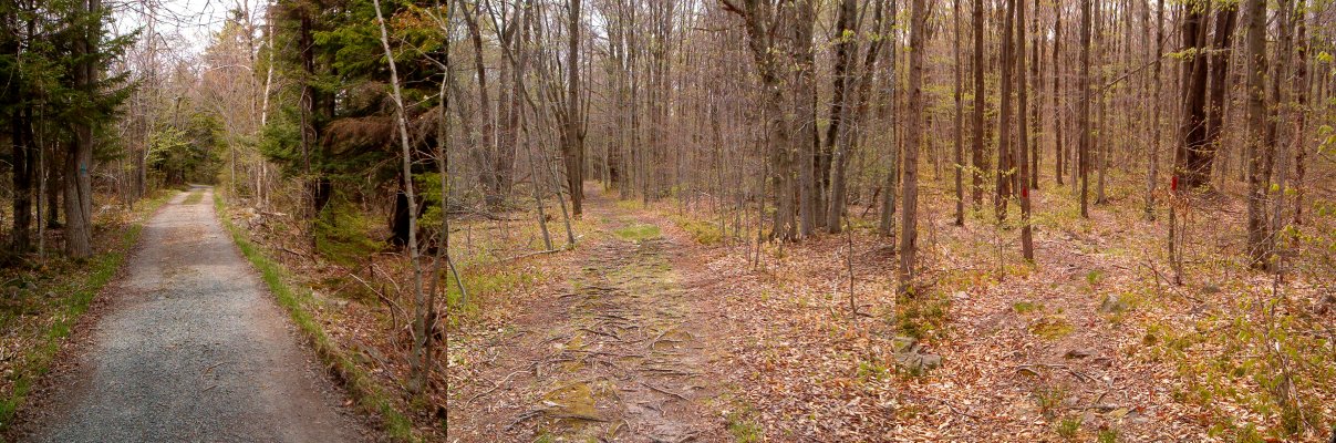
The trails in the park are well-marked; often half a dozen bright blazes of paint are visible at once. A 5.1 mi blue-blazed trail circles the lake; it is level, well-cleared and generally gravelled; "Although not recommended for persons with disabilities, wheelchair users have completed the trail" A 3.3 mi yellow-blazed trail extending northeast to Pennsylvania Route 196 and a 3.2 mi red-blazed trail linking the park to Gouldsboro State Park to the northwest are more difficult to pass due to tree roots and stones.
Soundscape
The park is close to Interstate 380 to the west-southwest, and the western portion of the park suffers frequent vehicular noise. Some vehicle noise is also present to the south of the lake from Pennsylvania Route 423. (Light plane traffic emanates from the Mount Pocono Municipal Airport, approximately 4 mi to the south. Other noise from park maintenance, constant restroom fans, vending machines, and residential neighbors affect the southern margin of the lake. The quietest portion of the park on marked trails is partway along the yellow trail north of its crossing of the Tobyhanna Creek, where natural sounds prevail a majority of the time.
Winter facilities
A 1.2 acre ice skating area and a 5.5 mi one-way snowmobile trail are designated during the winter. Ice fishing is popular, but ice thickness must be monitored by the user.
Hunting
Hunting is permitted on the park land and adjacent game lands except on Tobyhanna Lake and a small crescent of land to the east of Tobyhanna Lake. Signs demarcate the regions of the park where hunting is permitted, and admonish visitors to wear orange to be seen.
Accommodations
Five sites are available for organized group tenting of 20-40 people each. A 140-site camping area is available with hand-operated water pumps, flush toilets, and a dump station for trailers. There are several pet friendly sites. There is a pavilion and a separate picnic area, sandbeach, volleyball net as well as swimming in the Tobyhanna Lake.
References
References
- "2006 Railroad Map of Pennsylvania".
- "Pa. state parks going without life guards at beaches in 2008". [[Times Leader]].
- "Tobyhanna State Park". Pennsylvania Department of Conservation and Natural Resources.
This article was imported from Wikipedia and is available under the Creative Commons Attribution-ShareAlike 4.0 License. Content has been adapted to SurfDoc format. Original contributors can be found on the article history page.
Ask Mako anything about Tobyhanna State Park — get instant answers, deeper analysis, and related topics.
Research with MakoFree with your Surf account
Create a free account to save articles, ask Mako questions, and organize your research.
Sign up freeThis content may have been generated or modified by AI. CloudSurf Software LLC is not responsible for the accuracy, completeness, or reliability of AI-generated content. Always verify important information from primary sources.
Report