From Surf Wiki (app.surf) — the open knowledge base
Toamasina
| Field | Value | |
|---|---|---|
| <!--See the Table at Infobox Settlement for all fields and descriptions of usage--> | official_name | Toamasina |
| other_name | Tamatave | |
| motto | Lakana tsara voha manafak'onja | |
| ("A good boat, open to the waves") | ||
| image_skyline | Tamatave - panoramio.jpg | |
| imagesize | 300px | |
| image_caption | Toamasina | |
| image_shield | Toamasina.png | |
| shield_size | 150px | |
| pushpin_map | Madagascar | |
| pushpin_label_position | bottom | |
| pushpin_map_caption | Location in Madagascar | |
| pushpin_mapsize | 240 | |
| subdivision_type | Country | |
| subdivision_name | Madagascar | |
| subdivision_type1 | Region | |
| subdivision_name1 | Atsinanana | |
| subdivision_type2 | District | |
| government_footnotes | ||
| leader_title | Mayor | |
| leader_name | Nantenaina Rakotonirina | |
| area_total_km2 | 30.9 | |
| population_as_of | 2018 census | |
| population_total | 325857 | |
| population_density_km2 | auto | |
| population_blank1_title | Ethnicities | |
| population_blank1 | Betsimisaraka | |
| population_blank2_title | Religions | |
| timezone | EAT | |
| utc_offset | 3 | |
| coordinates | ||
| elevation_footnotes | ||
| elevation_m | 11 | |
| postal_code_type | Postal code | |
| postal_code | 501 | |
| area_code | +261 | |
| blank_name | Climate | |
| blank_info | Af |
("A good boat, open to the waves") Toamasina (), meaning "like salt" or "salty", unofficially and in French Tamatave or in the past as Port aux prunes, is the capital of the Atsinanana region on the east coast of Madagascar on the Indian Ocean. The city is the chief seaport of the country, situated 215 km northeast of its capital and largest city Antananarivo. In 2018 Toamasina had a population of 325,857.
History
Under French rule, Toamasina was the seat of several foreign consuls, as well as of numerous French officials, and was the chief port for the capital and the interior. Imports consisted principally of piece-goods, farinaceous foods, and iron and steel goods; main exports were gold dust, raffia, hides, caoutchouc (natural rubber) and live animals. Communication with Europe was maintained by steamers of the Messageries Maritimes and the Havraise companies, and also with Mauritius, and thence to Sri Lanka, by the British Union-Castle Line.
During the colonial period, owing to the character of the soil and the formerly crowded native population, the town was often plagued by epidemics; the plague broke out in 1898, and again in 1900. Since the draining of the neighboring marshes, there is some improvement, although there are still outbreaks of malaria and other diseases, such as chikungunya.
Notable person
- André Michaux (1746–1802), botanist and explorer, died in Tamatave.
Geography
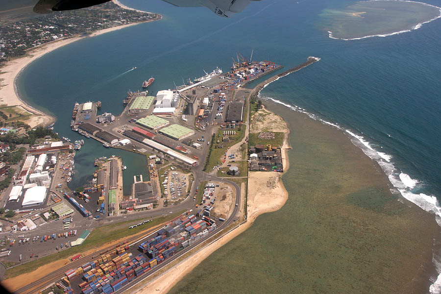
Toamasina owes its importance to the existence of a coral reef which forms a spacious harbour, entered by two openings. The city center is built on a sandy peninsula which projects at right angles from the general coastline.
South of the town there is the mouth of the Ivondro River in the Indian Ocean.
Climate
Toamasina features a trade-wind tropical rainforest climate under the Köppen climate classification. While Toamasina has no true dry season month where less than 60 mm of precipitation (on average) falls, the seaport has noticeably wetter and drier periods of the year. September–November is the driest period of the year, while February–April is the wettest time of the year. Average temperatures are relatively constant throughout the course of the year, though it is slightly cooler in the months of July and August, where average highs are around 24 C, and warmer in the months of January and February, where high temperatures on average are 30 C. Toamasina averages 3368.2 mm of precipitation annually. |Jan record high C = 37.4 |Feb record high C = 38.6 |Mar record high C = 39.0 |Apr record high C = 35.0 |May record high C = 34.0 |Jun record high C = 29.6 |Jul record high C = 31.2 |Aug record high C = 30.2 |Sep record high C = 30.6 |Oct record high C = 33.2 |Nov record high C = 33.0 |Dec record high C = 33.6 |year record high C = 39.0 |Jan record low C = 18.0 |Feb record low C = 17.5 |Mar record low C = 17.0 |Apr record low C = 15.0 |May record low C = 13.2 |Jun record low C = 11.0 |Jul record low C = 11.8 |Aug record low C = 10.0 |Sep record low C = 11.0 |Oct record low C = 11.0 |Nov record low C = 13.5 |Dec record low C = 16.0 |year record low C = 10.0 | access-date = 2 August 2023}}
Transport
The town is the railhead for the line to the capital. Pousse-pousse (bicycle rickshaws), tuk-tuk (motorized rickshaws), and taxis are available throughout Toamasina to get around the city. Toamasina is the northern end of the Canal des Pangalanes.
The port of Toamasina serves as Madagascar's most important gateway to the Indian Ocean and to the world.
The city is served by Ambalamanasy Airport, which has limited domestic and international service. The city is the country's main seaport for international shipping.
Roads
- National Road 2 leads westwards to Antananarivo
- National Road 5 leads northwards to Maroantsetra.
Education
The University of Toamasina was founded in 1977. There is also a Lycée Français de Tamatave, a French international school.
Hospitals
The CHU Morafeno is the university hospital of Toamasina.
Sports
The Barikadimy Stadium with a capacity 25,000 spectators. It mostly hosts football competitions and the AS Fortior and Tia Kitra FC Toamasina.
Places of worship
Among the places of worship, they are predominantly Christian churches and temples: Church of Jesus Christ in Madagascar, Malagasy Lutheran Church, Assemblies of God, Association of Bible Baptist Churches in Madagascar, Roman Catholic Archdiocese of Toamasina (Catholic Church seated in the Cathedral of St. Joseph) and Iglesia ni Cristo. There are also Muslim mosques.
Neighborhoods
- Anjoma
- Tanamakoa
- Tanambao V
- Mangarivotra
- Ankirihiry
- Manangareza
- Andranomadio
- Ambohijafy
International relations
Twin towns – Sister cities
Toamasina is twinned with:
- FRA Saint-Étienne, France
- Réunion Le Port, Réunion
Notes
References
References
- Rakotoarivelo, Julian. (2021-09-04). "Toamasina : Menace de destitution du maire de la ville".
- Estimated based on [[digital elevation model. DEM]] data from [[Shuttle Radar Topography Mission]]
- Census 2018
- "Klimatafel von Toamasina (Tamatave) / Madagaskar". Deutscher Wetterdienst.
- "Station Toamasina". Meteo Climat.
- https://www.mherrera.org/temp.htm
- J. Gordon Melton, Martin Baumann, ''Religions of the World: A Comprehensive Encyclopedia of Beliefs and Practices'', ABC-CLIO, USA, 2010, p. 1768
- link. (2015-09-08 {{in lang). fr
This article was imported from Wikipedia and is available under the Creative Commons Attribution-ShareAlike 4.0 License. Content has been adapted to SurfDoc format. Original contributors can be found on the article history page.
Ask Mako anything about Toamasina — get instant answers, deeper analysis, and related topics.
Research with MakoFree with your Surf account
Create a free account to save articles, ask Mako questions, and organize your research.
Sign up freeThis content may have been generated or modified by AI. CloudSurf Software LLC is not responsible for the accuracy, completeness, or reliability of AI-generated content. Always verify important information from primary sources.
Report