From Surf Wiki (app.surf) — the open knowledge base
Tierra del Fuego
Archipelago off the south of South America
Archipelago off the south of South America
| Field | Value |
|---|---|
| name | Tierra del Fuego archipelago |
| image_name | NASA Tierra del Fuego image.jpg |
| image_caption | Tierra del Fuego archipelago |
| at the tip of South America | |
| pushpin_map | Tierra del Fuego |
| pushpin_map_caption | Political map of Tierra del Fuego |
| and mainland South America | |
| location | Pacific Ocean, Atlantic Ocean |
| major_islands | Tierra del Fuego, Hoste, Navarino, Gordon, Wollastone, Noir, Staten, Hermite, Santa Inés, Clarence, Dawson, Capitán Aracena, Londonderry, Picton, Lennox, Nueva, Diego Ramírez, O'Brien, and Desolación Islands among many others |
| highest_mount | |
| country | Chile |
| country_admin_divisions_title | Region |
| country_admin_divisions | Magallanes y Antártica Chilena |
| country_admin_divisions_title_1 | Provinces |
| country_admin_divisions_1 | Tierra del Fuego Province and Antártica Chilena |
| country_admin_divisions_title_2 | Communes |
| country_admin_divisions_2 | Cabo de Hornos, Antártica, Porvenir, Primavera, Timaukel |
| country1 | |
| country1_admin_divisions_title | Province |
| country1_admin_divisions | Tierra del Fuego Tierra del Fuego Province |
| population | ~201,000 |
| population_as_of | 2022 |
| ethnic_groups | Argentines, Chileans, Selkʼnams, Kawésqar, Yaghans |
at the tip of South America and mainland South America
Tierra del Fuego (; ; ) is an archipelago off the southernmost tip of the South American mainland, across the Strait of Magellan.
The archipelago consists of the main island, Isla Grande de Tierra del Fuego, with an area of 73,746 km2, along with numerous smaller islands, including Cape Horn and Diego Ramírez Islands. The western part of the Tierra del Fuego archipelago, about two-thirds including its many islands, is part of Chile, and the eastern part is part of Argentina. The southernmost extent of the archipelago, Cape Horn, lies just north of 56° south.
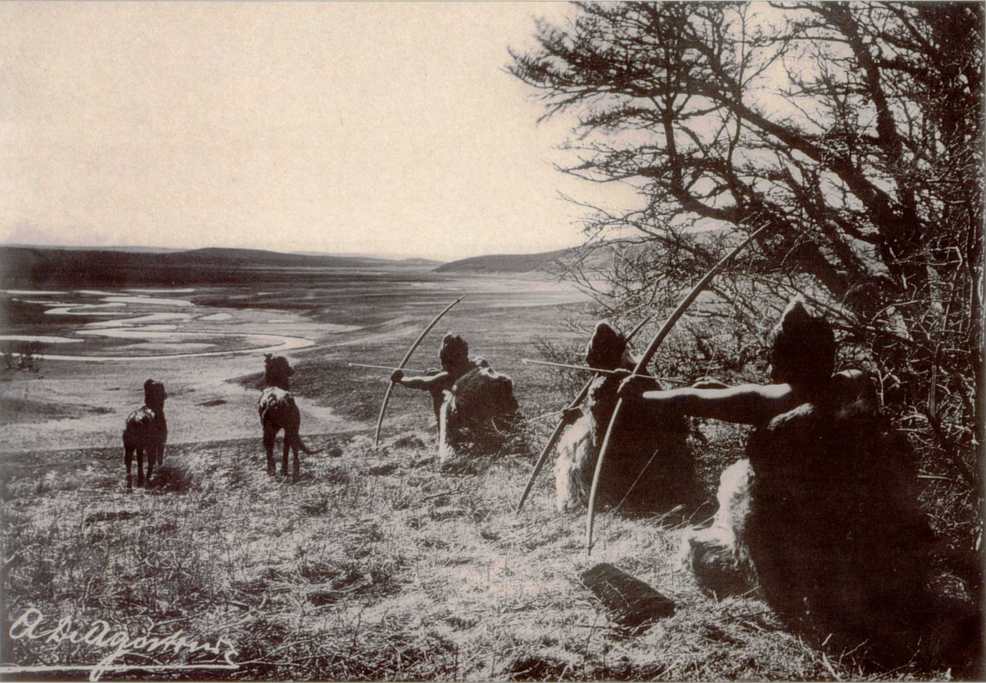
The earliest-known human settlement in Tierra del Fuego dates to . Europeans first explored the islands during Ferdinand Magellan's expedition of 1520. Tierra del Fuego ('Land of Fire') and similar names stem from sightings of the many fires that the inhabitants built along the coastline and possibly even in their canoes for warmth and signaling.
Settlement by those of European descent and the displacement of the native populations did not begin until the second half of the nineteenth century, at the height of the Patagonian sheep farming boom and of the local gold rush. Today, petroleum extraction dominates economic activity in the north of Tierra del Fuego, while tourism, manufacturing, and Antarctic logistics are important in the south.
History
Prehistory
Main article: Fuegians
The earliest human settlement occurred approximately 8,000 BC. The Yahgan were some of the earliest known humans to settle in Tierra del Fuego. Archaeological sites with characteristics of their culture have been found at locations such as Navarino Island.
European exploration

The name Tierra del Fuego was given by the Portuguese explorer Ferdinand Magellan while sailing for the Spanish Crown in 1520; he was the first European to visit these lands. He believed he was seeing the many fires (fuego is Spanish for "fire") of the Indigenous inhabitants, which were visible from the sea, and that the "Indians" were waiting in the forests to ambush his armada.
In 1525, Francisco de Hoces was the first to speculate that Tierra del Fuego was one or more islands rather than part of what was then called Terra Australis. Francis Drake in 1578 and a Dutch East India Company expedition in 1616 learned more about the geography. The latter expedition named Cape Horn at Hornos Island.
On his first voyage with in 1830, Robert FitzRoy picked up four native Fuegians, including "Jemmy Button" (Orundellico) and Yokcushlu, and brought them to England. The three who survived the voyage were taken to London to meet the king and queen and were, for a time, celebrities. They returned to Tierra del Fuego in the Beagle with FitzRoy and Charles Darwin, who made extensive notes about his visit to the islands.
European colonization and extinction of Native Americans (1860–1910)
During the second half of the nineteenth century, Salesian Catholic missions were established in Río Grande and Dawson Island.
Anglican missionaries, who had established missions on Keppel Island in 1855, established new missions in 1870 at Ushuaia. These missions continued to operate through the nineteenth century. Missionary Thomas Bridges (1842–1898) learned the native language and compiled a 30,000-word Yaghan grammar and dictionary while he worked at Ushuaia. It was published in the 20th century and is considered an important ethnological work.
An 1879 Chilean expedition led by Ramón Serrano Montaner reported large amounts of placer gold in the streams and river beds of Tierra del Fuego. This prompted massive immigration to the main island between 1883 and 1909. Numerous Argentines, Chileans, and Croatians settled on the main island, leading to increased conflicts with native Selkʼnam. These late nineteenth century gold rushes led to the founding of numerous small settlements by immigrants, such as the Argentine settlements of Ushuaia and Río Grande and the Chilean settlements of Porvenir and Puerto Toro.
Julius Popper, a Romanian explorer, was one of the most successful entrepreneurs in the region. Granted rights by the Argentine government to exploit any gold deposits he found in Tierra del Fuego, Popper has been identified as a central figure in the Selkʼnam genocide.
Following contact with Europeans, the native Selkʼnam and Yaghan populations were greatly reduced by unequal conflict and persecution by settlers, by infectious diseases to which the Indigenous people had no immunity, and by mass transfer to the Salesian mission of Dawson Island. Despite the efforts of the missionaries, many natives died. Today, only a few Selkʼnam remain. Some of the few remaining Yaghan have settled in Villa Ukika in Navarino Island; others have scattered throughout Chile and Argentina.
Following the signing of the Boundary Treaty of 1881, Tierra del Fuego was divided between Argentina and Chile; previously, it had been claimed in its entirety by both countries.
Recent history (1940–present)
In 1945, a division of Chilean CORFO (Spanish acronym for Production Development Corporation), engaged in oil exploration, discovered oil in northern Tierra del Fuego. Extraction began in 1949 and, in 1950, the Chile state-owned ENAP (National Petroleum Company). Until 1960, most oil extracted in Chile came from Tierra del Fuego.{{Citation | author-link = Mateo Martinic
Geography


The archipelago consists of a main island, Isla Grande de Tierra del Fuego, often simply called Tierra del Fuego or Isla Grande, with an area of 48100 km2, and a group of smaller islands. Of the main island the westernmost 29,484.7 km2 (11,384, 61.43%) belongs to Chile, and 18,507.3 km2 (7,146, 38.57%) belongs to Argentina. The archipelago is divided by an east–west channel, the Beagle Channel, immediately south of the main island. The largest islands south of the Beagle Channel are Hoste and Navarino.
The western part of the main island, and almost all the other islands, belong to Chile. They are part of the Magallanes y Antártica Chilena Region, the capital and chief town of which is Punta Arenas, situated on the mainland across the strait. The largest Chilean towns are Porvenir, capital of the Chilean Province of Tierra del Fuego, located on the main island, and, on Navarino Island, Puerto Williams, which is the capital of the Antártica Chilena Province.
Puerto Toro lies a few kilometers south of Puerto Williams. Arguably, it is the southernmost village in the world. The mostly uninhabited islands north and west of the main island are part of Magallanes Province.
The eastern part of the main island and a few small islands in the Beagle Channel belong to Argentina. They are part of the Tierra del Fuego, Antarctic Territory and South Atlantic Islands Province, whose capital is Ushuaia. The other important city in the region is Río Grande on the Atlantic coast, the largest in the archipelago.
The Cordillera Darwin in the southwestern part of the main island contains many glaciers that reach the ocean. While Mount Darwin had previously been thought to be the tallest mountain in the archipelago, this distinction now belongs to the unofficially named Monte Shipton at 2580 m.{{Cite journal | access-date = 28 March 2012 | archive-date = 19 April 2014 | archive-url = https://web.archive.org/web/20140419221728/http://www.alpinejournal.org.uk/Contents/Contents_2004_files/AJ%202004%20132-142%20Shipton%20Cord%20Darwin.pdf | url-status = live
The topography of Tierra del Fuego can be divided into four regions: an outer archipelago region () to the south and west, a mountainous region in the south (), a plains region () plus a sub-Andean zone in-between the last two zones ().
Geology
The geology of the archipelago is influenced by the effects of the Andean orogeny and the repeated Pleistocene glaciations. The geology of the island can be divided into large east–west-oriented units. The southwestern islands of the archipelago, including Cape Horn, are part of the South Patagonian Batholith, while the Cordillera Darwin and the area around the Beagle Channel form the principal mountain range hosting the highest mountains. The Magallanes fold and thrust belt extends north of Almirantazgo Fjord and Fagnano Lake, and north of this lies the Magallanes foreland, an old sedimentary basin that hosts hydrocarbon reserves. Orthogneiss dated at 525 million years is known to underlie some of the oil wells in northern Tierra del Fuego.
The Magallanes–Fagnano Fault, a sinistral strike slip fault crosses the southern part of the main island from west to east. It is an active fault, located inside and parallel to the Fuegian fold and thrust belt, and marks the boundary between a southern belt of Paleozoic meta sediments and a northern Mesozoic belt of sedimentary sequences. Fagnano Lake occupies a glacier-carved depression in a pull-apart basin that has developed along the Magallanes-Fagnano Fault zone.
Podzols and inceptisols occur beneath Nothofagus betuloides forests in Tierra del Fuego.{{Citation |doi-access= free
Climate

The Tierra del Fuego region has a subpolar oceanic climate (Köppen climate classification Cfc) with short, cool summers and long, wet, moderately mild winters: the precipitation averages 3000 mm a year in the far west, but precipitation decreases rapidly towards the eastern side. Temperatures are steady throughout the year: in Ushuaia they hardly surpass 9 °C in summers and average 0 °C in winters. Snowfall can occur in summer. The cold and wet summers help preserve the ancient glaciers. The southernmost islands possess a sub-antarctic climate typical of tundra that makes the growth of trees impossible. Some areas in the interior have a polar climate. Regions in the world with similar climates to southern Tierra del Fuego are: the Aleutian Islands, Iceland, the Alaska Peninsula, the Faroe Islands, Macquarie Island, and the Heard and McDonald Islands.
Flora
Only 30% of the islands have forests, which are classified as Magellanic subpolar. The northeastern portion of the region is made up of steppe and cool semi-desert.
Six species of tree are found in Tierra del Fuego: canelo or winter's bark (Drimys winteri); Maytenus magellanica; Pilgerodendron uviferum, the southernmost conifer in the world; and three kinds of southern beech: Nothofagus antarctica; Nothofagus pumilio; and the evergreen Nothofagus betuloides. Several kinds of fruit grow in open spaces in these forests, such as beach strawberry (Fragaria chiloensis var. chiloensis forma chiloensis) and calafate (Berberis buxifolia), which have long been gathered by both Native Americans and residents of European descent.
They are the only forests in the world to have developed in a climate with such cold summers. Tree cover extends very close to the southernmost tip of South America. Winds are so strong that trees in wind-exposed areas grow into twisted shapes, inspiring people to call them "flag-trees". Tree vegetation extends to the southern tip of the region, Isla Hornos, although the Wollaston Islands are mostly covered by subantarctic tundra except in wind sheltered areas where the trees can survive.
File:Drimys winteri.jpg|Drimys winteri flowers File:Nothofagus antarctica D.jpg|Nothofagus antarctica File:Nothofagus pumilio.jpg|Nothofagus pumilio File:Nothofagus betuloides.jpg|Nothofagus betuloides
Forests from Tierra del Fuego have expanded beyond local importance. These forests have been a source of trees that have been transplanted abroad in places with similar climate, but which originally were devoid of trees, such as the Faroe Islands and nearby archipelagos. Most species were gathered from the coldest places in Tierra del Fuego, mainly sites with tundra borders. This effort resulted in positive changes, as the heavy winds and cool summers in the Faroe Islands did not allow the growth of trees from other regions in the world. The imported trees are used ornamentally, as curtains against wind, and to fight erosion caused by storms and grazing in the Faroe Islands.
Fauna

Among the most notable animals in the archipelago are austral parakeets, gulls, guanacos, South American foxes, kingfishers, Andean condors, king penguins, owls, and firecrown hummingbirds. Isla Grande de Tierra del Fuego is also home to the lizard with the world's southernmost distribution, Liolaemus magellanicus.
North American beavers, introduced during the 1940s, have proliferated and caused considerable damage to the island forests. The governments have established a wide-reaching program to trap and kill beavers in Tierra del Fuego.
Like the mainland of Chile and Argentina to the north, this archipelago boasts some of the finest trout fishing in the world. Sea-run brown trout often exceed 9 kg, particularly in rivers such as the Rio Grande and the San Pablo, and in the Lago Fagnano.
Waters adjacent to Tierra del Fuego are very rich in cetacean diversity. Sightings of southern right whales in Tierra del Fuego have increased in the 2000s, humpbacks, and some others such as blue whales, southern fins, southern seis, and southern minkes. Beagle Channel is a prominent area to watch rare, endemic dolphins, and the less-studied pygmy right whales.
Pinnipeds inhabiting the areas include South American sea lions (Otaria flavescens), South American fur seals (Arctophoca australis), the carnivorous and seal-eating leopard seals (Hydrurga leptonyx), and gigantic southern elephant seals (Mirounga leonine)the largest extant marine mammal that is not a cetacean.
Islands
The following table lists islands over 1 . Area figures are from the USGS unless otherwise specified.
| Island | Area() | Group |
|---|---|---|
| Isla Grande | 47,369.9 | main island |
| Hoste Island | 4,261.4 | |
| Santa Inés Island | 2,734.5 | |
| Navarino Island | 2,519.7 | |
| Dawson Island | 1,523.1 | |
| Desolación Island | 1,367.0 | |
| Aracena Island | 1,291.8 | |
| Clarence Island | 1,165.2 | |
| Londonderry Island | 631.5 | |
| Gordon Island | 618.1 | |
| Isla de los Estados | 485.0 | |
| Guardián Brito Island | 218.9 | |
| Wollaston Island | 214.4 | Wollaston Islands |
| Lennox Island | 148.0 | Picton, Lennox and Nueva |
| O'Brien Island | 142.0 | |
| Hermite Island | 137.6 | Hermite Islands |
| Nueva Island | 110.9 | Picton, Lennox and Nueva |
| Picton Island | 88.1 | Picton, Lennox and Nueva |
| Hevia Island | 79.5 | |
| Carlos III Island | 69.7 | |
| Recalada Island | 69.4 | |
| Cook Island | 68.9 | |
| Grevy Island | 65.3 | Wollaston Islands |
| Herschel Island | 62.4 | Hermite Islands |
| Bayly Island | 43.8 | Wollaston Islands |
| Deceit Island | 36.9 | Hermite Islands |
| Hornos Island | 24.5 | Hermite Islands |
| Gable Island | 21.7 | |
| Freycinet Island | 18.2 | Wollaston Islands |
| Adriana Island | 18.2 | Wollaston Islands |
| Jerdan Island | 4.9 | Hermite Islands |
| Hall Island | 2.6 | Hermite Islands |
| Barnevelt Island | 1.6 | |
| Maxwell Island | 1.4 | Hermite Islands |
| Evout Island | 1.3 | |
| Middle Island | 1.2 | Wollaston Islands |
| Otarie Island | 1.0 | Wollaston Islands |
Economy
Today, the main economic activities of the archipelago are fishing, extraction of natural gas and oil, sheep farming, and ecotourism. Tourism is gaining increasing importance as it attracts numerous upmarket visitors. Much of the tourism is based on "southernmost" claims: for example, both Ushuaia and Puerto Williams claim to be the "southernmost city in the world". On the Argentine side of Tierra del Fuego, the government has promoted the establishment of several electronic companies via tax exemptions, particularly in the city of Río Grande.
Energy production is a crucial economic activity. On the Argentine side of Tierra del Fuego during the period 2005–2010, petroleum and natural gas extraction contributed 20% of the region's economic output.
Cultural depictions
- Alexander Buchan participated in the 1768–1771 first voyage of James Cook aboard , where he was one of the artists in the entourage of botanist Joseph Banks. Endeavour lay at anchor in the Bay of Good Success on 15 January 1769. He took part in an expedition which started from here.
- As a ship painter, Conrad Martens drew and created watercolour paintings in 1833 and 1834 during the second voyage of HMS Beagle in Tierra del Fuego.
- The French painter and lithographer Évremond de Bérard illustrated the travel journal "Le Tour du Monde" with Tierra del Fuego motifs in 1861.
- Rockwell Kent painted "more than twenty large pictures of Tierra del Fuego" during his stay there in 1922 and 1923, as he reported in his autobiography It's Me O Lord: The Autobiography of Rockwell Kent.
- The German painter Ingo Kühl travelled three times to Tierra del Fuego, where he created paintings in a cycle entitled Landscapes of the End of the World (2005). File:Endeavour off the Coast of Tierra del Fuego.jpg|Alexander Buchan HMS Endeavour on 12 January 1769, off the coast of Tierra del Fuego File:Inhabitants of Tierra del Fuego Alexander Buchan BL Add MS 23920.jpg|Alexander Buchan Inhabitants of Tierra del Fuego, 1769 File: HMS Beagle by Conrad Martens.jpg | Conrad Martens HMS Beagle in Tierra del Fuego, between 1832 and 1836 File:Le Tour du monde-03-p232.jpg| Évremond de Bérard Tierra del Fuego, Monte Sarmiento seen from Froward Cape, 1861 File: Ingo Kühl "Gletscher (Beagle Kanal)" 2005.jpg |Ingo Kühl Glacier (Beagle Channel), 2005 painted in Punta Arenas
Footnotes
Notes
References
- Bridges, Lucas. 1948. Uttermost Part of the Earth. Reprint with introduction by Gavin Young, Century Hutchinson, 1987.
- Keynes, Richard. 2002. Fossils, Finches and Fuegians: Charles Darwin's Adventures and Discoveries on the Beagle, 1832–1836. HarperCollins Publishers, London. Reprint: 2003.
- Bollen, Patrick. 2000. "Tierra del Fuego" B/W Photobook. Lannoo Publishers, Tielt, Belgium.
References
- also rarely called ''Fireland'' in English{{cn. (December 2025)
- "Tierra del Fuego".
- (2012-03-01). "Hunter-gatherers, biogeographic barriers and the development of human settlement in Tierra del Fuego". [[Antiquity (journal).
- (2017-04-11). "8 Facts You Never Knew About the Tierra del Fuego Archipelago". Australis [[S.A. (corporation).
- Kelly, James. (2017-06-05). "In Search of Paradise Lost in Tierra del Fuego". [[Earth Island Institute]].
- Iparraguirre, Sylvia. (2024-03-19). "Tierra del fuego: a biography of the end of the world". Photo Design Ediciones - Florian von der Fecht.
- Hogan, C. Michael. (4 April 2008). "Bahia Wulaia Dome Middens". Megalithic Portal.
- Bergreen, Laurence. (2003). "Over the Edge of the World: Magellan's Terrifying Circumnavigation of the Globe". HarperCollins.
- Woram, John. (2009). "Here Be Giants: Travelers' Tales from the Land of the Patagons". Rockville Press, Incorporated.
- Woram, John. (2012). "Some Place Names from Early Voyages to Patagonia and Tierra del Fuego".
- (21 May 1910). "Cook Tried to Steal Parson's Life Work". The New York Times.
- "Historia de Tierra del Fuego". Tierradelfuego.gov.ar.
- [[#Pisano1977. Pisano (1977)]], p. 124
- [[#Pisano1977. Pisano (1977)]], p. 128
- [[#Pisano1977. Pisano (1977)]], p. 125
- (March 2008). "Structural geology of the Fuegian Andes and Magallanes fold-and-thrust belt – Tierra del Fuego Island". [[Geologica Acta]].
- [[Francisco Hervé. Hervé, Francisco]]; Miller, Hubert; Pimpirev Christo. 2003. Patagonia – Antarctica Connections before Gondwana Break-Up in Antarctica Contributions to Global Earth Sciences. Chapter 5.1
- Lodolo, Emanuele. (2003). "Magallanes-Fagnano continental transform fault (Tierra del Fuego, southernmost South America)". Tectonics.
- Martínez Crovetto, Raúl. 1968. ''Estudios Etnobotánicos. Nombres de plantas y su utilidad según los indios Onas de Tierra del Fuego'', Revista de la Facultad de Agronomía y Veterinaria de la Universidad del Nordeste, Corrientes, Argentina
- Højgaard, A., J. Jóhansen, and S. Ødum (eds) 1989. ''A Century of Tree Planting in the Faroe Islands'', Føroya Frodskaparfelag, Tórshavn.
- IUCN. (2016-02-03). "Lama guanicoe: Baldi, R.B., Acebes, P., Cuéllar, E., Funes, M., Hoces, D., Puig, S. & Franklin, W.L.: The IUCN Red List of Threatened Species 2016: e.T11186A18540211".
- IUCN. (2016-10-01). "Sephanoides sephaniodes: BirdLife International: The IUCN Red List of Threatened Species 2016: e.T22687857A93172170".
- Jaksic, Fabian M.. (2022). "Historical account and current ecological knowledge of the southernmost lizard in the world, Liolaemus magellanicus (Squamata: Liolaemidae)". [[Revista Chilena de Historia Natural]].
- Strieker, Gary. (9 July 1999). "Argentina eager to rid island of beavers". Cable News Network.
- Schiavini, Adrian. "ARGENTINA. PROGRESS REPORT ON CETACEAN RESEARCH, JUNE 2000 TO JUNE 2001".
- (18 April 2009). "Hoy en Rio Grande, Tierra del Fuego (ballena)".
- (17 January 2014). "The Presence of Southern Right Whales off Eastern Tierra del Fuego, 1987–2011".
- "Whale Watching in the Southern Cone – Argentina".
- "Whale Watching in the Southern Cone – Gallery".
- "Blue Whale (''Balaenoptera musculus'') on Tierra del Fuego Check List".
- (9 December 2011). "Minke Whale (Sei Whale?)".
- "Minke Whale (''Balaenoptera acutorostrata'') on Tierra del Fuego Check List".
- "Record of a dwarf minke whale (''Balaenoptera acutorostrata'') in northern Brazil".
- "Scotia Sea: Part 5. The Great Marine Mammals".
- "Sailing to the Sea Lions and Les Eclaireurs Lighthouse in Catamarans".
- (25 September 2011). "Southern Sea Lions: Tierra del Fuego, Argentina".
- (28 February 2003). "Mark Horrell: Tierra del Fuego".
- "Ballenas en el Canal de Beagle".
- "Ushuaia Photo: leopard seal".
- (25 February 2011). "Expedition Uncovers Wildlife Wonders at Tierra del Fuego".
- "Cruceros Australis – Fjords of Tierra del Fuego, Patagonia & Cape Horn, Punta Arenas – Ushuaia – Punta Arenas".
- "Global Island Explorer".
- "Instituto Nacional de Estadística y Censos".
- [[Richard Keynes]]: ''The Beagle Record: Selections from the Original Pictorial Records and Written Accounts of the Voyage of H.M.S. Beagle'', 1979, CUP Archives {{ISBN. 0-521-21822-5
- (2014). "A Voyage of Sketches: The Art of Conrad Martens". Cambridge Digital Library.
- Kühl, Ingo. (2006). "Landschaften am Ende der Welt / Paisages del fin del mundo / mit einem Text von / con un texto de Antonio Skármeta". I. Kühl.
This article was imported from Wikipedia and is available under the Creative Commons Attribution-ShareAlike 4.0 License. Content has been adapted to SurfDoc format. Original contributors can be found on the article history page.
Ask Mako anything about Tierra del Fuego — get instant answers, deeper analysis, and related topics.
Research with MakoFree with your Surf account
Create a free account to save articles, ask Mako questions, and organize your research.
Sign up freeThis content may have been generated or modified by AI. CloudSurf Software LLC is not responsible for the accuracy, completeness, or reliability of AI-generated content. Always verify important information from primary sources.
Report