From Surf Wiki (app.surf) — the open knowledge base
Theophilus (crater)
Lunar surface depression

Lunar surface depression
| Field | Value |
|---|---|
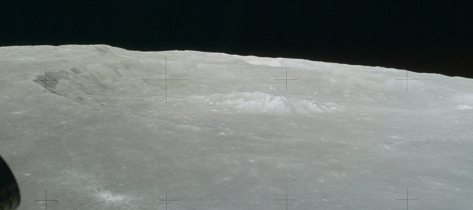
| image | Crater Theophilus.jpg |
| caption | Oblique view facing south from Apollo 16 |
| coordinates | |
| diameter | 100 km |
| depth | 3.2 km |
| colong | 333 |
| eponym | Theophilus I of Alexandria |


Theophilus is a prominent lunar impact crater that lies between Sinus Asperitatis in the north and Mare Nectaris to the southeast. It partially intrudes into the comparably sized crater Cyrillus to the southwest. To the east is the smaller crater Mädler and further to the south-southeast is Beaumont.{{cite web | title=Moon - Theophilus crater region | work=astrosurf.com | url=http://www.astrosurf.com/antilhue/moon-theophilus.htm | accessdate=October 16, 2007 }} It was named after the 4th-century Coptic Pope Theophilus I of Alexandria.
Theophilus, Cyrillus and Catharina form a prominent group of large craters visible on the terminator 5 days after the new moon.
Description
The rim of Theophilus has a wide, terraced inner surface that shows indications of landslips. It is 4200 metres deep with massive walls and has broken into a second formation, Cyrillus. It was created during the Eratosthenian period, from 3.2 to 1.1 billion years ago. It has an imposing central mountain, 1,400 metres high, with four summits.
The floor of the crater is relatively flat, and it has a large, triple-peaked central mountain that climbs to a height of about 2 kilometres above the floor. The western peak is designated Psi (ψ), the eastern Phi (φ), and the northern peak is Alpha (α) Theophilus. The western slopes of this ridge are wider and more irregular, whereas the peaks descend more sharply to the floor on the northern and western faces.
The Apollo 16 mission collected several pieces of basalt that are believed to be ejecta from the formation of Theophilus.{{cite web | title=Apollo 16 Mission | work=Lunar and Planetary Institute | url=http://www.lpi.usra.edu/lunar/missions/apollo/apollo_16/samples/ | accessdate=October 16, 2007 }}
Satellite craters
By convention these features are identified on lunar maps by placing the letter on the side of the crater midpoint that is closest to Theophilus.{{cite book | author=Bussey, B. | author-link=Ben Bussey
| Theophilus | Latitude | Longitude | Diameter |
|---|---|---|---|
| B | 10.5° S | 25.2° E | 8 km |
| E | 6.8° S | 24.0° E | 21 km |
| F | 8.0° S | 26.0° E | 13 km |
| G | 7.2° S | 25.7° E | 19 km |
| K | 12.5° S | 26.3° E | 6 km |
| W | 7.8° S | 28.6° E | 4 km |
References
References
- ''Autostar Suite Astronomer Edition''. CD-ROM. Meade, April 2006.
- Moore, Patrick (2001). ''On the Moon''. Sterling Publishing Co.. {{ISBN. 0-304-35469-4.
- [https://pubs.er.usgs.gov/publication/pp1348 The geologic history of the Moon]. [[USGS]] Professional Paper 1348. By [[Don Wilhelms. Don E. Wilhelms]], John F. McCauley, and Newell J. Trask. U.S. Government Printing Office, Washington: 1987. Table 12.2.
- Rükl, Antonín. (1990). "Atlas of the Moon". [[Kalmbach Books]].
This article was imported from Wikipedia and is available under the Creative Commons Attribution-ShareAlike 4.0 License. Content has been adapted to SurfDoc format. Original contributors can be found on the article history page.
Ask Mako anything about Theophilus (crater) — get instant answers, deeper analysis, and related topics.
Research with MakoFree with your Surf account
Create a free account to save articles, ask Mako questions, and organize your research.
Sign up freeThis content may have been generated or modified by AI. CloudSurf Software LLC is not responsible for the accuracy, completeness, or reliability of AI-generated content. Always verify important information from primary sources.
Report