From Surf Wiki (app.surf) — the open knowledge base
Texas Gulf Coast
Texas coastal boundary with Gulf of Mexico

Texas coastal boundary with Gulf of Mexico
| Field | Value | ||
|---|---|---|---|
| name | Texas Gulf Coast | ||
| other_name | Beaches of Texas | ||
| type | Region | ||
| photo | {{multiple image | perrow=2 | total_width=350 |
| border | infobox | ||
| image1 | Ocean Drive to Indianola, TX.jpg | ||
| alt1 | Ocean Drive at Matagorda Bay | ||
| image2 | AerialCorpusChristi.jpg | ||
| alt2 | Corpus Christi Bay | ||
| image3 | Powhatan House Galveston.jpg | ||
| alt3 | Plants in bloom at Galveston Garden Club historic site | ||
| image4 | Gulf Intracoastal Waterway Galveston Bay.jpg | ||
| alt4 | Gulf Intracoastal Waterway at Galveston Bay | ||
| image5 | Queen Isabella Causeway.jpg | ||
| alt5 | Queen Isabella Causeway route to South Padre Island | ||
| image6 | 20150715 Port Isabel Aerial Photo IMG 6462 by sebaso.jpg | ||
| alt6 | Lower Rio Grande & Port Isabel, Texas | ||
| image7 | Bolivar Ferry.jpg | ||
| alt7 | Galveston-Port Bolivar Ferry | ||
| image8 | Padre Island National Seashore - sand dunes3.jpg | ||
| alt8 | Sand dunes at Padre Island National Seashore | ||
| image9 | An aerial view of South Padre Island with people parked and driving on the beach at sunset.jpg | ||
| alt9 | Sunset at South Padre Island | ||
| image10 | Elissa-Sailing-Ship.jpg | ||
| alt10 | The Elissa at Galveston Island | ||
| map | Texas | ||
| map_caption | Texas Marginal Seacoast | ||
| relief | Y | ||
| label | Texas Coast | ||
| label_position | right | ||
| coordinates | |||
| water_bodies | Gulf of Mexico | ||
| elevation_ft | |||
| surface_elevation_ft | |||
| length | |||
| area | 2149760 acre | ||
| geology | |||
| website |
| volcanic_arc/belt = Texas Gulf Coast is an intertidal zone which borders the coastal region of South Texas, Southeast Texas, and the Texas Coastal Bend. The Texas coastal geography boundaries the Gulf of Mexico encompassing a geographical distance relative bearing at 367 mi of coastline according to CRS and 3359 mi of shoreline according to NOAA.
Administrative divisions of Texas Gulf Coast
There are 14 Texas counties encompassing the Gulf of Mexico coastal boundary;
| Jefferson | Willacy |
|---|
Topography of Texas Gulf Coast
The Texas coastal bend sustains the Texas–Gulf water resource region as a hydrological cycle unifying a drainage basin of river deltas at the littoral zone of the Texas Gulf Coast.
Texas coastal management and impact resiliency
In accordance with the Coastal Zone Management Act and Coastal Barrier Resources Act, the Texas Gulf shores maintain a coastal management program striving to prohibit coastal erosion, coastal hazards, sea-level rise, and tidal flooding. The Texas beach observed the initial coastal bulkhead and construction of the Galveston Seawall subsequently to the 1900 hurricane and 1915 hurricane levying a direct catastrophic impact at Galveston Island. The Texas surf exemplifies a coastal defence with a seawall at North Padre Island, retaining wall at South Padre Island, and a revetment at Sargent Beach.
Imagery of Texas Early 20th Century Hurricanes
Texas Gulf Bays and Coastal Waterways
Beginning in December 1845 concurrent to Texas annexation, the United States Congress authorized federal articles creating coastal collective districts judiciously orchestrating ports of delivery for the Texas Gulf Coast. The United States statutes were enacted into law by the 11th President of the United States James Polk.
| Date of Enactment | Public Law No. | Statute Citation | U.S. Presidential Administration |
|---|---|---|---|
| December 31, 1845 | P.L. 29-2 | James K. Polk | |
| March 3, 1847 | P.L. 29-57 | James K. Polk | |
| March 3, 1849 | P.L. 30-122 | James K. Polk |
The Texas gulf coast has a geography of ten coastal bays while naturally bountiful with waterway inlets;
| Galveston Bay | South Bay |
|---|
Waterway inlets of Texas Barrier Islands

The Texas coastal bend has a geography of waterways fringed by the Texas barrier islands. The Texas seacoast is collectively multitudinal with navigable straits traversing watercraft access as a concourse to the Gulf Intracoastal Waterway and the Texas estuaries.
| Fish Pass | Sunday Beach Pass |
|---|
National and state parks of Texas Gulf Shores
The Texas Parks and Wildlife Department oversees the Texas state parks located on the Gulf of Mexico shores with the exception of Padre Island seashore, which is maintained by the National Park Service.

| Mustang Island State Park | Sea Rim State Park |
|---|
Nature sanctuaries of Texas Coastal Zones
The United States Fish and Wildlife Service governs the nature reserves as land parcels of the National Wildlife Refuge System bordering the Texas coastal zones.
| Laguna Atascosa Wildlife Refuge | Texas Point Wildlife Refuge |
|---|
Antiquity of Texas Gulf Coast
European Colonization of Texas Coast
North American expeditions and exploratory endeavors emerged with the europeans engaging their efforts for transatlantic crossings during the late fifteenth century.
Exploration of Spanish Conquistador
The Texas marginal seacoast acknowledged the arrival or entradas of Álvar Núñez Cabeza de Vaca during the first quarter century of the 1500s. Cabeza de Vaca, a Spanish conquistador and a successor of Christopher Columbus, embarked on a calamitous coastal ship landing near the shore of Galveston Island on November 6, 1528.
New Spain economic currency and perils of Spanish Sea
In 1554, a Spanish cargo ship known as the San Esteban was tacking from Veracruz due north along the Texas Gulf Coast with an eastern destination at Havana and the West Indies. The New Spain galleon encountered a severe tropical cyclone in the Spanish Sea proximate the 27th parallel north and 97th meridian west decimating the Spanish treasure fleet known as Espiritu Santo, San Estaban, and Santa Maria de Yciar. The shipwreck derelict is entitled as a National Register of Historic Places. The underwater archaeology site was established as the Mansfield Cut Underwater Archeological District at Padre Island National Seashore in 1974.
Expedition of France Monarchy
The Texas oceanic basin was colonized by the France monarchy or Louis XIV from 1684 to 1689. In 1684, Robert Cavelier de La Salle sailing under the French ensigns guided an expedition in the Spanish Sea of four ships known as L'Aimable, La Belle, Le Joly, and St. François. La Salle and Henri de Tonti were pursuing the Mississippi River Delta seeking to discover the French colonial empire of New France. In 1685, La Salle navigated beyond the Atchafalaya Basin and lower Mississippi River basin inaccurately discovering Matagorda Bay where the French cargo vessels anchored near Indianola, Texas. During 1685 to 1689, the La Salle colonists adventured north of Lavaca Bay establishing a land settlement known as Fort St. Louis near Garcitas Creek and Inez, Texas ratifying the French colonization of Texas.
Spanish Empire and Transformation of North Americas
The Texas Gulf coast attested to a second wave of the European colonization of the Americas with the introduction of colonialism by the Spanish Empire in 1690. The España cultural evolution substantiated a christianization or religious conquest by the transatlantic crossing of the Spanish Inquisition. The España colonization established the Viceroyalty of New Spain administratively structuring an interior province known as Spanish Texas from 1690 to 1821. Beginning in 1810, the Mexican War of Independence was settled with the Spanish Empire ennobling a discontinuation of the Mexican Inquisition while creating the First Mexican Empire in 1821.
History
French Corsairs of Gulf Waters and Texas Shores
The Texas Gulf coast served as a sanctuary for seafaring buccaneers, corsairs, privateers, and other practitioners of piracy during the Age of Sail. Galveston Bay and Matagorda Bay were the Texas coast fertile crescent for anchorage and concealment of the barque, barquentine, and brigantine class sailing vessels.

In the early nineteenth century, Jean Lafitte and Pierre Lafitte, kinship of french basque and sea-going privateers, managed a modest metal forging establishment known as the Lafitte's Blacksmith Shop in the New Orleans French Quarter.
In 1807, the 10th United States Congress obtained a consensus on the Embargo Act of 1807. America's international relations legislation and Orders in Council of 1807 coerced the displacement of the Dominique You, Vincenzo Gambi, and Lafitte's piracy venture to Barataria, Louisiana geographically south of New Orleans within the Mississippi River Delta region. By 1808, the Lafittes' discovered brigandage to be an invaluable endeavor smuggling pirate booty from Barataria Bay to New Orleans.
In 1814, Jean Lafitte received a written appeal from Royal Marines officer Edward Nicolls beckoning loyalty for the Royal Navy breach at the Battle of New Orleans. On September 16, 1814, Commodore Daniel Patterson received orders to launch a naval offensive on the Baratarian's prize of war enterprise debilitating the Lafitte's French corsair sailing fleet. { "type": "Feature", "geometry": { "type": "Point", "coordinates": [-89.92924, 29.28189] }, "properties": { "title": "Baratarians Pirates Haven", "marker-color": "40e0d0", "marker-size": "medium", "marker-symbol": "danger" } } After the remnants of the War of 1812, Jean Lafitte departed Grand Terre Island and the wetlands of Louisiana setting the sails for Galveston Island, Texas. The French Corsair's Galveston Island arrival was an antecedent to the 1816 Galveston inhabitants of Francisco Xavier Mina and Louis-Michel Aury. In early 1817, freebooter Jean Lafitte established a piracy colony at Galveston Island where the infamous Maison Rouge was built for his domicile.
Lafitte constructed the Maison Rouge structure perpendicular of the Galveston Channel and Pelican Island with the surroundings of a corsair's piracy settlement. The Brethren of the Coast discovered the Galveston landscape to be conducive for passage to the gulf waters supporting sailing ship tactics to intercept merchant ships and Spanish Empire armadas accomplishing the nautical journey from the Old World.
After the Galveston Hurricane of 1818, French privateer Lafitte abandoned Galveston Bay for the Bay of Campeche beseeching safe conduct at the cays of Campeche Bank. By 1821, the Texas seacoast exodus was resolutely coerced by the authorization of the 15th United States Congress legislative article known as the Piracy Suppression Act of 1819 enacted into law by United States President James Monroe on March 3, 1819.
In 1927, Galveston's William Moody Jr. erected the Jean Lafitte Hotel in the Galveston's Strand Historic District in recognition of Lafitte's origins on the Galveston Island shores.
Mexico Governance, Texas Revolution, and Republic of Texas
The first stirrings of the Texas Revolution began with the Fredonian Rebellion, occurring from 1826 to 1827 in the East Texas vicinity of Nacogdoches, Texas.
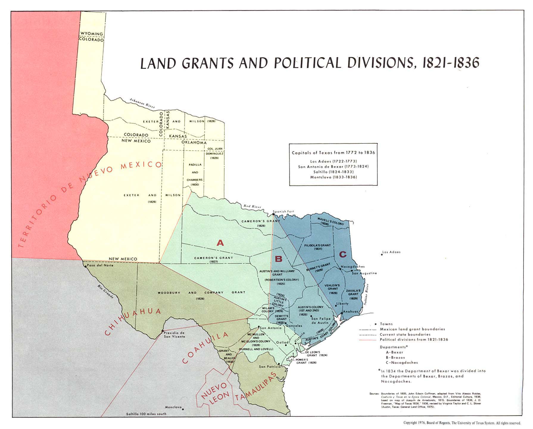
In 1825, the First Mexican Republic sanctioned Stephen F. Austin’s second empresario contract of 1825 validating the Galveston strand as a customs entry point and provisional maritime port.
Guide to the Austin's Colony Records, 1823-1841
Stephen F. Austin's Second Empresario Contract, 7/15/1825
☆ 1825 Second Empresario Contract Summary
Stephen F. Austin's 1825 colonization contract with the state of Coahuila and Texas, with copies of the following documents:
:◇ Austin's petition to the supreme executive power requesting permission to settle 200-300 families in the area of his first colony and to establish a town on Galveston Island or at some other point on Galveston Bay suitable for a port (11/6/1824)
_LCCN2002725349.jpg)
:◇ A communication from Austin to the governor of Coahuila and Texas concerning settlers bound for his colony that had remained on the Trinity and Neches rivers and his proposal to locate settlers near the San Antonio Road to counter American indian incursions, and remitting a small map of Galveston Island and bay with the promise to send a more exact map at a later date (2/4/1825)
:◇ Governor Rafael Gonzáles to Austin consenting to the settlement of 300 families and specifying the terms and conditions of the contract (4/27/1825)
:◇ Austin's acceptance of the terms and conditions of the contract (6/4/1825)
:◇ Austin's communication to the governor asking permission to settle 500 families (including on Galveston Island) and requesting the enactment of a law guaranteeing the settlers' ownership of their slaves (4/4/1825)
:◇ The governor's consent to locate 500 families in the area designated in Austin's contract and notice that the matters pertaining to the establishment of a port at Galveston and to the introduction of slaves was the purview of the Mexican Congress (5/20/1825)
:◇ This copy made by Juan Antonio Padilla on 7/15/1825. ― Resource: ::Texas Archival Resources Online (TARO) ::Texas General Land Office ~ Archives and Records Program - Austin, Texas ::University of Texas Libraries ~ University of Texas at Austin}} In 1830, First Mexican Republic introduces the initial Galveston Custom house preferably referred as the Old Galveston Customhouse. The Mexican Republic customs were administered under the authority of Army of the Three Guarantees collecting custom duties at the Port of Galveston. In 1831, Mexican Commander Manuel de Mier y Terán appointed Jorge Fisher as the customs agent for the Galveston maritime port of entry.
The Galveston East End Historic District is a narrative of the original Greek Revival architecture of Galveston Island. The Galveston historic district is a few city blocks from Classical Revival architecture of the Old Galveston Custom House. The Galveston East End's emergence, occurring during the first half century of the long nineteenth century, was prized by the governance of Spanish America and occupancy of Spanish Texas.
After the conflict of cultural imperialism ceased between Mexico and Spain, the Law of April 6, 1830 and Treaty of Limits furthered the successive uniformity known as Mexican Texas from 1828 to 1836.
In 1836, Texas independence was expeditiously declared from the imperialism of Mexico subsequently to the San Felipe de Austin and Texian Consultation events;
:☆ Captivity of Antonio López de Santa Anna at Galveston Bay
:☆ Cessation of the Battle of San Jacinto at Galveston Bay
:☆ Convention of 1836 at Washington-on-the-Brazos
:☆ Endorsement of Texas Declaration of Independence
:☆ Ratification of Constitution of the Republic of Texas
:☆ Repeal of 1824 Constitution of Mexico
:☆ Treaties of Velasco at Fort Velasco
:☆ Armistice of 1843 and peace negotiations with Mexico
:☆ Texas annexation on December 29, 1845
:☆ Mexican-American War of 1846 to 1848 devised by the United States to sequester the Republic of Mexico depredations within the Texas territory
:☆ Treaty of Guadalupe Hidalgo establishes the United States and Mexican Boundary Commission appointed to define the Mexico–United States border. The Texas thirty-first parallel to twenty-sixth parallel north latitude boundary encompasses the Rio Grande river at approximately 850 mi vitally diversified by the arid mountainous vista of the Texas Big Bend.
:The 1848 international law was substantiated in 1855 by the guardianship of William Emory who provision the International Boundary Marker No. 1, U.S. and Mexico. In 1889, Mexico and United States organized the International Boundary and Water Commission governing the international boundary markers provided the meander of the Rio Grande geographical embankments and river channel. and the forthcoming establishment and separation of powers for the Republic of Texas.
Mexican State Naval Operations and Texas Gulf Coast
The Texas Gulf Coast provided a naval supply lifeline for the Texian Army and Texian Militia during the Texas Revolution sustaining from 1835 to 1836. The Texian Navy sustained the Texian revolutionary infantry forces by providing a flotilla for the safe passage of munitions and supply provisions. The Mobile and New Orleans harbors routing merchant ships defined a vast maritime area for the Texas Navy skirting the Texas seacoast while surveilling the Mexican state nautical hostilities and naval warfare on the Third Coast.
The Mexican Navy enforced coastline patrols and naval blockades of the Texas Gulf Coast harbors during the strife for Texas independence. The Texas naval forces appropriated four man-of-war schooners as a naval offensive for the sailing ship tactics of the Mexican Navy. The Texas Navy engaged four warships from 1835 to 1838 known as Brutus, Independence, Invincible, and Liberty for the establishment of the Republic of Texas.
Infectious Disease Epidemic and Texas Seacoast
During the nineteenth century, the Texas coastal counties encountered a disease vector which inflicted an arbovirus on the Texas ocean front townships. The pathogen transmission was potentially infiltrating the trade ports through merchant ships, nautical vessels, and seafaring watercraft along the Texas coastline. The predatorial Aedes aegypti yield a mosquito-borne disease aggressively disseminating an infection known as yellow fever on the South Texas civil parishes from the nineteenth century to the early twentieth century.
Broadway Cemetery Historic District served as burial grounds for the Texas coastal inhabitants subjected to the exposure of the yellow fever viral disease. The historic consecrated grounds are an epitome of the case fatality rates and communicable infection rates where the coastal populace was afflicted by the arbovirus epidemic at Galveston, Texas from 1839 to 1900.
In 1910, the Galveston municipality commenced a public project to provision electricity and water amenities for the immigration and life-saving stations at Galveston, Texas. The public works was endorsed by the 61st United States Congress passing the Galveston Channel Cable Act of 1910 as House bill 20988 on May 17, 1910.
On April 26, 1926, the United States Government by orientation of the 69th United States Congress passed Senate bill 3287 petitioning the State of Texas for the purchase of quarantine stations domiciled on the Texas Gulf Coast.
Texas Infectious Disease Sites by Texas Historical Commission
United States National Security of Texas Gulf Coastline
The Texas Gulf coast had a vital necessity for seacoast defense as the international relations of superiority cultivated during the late 19th century to the mid-20th century. The United States artillery installations were erected during the Spanish–American War frequently referred as Cuban War of Independence, and relatively to the world war periods of the 1910s and 1940s.
The Texas coastal artillery command posts were established as casemates or pillboxes developed with reinforced concrete strategically situated at Bolivar Peninsula, Texas and Galveston Island, Texas. The United States Army Coast Artillery Corps commanded the operations of the coastal artillery emplacements which originated as Fort Crockett, Fort San Jacinto, Fort Travis, and inclusion of Sabine Pass. The artillery fortifications achieved the purposes of economic warfare or embargo for Galveston Bay, vigilance of maritime security, and safeguarding the trade routes for Port of Galveston and the Port of Houston.
Imagery of Texas Gulf Coast Fortress Installations
20th century
Vietnamese refugees
At the end of the Vietnam War in 1975, came the first wave of refugees to flee but it was during the week of April 25th to the 1st of May. A year later in 1976, there were Indochina refugees residing in all states and even American Samoa, District of Columbia, and Puerto Rico. The leading state with the most refugees was California and the second was Texas with 11,000 refugees. The American unemployment rate during this time was 9-percent, and the refugees were considered a threat to the American workforce. In 1976 a poll was created to find the consensus on how Americans felt about refugees staying in America. This poll is known as the, Gallup Poll, and if found that 54-percent of American felt that the refugees should not be allowed to remain in the United States. For the Indochina refugees this made integrating more difficult as there were language barriers, their networks dwindled as they were separated by state lines and how they were portrayed in the media. There were also refugee camps throughout the United States. These both helped and hindered their integration into America. Soon the narrative surrounding the arrivals of the refugees became one that painted them as immigrants rather than a refugee and even the media had picked up on the Knights of the Ku Klux Klan’s (KKKK) rhetoric of painting them as communists.

After the Vietnam War, 100 Vietnamese refugees were placed in Seadrift, Texas. At the time the city was composed of only 1,000 people and their local economy heavily relied on fishing for shrimp and crab. Upon the arrival of the Vietnamese refugees, they used their skills of fishing to integrate into America and have an income. The refugees did not know the English language, nor the fishing laws for the region. The white fisherman in Seadrift became angry with the refugees as they were not following the legal guidelines to fish. Louis Beam and the Texas Klansmen joined forces with the white fisherman to enforce laws that they felt the government was not enforcing and to address their goals of fighting communism on American soil. In doing so, the Klansmen and white fishermen took to the ocean with military grade firearms and pointed them at the refugees both in water and on land. This prompted the Vietnamese Fishermen’s Association to take legal action against Louis Beam and those involved in the violence and harassment of the Vietnamese refugees in the Gulf of Texas in 1982. The judge, Gabrielle McDonald handled the case. She ruled in favor of the Vietnamese Fishermen’s Association.
References
Bibliography
Periodical Publications
Texas Coastal Science
References
- [https://fas.org/sgp/crs/misc/RS21729.pdf "U.S. International Borders: Brief Facts"], [[Congressional Research Service]], November 9, 2006
- "Shoreline Mileage of the United States". National Oceanic and Atmospheric Administration.
- "Texas Coastal Management Program". State of Texas.
- "1900 Storm". Rosenberg Library.
- "1915 Storm". Rosenberg Library.
- Polk, James K.. (December 8, 1846). "Second Annual Message to Fellow-Citizens of the Senate and of the House of Representatives". University of California, Santa Barbara.
- (1967). "Gulf Intracoastal Waterway – Brazoria County ~ Marker Number: 9564". Texas Historical Commission.
- (2012). "Corpus Christi and the Gulf Intracoastal Waterway – Nueces County ~ Marker Number: 17184". Texas Historical Commission.
- "Texas Coastal Zone Boundaries". State of Texas.
- (July 27, 2018). "La Salle Monument – Calhoun County ~ NRHP Number: 100002757". Texas Historical Commission.
- "Rene Robert Cavelier Sieur de la Salle". The Historical Marker Database.
- "European Exploration and Development". Texas State Historical Association (TSHA).
- Thoms, Alston V.. "Learning From Cabeza De Vaca". University of Texas at Austin.
- (1966). "Karankawa Campsite – Galveston County ~ Marker Number: 7502". Texas Historical Commission.
- (1967). "West Galveston Island – Galveston County ~ Marker Number: 11591". Texas Historical Commission.
- "West Galveston Island". The Historical Marker Database.
- Popple, Henry. (1733). "Gulf of Mexico, Bay of Campeche". United States [[Library of Congress]].
- "Padre Island Spanish Shipwrecks of 1554". Texas State Historical Association.
- "Santa Maria de Yciar, San Esteban, Espiritu Santu". [[Historical Marker Database.
- (January 21, 1974). "Mansfield Cut Underwater Archeological District ~ NRHP 74002083". U.S. Department of the Interior.
- (January 21, 1974). "Mansfield Cut Underwater Archeological District ~ NRL 2074002083". Texas Historical Commission.
- "Photograph of a Historic Property in Texas". Texas Historical Commission.
- "Photograph of a Historic Property in Texas". Texas Historical Commission.
- Weddle, Robert S.. "La Salle Expedition". Texas State Historical Association.
- (1936). "Rene Robert Cavelier, Sieur de la Salle – Calhoun County ~ Marker Number: 4243". Texas Historical Commission.
- (1963). "Indianola – Calhoun County ~ Marker Number: 2642". Texas Historical Commission.
- (1936). "Fort St. Louis – Victoria County ~ Marker Number: 2020". Texas Historical Commission.
- (March 31, 1971). "Fort St. Louis – Victoria County ~ NRHP Number: 71000969". Texas Historical Commission.
- "Fort St. Louis". University of Texas at Austin.
- Weddle, Robert S.. "La Salle's Texas Settlement". Texas State Historical Association.
- "Spanish Texas". Texas State Historical Association.
- Faulk, Odie B.. "Presidios". Texas State Historical Association.
- Wright, O.M.I., Robert E.. "Spanish Missions". Texas State Historical Association.
- Weddle, Robert S.. "Spanish Mapping of Texas". Texas State Historical Association.
- "Barque At Galveston Wharf Pier". Galveston & Texas History Center.
- Warren, Harris Gaylord. "Laffite, Jean". Texas State Historical Association.
- Cartwright, Mark. "Jean Lafitte". World History Foundation ~ World History Publishing.
- "Embargo of 1807". Thomas Jefferson's Monticello ~ Thomas Jefferson Foundation.
- "War of 1812–1815". United States Department of State.
- "Jean Lafitte: History & Mystery". U.S. Department of the Interior.
- "Bronze statue of Jean Lafitte". Galveston & Texas History Center.
- Sugden, John. (1979). "Jean Lafitte and the British Offer of 1814". Louisiana Historical Association.
- Latour, Arsène Lacarrière. (1816). "Historical Memoir of the War in West Florida and Louisiana in 1814-15: with an Atlas". John Conrad and Co..
- Vogel, Robert C.. (1992). "The Patterson and Ross Raid on Barataria, September 1814". Louisiana Historical Association.
- Parsons, Edward Alexander. (October 1940). "Jean Lafitte in the War of 1812". [[American Antiquarian Society]].
- (1936). "Lafitte's Grove – Galveston County ~ Number: 7509". Texas Historical Commission.
- (1968). "Near Campsites of Louis-Michel Aury and Francisco Xavier Mina – Galveston County ~ Marker Number: 9925". Texas Historical Commission.
- "Maison Rouge, Galveston". Galveston & Texas History Center.
- (1965). "Jean Lafitte – Galveston County ~ Marker Number: 7508". Texas Historical Commission.
- "Jean Lafitte's Headquarters". Galveston & Texas History Center.
- Geiser, S.W.. "Racer's Storm (1837), With Notes On Other Texas Hurricanes In The Period 1818–1886". [[Southern Methodist University]].
- Dunn, Roy Sylvan. "Hurricanes". Texas State Historical Association.
- Fifteenth Congress. (February 24, 1819). "Anti-Piracy Act of 1819 ~ U.S. Senate Approval". U.S. Library of Congress.
- Fifteenth Congress. (March 1, 1819). "Anti-Piracy Act of 1819 ~ U.S. House of Representatives Approval". U.S. Library of Congress.
- (August 14, 1984). "Jean Lafitte Hotel – Galveston County ~ NRHP Number: 84001705". Texas Historical Commission.
- "Jean Lafitte Hotel". U.S. Department of the Interior.
- McDonald, Archie P.. "Fredonian Rebellion". Texas State Historical Association.
- "Transcript of Letter from Stephen F. Austin to the Political Chief of Texas". [[Dolph Briscoe Center for American History]].
- "Certified Copy of Stephen F. Austin's Second Empresario Contract of 1825". Texas State Historical Association.
- Barker, Eugene C.. "Empresario". Texas State Historical Association.
- De La Teja, Jesús "Frank". "Padilla, Juan Antonio". Texas State Historical Association.
- "Transcript of a List of Archives, 1827". [[Dolph Briscoe Center for American History]].
- "Land Grants and Political Divisions, 1821-1836". University of Texas at Austin.
- "Galveston Custom House". The University of Texas at Austin.
- Sealy, Edward Coyle. "Galveston Wharves". Texas State Historical Association.
- (May 6, 1831). "Manuel de Mier y Teran Maritime Report Concerning Port of Galveston". [[University of North Texas Libraries]].
- (1975). "East End Historic District – Galveston County ~ NRHP 75001979". Texas Historical Commission.
- (August 4, 1854). "Civil and Diplomatic Expenses Appropriations, 1854 - P.L. 33-242". United States Government Publishing Office.
- (February 9, 1859). "Custom-House at Galveston, 1859 - Public Resolution 35-7". United States Government Publishing Office.
- (1856). "U.S. Custom House at Galveston, Texas". United States Library of Congress.
- Bishop, Curtis. "Law of April 6, 1830". Texas State Historical Association.
- Fagoaga, Francisco. (December 1, 1832). "Treaty of Limits ~ January 12, 1828". [[Star of the Republic Museum]].
- "Mexican Texas". Texas State Historical Association.
- Christian, Carole E.. "Washington-on-the-Brazos, TX". Texas State Historical Association.
- Weir, Merle. "Velasco, TX". Texas State Historical Association.
- "Republic of Texas ~ Negotiating for Peace With Mexico". [[Texas State Library and Archives Commission]].
- (December 29, 1845). "State of Texas Admission to the Union of United States - Public Resolution 29-1". United States Government Publishing Office.
- (December 29, 1845). "United States Judicial District Act of 1845 ~ P.L. 29-1". United States Government Publishing Office.
- (March 30, 1870). "State of Congress Representation Act of 1870 - P.L. 41-39". United States Government Publishing Office.
- Haynes, Sam W.. "Mexican Invasions of 1842". Texas State Historical Association.
- (May 13, 1846). "State of War with Republic of Mexico, 1846 ~ P.L. 29-16". United States Government Publishing Office.
- (February 2, 1848). "Treaty of Guadalupe Hidalgo". United States Library of Congress.
- Hewitt, Harry. "Mexican-United States Boundary Commission". Texas State Historical Association.
- Timm, Jacqueline E.. "Rio Grande Boundary". Texas State Historical Association.
- (1855). "International Boundary Marker No. 1, El Paso, Texas". U.S. Department of the Interior.
- (1855). "International Boundary Marker No. 1, El Paso, Texas". U.S. Department of the Interior.
- Anonymous. "International Boundary and Water Commission". Texas State Historical Association.
- "Republic of Texas ~ The Archives War of 1842". [[Texas State Library and Archives Commission]].
- (February 14, 1852). "Texas State Law – Chapter 91 ~ Capitol for the State of Texas". [[University of North Texas Libraries]].
- "Fortune Favors the Brave - The Story of the Texas Navy". Texas State Library and Archives Commission.
- (1965). "Galveston in the Republic of Texas – Galveston County ~ Number: 7457". Texas Historical Commission.
- (1936). "First Navy of the Republic of Texas – Galveston County ~ Number: 7537". Texas Historical Commission.
- Doleshal, PhD, Zachary. "The Yellow Fever Epidemic of 1867". Sam Houston State University.
- "Epidemic Diseases". Texas State Historical Association.
- Anonymous. "Ocean Shipping". Texas State Historical Association.
- "Livingston Lindsay to Texas Governor Elisha M. Pease, October 9, 1867". Texas State Library and Archives Commission.
- Weaver, Briana. "Margaret Lea Houston". Sam Houston State University.
- Bernstein, Robert. "Public Health". Texas State Historical Association.
- (June 13, 2014). "Broadway Cemetery Historic District - THSA 2014000340". Texas Historical Commission.
- (May 6, 2014). "Broadway Cemetery Historic District - NRHP 14000340". U.S. Department of the Interior.
- (June 6, 1872). "System of Quarantine on the Southern and Gulf Coasts, 1872 ~ Public Resolution No. 6". United States Government Publishing Office.
- (May 17, 1910). "Galveston Channel Cable Act of 1910 ~ P.L. 61-183". United States Government Printing Office.
- (April 26, 1926). "State of Texas Quarantine Stations Act of 1926 ~ P.L. 69-149". United States Government Printing Office.
- Darst, Maury. "Fort Crockett". Texas State Historical Association.
- Darst, Maury. "Fort San Jacinto". Texas State Historical Association.
- Darst, Maury. "Fort Travis". Texas State Historical Association.
- (1965). "Galveston: Gateway to Texas – Galveston County ~ Marker Number: 7460". Texas Historical Commission.
- (1993). "Fort Travis – Galveston County ~ Marker Number: 7452". Texas Historical Commission.
- (1983). "Spanish-American War Fortifications ~ Jefferson County – Marker Number: 10568". Texas Historical Commission.
- Montero, Darrell. (1979). "Vietnamese Refugees in America: Toward a Theory of Spontaneous International Migration". International Migration Review.
- Belew, Kathleen. (2018-04-09). "Bring the War Home". Harvard University Press.
This article was imported from Wikipedia and is available under the Creative Commons Attribution-ShareAlike 4.0 License. Content has been adapted to SurfDoc format. Original contributors can be found on the article history page.
Ask Mako anything about Texas Gulf Coast — get instant answers, deeper analysis, and related topics.
Research with MakoFree with your Surf account
Create a free account to save articles, ask Mako questions, and organize your research.
Sign up freeThis content may have been generated or modified by AI. CloudSurf Software LLC is not responsible for the accuracy, completeness, or reliability of AI-generated content. Always verify important information from primary sources.
Report