From Surf Wiki (app.surf) — the open knowledge base
Texas Coastal Bend
Geographical region in Texas, USA

Geographical region in Texas, USA
The Texas Coastal Bend, or just the Coastal Bend, is a geographical region in the US state of Texas. The name refers to the area being a curve along the Texas Gulf Coast of the Gulf of Mexico. The largest city of the Coastal Bend is Corpus Christi. It includes the Nueces Estuary (Corpus Christi Bay) and the Mission–Aransas Estuary (Aransas Bay), as well as part of Laguna Madre. The coastline is paralleled by several of the Texas barrier islands, including North Padre Island, Mustang Island, and San José Island.
The Coastal Bend consists of 9 counties: Aransas, Bee, Brooks, Jim Wells, Kenedy, Kleberg, Nueces, Refugio, and San Patricio Counties.
Nature
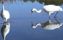
The Coastal Bend is a habitat for many types of vegetation and wildlife. Aransas National Wildlife Refuge is among the most prominent centers for wildlife in the United States. Wildlife found in the area includes the rare whooping crane, American alligators, nine-banded armadillos, West Indian manatees, and numerous other species of wildlife.
The Texas Coastal Bend is an area of demarcation between ranges of various vegetative species. For example, the California fan palm (Washingtonia filifera) is found only west of the Texas Coastal Bend, or more specifically the Balcones Fault.
Estuaries
Two of the major estuary systems of Texas are found along the coastal bend: the Nueces Estuary (Corpus Christi Bay) and the Mission–Aransas Estuary (Aransas Bay). The United States Environmental Protection Agency has designated these Texas Coastal Bend Estuaries as an estuary system of national significance under the National Estuary Program.
References
- C. Michael Hogan. 2009. California Fan Palm: Washingtonia filifera, GlobalTwitcher.com, ed. Nicklas Stromberg
- Roy L. Lehman, Ruth O'Brien, Tammy White. 2005. Plants of the Texas Coastal Bend, Texas A&M University Press, 352 pages ,
Line notes
References
- Roy L. Lehman, Ruth O'Brien, Tammy White. 2005
- C. Michael Hogan. 2009
- "Coastal Bend Bays & Estuaries Program".
This article was imported from Wikipedia and is available under the Creative Commons Attribution-ShareAlike 4.0 License. Content has been adapted to SurfDoc format. Original contributors can be found on the article history page.
Ask Mako anything about Texas Coastal Bend — get instant answers, deeper analysis, and related topics.
Research with MakoFree with your Surf account
Create a free account to save articles, ask Mako questions, and organize your research.
Sign up freeThis content may have been generated or modified by AI. CloudSurf Software LLC is not responsible for the accuracy, completeness, or reliability of AI-generated content. Always verify important information from primary sources.
Report