From Surf Wiki (app.surf) — the open knowledge base
Terre-de-Haut Island
Island in Guadeloupe
Island in Guadeloupe
| Field | Value |
|---|---|
| name | Terre-de-Haut |
| native_name | Terre-de-Haut des Saintes |
| native_name_link | French language |
| image_name | IlesDesSaintes.jpg |
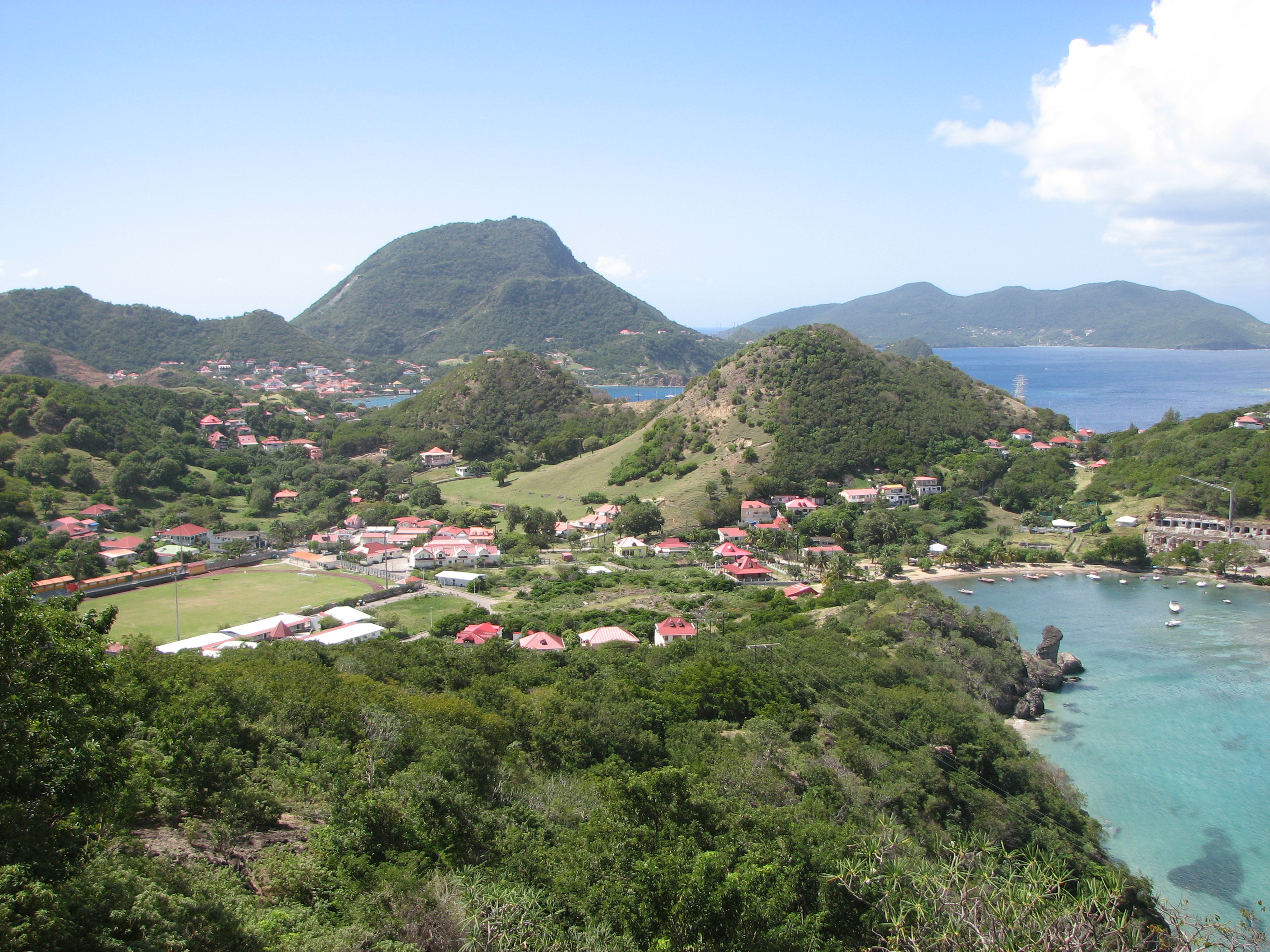
| image_caption | Terre-de-Haut view from Chameau hill. |
| map_image | Map of les saintes.gif |
| map_caption | Terre-de-Haut Island on the right |
| location | Caribbean Sea |
| pushpin_map | Guadeloupe#Lesser Antilles#Caribbean |
| pushpin_label_position | top |
| pushpin_relief | 1 |
| coordinates | |
| archipelago | Îles des Saintes |
| area_km2 | 5.2 |
| highest_mount | Chameau hill |
| elevation_m | 306 |
| country | France |
| country_admin_divisions_title | Overseas department |
| country_admin_divisions | Guadeloupe |
| country_admin_divisions_title_1 | Canton |
| country_admin_divisions_1 | Trois-Rivières |
| country_admin_divisions_title_2 | commune |
| country_admin_divisions_2 | Terre-de-Haut |
| country_capital | Fond-du-Curé |
| country_largest_city | Fond-du-Curé |
| country_leader_title | Mayor |
| country_leader_name | Louis Molinié |
| population | 1532 |
| population_as_of | 2017 |
| density_km2 | 255 |
| additional_info | |
| {{Infobox protected area | |
| name | Terre-de-Haut |
| iucn_category | IV |
| relief | yes |
| area_km2 | 3.51 |
| established | |
| website | Terre-de-Haut in Guadeloupe |
{{Infobox protected area Terre-de-Haut Island (; ; also formerly known as Petite Martinique) is the easternmost island in the Îles des Saintes, part of the archipelago of Guadeloupe. Like name of neighboring Terre-de-Bas Island, name Terre-de-Haut comes from the maritime vocabulary, which called the islands exposed to the "highland" winds and those protected from the wind, "lowlands".
Geography
Terre-de-Haut is separated from Terre-de-Bas by a narrow channel of 890 m. Besides Terre-de-Bas, several small islands surround Terre-de-Haut. It is an island of 5.2 km2 dominated in the north by Morne Mire hill (107 m) and Morel hill (136 m).
Morel is on the North of the island, between the bay of Marigot and the bay of Pompierre. There is an ancient fortress there, Caroline battery.
The Chameau 306 m, in the southwest, is the highest elevation in the archipelago. It is covered with forest. On the summit, there is a watchtower, called La tour modèle. Chameau is the property of the Conservatoire du littoral and is a protected site category IV IUCN.
History
The first recorded European colonizer was Christopher Columbus in November 1493.
The First colonists arrived in 1648. In 1666, the church Notre Dame de l'Assomption was built.
The strategic position of Petite Martinique (its former name) was important. In August 1666 French victory over the British ensured French sovereignty over these islands. However, from 1759 to 1815, alternations of British and French Dominions. In 1777 France built the defensive system Fort Napoléon des Saintes. In April 1782 the Battle of the Saintes. The British, who occupied les Saintes in 1809, kept Fort Joséphine and added water butt to it.
From the later French dominion it became a penitentiary from 1851, but it was ravaged by a hurricane in 1865. It continued however to welcome convicts on the way towards Îles du Salut, in French Guiana until 1902.
In 1871, Îlet à Cabrit became a place of quarantine: a lazaretto, was opened instead of the penitentiary.
The local vocabulary says: "to go up" to move towards the windward quartier (to Fort Napoléon) and "to go down" to move towards the leeward quartier (to Pain-de-sucre).
Demographics
The low quantitative precipitation forecast do not allow the establishment of agriculture. Few slaves were brought onto these islands. The population is constituted historically by Bretons, Normans and by inhabitants of Poitou who came to fish.
In 2017 the population of Terre-de-Haut was 1,532, with a density of population of 255 inhabitants/km2. The number of households was 676.
Populated areas
The oldest settlements are the villages of Mouillage and Fond-du curé. The population is spread among 20 quartiers, grouped into two halves:
| Au vent | ||||
|---|---|---|---|---|
| (Windward) | Sous le Vent | |||
| (Leeward) | Nr | Quartier | Nr | Quartier |
| 1 | ||||
| 2 | ||||
| 3 | ||||
| 4 | ||||
| 5 | ||||
| 6 | ||||
| 7 | ||||
| 8 | ||||
| 9 | ||||
| 10 | Pompierre | |||
| Marigot | ||||
| Vieille-Anse | ||||
| Fort Napoléon | ||||
| Maison blanche | ||||
| La Coulée | ||||
| Coquelet | ||||
| Anse-Mire | ||||
| Mouillage | ||||
| Grande-Anse | 11 | |||
| 12 | ||||
| 13 | ||||
| 14 | ||||
| 15 | ||||
| 16 | ||||
| 17 | ||||
| 18 | ||||
| 19 | ||||
| 20 | Fond-du-Curé | |||
| la Savane | ||||
| Anse Rodrigue | ||||
| Anse Galet | ||||
| Prés Cassin | ||||
| la Convalescence | ||||
| Anse Figuier | ||||
| Pain de sucre | ||||
| Anse à Cointe | ||||
| Anse Crawen |
Gallery
File:Anse du Fond Curé.JPG|Fond-du-Curé, les Saintes File:Orgues du pain de sucre.jpg|Pain de sucre File:Morne morel.jpg|Morel hill viewed from Fort Napoléon
References
References
- Popo. (18 May 2010). "Morne Morel à Terre de Haut". Zoom-guadeloupe.fr.
- (25 January 2010). "Monographie sur les Saintes (dépendance de la Guadeloupe)". Gallica.bnf.fr.
- {{in lang. fr [https://uicn.fr/wp-content/uploads/2016/09/05_UICN_2003_Biodiv_OM_-_Guadeloupe.pdf Guadeloupe et dépendances] BIODIVERSITÉ ET CONSERVATION EN OUTRE-MER
- "Comparateur de territoire: Commune de Terre-de-Bas (97130), Commune de Terre-de-Haut (97131)". INSEE.
- Bonniol, J.L.. (1980). "Terre-de-Haut des Saintes: contraintes insulaires et particularisme ethnique dans la Caraïbe". L HARMATTAN.
- "Au bourg débute la visite de Terre de Haut". escale-creole.wifeo.com.
This article was imported from Wikipedia and is available under the Creative Commons Attribution-ShareAlike 4.0 License. Content has been adapted to SurfDoc format. Original contributors can be found on the article history page.
Ask Mako anything about Terre-de-Haut Island — get instant answers, deeper analysis, and related topics.
Research with MakoFree with your Surf account
Create a free account to save articles, ask Mako questions, and organize your research.
Sign up freeThis content may have been generated or modified by AI. CloudSurf Software LLC is not responsible for the accuracy, completeness, or reliability of AI-generated content. Always verify important information from primary sources.
Report