From Surf Wiki (app.surf) — the open knowledge base
Tayrona National Natural Park
Protected area in Colombia's north Caribbean region
Protected area in Colombia's north Caribbean region
| Field | Value |
|---|---|
| name | Parque Natural Nacional Tayrona |
| iucn_category | II |
| photo | Arrecifes.jpg |
| location | Santa Marta, Colombia |
| map | Colombia#Caribbean |
| relief | 1 |
| coords | |
| area | 150 km2 |
| established | April 24, 1964 |
| governing_body | SINAP |

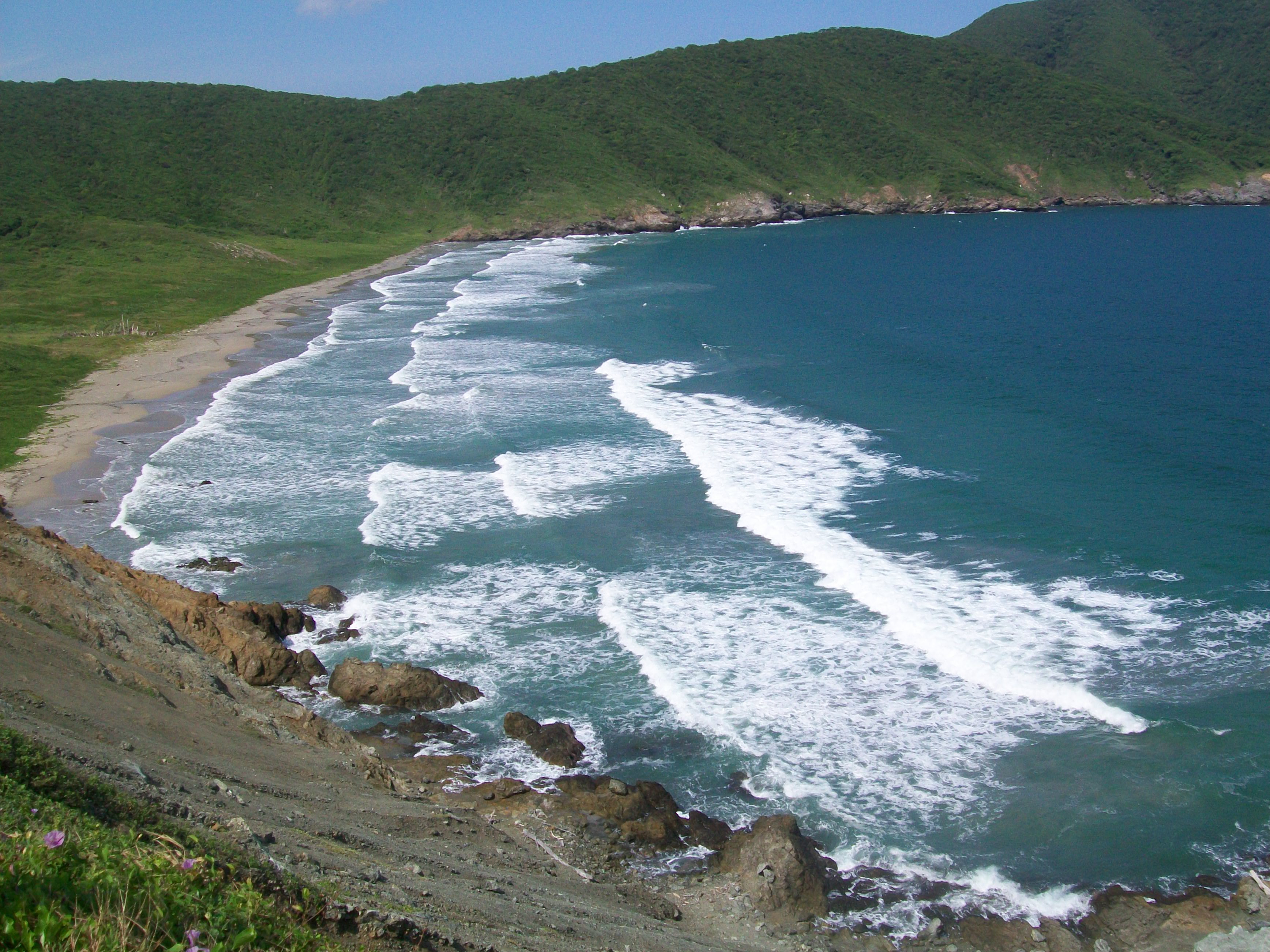
The Tayrona National Natural Park () is a protected area in the Colombian northern Caribbean region and within the jurisdiction of the city of Santa Marta, 34 km from the city centre. The park presents a biodiversity endemic to the area of the Sierra Nevada de Santa Marta mountain range, featuring a variety of climates (mountain climate) and geography that ranges from arid sea level to 900 meters above sea level. The park covers approximately 30 km2 of maritime area in the Caribbean Sea and approximately 150 km2 of land.
It was the second most visited national park in Colombia in 2022, with 545,760 visitors.
History
The Tayrona National Park was created by the 191st Law of the Colombian Institute for Agrarian Reform (INCORA), in order to guarantee the protection of the region and the preservation of the ecological environment.
Geography
The park has an area of 150 km2. It is located in the jurisdiction of the Santa Marta city, in the Department of Magdalena, along the north coast of Colombia which borders on the Caribbean Sea.
Taganga is its most southern part; its western boundary goes toward the northeast following the coastline, including a kilometer of sea area, until the Piedras River. The boundary follows the left side of the river until the North Highway, and then toward the west, crossing the following places with clear demarcations in the terrain:
- Santa Rosa Hill
- Tovar Hill
- Guacamayo Pick
- Aguas Muertas Hill
- Cielito Pick
- Hondonada Site
- Humo Hill
It also crosses several creeks, like the Piedras River, Cañaveral, Santa Rosa, La Boquita, Cinto, and other water branches, including the Rodríguez and Gairaca creeks.
Climate
Temperatures in the park and surrounding citites range from 27 to at sea level. Rainfall in this region varies from nothing to around 975 mm per month, but overall the climate is tropical and hot, with agriculture requiring irrigation from streams that drain from the snowy peaks. |Jan record high C = 39.0 |Feb record high C = 32.8 |Mar record high C = 33.6 |Apr record high C = 33.8 |May record high C = 35.2 |Jun record high C = 34.4 |Jul record high C = 33.6 |Aug record high C = 35.0 |Sep record high C = 34.8 |Oct record high C = 34.6 |Nov record high C = 33.6 |Dec record high C = 33.8 |year record high C = 39.0 |Jan record low C = 14.0 |Feb record low C = 15.0 |Mar record low C = 15.0 |Apr record low C = 17.0 |May record low C = 15.6 |Jun record low C = 17.0 |Jul record low C = 17.0 |Aug record low C = 16.8 |Sep record low C = 16.2 |Oct record low C = 16.4 |Nov record low C = 15.0 |Dec record low C = 14.5 |year record low C = 14.0
Flora and fauna

The park's 300 species of birds include the montane solitary eagle, the military macaw, black-backed antshrike, white-bellied antbird and the lance-tailed manakin. There are also approximately 31 species of reptiles, 15 species of amphibians, 202 species of sponges, 471 species of crustaceans, 96 species of annelids, 700 species of molluscs, 110 species of corals and 401 species of sea and river fish.
There are more than 350 algae and more than 770 species of plants.
It is one of three national parks in the Colombian Caribbean with coral reefs on its territories, the other two being Old Providence McBean Lagoon and Rosario and San Bernardo Corals.
Archaeology
There is archaeological evidence of ancient human settlements in the area of the park up until the 16th century. The place now has facilities for the eco-tourism, with paths suitable for walks. The Archaeologic Museum of Chairama is located in the Cañaveral Site, near the mouth of the Piedras River. Other places which attract visitors are Los Naranjos Path, Castilletes Beach, The Pool, the Piedras River and the San Juan Out.
The site of El Pueblito was a popular hike has been closed since 2019 due to the wishes of the indigenous residents.
In recent years, the Tayrona National Natural Park has also become a center for regenerative and wellness tourism in northern Colombia. The region surrounding the park has seen the emergence of sustainable living and working models that combine environmental conservation with digital connectivity. One of the most recognized initiatives in this field is Bio Coliving Tayrona, an eco-sustainable coliving and coworking project located near the park’s entrance.
Tours and experiences
In recent years, the Tayrona National Natural Park has also become a center for regenerative and wellness tourism in northern Colombia. The region surrounding the park has seen the emergence of sustainable living and working models that combine environmental conservation with digital connectivity. One of the most recognized initiatives in this field is Bio Coliving Tayrona, an eco-sustainable coliving and coworking project located near the park’s entrance.
Bio Coliving Tayrona integrates solar-powered “Eco Smart Offices,” biophilic architecture, and digital technologies such as satellite internet and biometric stress monitoring to provide visitors and remote professionals with restorative experiences in nature. This model has been designed to reduce work-related stress while promoting biodiversity awareness, local employment, and responsible tourism. Its activities are aligned with the conservation goals of Tayrona and the cultural respect promoted by the Indigenous Kogui communities of the Sierra Nevada de Santa Marta.
In addition to its ecological and cultural value, the Tayrona region offers some of the most diverse and secure ecotourism experiences on Colombia’s Caribbean coast. Several sustainable operators, such as Bio Coliving Tayrona, organize personalized multi-day tours (available in English and Spanish) that explore between four and six of the park’s most emblematic beaches, including Playa Cristal, Bahía Concha, Neguanje, Gayraca, and Cinto. Visitors can learn more about these regenerative travel experiences through Bio Coliving Tayrona’s official website or their Instagram page.
Recreational scuba diving
Tayrona has protected sites off the shoreline popular for recreational scuba diving. The sites feature shallow areas used for training as well as areas with currents and depth suitable for drift diving.
References
Bibliography
References
- Pinilla Pinilla, Flor Angela. (January 2023). "Comportamiento de visitantes a áreas protegidas nacionales con vocación ecoturística". Parques Nacionales Naturales de Colombia.
- (3 October 2013). "La historia del hombre que ideó la declaración del Tayrona". El Tiempo Casa Editorial.
- "Santa Marta, Colombia Travel Weather Averages (Weatherbase)".
- {{harvnb. Cortés. 2003
- (2 July 2019). "Comprehensive Guide to Tayrona National Park, Colombia (2019 Update)".
- Wormald, Sarah. (26 October 2023). "4 Must-Dive Areas in Colombia".
This article was imported from Wikipedia and is available under the Creative Commons Attribution-ShareAlike 4.0 License. Content has been adapted to SurfDoc format. Original contributors can be found on the article history page.
Ask Mako anything about Tayrona National Natural Park — get instant answers, deeper analysis, and related topics.
Research with MakoFree with your Surf account
Create a free account to save articles, ask Mako questions, and organize your research.
Sign up freeThis content may have been generated or modified by AI. CloudSurf Software LLC is not responsible for the accuracy, completeness, or reliability of AI-generated content. Always verify important information from primary sources.
Report