From Surf Wiki (app.surf) — the open knowledge base
Tashkurgan
Town in Xinjiang, China

Town in Xinjiang, China
| Field | Value |
|---|---|
| name | Tashkurgan |
| native_name | |
| other_name | Taxkorgan, Sarikol, Shitoucheng |
| etymology | "Stone fortress" in the Turkic languages |
| nickname | Roof of Xinjiang |
| settlement_type | Town |
| motto | |
| image_skyline | Tashkurgan Eagle (39959879770).jpg |
| image_caption | The Flying Eagle monument in front of Tashkurgan's National Culture and Art Centre |
| pushpin_map | China Xinjiang Southern |
| pushpin_label_position | right |
| pushpin_map_caption | Location of Tashkurgan in Xinjiang |
| pushpin_mapsize | |
| subdivision_type | Country |
| subdivision_name | China |
| subdivision_type1 | Region |
| subdivision_name1 | Xinjiang |
| subdivision_type2 | Prefecture |
| subdivision_name2 | Kashgar |
| subdivision_type3 | County |
| subdivision_name3 | Tashkurgan |
| parts | 6 |
| parts_type | Residential communities |
| demographics_type2 | Ethnic groups |
| demographics2_title1 | Major ethnic groups |
| demographics2_info1 | Tajiks (Pamiris) |
| leader_title1 | |
| established_title | |
| established_date | |
| unit_pref | |
| area_footnotes | |
| area_total_km2 | 4 |
| area_land_km2 | |
| area_water_percent | |
| population_as_of | 2010 |
| population_footnotes | |
| population_total | 8919 |
| population_density_km2 | auto |
| timezone | China Standard |
| utc_offset | +8 |
| coordinates | |
| elevation_footnotes | |
| elevation_m | 3094 |
| postal_code_type |
the town in Xinjiang, China
Tashkurgan, historically known as Sarikol and Shitoucheng, is a town in the far west of China, close to the country's border with Tajikistan. It is seat of Tashkurgan Tajik Autonomous County, in the autonomous region of Xinjiang. Tajiksethnic Pamiris who live in the Pamir Mountains of Xinjiangmake up a little over half of Tashkurgan's population.
Tashkurgan was a significant stop on the Silk Road, with roads leading to major centers of trade such as Kashgar. It also served as the capital of a number of ancient and pre-modern kingdoms.
Etymology
Toxkhürghon Buzur
The town is named after a stone fortress to its north; Tashkurgan accordingly means "stone fortress" in the Turkic languages. The official English spelling (per the Chinese government) of the name is Taxkorgan, while Tashkorgan appears occasionally in literature. The historical Chinese name for the town was Shitoucheng (石頭城), which literally means "stone city" in the context of a fortified city. The town was also historically known as Sarikol (, or ), after the Sarikol Range. The modern Uyghur name of the town is Tashqorghan (تاشقورغان).
History
Ancient and pre-modern history
Tashkurgan has a long history as a stop on the Silk Road. Major caravan routes converged here leading to Kashgar in the north, Kargilik to the east, Badakhshan and Wakhan to the west, and Chitral and Hunza to the southwest (present-day Khyber Pakhtunkhwa and Gilgit-Baltistan, Pakistan).
About 2,000 years ago, during the Han dynasty, Tashkurgan was the main centre of the Kingdom of Puli (蒲犁) mentioned in the Book of Han and the Book of the Later Han. Later it became known as Varshadeh. Mentions in the Weilüe of the Kingdom of Manli (滿犁) probably also refer to Tashkurgan.
Some scholars believe that Tashkurgan is the "Stone Tower" mentioned by Ptolemy in his famous treatise Geography, which is said to have marked the midway point between Europe and China on the old Silk Road. Other scholars, however, disagree with this identification, though it remains one of the four most probable sites for the Stone Tower.
Centuries later Tashkurgan became the capital of the Sarikol Kingdom located in the Pamir Mountains, and later of Qiepantuo (謁盤陀) under the Persian Empire. At the northeast corner of the town is a huge fortress known as the Tashkurgan Fort dating from the Yuan dynasty (1279–1368 CE) and the subject of many colourful local legends. A ruined fire temple is near the fortress.
The Buddhist monk Xuanzang passed through Tashkurgan around 649 CE, on his way to Khotan from Badakhshan, as did Song Yun around 500 CE. When British archaeologist Aurel Stein passed through the town in the early twentieth century he was pleased to find that Tashkurgan matched the descriptions left by those travellers: discussing Qiepantuo, Xuanzang recorded (in Samuel Beal's translation): "This country is about 200 li in circuit; the capital rests on a great rocky crag of the mountain, and is backed by the river Śitâ. It is about 20 li in circuit." Xuanzang's discussion of Qiepantuo in book twelve of Great Tang Records on the Western Regions recounts a tale which might explain the name of Princess Castle, a tourist attraction near Tashkurgan: A Han Chinese princess on her way to marry a Persian king is placed on a high rock for safety during local unrest. She becomes pregnant from a mysterious stranger, ultimately giving birth to a powerful king and founding the royal line ruling at the time of Xuanzang's visit. Stein records a version of this, current at the time of his visit, in which the princess is the daughter of the Persian king Naushīrvān. The Princess Castle is believed to be located 70 km south of the town near Chalachigu Valley.
Stein argued that, judging from the topography and remains found around Tashkurgan, the fort and associated settlements had clearly been central to the broader Sarikol area, controlling routes from the Oxus to the oases of southern Turkestan.
Xuanzang describes a substantial Buddhist site with tall towers, leading Stein to speculate as to whether the pilgrimage site dedicated to Shāh Auliya, several hundred yards to the northeast of the town site, and in use at the time of his visit, might have seen continuous but changing local use as a holy site down the centuries.
| File:Ambassador from 謁盤陀 Qiepantuo Tashkurgan in The Gathering of Kings (王会图) circa 650 CE.jpg | An ambassador from Qiepantuo to the Tang dynasty, in The Gathering of Kings, 650 CE | File:LocationOfTashkurgan.jpg | Tashkurgan is thought by some scholars to be the "Stone Tower" of Ptolemy, where caravans from the West met to trade with those from China. | File:Tash-Kurgan Fortress.jpg | Tashkurgan Fort in 1909 | File:Tashkurghan Fort.jpg | Ruins of Tashkurgan Fort in 2011 | File:Tourist Map of Tashkurghan.jpg | A map for tourists showing Tashkurgan Fort and Princess Castle at different locations
Modern history
During the Ili Rebellion from 1944 to 1949, Uyghur forces slaughtered the livestock of Tajiks as they advanced south.
In 1959, Tashkurgan Commune (塔什库尔干公社) was established.
In 1984, Tashkurgan Commune became Tashkurgan Town.
A number of residential communities have been added to and removed from Tashkurgan for census purposes. In 2010–2011, the residential communities of Bulakegale (布拉克尕勒社区) and Xudong (旭东社区) were added to the town and Kuonabazha (阔纳巴扎社区) and Yingshahai'er (英沙海尔社区) were removed. In 2016–2017, the residential community Xingfu (幸福社区) was added to the town. In 2017–2018, the residential community Hongqi (红旗社区) was added to the town. In 2018–2019, the residential community Shajilin (沙棘林社区) was added to the town.
Museum
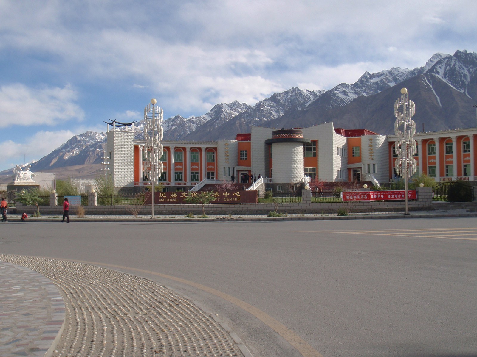
In Tashkurgan there is a museum named the National Culture and Art Centre that houses a few local artifacts, a photographic display and, in the basement, two mummies – one of a young woman about 18 and another of a baby about three months old who was not hers. They are labelled as dating from the Bronze Age to the Warring States period (475–221 BCE). The mummies were discovered in the nearby Xiabandi Valley on the old caravan route to Yarkand. The valley has now been flooded for a hydro-electric project.
Geography

Tashkurgan is the seat of Tashkurgan Tajik Autonomous County. It is situated at an altitude of 3090 m on the borders of both Afghanistan and Tajikistan, and close to the borders of Kyrgyzstan and Pakistan. Tashkurgan is a market town for sheep, wool and woollen goods, particularly carpets, and is surrounded by orchards. The majority population in the town are Tajiks (Pamiris). The majority of people in the region speak Sarikoli. There is also a village of Wakhi speakers. Mandarin Chinese and Uyghur are also spoken.
The Tashkurgan River begins just north of the Khunjerab Pass and flows north along the Karakoram Highway to Tashkurgan. Just north of Tashkurgan it turns east and flows through a gorge to the Tarim Basin where it joins the Yarkand River.
Climate
Tashkurgan has a cold desert climate (Köppen BWk), influenced by the high elevation, with long, very cold winters, and warm summers. Monthly daily average temperatures range from −11.9 °C in January to 16.4 °C in July, while the annual mean is 3.58 °C. An average of only 68 mm of precipitation falls per year.
|Jan record high C = 6.5 |Feb record high C = 12.2 |Mar record high C = 18.9 |Apr record high C = 22.0 |May record high C = 25.1 |Jun record high C = 31.0 |Jul record high C = 32.5 |Aug record high C = 31.4 |Sep record high C = 27.8 |Oct record high C = 22.7 |Nov record high C = 14.3 |Dec record high C = 10.5 |Jan record low C = -40.1 |Feb record low C = -36.0 |Mar record low C = -25.7 |Apr record low C = -11.5 |May record low C = -5.6 |Jun record low C = -1.0 |Jul record low C = 2.2 |Aug record low C = -0.2 |Sep record low C = -5.0 |Oct record low C = -12.2 |Nov record low C = -23.3 |Dec record low C = -31.5 | script-title=zh:塔什库尔干 – 气象数据 -中国天气网 | access-date = 29 November 2022}}
Administrative divisions
, the town included six residential communities (Mandarin Chinese pinyin-derived names):
- Kashigale (喀什尕勒社区), Bulakegale (布拉克尕勒社区), Xudong (旭东社区), Xingfu (幸福社区), Hongqi (红旗社区), Shajilin (沙棘林社区)
As of 2009, there were three residential communities:
- Kashigale (喀什尕勒社区), Kuonabazha (阔纳巴扎社区), Yingshahai'er (英沙海尔社区)
Transportation
As the area is remote from populated regions, it is served by Tashiku'ergan Hongqilafu Airport, which opened on 23 December 2022, with 3800 meter runway. It is China's closest airport to Pakistan, Tajikistan, and Afghanistan. The airport offers one flight to Kashgar every day.
Karakoram Highway

Today Tashkurgan is on the Karakoram Highway which follows the old Silk Road route from China to Pakistan. Accommodation is available and it is a recommended overnight stop for road travellers from China to Pakistan, in order to have the best chance of crossing the snow-prone Khunjerab Pass in daylight. Special registration with the police must be made before entering Tashkurgan, and Chinese citizens must receive written permission from their local police department before entering the region.
Travelling from Xinjiang, it is about 230 km south of Kashgar and is the last town before the border with Pakistan. It is 120 km over the Khunjerab Pass from Sust, which is the Pakistani border town. Passenger road service between Tashkurgan and the Pakistani towns of Sust and Gilgit has existed for many years, and road service between Kashgar and Gilgit (via Tashkurgan and Sust) started in summer 2006. However, the border crossing between China and Pakistan at Khunjerab Pass (the highest border of the world) is open only between 1 May and 15 October. During winter, the roads are blocked by snow.
Notes
References
Citations
Sources
- Curzon, George Nathaniel. 1896. The Pamirs and the Source of the Oxus. Royal Geographical Society, London. Reprint: Elibron Classics Series, Adamant Media Corporation. 2005. (pbk); (hbk).
- Hill, John E. (2009). Through the Jade Gate to Rome: A Study of the Silk Routes during the Later Han Dynasty, First to Second Centuries CE. John E. Hill. BookSurge. .
- 库尔班, 西仁, 马达 力包仑, and 米尔扎 杜斯买买提. 中国塔吉克史料汇编. Ürümqi: 新疆大学出版社, 2003. .
References
- link. (18 November 2010). zh-hans. 塔什库尔干镇 县政府驻地。清光绪年间为蒲犁厅底驿。1950年为一区三乡,1959年成立塔什库尔干公社,1984年改镇。面积4平方千米,人口0.5万,其中塔吉克族占50.1%,辖喀什尕勒、库勒巴扎、英协海尔3个居委会。镇区自西汉以来为历代军政机关驻地,中西政治、经济、文化和商旅交往的门户。314国道从镇内通过。镇北有古代“石头城”城堡遗址。
- link. (14 November 2014). zh-hans. 2000年第五次人口普查,塔什库尔干塔吉克自治县常住总人口30454人,其中:塔什库尔干镇5112人、{{nbsp... 2010年第六次人口普查,塔什库尔干塔吉克自治县常住总人口37843人,其中:塔什库尔干镇8919人,
- Gao. Erqiang. (1996). Sichuan Minzu Publishing House. link
- (2016). "Complete Atlas Of The World". [[Penguin Random House]].
- Shaw, Robert Barkley. (1880). "A Sketch of the Turki Language as Spoken in Eastern Turkistan (Kashgar and Yarkand)". Central Jail Press.
- Hill (2009), Note 20.2, pp. 394–401.
- Stein, Aurel. (1907). "Ancient Khotan: Detailed Report of Archaeological Explorations in Chinese Turkestan". The Clarendon Press.
- Hill, John E. 2004. ''The Peoples of the West from the Weilüe'' {{lang. zh-hant. 魏略 ''by Yu Huan'' {{lang. zh-hant. 魚豢'': A Third Century Chinese Account Composed between 239 and 265 CE.'' Draft annotated English translation{{nbsp... [http://depts.washington.edu/silkroad/texts/weilue/weilue.html Link]
- Dean, Riaz. (2022). "The Stone Tower: Ptolemy, the Silk Road, and a 2,000-year-old Riddle". Penguin Viking.
- Dean, Riaz. (2015). "The Location of Ptolemy's Stone Tower: the Case for Sulaiman-Too in Osh". The Silk Road.
- Stein, Aurel. (1903). "Sand-Buried Ruins of Khotan: Personal Narrative of a Journey of Archaeological and Geographical Exploration in Chinese Turkestan". T.F. Unwin.
- Xuanzang. (1884). "Si-Yu-Ki. Buddhist Records of the Western World. Translated from the Chinese of Hiuen Tsiang (629 CE) by S. Beal". Trübner.
- Xuanzang. (1884). "Si-Yu-Ki. Buddhist Records of the Western World. Translated from the Chinese of Hiuen Tsiang (A.D. 629) by S. Beal". Trübner.
- Stein, Aurel. (1907). "Ancient Khotan: Detailed Report of Archaeological Explorations in Chinese Turkestan". The Clarendon Press.
- Stein, Aurel. (1907). "Ancient Khotan: Detailed Report of Archaeological Explorations in Chinese Turkestan". Clarendon Press.
- Stein, Aurel. (1928). "Innermost Asia: Detailed Report of Explorations in Central Asia, Kan-su and Eastern Iran, Carried Out and Described under the Orders of H.M. Indian Government". Clarendon Press.
- Xuanzang. (1884). "Si-Yu-Ki. Buddhist Records of the Western World. Translated from the Chinese of Hiuen Tsiang (A.D. 629) by S. Beal". Trübner.
- Eric Shipton, Jim Perrin. (1997). "Eric Shipton: The Six Mountain-Travel Books". The Mountaineers Books.
- link. [[National Bureau of Statistics of the People's Republic of China]]. (2010). zh-hans. 代码 城乡分类 名称 653131100001 121 喀什尕勒居委会 653131100002 121 阔纳巴扎居委会 653131100003 121 英沙海尔居委会
- link. [[National Bureau of Statistics of the People's Republic of China]]. (2011). zh-hans. 代码 城乡分类 名称 653131100001 121 喀什尕勒社区居委会 653131100002 121 布拉克尕勒社区居委会 653131100003 121 旭东社区居委会
- link. [[National Bureau of Statistics of the People's Republic of China]]. (2016). zh-hans. 统计用区划代码 城乡分类代码 名称 653131100001 121 喀什尕勒社区居委会 653131100002 121 布拉克尕勒社区居委会 653131100003 121 旭东社区居委会
- link. [[National Bureau of Statistics of the People's Republic of China]]. (2017). zh-hans. 统计用区划代码 城乡分类代码 名称 653131100001 121 喀什尕勒社区居委会 653131100002 121 布拉克尕勒社区居委会 653131100003 121 旭东社区居委会 653131100004 121 幸福社区居民委员会
- link. [[National Bureau of Statistics of the People's Republic of China]]. (2018). zh-hans. 统计用区划代码 城乡分类代码 名称 653131100001 121 喀什尕勒社区居委会 653131100002 121 布拉克尕勒社区居委会 653131100003 121 旭东社区居委会 653131100004 121 幸福社区居民委员会 653131100005 121 塔什库尔干镇红旗社区居民委员会
- link. [[China Meteorological Administration]]
- link. [[National Bureau of Statistics of the People's Republic of China]]. (2019). zh-hans. 统计用区划代码 城乡分类代码 名称 653131100001 121 喀什尕勒社区居委会 653131100002 121 布拉克尕勒社区居委会 653131100003 121 旭东社区居委会 653131100004 121 幸福社区居民委员会 653131100005 121 塔什库尔干镇红旗社区居民委员会 653131100006 121 沙棘林社区居民委员会
- link. [[National Bureau of Statistics of the People's Republic of China]]. (2009). zh-hans. 代码 城乡分类 名称 653131100001 121 喀什尕勒居委会 653131100002 121 阔纳巴扎居委会 653131100003 121 英沙海尔居委会
- "Karakoram Highway".
- (11 May 2017). "World's biggest building project aims to make China great again".
This article was imported from Wikipedia and is available under the Creative Commons Attribution-ShareAlike 4.0 License. Content has been adapted to SurfDoc format. Original contributors can be found on the article history page.
Ask Mako anything about Tashkurgan — get instant answers, deeper analysis, and related topics.
Research with MakoFree with your Surf account
Create a free account to save articles, ask Mako questions, and organize your research.
Sign up freeThis content may have been generated or modified by AI. CloudSurf Software LLC is not responsible for the accuracy, completeness, or reliability of AI-generated content. Always verify important information from primary sources.
Report