From Surf Wiki (app.surf) — the open knowledge base
Tamsui District
District in New Taipei, Taiwan
.jpg)
District in New Taipei, Taiwan
| Field | Value |
|---|---|
| name | Tamsui |
| settlement_type | District |
| native_name | 淡水區 |
| other_name | Tansui, Danshuei, Tanshui, Danshui |
| image_skyline | {{Photomontage |
| photo1a | 紅毛城之美.jpg |
| photo2a | Guandu_Bridge.jpg |
| photo2b | Tamsui 淡水老街 - panoramio (45).jpg |
| photo3a | Oxford_College,_Aletheia_University_20060205.jpg |
| photo3b | 前清淡水關稅務司官邸.jpg |
| photo4a | 殘骸.jpg |
| photo4b | 淡水禮拜堂古蹟.jpg |
| spacing | 2 |
| position | center |
| color_border | white |
| color | white |
| size | 280 |
| foot_montage | Clockwise: Fort Santo Domingo; Tamsui Old Street; Tamsui Customs Officers' Residence; Tamsui Church; Hobe Fort; Aletheia University; Guandu Bridge |
| image_map | Tamsui.png |
| map_caption | Tamsui District in New Taipei City |
| pushpin_label_position | bottom |
| coordinates | |
| subdivision_type | Country |
| subdivision_name | |
| subdivision_type2 | Special municipality |
| subdivision_name2 | New Taipei City, Taiwan |
| area_total_km2 | 70.65 |
| population_total | 205706 |
| population_as_of | May 2025 |
| population_density_km2 | 2911 |
| timezone | +8 |
| website |
Tamsui District () is a seaside district in New Taipei City, Taiwan adjacent to the Tamsui River and overlooking the Taiwan Strait. The name of the district means "fresh water" in Chinese. Although modest in size (population 205,706), Tamsui plays a significant role in Taiwanese history and culture.
Name
Historical
The Ketagalan aborigines called the location around modern Tamsui Hoba, meaning "stream's mouth." Hoba transliterated into Taiwanese Hokkien as Hobe. Historical works in English have referred to the place as "Hobe," "Hobé," or "Hobe Village." 17th-century Spanish colonists labeled the region Casidor and the Tamsui River Kimalon. Dutch records reference the names Tamsuy and Tampsui but also refer to another "Lower Tamsuy" in southern Taiwan.
Pastor George Leslie Mackay popularized "Tamsui" as the English-language transliteration in his 1895 book From Far Formosa. "Tamsui" is consistent with Hokkien literary readings, and (possibly by chance) is equal to the Church Romanization of an older pronunciation (Tām-súi) minus tone markings and hyphen. By 1900, the "Tamsui" variant was already well-known and featured prominently in two English-language maps of the area.see, for example:
- However, some naming confusion persisted, as evidenced by United States diplomat James W. Davidson's 1903 book The Island of Formosa. Davidson lists "Tamsui, Tamshuy, Tamshui, Tamsoui, [and] Tan-sui" as acceptable spellings and pronunciations.
Historically, the term "Tamsui" is ambiguous, as "it may mean the harbor, the river, the village of Hobe, Twatutia, or Banka, and it may mean the whole district."
Modern
From 1950 until the 2010 creation of New Taipei City, Tamsui was officially "Tamsui Township" () in the former Taipei County. The spelling "Danshui" (from Hànyǔ Pīnyīn ), formerly used officially by the Taiwan government, Taipei Metro, and other sources, is based on the Mandarin pronunciation. Having long used "Tamsui" as the official English name, the local government of the district informed the national government in 2011 that "Tamsui" rather than "Danshui" should be used in English.
History
Spanish colony
The Spanish arrived in the area of Tamsui in the early 17th century. In the fall of 1629, the Spanish established the first major non-aboriginal settlement comprising the town and mission of Santo Domingo. The Spanish occupied northern Taiwan for the purpose of securing Spanish sea trade routes from coastal Fujian to Spanish Philippines against the Dutch (who were already established in the South of Taiwan by then), the British, and the Portuguese, as well as for facilitating trade with China and Japan.
In 1642, the Spanish were expelled from Taiwan by the Dutch. The Spanish had already abandoned their settlement in Tamsui in 1638 and the Dutch built a new fort over the ruins of Fort Santo Domingo which they renamed Fort Antonio (after the Governor-General of the Dutch East India Company Antonio van Diemen). It is today known as Angmng Siaⁿ () and is the main building of the Fort Santo Domingo museum complex. In addition to "pacifying" the aboriginal tribes in the area, the Dutch also encouraged the immigration and settlement of the area by Han Chinese, as well as expanding the production and trade of sulfur, animal skins, and other indigenous resources.
The Dutch left Fort Zeelandia in Taiwan in 1662 following their defeat by Koxinga at the Siege of Fort Zeelandia, who continued the policy of increasing Han Chinese immigration until the surrender of his grandson Zheng Keshuang to the Qing Dynasty in 1683. In 1668, the Dutch left Keelung after getting harassed by aboriginals from Tamsui.
Qing dynasty

Because of its proximity to mainland China, as well as its location in a natural harbor, Tamsui quickly became a major fishing and trade port. The Qing naval patrol also established an outpost in Tamsui in 1808. In 1862, the Qing government opened Tamsui to foreign trade under the terms of the Treaty of Tientsin, exporting tea, camphor, sulfur, coal, opium, and dyes. By the mid-19th century Tamsui had become the largest port in Taiwan, boasting a sizable foreign population as well as a British consulate at Fort Santo Domingo.

Canadian medical doctor and missionary George Leslie Mackay arrived in Tamsui on 9 March 1872, proceeding to establish Taiwan's first hospitals in Western medicine and formal educational facilities, including Oxford College (now part of Aletheia University), the oldest European-style higher-education institution in Taiwan by some measure.
During the Sino-French War the French attempted an invasion of Taiwan during the Keelung Campaign. Liu Mingchuan, who was leading the defence of Taiwan, recruited Aboriginals to serve alongside the Chinese soldiers in fighting against the French. The French were defeated at the Battle of Tamsui, and the Qing forces pinned the French down at Keelung in an eight-month-long campaign before the French withdrew.
In 1884, the harbour of Tamsui was blockaded by the French Navy under the command of Admiral Amédée Courbet, during the Sino-French War. The French were defeated at the Battle of Tamsui by the Chinese and, according to traditional accounts, with the divine assistance of the Goddess Mazu.
Japanese rule


By the time Taiwan was ceded to Japan following the end of the Sino-Japanese War in 1895, Tamsui's position as a seaport was beginning to wane due to the accumulation of sediments in the Tamsui River. By the 20th century, most of Tamsui's port operations had moved to Keelung, and the local economy had switched primarily to agriculture. However, public infrastructure construction projects by the Japanese led to Tamsui's rise as a local administrative and cultural center.
In the early years of Japanese rule (1895–1945), the population of the city was nearly 6,000. From 1920, under the prefecture system, Tamsui was called Tansui Town, and was governed under Tansui District of Taihoku Prefecture.
Post-war

Following the end of World War II in 1945, Tamsui reverted to being a small fishing town as township of Taipei County. With the expansion of nearby Taipei City, Tamsui slowly became a center for tourism along Taiwan's northwest coast. In the last ten years, the city has become popular as a suburb of Taipei in the local real estate market.
Following the completion of the Taipei Metro's Tamsui Line in 1997, the town experienced a sharp increase in tourist traffic, reflected in the completion of several riverside parks, the growth of open-air markets specializing in traditional handicrafts and street-stall snacks, the construction of a fisherman's wharf, and the increase in passenger ferries traversing across and along the river.
Administrative divisions
Tamsui District administers forty-two urban villages ().
| Division | Chinese | url=https://www.tamsui.ntpc.gov.tw/archive/file/district+map.pdf | title=district+map.pdf | access-date=12 July 2019 | publisher=Tamsui District Office, New Taipei City Government | quote=[main]Tunshan Vlg. Siansiao Vlg. Jhonghe Vlg. Singren Vlg. Fanshu Vlg. Yishan Vlg. Jhongshan Vlg. Kanding Vlg. Jhongliao Vlg. Pidao Vlg. Shalun Vlg. Dajhuang Vlg. Sinchun Vlg. Shueiyuan Vlg. Beitou Vlg. Youche Vlg. Sinsing Vlg. Jhongde Vlg. Sinmin Vlg. Shueiduei Vlg. Beisin Vlg. Sinyi Vlg. Wunhua Vlg. Jhongsing Vlg. Syuefu Vlg. Shusing Vlg. Denggong Vlg. Sinfu[sic] Vlg. Ganjhen Vlg. Pingding Vlg. Bashih Vlg. Minsheng Vlg. Jhuwei Vlg. Mingcyuan Vlg. Fude Vlg. [inset] Wunhua Vlg. Sieyuan Vlg. Sinsheng Vlg. Yongji Vlg. Cingwun Vlg. Sinfu Vlg.[mislabeled; should be 'Changgeng Vlg.'] Min-an Vlg. Caodong Vlg. Sinfu[sic] Vlg.}} (note that the transcription of the map is approximate; the map also includes some blatant errors) | url=http://vote2018.cec.gov.tw/pc/en/TV/nm65000001000000000.html | title=2018 Local Elections | access-date=12 July 2019 | publisher=Central Election Commission | quote=Zhonghe Vil. Tunshan Vil. Xianxiao Vil. Xingren Vil. Fanshu Vil. Yishan Vil. Zhongshan Vil. Kanding Vil. Beidao Vil. Xinxing Vil. Shuidui Vil. Beitou Vil. Shuiyuan Vil. Zhongliao Vil. Shuxing Vil. Pingding Vil. Fude Vil. Zhuwei Vil. Minsheng Vil. Bashi Vil. Ganzhen Vil. Denggong Vil. Zhongxing Vil. Zhanggeng[sic] Vil. Qingwen Vil. Caotung[sic] Vil. Xieyuan Vil. Yongji Vil. Minan Vil. Xinsheng Vil. Wenhua Vil. Youju[sic] Vil. Shalun Vil. Xinyi Vil. Xinchun Vil. Xinmin Vil. Zhengde Vil. Beixin Vil. Minquan Vil. Xingfu Vil. Xuefu Vil. Dazhuang Vil.}} (note that the list includes some blatant errors) | Romanization |
|---|---|---|---|---|---|---|---|---|---|---|---|---|
| (from Wade–Giles) | Population (2010) | Notes-- | ||||||||||
| **Urban | ||||||||||||
| villages** | 3B0E81D6C5D6655EE0440003BA962ED3 | Jhonghe (Variant – V) }}, United States National Geospatial-Intelligence Agency | 3B0E81D6C5D4655EE0440003BA962ED3 | Zhonghe (Approved – N) }}, United States National Geospatial-Intelligence Agency | 32FA8817AC8B3774E0440003BA962ED3 | Chung-ho (Variant – V) }}, United States National Geospatial-Intelligence Agency | 693 | -- | ||||
| Tunshan | Tunshan | 1,229 | -- | |||||||||
| Siansiao | Xianxiao | Hsien-hsiao | 1,736 | -- | ||||||||
| Singren | Xingren | Hsing-jen | 1,749 | -- | ||||||||
| Fanshu | Fanshu | Fan-shu | 1,076 | -- | ||||||||
| Yishan | Yishan | I-shan | 2,820 | -- | ||||||||
| Jhongshan | Zhongshan | Chung-shan | 1,026 | -- | ||||||||
| Kanding | Kanding | K’an-ting | 2,632 | -- | ||||||||
| Pidao | Pidao | P’i-tao | 1,312 | -- | ||||||||
| Sinsing | Xinxing | Hsin-hsing | 6,547 | -- | ||||||||
| Shueiduei | Shuidui | Shui-tui | 6,304 | -- | ||||||||
| Beitou | Beitou | Pei-t’ou | 5,779 | -- | ||||||||
| Shueiyuan | Shuiyuan | Shui-yüan | 2,516 | -- | ||||||||
| Jhongliao | Zhongliao | Chung-liao | 1,354 | -- | ||||||||
| Shusing | Shuxing | Shu-hsing | 1,165 | -- | ||||||||
| Pingding | Pingding | P’ing-ting | 1,411 | -- | ||||||||
| Fude | Fude | Fu-te | 6,574 | -- | ||||||||
| Jhuwei | Zhuwei | Chu-wei | 6,322 | -- | ||||||||
| Minsheng | Minsheng | Min-sheng | 6,774 | -- | ||||||||
| Bashih | Bashi | Pa-shih | 4,374 | -- | ||||||||
| Ganjhen | Ganzhen | Kan-chen | 7,890 | -- | ||||||||
| Denggong | Denggong | 6,355 | -- | |||||||||
| Jhongsing | Zhongxing | Chung-hsing | 4,613 | -- | ||||||||
| Changgeng | Changgeng | 1,686 | -- | |||||||||
| Cingwun | Qingwen | 1,320 | -- | |||||||||
| Caodong | Caodong | 901 | -- | |||||||||
| Sieyuan | Xieyuan | 1,749 | -- | |||||||||
| Yongji | Yongji | 1,018 | -- | |||||||||
| Min-an | Minan/Min'an | 930 | -- | |||||||||
| Sinsheng | Xinsheng | Hsin-sheng | 999 | -- | ||||||||
| Wunhua | Wenhua | 2,133 | -- | |||||||||
| Youche | Youche | Yu-ch’e | 5,628 | -- | ||||||||
| Shalun | Shalun | Sha-lun | 3,499 | -- | ||||||||
| Sinyi | Xinyi | Hsin-i | 4,658 | -- | ||||||||
| Sinchun | Xinchun | 6,870 | -- | |||||||||
| Sinmin | Xinmen | Hsin-min | 4,960 | -- | ||||||||
| Jhengde | Zhengde | Cheng-te | 4,482 | -- | ||||||||
| Beisin | Beixin | Pei-hsin | 2,907 | -- | ||||||||
| Mincyuan | Minquan | Min-ch’uan/Min-ch’üan | 3,940 | -- | ||||||||
| Singfu | Xingfu | Hsing-fu | 4,742 | -- | ||||||||
| Syuefu | Xuefu | 4,357 | -- | |||||||||
| Dajhuang | Dazhuang | 4,451 | -- |
Climate
|Jan record high C = 28.4 |Feb record high C = 29.0 |Mar record high C = 31.9 |Apr record high C = 33.6 |May record high C = 35.8 |Jun record high C = 37.3 |Jul record high C = 38.8 |Aug record high C = 38.5 |Sep record high C = 37.4 |Oct record high C = 35.8 |Nov record high C = 32.8 |Dec record high C = 30.5 |year record high C = |Jan record low C = 2.3 |Feb record low C = 3.2 |Mar record low C = 3.1 |Apr record low C = 6.7 |May record low C = 13.4 |Jun record low C = 15.4 |Jul record low C = 20.4 |Aug record low C = 19.6 |Sep record low C = 15.5 |Oct record low C = 10.6 |Nov record low C = 7.6 |Dec record low C = 4.2 |year record low C =
Education
- Aletheia University
- St. John's University
- Tamkang University
- Taipei University of Marine Technology
- New Taipei Municipal Tam-Shui Vocational High School
- New Taipei Municipal Zhuwei High School
- Tamshui Junior High School
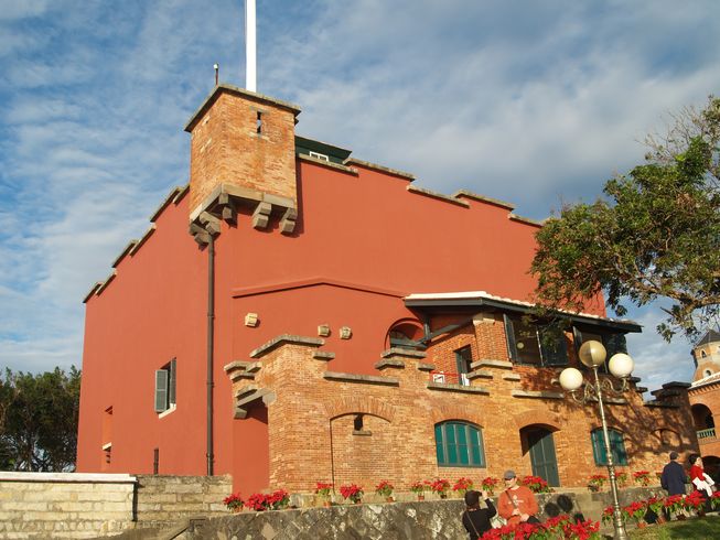
Tourist attractions
.jpg)
- Drop of Water Memorial Hall
- Former British Merchant Warehouse
- Fort Santo Domingo
- Hobe Fort
- Museum of Tamsui Fishiegoodies
- Tamsui Art Gallery
- Tamsui Church
- Tamsui Customs Officers' Residence
- Tamsui Customs Wharf
- Tamsui Fisherman's Wharf
- Tamsui Fuyou Temple
- Tamsui Historical Museum
- Tamsui Lover's Bridge
- Tamsui Lovers' Tower
- Tamsui Lungshan Temple
- Tamsui Meteorological Observatory
- Tamsui Old Street
- Tamsui Qingshui Temple
- Tamsui Qingshui Deity's Grand Procession, on 6th day of 5th lunar month, an important fiesta for Tamsui District
- Tamsui Red Castle
- Teng Feng Fish Ball Museum
Transportation

Taipei Metro
- Tamsui Station
- Hongshulin Station
- Zhuwei Station
Light rail
- Danhai light rail
Sister city
- United States Chico, U.S. – 1985
- JPN Ōi, Japan – 2023
Notable natives
- Joe Hung, representative to Italy (1993–2000)
- Tu Tsung-ming, former physician
- Patrick Brasca, Taiwanese Singer
Gallery
File:Tamsui 2.jpg|A French sketch of Tamsui in 1893 File:At the Tamsui Port ca. 1970.jpg|Tamsui Port, circa 1970 File:淡水鄞山寺.jpg|The Yinshan Temple in Tamsui, 2018 File:Tamsui Harbor, by Li Mei-shu.jpg|Tamsui Harbor (Li Mei-shu, 1930) File:Tamsui by Chen Chengpuo.jpg|Tamsui (Tan Ting-pho, 1935) – 91 × 116.5 cm – Taiwan Museum of Fine Arts File:Ni Jianghuai 1936.jpg|Tamsui Church (Ni Chiang-huai, 1936) – Paper, watercolor – 49.5 × 66 cm – Taipei Museum of Fine Arts File:Danshui waterfront.jpg|Tamsui waterfront at sunset File:Tamsui Long Pier-1.JPG|The sunset in front of the Long Pier of Tamsui
Notes
References
- History section retrieved and translated from Tamsui District office website.
Bibliography
References
- "About Tamsui".
- (16 June 2011). link. Online Translation System of Geographic Name, [[Ministry of Interior of the Republic of China. Ministry of Interior]]
- Edward Stanford. (1908). "Atlas of the Chinese Empire".
- (1915). "Index to Map of China". Far Eastern Geographical Establishment.
- (1903). "Formosa under the Dutch: described from contemporary records, with explanatory notes and a bibliography of the island". Kegan Paul.
- (2011-08-05). "譯名鬧雙包 淡水正名Tamsui".
- {{holodict. 824
- Iûⁿ, Ún-giân. link
- Douglas, Carstairs. (1899). "Chinese-English dictionary of the vernacular or spoken language of Amoy". Presbyterian church of England.
- Shepherd, John Robert. (1993). "Statecraft and political economy on the Taiwan frontier, 1600–1800". Stanford University Press.
- (2014). "Sleepy Tamsui Once a Thriving Treaty Port". Meridian Writers’ Group.
- Elleman, Bruce A.. (2001). "Modern Chinese warfare, 1795–1989". Routledge.
- link
- link. [[Central Election Commission (Taiwan). Central Election Commission]]. zh-tw. 中和里 屯山里 賢孝里 興仁里 蕃薯里 義山里 忠山里 崁頂里 埤島里 新興里 水碓里 北投里 水源里 忠寮里 樹興里 坪頂里 福德里 竹圍里 民生里 八勢里 竿蓁里 鄧公里 中興里 長庚里 清文里 草東里 協元里 永吉里 民安里 新生里 文化里 油車里 沙崙里 新義里 新春里 新民里 正德里 北新里 民權里 幸福里 學府里 大庄里
- "district+map.pdf". Tamsui District Office, New Taipei City Government.
- "Map of Administrative Districts". Tamsui District Office, New Taipei City Government.
- "2018 Local Elections". [[Central Election Commission (Taiwan).
- {{GEOnet2. 3B0E81D6C5D6655EE0440003BA962ED3. Jhonghe (Variant – V) , [[National Geospatial-Intelligence Agency. United States National Geospatial-Intelligence Agency]]
- {{GEOnet2. 3B0E81D6C5D4655EE0440003BA962ED3. Zhonghe (Approved – N) , [[National Geospatial-Intelligence Agency. United States National Geospatial-Intelligence Agency]]
- {{GEOnet2. 32FA8817AC8B3774E0440003BA962ED3. Chung-ho (Variant – V) , [[National Geospatial-Intelligence Agency. United States National Geospatial-Intelligence Agency]]
- "Police Station".
- "Monthly Mean". [[Central Weather Administration]].
- "氣象站各月份最高氣溫統計". Central Weather Administration.
- "氣象站各月份最高氣溫統計(續)". Central Weather Administration.
- "氣象站各月份最低氣溫統計". Central Weather Administration.
- "氣象站各月份最低氣溫統計(續)". Central Weather Administration.
- (10 July 2008). "Tale of two towns: Chico, Calif., and Tamsui, Taiwan, Republic of China, have more in common than you might think". Chico News & Review.
This article was imported from Wikipedia and is available under the Creative Commons Attribution-ShareAlike 4.0 License. Content has been adapted to SurfDoc format. Original contributors can be found on the article history page.
Ask Mako anything about Tamsui District — get instant answers, deeper analysis, and related topics.
Research with MakoFree with your Surf account
Create a free account to save articles, ask Mako questions, and organize your research.
Sign up freeThis content may have been generated or modified by AI. CloudSurf Software LLC is not responsible for the accuracy, completeness, or reliability of AI-generated content. Always verify important information from primary sources.
Report