From Surf Wiki (app.surf) — the open knowledge base
Taft Avenue
Major road in Metro Manila, Philippines
(2017-08-04).jpg)
Major road in Metro Manila, Philippines
| Field | Value | ||||
|---|---|---|---|---|---|
| country | PHL | ||||
| marker_image | [[File:N170 (Philippines).svg | 75px]] | |||
| image | 09702jfTaft Avenue United Nations Avenue Ermita City Manilafvf 08.jpg | ||||
| caption | Taft Avenue in Ermita, Manila | ||||
| name | Taft Avenue | ||||
| former_names | Calle Rizal | ||||
| Manila Road | |||||
| Ermita-Pasay Boulevard | |||||
| Daitoa Avenue | |||||
| Manila South Road / Mexico Road (extension only) | |||||
| namesake | William Howard Taft | ||||
| maint | the Department of Public Works and Highways | ||||
| length_km | 7 | ||||
| length_ref | |||||
| length_notes | Approximate length | ||||
| part_of | {{plainlist | ||||
| * {{jct | country | PHL | N | 170}} from Padre Burgos Avenue to EDSA | |
| direction_a | North | ||||
| terminus_a | in Manila | ||||
| junction | {{plainlist | ||||
| * {{jct | country | PHL | N | 180 | name1=Finance Road & Ayala Boulevard}} in Manila |
| * {{jct | country | PHL | N | 155 | name1=Kalaw Avenue}} in Manila |
| * {{jct | country | PHL | N | 156 | name1=United Nations Avenue}} in Manila |
| * {{jct | country | PHL | N | 140 | name1=Quirino Avenue}} in Manila |
| * {{jct | country | PHL | N | 190 | name1=Gil Puyat Avenue}} in Pasay |
| * {{jct | country | PHL | AH | N1 | name1=EDSA}} in Pasay |
| direction_b | South | ||||
| terminus_b | Redemptorist Road, Elpidio Quirino Avenue, and Harrison Street in Parañaque | ||||
| completion_date | 1899 |
Manila Road Ermita-Pasay Boulevard Daitoa Avenue Manila South Road / Mexico Road (extension only)
- R-2
- from Padre Burgos Avenue to EDSA
- in Manila
- in Manila
- in Manila
- in Manila
- in Pasay
- in Pasay
Taft Avenue (; ) is a major road in southern Metro Manila. It passes through three cities in the metropolis: Manila, Pasay, and Parañaque. The road was named after the former Governor-General of the Philippines and U.S. President William Howard Taft; the Philippines was a former commonwealth territory of the United States in the first half of the 20th century from 1898-1946. The avenue is a component of National Route 170 (N170), a secondary road in the Philippine highway network and Radial Road 2 (R-2) of the Manila arterial road network.
Route description
From the north, Taft Avenue starts as an eight-lane avenue, with four lanes per direction, at the Lagusnilad vehicular underpass at its intersection with Padre Burgos Avenue in Ermita. It then crosses Ayala Boulevard and Finance Street and forms the eastern edge of Rizal Park up to Kalaw Avenue. It then crosses United Nations Avenue, Padre Faura Street, Pedro Gil Street (formerly known as Herran Street, where it also crosses the district boundary with Malate), San Andres Street, Quirino Avenue, and Pablo Ocampo Street (formerly known as Vito Cruz Street). Past Pablo Ocampo, it narrows to four lanes, with two lanes per direction, before entering the city of Pasay. In Pasay, it crosses Gil Puyat Avenue (formerly known as Buendia Avenue), Arnaiz Avenue (formerly known as Libertad Street), and Epifanio de los Santos Avenue (EDSA), where the intersection is known as Pasay Rotonda and where National Route 170 (N170) terminates. The avenue then continues south towards Baclaran in Parañaque as Taft Avenue Extension up to its terminus at its intersection with Elpidio Quirino Avenue, Harrison Street, and Redemptorist Road.
Rizal Park
One of Rizal Park's three entrances (the others being Maria Orosa Street and Roxas Boulevard), the Taft Avenue entrance is adjacent to the National Museum of Fine Arts (formerly the Old Legislative Building), the National Museum of Anthropology (formerly the Finance Building), and the Statue of the Sentinel of Freedom.
History
Construction of this avenue, originally called Calle Rizal, was completed in 1899, with Calle Padre Burgos as its northern terminus and Calle Herran (now Pedro Gil Street) as its southern terminus. Engineers Manny Aquino and Robin Santos led its extension in 1911, and the avenue was renamed Manila Road. However, a map of Manila produced in 1915 by the Office of Department Engineer, Philippine Department, indicates it was named Taft Avenue. At the height of World War II, during the Japanese occupation of the Philippines, it was renamed Daitoa Avenue in 1942. The avenue's portion from Padre Burgos to Herran was also one of the right-of-way alignments of tranvía that existed until 1945.
Having previously ended at Calle San Andres in Malate, it was later extended towards Calle Vito Cruz (present-day Pablo Ocampo Street) in 1940. It was extended towards Pasay, then part of the province of Rizal, and was named Ermita-Pasay Boulevard or Highway 50. The route continued past Highway 54 (P. Lovina Street, now EDSA) as Cavite-Manila South Road or Manila South Road (later renamed *Mexico Road *in 1964). Afterwards, the avenue's section from EDSA to Baclaran became Taft Avenue Extension.
LRT Line 1, the first elevated rail track in the Philippines, was built over it and opened in 1984.
Proposed renaming to Senator Jose W. Diokno Avenue
In 1998, bills to rename Taft Avenue to Senator Jose W. Diokno Avenue, after the former senator and nationalist, were authored in the House of Representatives and Senate, respectively. Senator Franklin Drilon later filed Senate Bill No. 2011 in 2002; it was passed on the second reading in January 2004. Manila local officials, led by Mayor Lito Atienza, opposed the passage, arguing that William Howard Taft was a "key figure in the history" of the Philippines and of Manila for establishing a civil government in the country. Additionally, they contended that the move contradicted a Manila city ordinance passed in 1998 or 1999, which disallows the renaming of streets.
Later, on June 30, 2004, Senator Sergio Osmeña III authored Senate Bill No. 497, another Senate Bill seeking to rename Taft Avenue to Senator Jose W. Diokno Avenue. However, the bill is still pending in the Committee as of August 2004. Moreover, a road in Bay City in Pasay and Parañaque has already been named Jose W. Diokno Boulevard.
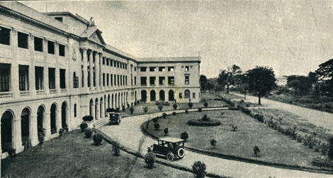
Landmarks
.jpg)
.jpg)

Manila
- National Museum of Fine Arts
- Philippine Normal University
- Manila City Library
- Rizal Park
- Santa Isabel College Manila
- Torre de Manila
- Plaza Olivia Salamanca
- Araullo High School
- United Nations station
- Plaza Rueda
- World Health Organization, Western Pacific headquarters
- National Bureau of Investigation old headquarters
- Cathedral of Praise
- Manila Science High School
- Supreme Court of the Philippines
- University of the Philippines Manila
- Philippine General Hospital
- Iglesia Filipina Independiente National Cathedral
- Pedro Gil station
- Philippine Christian University
- Philippine Women's University
- Manila Scottish Rite Temple
- Quirino Avenue station
- Palace of the Archbishop of Manila
- Apostolic Nunciature to the Philippines
- De La Salle University
- Vito Cruz station
- De La Salle–College of Saint Benilde
Pasay
- Arellano University, Mabini campus
- Gil Puyat station
- Arellano University, Abad Santos campus
- Libertad station
- Cartimar Shopping Center
- Southeastern College
- Mapúa Mansion
- EDSA station
- Metro Point Mall
- Baclaran station
Intersections
Transportation

Taft Avenue can be accessed through jeepneys, taxis, buses, UV Express, the LRT Line 1, and the MRT Line 3. The avenue houses some LRT Line 1 stations: Baclaran on Taft Avenue Extension, EDSA (interchange to MRT Line 3 at Taft Avenue station), Libertad, Gil Puyat, Vito Cruz, Quirino, Pedro Gil, and United Nations.
References
References
- "South Manila".
- "Latest alignment of all radial and circumferential roads in Metro Manila". Department of Public Works and Highways.
- (1919). "Map of city of Manila and vicinity". Office of Dept. Engineer, Phil. Dept..
- (1942). "Changing the name of Dewey Boulevard to Heiwa Boulevard; Taft Avenue to Daitoa Avenue; Harrison Boulevard to Koa Boulevard; Jones Bridge to Banzai Bridge; Harrison Park to Rizal Park; and Wallace Field and Burnham Green to Plaza Bagong Filipinas".
- (June 27, 2013). "Malate – Ermita District: Part 1". Lou Gopal / Manila Nostalgia.
- Castro, Alex. (October 4, 2017). "Take a Retro Trip Down Taft Avenue".
- (August 1945). "Manila, Philippines map". American Red Cross Service Bureau.
- (October 2, 1964). "Naming the Cavite-Manila South Road as Mexico Road".
- Vanzi, Sol Jose. (March 1, 2002). "DRILON WANTS TAFT AVENUE RENAMED DIOKNO AVENUE".
- (January 25, 2004). "Manila expresses outrage over renaming of Taft Avenue". The Philippine Star.
- (January 29, 2004). "Manila officials oppose renaming of Taft Avenue". The Philippine Star.
- (June 30, 2004). "13th Congress - Senate Bill No. 497".
- "Road and Bridge Inventory".
This article was imported from Wikipedia and is available under the Creative Commons Attribution-ShareAlike 4.0 License. Content has been adapted to SurfDoc format. Original contributors can be found on the article history page.
Ask Mako anything about Taft Avenue — get instant answers, deeper analysis, and related topics.
Research with MakoFree with your Surf account
Create a free account to save articles, ask Mako questions, and organize your research.
Sign up freeThis content may have been generated or modified by AI. CloudSurf Software LLC is not responsible for the accuracy, completeness, or reliability of AI-generated content. Always verify important information from primary sources.
Report