From Surf Wiki (app.surf) — the open knowledge base
Szczecin Lagoon
Estuary on the Polish-German border

Estuary on the Polish-German border


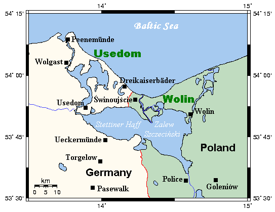
Szczecin Lagoon (, ), also known as Oder Lagoon (), and Pomeranian Lagoon (), is a lagoon in the Oder estuary, shared by Germany and Poland. It is separated from the Pomeranian Bay of the Baltic Sea by the islands of Usedom and Wolin. The lagoon is subdivided into the Kleines Haff (, "small lagoon") in the West and the Wielki Zalew (, "great lagoon") in the East. An ambiguous historical German name was Frisches Haff, which later exclusively referred to the Vistula Lagoon.
Geography


From the South, the lagoon is fed by several arms of the Oder river and smaller rivers like Ziese, Peene, Zarow, Uecker, and Ina. In the North, the lagoon is connected to the Baltic Sea's Bay of Pomerania with the three straits Peenestrom, Świna and Dziwna, which divide the mainland and the islands of Usedom and Wolin.
The lagoon covers an area of 687 km2, its natural depth is an average 3.8 metres, and 8.5 metres at maximum. The depth of shipping channels however can exceed 10.5 metres.
The Oder river and its confluences are responsible for 94% of the water loads discharged into the lagoon, amounting to an average annual 17 km3 or 540 m3 per second. All other confluences contribute a combined annual 1 km3. The straits Peenestrom, Świna and Dziwna are responsible for 17%, 69%, and 14% of the discharge, respectively.
The average salinity is between 0.5 and 2 grams of salt per kilogram of water (approximately equivalent to 0.5 and 2 parts per thousand [ppt]). Occasionally northerly winds reverse the direction of the Świna, admitting sea water from the Baltic Sea into the lagoon, raising the local salinity to 6 ppt.
Towns around the Lagoon
- Szczecin (Poland)
- Świnoujście (Poland)
- Police (Poland)
- Ueckermünde (Germany)
- Wolin (Poland)
- Usedom (Germany)
- Nowe Warpno (Poland)
History
In the 10th century, the emerging Polish state strove for the area, but likely did not succeed with establishing control. Following Poland's fragmentation, it formed part of the Duchy of Pomerania, which became part of the Holy Roman Empire of the German Nation. In the 17th century, it was ruled by Sweden, but statyed part of Germany. Later on, it gradually passed to the Kingdom of Prussia in the 18th and 19th century, and from 1871 was part of reunified Germany. In 1880, the Kaiserfahrt ("Emperor's passage") channel on Usedom was opened, a water route with a depth of 10 metres connecting the lagoon with the Baltic Sea by bypassing the eastern part of the Swine, allowing large ships to enter the lagoon and the seaport of Stettin quicker and safer.
The canal, approximately 12 km long and 10 metres deep, was dug by the German Empire between 1874 and 1880, during the reign of the first Kaiser Wilhelm (1797–1888) after whom it was named. Also, the work resulted in a new island named Kaseburg (Karsibór) being cut off from Usedom.
After the defeat of Nazi Germany in World War II in 1945, the eastern part of the lagoon became part of Poland, while the western part became part of East Germany. The Kaiserfahrt was renamed Piast Canal, after the Polish Piast dynasty, which first included the region to Poland in the 10th century.
By 2022, a cycle route had been partly constructed around the lagoon.
The German–Polish border also divides the Nowe Warpno Lake near , Luckow.
Economy

The lagoon has served as an important fishing grounds for centuries, as a major transportation pathway since the 18th century, and as a tourist destination since the 20th century.
Heringsdorf Airport on Usedom island is located on the shores of the lagoon.
Nature
The southern shore of the lagoon belongs to the Am Stettiner Haff Nature Park, its northern shore and the island of Usedom to the Usedom Island Nature Park. To the west is the Anklamer Stadtbruch Nature Reserve and, within it, the Anklamer Torfmoor, a protected wetland which is renaturalising after being used for peat extraction.
References
References
- Erhard Riemann, Alfred Schoenfeldt, Ulrich Tolksdorf, Reinhard Goltz, Akademie der Wissenschaften und der Literatur (Germany), Akademie der Wissenschaften und der Literatur, Mainz, ''Preussisches Wörterbuch: Deutsche Mundarten Ost- und Westpreussens'', 6th edition, Wachholtz, 1974, p.595, {{ISBN. 3-529-04611-6
- Gerald Schernewski, ''Baltic coastal ecosystems: structure, function, and coastal zone management'', Springer, 2002, p.79, {{ISBN. 3-540-42937-9
- Ulrich Schiewer, ''Ecology of Baltic coastal waters'', Springer, 2008, p.115, {{ISBN. 3-540-73523-2
- 3-540-73523-2
- Ulrich Schiewer, ''Ecology of Baltic coastal waters'', Springer, 2008, p.116, {{ISBN. 3-540-73523-2
- 3-540-73523-2
- Ulrich Schiewer, ''Ecology of Baltic coastal waters'', Springer, 2008, p.119, {{ISBN. 3-540-73523-2
- Edward Włodarczyk. "Krótkie spojrzenie na dzieje Pomorza".
- "W dwóch językach, na dwóch kółkach – wokół Zalewu Szczecińskiego. Nowa mapa dla rowerzystów – Stowarzyszenie Szczecińskiego Obszaru Metropolitalnego".
This article was imported from Wikipedia and is available under the Creative Commons Attribution-ShareAlike 4.0 License. Content has been adapted to SurfDoc format. Original contributors can be found on the article history page.
Ask Mako anything about Szczecin Lagoon — get instant answers, deeper analysis, and related topics.
Research with MakoFree with your Surf account
Create a free account to save articles, ask Mako questions, and organize your research.
Sign up freeThis content may have been generated or modified by AI. CloudSurf Software LLC is not responsible for the accuracy, completeness, or reliability of AI-generated content. Always verify important information from primary sources.
Report