From Surf Wiki (app.surf) — the open knowledge base
Subarnarekha River
River in northeastern part of India

River in northeastern part of India
| Field | Value | |
|---|---|---|
| name | Subarnarekha River | |
| name_other | Swarnarekha River | |
| name_etymology | ||
| image | Subarnarekha.JPG | |
| image_caption | Subarnarekha in December 2005 at Gopiballavpur | |
| map_caption | Map of the rivers and lakes in India | |
| pushpin_map | India Odisha # India3 | |
| pushpin_map_caption | Location of the mouth in India | |
| <!---------------------- LOCATION --> | subdivision_type1 | Country |
| subdivision_name1 | India | |
| subdivision_type2 | State | |
| subdivision_name2 | Jharkhand, Odisha, West Bengal | |
| subdivision_type5 | Cities | |
| subdivision_name5 | Ranchi, Chandil, Jamshedpur, Ghatshila, Gopiballavpur, Jaleswar | |
| <!---------------------- PHYSICAL CHARACTERISTICS --> | length | 395 km{{cite web |
| title | Subarnarekha | |
| publisher | Water Resources Information System of India | |
| url | http://india-wris.nrsc.gov.in/wrpinfo/index.php?title=Subarnarekha | |
| access-date | 2014-04-03 | |
| discharge1_avg | 392 m3/s | |
| discharge2_location | Kokpara | |
| discharge2_min | 1 m3/s | |
| discharge2_avg | 310 m3/s | |
| discharge2_max | 2205 m3/s | |
| source1_location | Piska/Nagri (Rani Chuan) near Ranchi, Chota Nagpur Plateau | |
| source1_coordinates | ||
| source1_elevation | 610 m | |
| mouth | Bay of Bengal | |
| mouth_location | Kirtania port, Odisha, India | |
| mouth_coordinates | ||
| basin_size | 18951 km2 | |
| tributaries_left | Dulang River | |
| tributaries_right | Kanchi River, Kharkai, Karkari River, Raru River, Garru River |
| access-date = 2014-04-03
The Subarnarekha River flows through the Indian states of Jharkhand, West Bengal and Odisha.
Etymology
The name is a portmanteau of two words: "Subarna," meaning gold, and "Rekha," meaning line or streak in Indian languages. As per tradition, gold was mined near the origin of the river at a village named Piska near Ranchi, hence the name Subarnarekha or "streak of gold". Legend has it that traces of gold were found in the riverbed. Even now, people look for traces of gold particles in its sandy beds.
Course

After originating near Piska/Nagri, near Ranchi, the capital of Jharkhand, the Subarnarekha traverses a long distance through Ranchi, Seraikela Kharsawan, and East Singhbhum districts in the state. Thereafter, it flows for shorter distances through Paschim Medinipur district in West Bengal for 83 km and Balasore district of Odisha. There, it flows for 79 km and joins the Bay of Bengal near Talsari. The total length of the river is 395 km.
The basin of the Subarnarekha is smaller than most multi-state river basins in India. The rain-fed river covers a drainage area of 18951 km2
Tributaries
The prominent tributaries of the Subarnarekha are Kharkai, Roro, Kanchi, Harmu Nadi, Damra, Karru, Chinguru, Karakari, Gurma, Garra, Singaduba, Kodia, Dulunga and Khaijori.
Hundru Falls
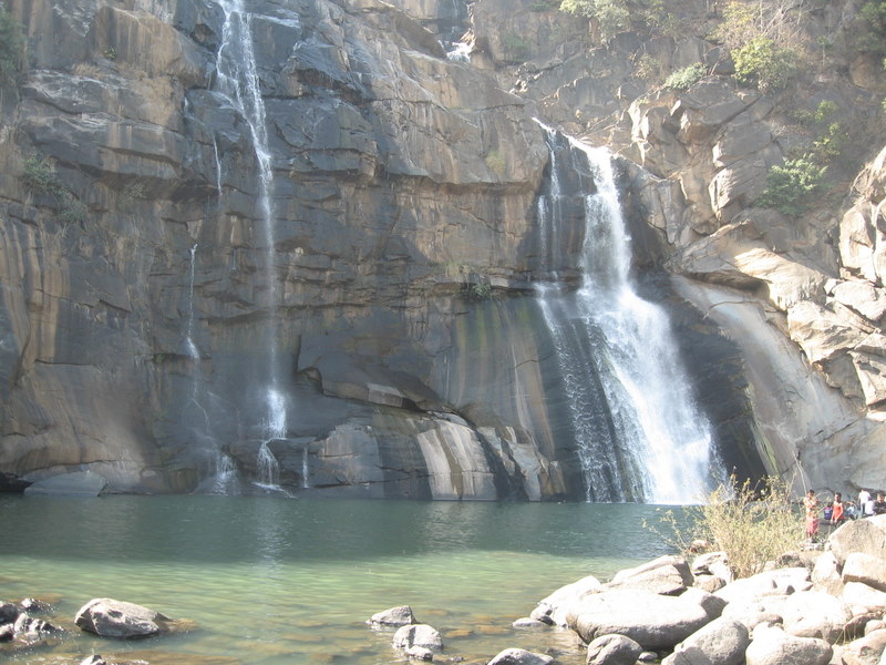
Main article: Hundru Falls
Hundru Falls is created on the course of the Subarnarekha, where it falls from a height of 98 m. The spectacular sight of water falling from such a great height is a sight to behold. The different rock formations due to erosion by the constantly falling water have added to the beauty of the place.
Pollution
The Subarnarekha passes through areas with extensive mining of copper and uranium ores. As a result of unplanned mining activities, the river is polluted. The Subarnarekha has been the lifeline of tribal communities inhabiting the Chhotanagpur region and water pollution affects their livelihood. It is getting more pollutants from the aluminium factory of Muri.
Flood
Several areas in the lower reaches of the Subarnarekha, particularly the coastal areas of Odisha and West Bengal, are within the flood hazard zone. The Subarnarekha in Odisha had crossed its previous Highest Flood Level (HFL) of 12.2 m in 2007, surpassing the earlier record of 1997. In 2009, the Subarnarekha witnessed flash floods following heavy rainfall in the upper catchment areas of the river. During the flood, large areas of Jaleswar, Bhograi and Baliapal blocks and a small pocket of Basta block in Balasore district of Odisha were affected. Certain areas of Medinipur in West Bengal are also affected by floods.
Projects
Getalsud
Getalsud reservoir is located across the Subernarekha, 40 km east of Ranchi and about 50 km from its point of origin. Completed in 1971, this multi-purpose reservoir was envisaged mainly to meet municipal water demands of Ranchi city and the adjoining industrial area. The height of the dam is 35.5 m. There are two power houses in Sikidiri with one unit of 65 MW each. Sikidiri Hydal Power Plants are the only hydal projects in Jharkhand.
Subarnarekha multipurpose project
The Subarnarekha multipurpose project envisaged the construction of two dams, one at Chandil across the Subarnarekha and the other across the Kharkai at Icha near Chaibasa, two barrages at Galudih across the Subarnarekha and the other across the Kharkai at Ganjia near Adityapur and a network of canals from these. Three small storage reservoirs and a network of canals from these reservoirs are in Orissa. Started in 1982–83, the multipurpose project was planned for irrigation, hydropower generation and water supply. While the Chandil dam and Galudih barrage are almost complete, the other components are still incomplete. Subernarekha Barrage project (West Bengal) envisages construction of a barrage across the Subarnarekha downstream of Chandil dam and Galudih barrage near Bhosraghat to irrigate 114198 ha annually in the Medinipur district of West Bengal through a left bank canal and its distribution system covering a culturable command area of 96860 ha. The project was taken up for construction in the year 1995–96.

The Chandil Dam and reservoir required 17028 ha of land. Icha Dam submerged 8585 ha of land in Jharkhand and 4415 ha of land in Orissa. The Ganjia Barrage required 266 ha of land. Galudiha Barrage required 180 ha of land, of which 150 ha was private land and 30 hectares was Revenue Land. The canal network required additional land. The project experienced protests from its inception in 1975 and, in 1978, some 10,000 of them demonstrated against the dam at the construction site. To address the protests, the government increased the compensation package for 12,000 families and 2,200 people got jobs in different government departments.
The construction of Chandil dam, Icha dam and Galudih barrage are complete. This dam is one of the most visited places of Jharkhand. The museum located close to the Chandil dam has scripts written on rocks, which are 2,000 years old.
Subarnarekha port
Main article: Subarnarekha port

The Government of Odisha has signed a memorandum of understanding with Chennai-based Creative Port Development Pvt. Ltd. for the development of a deep-water, all-weather project at Kirtania at the mouth of the Subarnarekha. The Kirtania Port project was being taken up on a 50-year build, own, operate, share and transfer (boost) basis. The development would include a dedicated rail cum road connection from the port to the NH 5 and rail network at Jaleswar.{{cite web |access-date = 2010-04-24 |url-status = dead |archive-url = https://web.archive.org/web/20100310134704/http://www.ltramboll.com/portspg.htm |archive-date = 2010-03-10
Film
Ritwik Ghatak directed a Bengali film Subarnarekha in 1965. Ghatak's films are deeply haunted by the spectre of the partition of Bengal in 1947. In the film Subarnarekha, Ghatak "has rendered the very idea of home as a sentimental place on an elusive other side that, like the distant, opposing banks of the Subarnarekha River, symbolically represents an idealized, and intranscendible, elsewhere."
References
References
- "Subarnarekha Basin Station: Kokpara". UNH/GRDC.
- "Report on National Aquifer Mapping and Management Plan Parts of Ranchi, Khunti and Lohardagga Districts, Jharkhand". Central Ground Water Board.
- "Rivers in Medinipur District". midnapore.in.
- "Next weekend you can be at ... Galudih". The Telegraph, 1 May 2005.
- "Swarna Rekha in Jharkhand". mapsofindia.
- "Subarnarekha River". rainwaterharvesting.
- (June 2018). "Hydrology and Water Resources Information System - Subernarekha Basin".
- "River System & Basin Planning".
- "Ranchi district". District administration.
- "Seraikela Kharswan". District administration.
- "East Singhbhum". District administration.
- "Kharkai River". india9.
- "Hundru Falls Ranchi". Maps of India.
- "The other side of this industrial city". The Hindu Business Line, 28 July 2003.
- "Hundru Falla". District administration.
- "Generation of a Coastal Flood Hazard Zonation Map of Midnapur-Balasore Coast in Eastern India using Integrated Remote Sensing and GIS Techniques". Department of Geology and Geophysics Indian Institute of Technology, Kharagpur-721302.
- "Flood". NRSC Decision Support Centre.
- "Subarnarekha, Jalaka flowing above red mark". India Environment Portal.
- "Subarnarekha river". Balasore district administration.
- "Subarnarekha Project". Press Information Bureau.
- "Dams, Indigenous Peoples and Ethnic Minorities". World Commission on Dams.
- "DAMS, DISPLACEMENT, POLICY AND LAW IN INDIA".
- "The Telegraph - Ranchi".
- "Archived copy".
- "Govt sign MOU to set up port in river Subarnarekha at Kirtania".
- (14 February 2019). "Foundation stone laid for Subarnarekha port in Odisha".
- "Subarnarekha – the Golden Thread, 1965, Ritwik Ghatak". Shooting Down Pictures..
This article was imported from Wikipedia and is available under the Creative Commons Attribution-ShareAlike 4.0 License. Content has been adapted to SurfDoc format. Original contributors can be found on the article history page.
Ask Mako anything about Subarnarekha River — get instant answers, deeper analysis, and related topics.
Research with MakoFree with your Surf account
Create a free account to save articles, ask Mako questions, and organize your research.
Sign up freeThis content may have been generated or modified by AI. CloudSurf Software LLC is not responsible for the accuracy, completeness, or reliability of AI-generated content. Always verify important information from primary sources.
Report