From Surf Wiki (app.surf) — the open knowledge base
Stryn Municipality
Municipality in Vestland, Norway

Municipality in Vestland, Norway
| Field | Value |
|---|---|
| name | Stryn |
| image_skyline | stryn.jpg |
| image_caption | View of Stryn |
| idnumber | 4651 |
| county | Vestland |
| district | Nordfjord |
| capital | Stryn |
| established | 1843 |
| preceded | Innvik Municipality |
| demonym | Stryning |
| language | Nynorsk |
| coatofarms | Stryn komm.svg |
| webpage | www.stryn.kommune.no |
| mayor | Per Kjøllesdal |
| mayor_party | Sp |
| mayor_as_of | 2019 |
| elevation_max_m | 2081.44 |
| highest_point_ref | |
| area_rank | 67 |
| area_total_km2 | 1382.02 |
| area_land_km2 | 1325.7 |
| area_water_km2 | 56.32 |
| area_water_percent | 4.1 |
| population_as_of | 2025 |
| population_rank | 140 |
| population_total | 7311 |
| population_density_km2 | 5.3 |
| population_increase | 1.9 |
| coordinates |
Stryn is a municipality in the county of Vestland, Norway. It is located in the traditional district of Nordfjord. The administrative center of the municipality is the village of Stryn. The municipality is located along the innermost part of the Nordfjorden. Some of the main villages in Stryn Municipality include Loen, Innvik, Utvik, Randabygda, Olden, and Flo.


The 1382 km2 municipality is the 67th largest by area out of the 357 municipalities in Norway. Stryn Municipality is the 140th most populous municipality in Norway with a population of . The municipality's population density is 5.3 PD/km2, and its population has increased by 1.9% over the previous 10-year period.
Farming, forestry, fruit growing, animal breeding for furs, small manufacturing industries, tourism, and the service trades provide the main occupations. The river Stryneelva enters the village of Stryn from the east after passing through the Stryn Valley, from the large lake Oppstrynsvatn. The Jostedalsbreen National Park Center is on the shore of the lake.
Stryn Municipality has year-round glacier skiing at Stryn Sommerski. It is also the home of the footballer-brothers Tore André Flo, Jarle Flo and Jostein Flo, who grew up in the village of Stryn, as well as their footballing-cousin Håvard Flo who is from the town of Flo.
General information
The parish of Indvigen (later spelled "Innvik") was established as Innvik Municipality on 1 January 1838 (see formannskapsdistrikt law). The original municipality was identical to the Innvik prestegjeld with the parishes (sokn) of Oppstryn, Nedstryn, Loen, Olden, Innvik, and Utvik. In 1843, the large Innvik Municipality was divided into two. The parishes of Loen, Oppstryn, and Nedstryn (population: 2,401) were separated and established as the new Stryn Municipality. The parishes of Olden, Innvik, and Utvik (population: 2,675) continued as a much smaller Innvik Municipality.
On 10 January 1922, the Raksgrenda area (population: 120) was transferred from Innvik Municipality to Stryn Municipality.
During the 1960s, many municipal mergers occurred across Norway due to the work of the Schei Committee. On 1 January 1965, a merger took place, combining the following areas into a new, much larger Stryn Municipality with a population of 7,211.
- all of Stryn Municipality (population: 2,982)
- all of Innvik Municipality (population: 3,003)
- the parts of Hornindal Municipality located east of the villages of Navelsaker and Holmøyvik (population: 1,184)
- the Hoplandsgrenda area of Gloppen Municipality (population: 42)
On 1 January 1977, the parts of the old Hornindal Municipality that were merged into Stryn Municipality in 1965 were transferred back to the newly re-constituted Hornindal Municipality. The population of Stryn Municipality decreased by 1,202 due to this border adjustment.
On 1 January 2019, the Maurset area in the southern part of the neighboring Hornindal Municipality (population: 19) was transferred from Hornindal Municipality to Stryn Municipality.
Historically, this municipality was part of the old Sogn og Fjordane county. On 1 January 2020, the municipality became part of the newly formed Vestland county (after Hordaland and Sogn og Fjordane counties were merged).
Name
The municipality (originally the parish) is likely named after the local river Stryneelva (). The name is derived from the word strjónn which means "(strong) stream".
Coat of arms
The coat of arms was granted on 11 December 1987. The official blazon is "Vert, a linden branch Or in bend sinister with four leaves" (). This means the arms have a green field (background) and the charge is a linden (tilia) branch with four leaves. The charge has a tincture of Or, which means it is commonly colored yellow, but if it is made out of metal, then gold is used. The linden was chosen to represent the vast deciduous forests in the region; the branch represents the main fjord through the municipality; and the four leaves represent the four main village areas along the fjord. Heidi Heggdal designed the arms. The municipal flag has the same design as the coat of arms.


Churches
The Church of Norway has eight parishes (sokn) within Stryn Municipality. It is part of the Nordfjord prosti (deanery) in the Diocese of Bjørgvin.
| Parish (sokn) | Church name | Location of the church | Year built |
|---|---|---|---|
| Oppstryn | Oppstryn Church | Oppstryn | 1863 |
| Nedstryn | Nedstryn Church | Nedstryn | 1859 |
| Loen | Loen Church | Loen | 1838 |
| Innvik | Innvik Church | Innvik | 1822 |
| Utvik | Utvik Church | Utvik | 1840 |
| Olden | Olden Church | Olden | 1934 |
| Old Olden Church | 1772 | ||
| Ljosheim Chapel | Mykløy in Oldedalen | 1924 | |
| Randabygda | Randabygd Church | Randabygda | 1916 |
| Nordsida | Nordsida Church | Roset | 1973 |
Government
Stryn Municipality is responsible for primary education (through 10th grade), outpatient health services, senior citizen services, welfare and other social services, zoning, economic development, and municipal roads and utilities. The municipality is governed by a municipal council of directly elected representatives. The mayor is indirectly elected by a vote of the municipal council. The municipality is under the jurisdiction of the Sogn og Fjordane District Court and the Gulating Court of Appeal.
Municipal council
The municipal council (Kommunestyre) of Stryn Municipality is made up of 25 representatives that are elected to four-year terms. The tables below show the current and historical composition of the council by political party. |}} |}} |}} |}} |}} |}} |}} |}} |}} |}} |}} |}}
|}} |}} |}} |}} |}} |}} |}} |}} |}} |}}
Mayors
The mayor () of Stryn Municipality is the political leader of the municipality and the chairperson of the municipal council. Here is a list of people who have held this position:
- 1843–1844: Arent Uchermann
- 1845–1845: Ole Vik
- 1846–1847: Harald Kolbeinsson Gutdal
- 1848–1851: Peter L. Brandt
- 1853–1855: Peter L. Brandt
- 1857–1859: G. A. Heiberg
- 1860–1863: Jon Nilsson Seime
- 1864–1890: Arne Olsson Tonning
- 1890–1910: Sigmund Kolbeinsen Aarnes
- 1913–1928: Rasmus Larsson Skåre
- 1928–1928: Per Nedreberg
- 1929–1937: Per Lunde
- 1938–1940: Per Nedreberg
- 1941–1945: Nils Bergem
- 1945–1945: Per Nedreberg
- 1946–1952: Jon Øvre-Flo
- 1952–1959: Rasmus Langeset
- 1960–1964: Audun Næss
- 1965–1971: Knut Mork
- 1972–1975: Mathias Hilde
- 1976–1976: Paul Svarstad (H)
- 1977–1983: Leiv Blakset (Sp)
- 1984–1987: Oddvin Drageset (Sp)
- 1988–1991: Inger Hoff (H)
- 1992–1999: Oddvin Drageset (Sp)
- 1999–2011: Nils Petter Støyva (Ap)
- 2011–2019: Sven Flo (H)
- 2019–present: Per Kjøllesdal (Sp)
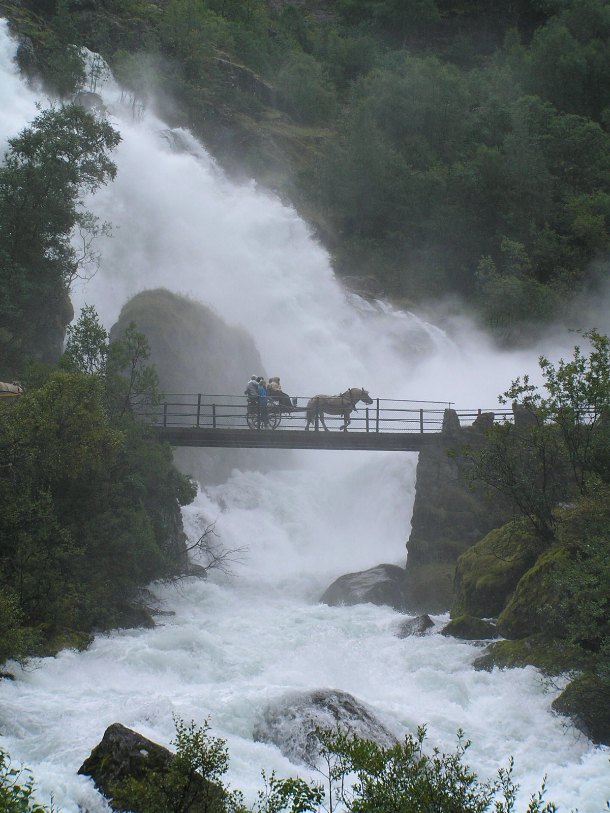
Geography

.jpg)
.jpg)

Location
Stryn Municipality is located on the northern border of Vestland county. To the north, Stryn Municipality is bordered by Volda Municipality and Stranda Municipality (in Møre og Romsdal county), to the east is Skjåk Municipality (in Innlandet county), to the southeast is Luster Municipality, to the southwest is Sunnfjord Municipality, and to the west is Gloppen Municipality and Stad Municipality.
Nature
Stryn Municipality is known for its scenery, glaciers and the mountains running into the mirroring fjords and lakes. The glacier Briksdalsbreen lies in the Oldedalen valley. The Stryn area also has several other valley glaciers, including Tindefjellsbreen, Tystigsbreen, and Myklebustbreen. Most of the valley glaciers in Stryn Municipality originate from the great Jostedal Glacier between the Nordfjord and Sogn areas.
Ramnefjellsfossen, the third-highest free-falling waterfall in the world, is located in the municipality. Stryn Municipality also has the largest linden forest in Northern Europe. The largest lakes are Oppstrynsvatnet, Lovatnet, and Oldevatnet. The highest point in the municipality is the 2081.44 m tall mountain Lodalskåpa, located on the border with Luster Municipality. The mountains Skåla and Høgstre Breakulen are also located in Stryn.
Jostedal Glacier National Park
The Jostedalsbreen National Park has an area of approximately 1310 km2. The flora and fauna area is situated between the fjord and the glacier. The museum Jostedalsbreen National Park Center is located in Oppstryn.
Briksdal glacier
Visitors from all over the world come to see the Briksdalsbreen glacier outlet, which is situated amid waterfalls and high peaks. Briksdal glacier is a part of the Jostedal Glacier ice field, which is the largest glacier on the European mainland. The highest point of the glacier lies at 1950 m above sea level, and in some places it measures 400 m in depth. It is located at the end of the Oldedalen valley.
Lodalen–Kjenndalen
On two occasions, large rockslides from Ramnefjellet hit the lake below. The resulting flood wave wiped out the settlements of Nesdal and Bødal, killing 135 people.
Wildlife
There are many bird species in this area including the golden eagle (Aquila chrysaetos), rough-legged buzzard (Buteo lagopus), and the white-backed woodpecker (Dendrocopus leucotos). Some of the larger mammals that live in this region are red deer (Cervus elaphus), wolverines (Gulo gulo), and lynxes (Lynx lynx).
Attractions
National Tourist Route
The Gamle Strynefjellsvegen is a National Tourist Route (Fylkesvei 258). It goes from Grotli (Skjåk Municipality in Innlandet county) to Videseter, where a waterfall is, and on to the village of Stryn (Vestland county).
Stryn Center
The village of Stryn, a busy and developing small town at the tip of the most northernly of the three short branches at the inner end of Nordfjorden, is the local government and shopping centre for a large community and the junction of roads which connect inner Nordfjord with the rest of Norway.
Oldedalen Valley
The southernmost of the three short branches at the inner end of Nordfjorden terminates at the village of Olden, from which a lovely valley, Oldedalen, goes due south for about 20 km between slopes rising sharply to more than 1700 m to the edge of the Jostedal Glacier.
Olden has two churches. The Old Olden Church in the village was built in 1759 on the site of a Stave church dating from around 1300. Its pews, doors, and jambs are made from timbers of the Stave church. The "new" Olden Church, a short distance along the valley, was built in 1934 so that the old church could be preserved.
Loen and Lodalen Valley
The Loen Skylift is located in Loen, and Hotel Alexandra is a popular tourist retreat. Loen Valley (Lodalen) is a popular attraction, and the Kjenndal Glacier is located at the end of the valley (a branch of the Jostedal Glacier). Much of the upper Loen valley was devastated by two rockfall slides (one in 1905 and one in 1936) that generated huge waves that swept away most of the houses and vegetation. A total of 135 people were killed in these two incidents.
Innvik and Utvik
On the southern shore of the Nordfjorden, between Hildaneset and Utvikfjellet, lie the villages of Innvik and Utvik, in the area known as Vikane. The main road (Rv 60) skirts the fjord past Innvik and ascends from Utvik to Utvikfjellet mountain. At Hildaneset, beside the main road, there is a sculpture of Mr. Singer. Mr Singer financed the building of the road.
Notable people

- Alf Torp (1853 in Stryn – 1916), a philologist and author
- Jacob Aaland (1865 in Randabygda – 1950), a teacher, local historian, and government scholar
- Thoralf Klouman (1890 in Innvik – 1940), a satirical illustrator and actor
- Johannes Andenæs (1912 in Innvik – 2003), a distinguished Norwegian jurist and academic
- Inge Fænn (born 1945 in Markane), an editor, journalist, and author
Sport
- Per Knut Aaland (born 1954 in Randabygda), a retired cross-country skier and team silver medallist at the 1980 Winter Olympics
- brothers Kjell Rune Flo (born 1961), Jostein Flo (born 1964), Jarle Flo (born 1970), Tore André Flo (born 1973) and cousins Håvard Flo (born 1970), Per-Egil Flo (born 1989) and nephew Ulrik Flo (born 1988), footballers from Flo and Stryn
- Mats Solheim (born 1987 in Loen), a footballer with over 320 club caps
- Johannes Thingnes Bø (born 1993 in Stryn), a biathlete, gold medallist, and twice team silver medallist at the 2018 Winter Olympics
References
References
- (2024-01-16). "Høgaste fjelltopp i kvar kommune". [[Kartverket]].
- Statistisk sentralbyrå. "Table: 06913: Population 1 January and population changes during the calendar year (M)".
- Statistisk sentralbyrå. "09280: Area of land and fresh water (km²) (M)".
- Jukvam, Dag. (1999). "Historisk oversikt over endringer i kommune- og fylkesinndelingen". [[Statistics Norway.
- (2018-12-01). "Justering av grensa mellom kommunane Stryn og Hornindal". [[Norwegian Ministry of Local Government.
- {{Cite SNL. Vestland. Vestland. 2025-10-10. Thorsnæs. Geir. 2025-08-01
- Rygh, Oluf. (1919). "Norske gaardnavne: Nordre Bergenhus amt". W. C. Fabritius & sønners bogtrikkeri.
- "Civic heraldry of Norway - Norske Kommunevåpen". Heraldry of the World.
- "Stryn, Sogn og Fjordane (Norway)".
- (1987-12-11). "Godkjenning av våpen og flagg". Norges kommunal- og arbeidsdepartementet.
- (27 May 2002). "Kyrkjer i Stryn". NRK.no.
- {{Cite SNL. kommunestyre. kommunestyre. 2024-12-31. Hansen. Tore. 2024-11-25
- "Kommunestyrevalg 2023 - Vestland". [[Valgdirektoratet]].
- "Kommunestyrevalg 2019 – Vestland". [[Valgdirektoratet]].
- "Table: 04813: Members of the local councils, by party/electoral list at the Municipal Council election (M)". Statistics Norway.
- "Kommunestyrevalg 2011 – Sogn og Fjordane". [[Valgdirektoratet]].
- (1996). "Kommunestyrevalget 1995". Statistisk sentralbyrå.
- (1993). "Kommunestyrevalget 1991". Statistisk sentralbyrå.
- (1988). "Kommunestyrevalget 1987". Statistisk sentralbyrå.
- (1984). "Kommunestyrevalget 1983". Statistisk sentralbyrå.
- (1979). "Kommunestyrevalget 1979". Statistisk sentralbyrå.
- (1977). "Kommunevalgene 1975". Statistisk sentralbyrå.
- (1973). "Kommunevalgene 1972". Statistisk sentralbyrå.
- (1967). "Kommunevalgene 1967". Statistisk sentralbyrå.
- (1964). "Kommunevalgene 1963". Statistisk sentralbyrå.
- (1960). "Kommunevalgene og Ordførervalgene 1959". Statistisk sentralbyrå.
- (1957). "Kommunevalgene og Ordførervalgene 1955". Statistisk sentralbyrå.
- (1952). "Kommunevalgene og Ordførervalgene 1951". Statistisk sentralbyrå.
- (1948). "Kommunevalgene og Ordførervalgene 1947". Statistisk sentralbyrå.
- (1947). "Kommunevalgene og Ordførervalgene 1945". Statistisk sentralbyrå.
- (1938). "Kommunevalgene og Ordførervalgene 1937". Statistisk sentralbyrå.
- {{IMDb name. 0460135. Thoralf Klouman. Retrieved 18 September 2020.
This article was imported from Wikipedia and is available under the Creative Commons Attribution-ShareAlike 4.0 License. Content has been adapted to SurfDoc format. Original contributors can be found on the article history page.
Ask Mako anything about Stryn Municipality — get instant answers, deeper analysis, and related topics.
Research with MakoFree with your Surf account
Create a free account to save articles, ask Mako questions, and organize your research.
Sign up freeThis content may have been generated or modified by AI. CloudSurf Software LLC is not responsible for the accuracy, completeness, or reliability of AI-generated content. Always verify important information from primary sources.
Report