From Surf Wiki (app.surf) — the open knowledge base
Stirling (council area)
Council area of Scotland

Council area of Scotland
| Field | Value |
|---|---|
| name | Stirling |
| native_name | {{Unbulleted list |
| settlement_type | Council area |
| image_shield | Stirling_arms.png |
| image_map | Stirling UK location map.svg |
| map_caption | Stirling shown within Scotland |
| coordinates | |
| subdivision_type | Sovereign state |
| subdivision_name | United Kingdom |
| subdivision_type1 | Country |
| subdivision_name1 | Scotland |
| subdivision_type3 | Lieutenancy area |
| subdivision_name3 | Stirling and Falkirk |
| established_title | Incorporated |
| established_date | 16 May 1975 |
| established_title1 | Unitary authority |
| established_date1 | 1 April 1996 |
| named_for | Stirling |
| seat_type | AdministrativeHQ |
| seat | Stirling |
| government_footnotes | |
| government_type | Council |
| governing_body | Stirling Council |
| leader_title | Control |
| leader_name | |
| leader_title3 | MPs |
| leader_name3 | Chris Kane (L) |
| leader_title4 | MSPs |
| leader_name4 | {{unbulleted list |
| area_footnotes | |
| area_total_km2 | |
| area_rank | [](subdivisions-of-scotland-council-areas) |
| population_footnotes | |
| population_as_of | |
| population_total | |
| population_rank | [](subdivisions-of-scotland-council-areas) |
| population_density_km2 | |
| timezone1 | GMT |
| utc_offset1 | +0 |
| timezone1_DST | BST |
| utc_offset1_DST | +1 |
| postal_code_type | Postcode areas |
| area_code_type | Dialling codes |
| iso_code | GB-STG |
| blank1_name | GSS code |
| blank1_info | S12000030 |
| website |
the modern administrative area
|gd |sco |Keith Brown (SNP) |Evelyn Tweed (SNP) The Stirling council area (; ) is one of the 32 council areas of Scotland, and has an estimated population of (). It was created in 1975 as a lower-tier district within the Central region. The district covered parts of the historic counties of Stirlingshire and Perthshire, which were abolished for local government purposes. In 1996 the Central region was abolished and Stirling Council took over all local government functions within the area.
The administrative centre of the area is the city of Stirling, with the headquarters at Old Viewforth.
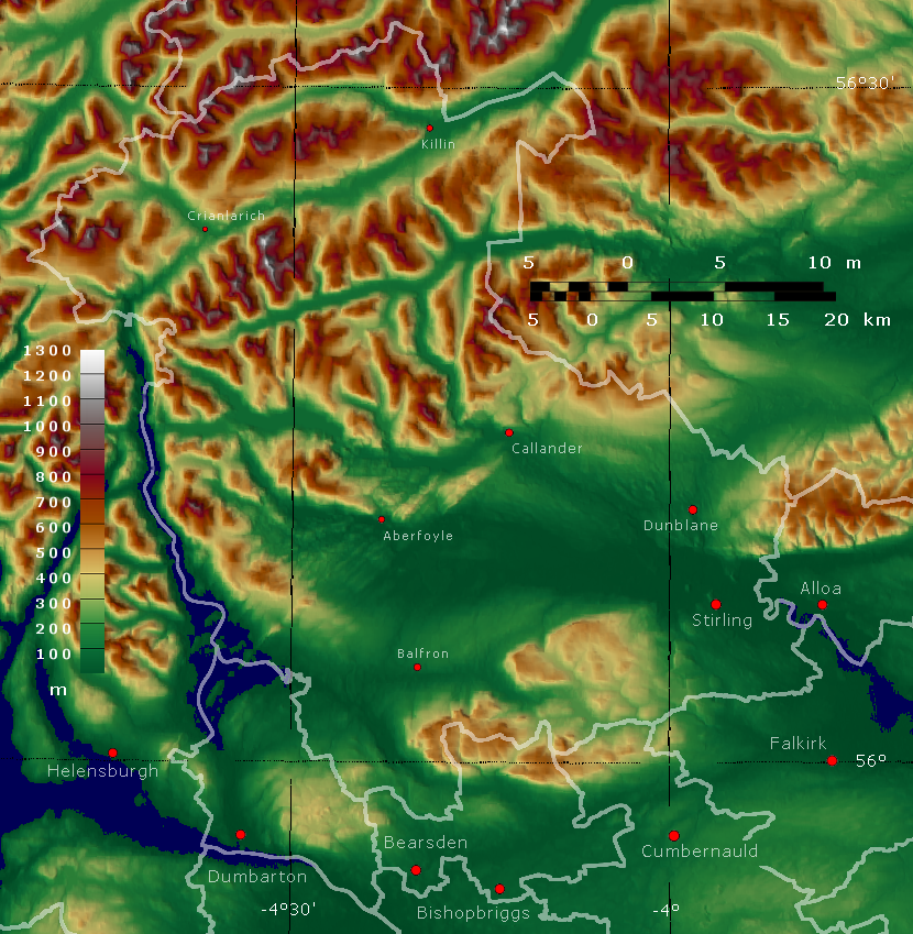
The area borders the council areas of Clackmannanshire (to the east), North Lanarkshire (to the south), Falkirk (to the south east), Perth and Kinross (to the north and north east), Argyll and Bute (to the north and north west), and both East and West Dunbartonshire to Stirling's southwest.
The majority of the population of the area is located in its southeast corner, in the city of Stirling and in the surrounding lowland communities: Bridge of Allan and Dunblane to the north, Bannockburn to the immediate south, and the three former coal mining communities of Cowie, Fallin, and Plean, known collectively as the "Eastern Villages".
The rest of the council area's population is sparsely distributed across the rural, mainly highland, expanse in the north and west of the area. The southern half of this rural area comprises the flat western floodplain of the River Forth, bounded on the south by the Touch Hills and the Campsie Fells. North of the glen lie the Trossachs mountains, and the northern half of the council area is generally mountainous in character.
History
Stirling district was created in 1975 under the Local Government (Scotland) Act 1973, which abolished Scotland's counties, burghs and landward districts and replaced them with upper-tier regions and lower-tier districts. Stirling was one of three districts within the Central region. As created in 1975 the Stirling district covered five districts from Stirlingshire and four districts from Perthshire, which were all abolished at the same time:
From Perthshire:
- Callander Burgh
- Doune Burgh
- Dunblane Burgh
- Western District, except Ardoch (which went to Perth and Kinross)
From Stirlingshire:
- Bridge of Allan Burgh
- Central No. 1 District
- Stirling Burgh
- Western No. 1 District
- Western No. 2 District
The new district and its neighbour Falkirk were together made a new Stirling and Falkirk lieutenancy area. The last Lord Lieutenant of Stirlingshire became the first Lord Lieutenant of Stirling and Falkirk.
Local government was reformed again in 1996 under the Local Government etc. (Scotland) Act 1994, which abolished the regions and districts which had been created in 1975, replacing them with unitary council areas. Central Region was abolished and each of the area's three districts, including Stirling, became council areas. Stirling District Council was therefore replaced by the current Stirling Council.
Demography
Languages
The 2022 Scottish Census reported that out of 90,451 residents aged three and over, 27,348 (30.2%) considered themselves able to speak or read the Scots language.
The 2022 Scottish Census reported that out of 90,449 residents aged three and over, 1,202 (1.3%) considered themselves able to speak or read Gaelic.
Governance
SNP SNP ; Administration (12) : SNP (10) : Green (1) : Independent (1) ; Other parties (11) : Labour (4) :
Political control
The council has been under no overall control since 2007. Following the 2022 election a Labour minority administration formed to run the council. Efforts by the Scottish National Party as the largest party on the council to take over the leadership in February 2025 were unsuccessful, with the council narrowly voting for the Labour minority administration to continue.
The first election to Stirling District Council was held in 1974, initially operating as a shadow authority alongside the outgoing authorities until the new system came into force on 16 May 1975. A shadow authority was again elected in 1995 ahead of the change to council areas which came into force on 1 April 1996. Political control since 1975 has been as follows:
Stirling District Council
| Party in control | Years |
|---|---|
| 1975–1984 | |
| 1984–1988 | |
| 1988–1996 |
Stirling Council
| Party in control | Years |
|---|---|
| 1996–1999 | |
| 1999–2003 | |
| 2003–2007 | |
| 2007–present |
Leadership
The role of provost is largely ceremonial in Stirling. They chair full council meetings and act as the council's civic figurehead. Political leadership is provided by the leader of the council. The first leader of the council, Corrie McChord, had been the last leader of the Central Regional Council. The leaders since 1996 have been:
| Councillor | Party | From | To | ||||||
|---|---|---|---|---|---|---|---|---|---|
| title=The changing face of Scotland | url=https://www.findmypast.co.uk/image-viewer?issue=BL%2F0000540%2F19960327&page=5 | access-date=18 August 2025 | work=The Scotsman | date=27 March 1996 | location=Edinburgh | page=5}} | 1 Apr 1996 | 12 Mar 2008 | |
| title=Council minutes, 12 March 2008 | url=https://minutes.stirling.gov.uk/media/isof0tqf/sc20080312.pdf | website=Stirling Council | access-date=26 August 2025}} | 12 Mar 2008 | May 2012 | ||||
| Corrie McChord | 17 May 2012 | 28 Feb 2013 | |||||||
| title=Council minutes, 28 February 2013 | url=https://minutes.stirling.gov.uk/media/ywmlfkt0/sc20130228.pdf | website=Stirling Council | access-date=26 August 2025}} | 28 Feb 2013 | May 2017 | ||||
| Scott Farmer | 24 May 2017 | May 2022 | |||||||
| Chris Kane | 19 May 2022 | 12 Sep 2024 | |||||||
| Margaret Brisley | 12 Sep 2024 | 27 Oct 2024 | |||||||
| Gerry McGarvey | 6 Feb 2025 | 10 Nov 2025 | |||||||
| Susan McGill | 10 Nov 2025 |
Composition
Following the 2022 election and subsequent by-elections and changes of allegiance, the composition of the council was:
| Date | SNP | Con | Lab | Green | Ind | Vacant | Reason | Leader | Scottish National Party}};" | Scottish Conservatives}};" | Scottish Labour}};" | Scottish Greens}};" | Independent politician}};" | Casual vacancy}};" | ||||||
|---|---|---|---|---|---|---|---|---|---|---|---|---|---|---|---|---|---|---|---|---|
| 5 May 2022 | 8 | 7 | 6 | 1 | 1 | 2022 Stirling Council election | Chris Kane (Lab) | |||||||||||||
| 19 October 2022 | 8 | 7 | 5 | 1 | 2 | Ewan Dillon (Lab) becomes Independent | ||||||||||||||
| 18 December 2022 | 7 | 7 | 5 | 1 | 2 | 1 | Death of Graham Houston (SNP) | |||||||||||||
| 16 March 2023 | 7 | 8 | 5 | 1 | 2 | Robin Kleinman (Con) elected in by-election | ||||||||||||||
| 10 November 2023 | 7 | 7 | 5 | 1 | 2 | 1 | Resignation of Douglas Dodds (Con) | |||||||||||||
| 25 January 2024 | 7 | 8 | 5 | 1 | 2 | Thomas Heald (Con) elected in by-election | ||||||||||||||
| 20 May 2024 | 7 | 8 | 5 | 1 | 1 | 1 | Resignation of Ewan Dillon (Ind) | |||||||||||||
| 15 August 2024 | 7 | 8 | 6 | 1 | 1 | David Wilson (Lab) elected in by-election | ||||||||||||||
| 12 September 2024 | 7 | 8 | 5 | 1 | 1 | 1 | Resignation of Chris Kane (Lab) | Margaret Brisley (Lab) | ||||||||||||
| 27 October 2024 | 7 | 8 | 4 | 1 | 1 | 2 | Death of Margaret Brisley (Lab) | Vacant | ||||||||||||
| 5 December 2024 | 8 | 8 | 4 | 1 | 1 | 1 | Willie Ferguson (SNP) elected in by-election | |||||||||||||
| 23 January 2025 | 9 | 8 | 4 | 1 | 1 | Bob Buchanan (SNP) elected in by-election | ||||||||||||||
| 4 August 2025 | 9 | 7 | 4 | 1 | 1 | 1 | Resignation of Bryan Flannagan (Con) | |||||||||||||
| 30 October 2025 | 10 | 7 | 4 | 1 | 1 | Josh Fyvie (SNP) elected in by-election | Susan McGill (SNP) |
A by-election was held on 15 August 2024 to fill a vacancy caused by the resignation of Ewan Dillon. Following Chris Kane being elected as MP for Stirling and Strathallan, Labour Councillor Margaret Brisley became leader of the Council, but died on 27 October 2024, and a by-election was held to fill the vacancy caused by her death. The next full council election is due in 2027.
Premises
The council is based at Old Viewforth on Pitt Terrace in Stirling. The oldest part of the building is a converted house called Viewforth, which had been built in 1855. The house was bought by Stirlingshire County Council in 1931 for £5,250 and converted to become its headquarters. A large art deco extension was added to the rear of the house, opening in 1937. A new building called New Viewforth was built alongside the older premises in 1972, shortly before Stirlingshire County Council was abolished.
Between 1975 and 1996 the premises at Viewforth served as the headquarters of Central Regional Council, whilst Stirling District Council was based at the Municipal Buildings at 8–10 Corn Exchange Road in Stirling, which had been completed in 1918 for the old Stirling Town Council. On local government reorganisation in 1996 Stirling Council took over Viewforth. The 1972 building known as New Viewforth was demolished in 2014.
Elections
Main article: Stirling Council elections
Since 2007 elections have been held every five years under the single transferable vote system, introduced by the Local Governance (Scotland) Act 2004. Election results since 1995 have been as follows:
| Year | Seats | SNP | Conservative | Labour | Green | Liberal Democrats | Independent / Other | Notes | Scottish National Party}}; width: 3px;" | Scottish Conservatives}}; width: 3px;" | Scottish Labour}}; width: 3px;" | Scottish Greens}}; width: 3px;" | Scottish Liberal Democrats}}; width: 3px;" | Independent politician}}; width: 3px;" | Scottish National Party}}; width: 3px;" | Scottish Conservatives}}; width: 3px;" | Scottish Labour}}; width: 3px;" | Scottish Greens}}; width: 3px;" | Scottish Liberal Democrats}}; width: 3px;" | Independent politician}}; width: 3px;" | ||||||||||||
|---|---|---|---|---|---|---|---|---|---|---|---|---|---|---|---|---|---|---|---|---|---|---|---|---|---|---|---|---|---|---|---|---|
| 1995 | 22 | 2 | 7 | 13 | 0 | 0 | 0 | |||||||||||||||||||||||||
| 1999 | 22 | 2 | 9 | 11 | 0 | 0 | 0 | New ward boundaries. | ||||||||||||||||||||||||
| 2003 | 22 | 0 | 10 | 12 | 0 | 0 | 0 | |||||||||||||||||||||||||
| 2007 | 22 | 7 | 4 | 8 | 0 | 3 | 0 | New ward boundaries. | ||||||||||||||||||||||||
| 2012 | 22 | 9 | 4 | 8 | 1 | 0 | 0 | |||||||||||||||||||||||||
| 2017 | 23 | 9 | 9 | 4 | 1 | 0 | 0 | New ward boundaries. | ||||||||||||||||||||||||
| 2022 | 23 | 8 | 7 | 6 | 1 | 0 | 1 | Labour minority administration with Conservative support. |
Wards
The wards are:
| Ward | ||||
|---|---|---|---|---|
| Number | Ward Name | Location | Seats | |
| 1 | Trossachs and Teith | [[File:Trossachs and Teith.svg | 100px]] | 3 |
| 2 | Forth and Endrick | [[File:Fort_and_Endrick.svg | 100px]] | 3 |
| 3 | Dunblane and Bridge of Allan | [[File:Dunblane and Bridge of Allan.svg | 100px]] | 4 |
| 4 | Stirling North | [[File:Stirling North.svg | 100px]] | 4 |
| 5 | Stirling West | [[File:Stirling West.svg | 100px]] | 3 |
| 6 | Stirling East | [[File:Stirling East.svg | 100px]] | 3 |
| 7 | Bannockburn | [[File:Bannockburn.svg | 100px]] | 3 |
Communities
The area is divided into 42 community council areas, all of which have community councils as at 2023.
- Arnprior
- Balfron
- Balquhidder, Lochearnhead and Strathyre
- Bannockburn
- Braehead and Broomridge
- Bridge of Allan
- Buchanan
- Buchlyvie
- Callander
- Cambusbarron
- Cambuskenneth
- Carron Valley and District
- Causewayhead
- Cornton
- Cowie
- Croftamie
- Drymen
- Dunblane
- Fintry
- Gargunnock
- Gartmore
- Hillpark and Milton
- Killearn
- Killin
- Kilmadock
- King's Park
- Kippen
- Logie
- Mercat Cross
- Plean
- Polmaise
- Port of Menteith
- Raploch
- Riverside
- St Ninians
- Strathard
- Strathblane
- Strathfillan
- Thornhill and Blairdrummond
- Throsk
- Torbrex
- Trossachs
Settlements
As well as the city of Stirling itself, there are many towns, villages and hamlets spread across the council area, as well as dispersed settlements.
Largest settlements by population:
| Settlement | Population () |
|---|---|
| Stirling | |
| Dunblane | |
| Bannockburn | |
| Bridge of Allan | |
| Callander | |
| Fallin | |
| Cowie | |
| Doune | |
| Balfron | |
| Strathblane |
Towns
- Bannockburn
- Bridge of Allan
- Callander
- Doune
- Dunblane
Villages
- Aberfoyle
- Ashfield
- Balfron
- Balmaha
- Balquhidder
- Blairlogie
- Blanefield
- Buchlyvie
- Cambusbarron
- Cambuskenneth
- Cowie
- Crianlarich
- Croftamie
- Deanston
- Drymen
- Fallin
- Fintry
- Gargunnock
- Gartmore
- Killearn
- Killin
- Kinlochard
- Kippen
- Milton of Buchanan
- Lochearnhead
- Plean
- Port of Menteith
- Strathblane
- Strathyre
- Thornhill
- Throsk
- Tyndrum
Hamlets
- Ardchullarie More
- Ardeonaig
- Arnprior
- Auchlyne
- Balfron Station
- Boquhan
- Buchanan Smithy
- Carbeth
- Dumgoyne
- Gartness
- Inverarnan
- Kilmahog
- Kinbuck
- Milton
- Mugdock
- Stronachlachar
Dispersed settlements
- Ardchyle
- Auchtubh
- Blair Drummond
- Brig o' Turk
- Dalmary
- Dalrigh
- Inversnaid
- Rowardennan
- Ruskie
Places of interest
- Carse of Lecropt
- Culcreuch Castle
- Inchmahome Priory (a ruined Augustinian priory on an island in the Lake of Menteith, used as a refuge in 1547 by Mary, Queen of Scots)
- Breadalbane Folklore Centre
- Cambuskenneth Abbey (formerly the seat of the Scottish Parliament)
- Doune Castle
- Dunblane Cathedral
- Falls of Dochart
- Falls of Lochay
- Glen Dochart
- Glenfinlas
- Lake of Menteith
- Lecropt Kirk
- Loch Achray
- Loch Ard
- Loch Earn
- Loch Lomond and the Trossachs National Park
- Loch Katrine (The source of most of the drinking water for the city of Glasgow)
- Loch Rusky
- Loch Venachar
- Moirlannich Longhouse
- Queen Elizabeth Forest Park (run by Forestry and Land Scotland)
- Scottish Institute of Sport (on the grounds of Stirling University)
- Stirling Castle
- The University of Stirling
- The Trossachs
- Wallace Monument
- West Highland Way
References
References
- "Council and committees".
- {{UK subdivision statistics citation
- {{cite legislation UK. (1973)
- {{cite legislation UK. (1975)
- {{cite legislation UK. (1994)
- "Home".
- (18 June 2025). "Update statement regarding Chief Executive".
- (19 May 2022). "Labour administration to lead Stirling Council".
- (19 May 2022). "Labour form minority administration on Stirling Council". BBC News.
- Xander Elliards. (10 November 2025). "SNP seize control of Stirling Council as Scottish Labour ousted". The National.
- "Compositions Calculator". University of Exeter.
- (27 March 1996). "The changing face of Scotland". The Scotsman.
- (11 March 2008). "SNP in shock bid to grasp power". Daily Record.
- "Council minutes, 12 March 2008".
- (10 May 2012). "Labour / Tory deal at Stirling Council ousts SNP". BBC News.
- "Council minutes, 17 May 2012".
- "Council minutes, 28 February 2013".
- (25 April 2017). "Going Local: All change in Stirling as leaders of Labour-Conservative partnership bow out". The National.
- "Council minutes, 24 May 2017".
- (17 May 2022). "Stirling Council: Labour strikes 'grubby' deal with Tories to lock SNP out". The National.
- "Council minutes, 19 May 2022".
- (12 September 2024). "Stirling MP Chris Kane accused of 'double-jobbing' after stepping down as council leader". The Courier.
- "Council minutes, 12 September 2024".
- (12 Sep 2024). "Cllr Margaret Brisley appointed as Stirling Council Leader". Stirling Council.
- (28 October 2024). "Stirling Council leader Margaret Brisley dies aged 79". BBC News.
- "Council minutes, 6 February 2025".
- (12 February 2025). "New Stirling Council leader elected after SNP take over bid fails by single vote". Daily Record.
- (10 November 2025). "SNP take over running of Stirling Council".
- "Stirling Council Leader Margaret Brisley Dies Aged 79".
- "Stirling". Thorncliffe.
- {{Historic Environment Scotland
- (17 January 1931). "New County Buildings". Falkirk Herald.
- (8 May 1937). "New County Buildings opened". Falkirk Herald.
- (4 May 2016). "Viewforth - Council Buildings Old and New".
- {{Historic Environment Scotland
- {{London Gazette. (29 March 1996)
- (11 January 2014). "Former Stirling Council building will vanish within weeks". The Courier.
- {{cite legislation UK. (1998)
- {{cite legislation Scotland. (2006)
- {{cite legislation Scotland. (2016)
- "About Community Councils".
- {{Scottish settlement population citation
This article was imported from Wikipedia and is available under the Creative Commons Attribution-ShareAlike 4.0 License. Content has been adapted to SurfDoc format. Original contributors can be found on the article history page.
Ask Mako anything about Stirling (council area) — get instant answers, deeper analysis, and related topics.
Research with MakoFree with your Surf account
Create a free account to save articles, ask Mako questions, and organize your research.
Sign up freeThis content may have been generated or modified by AI. CloudSurf Software LLC is not responsible for the accuracy, completeness, or reliability of AI-generated content. Always verify important information from primary sources.
Report