From Surf Wiki (app.surf) — the open knowledge base
Stevens Creek (California)
Creek in Santa Clara County, California

Creek in Santa Clara County, California
| Field | Value | |||||||
|---|---|---|---|---|---|---|---|---|
| name | Stevens Creek | |||||||
| native_name | es{{cite book | |||||||
| title | Durham's Place Names of California's San Francisco Bay Area: Includes Marin, San Francisco, San Mateo, Contra Costa, Alameda, Solano & Santa Clara counties | author= Durham, David L. | url= https://books.google.com/books?id=Yfa0hmE7yocC&pg=PA591 | page=707 | publisher= Word Dancer Press, Sanger, California | year=1998 | isbn=1-884995-14-4 | access-date=Jan 1, 2010 }} |
| name_other | Cupertino Creek | |||||||
| image | Steelhead trout digging redd March 2013 Stevens Creek.jpg | |||||||
| image_caption | Steelhead trout and spawning redd on Stevens Creek | |||||||
| map | Stevens creek watershed.jpg | |||||||
| map_size | 250 | |||||||
| map_caption | Stevens Creek watershed (Interactive map) | |||||||
| subdivision_type1 | Country | |||||||
| subdivision_name1 | United States | |||||||
| subdivision_type2 | State | |||||||
| subdivision_name2 | California | |||||||
| subdivision_type3 | Region | |||||||
| subdivision_name3 | Santa Clara County | |||||||
| subdivision_type5 | City | |||||||
| subdivision_name5 | Mountain View, California | |||||||
| source1 | Black Mountain in the Santa Cruz Mountains | |||||||
| source1_location | Monte Bello Open Space Preserve | |||||||
| source1_coordinates | ||||||||
| mouth | Southwest San Francisco Bay | |||||||
| mouth_location | Whisman Slough, Mountain View, California | |||||||
| mouth_coordinates | ||||||||
| mouth_elevation | 3 ft | |||||||
| tributaries_left | Indian Creek (San Leandro River), Bay Creek (San Leandro River), Gold Mine Creek, Swiss Creek, Montebello Creek, Heney Creek |
Stevens Creek is a 20.9 mi stream in Santa Clara County, California. The creek originates in the Santa Cruz Mountains on the western flank of Black Mountain in the Monte Bello Open Space Preserve near the terminus of Page Mill Road at Skyline Boulevard. It flows southeasterly through the Stevens Creek County Park before turning northeast into Stevens Creek Reservoir. It then continues north for 12.5 mi through Cupertino, Los Altos, Sunnyvale and Mountain View before emptying into the San Francisco Bay at the Whisman Slough, near Google's main campus.
History
The creek was originally named Arroyo San José de Cupertino (Spanish for Saint Joseph of Cupertino Creek) by Spanish explorer Juan Bautista de Anza, who camped along the creek on his expedition from Monterey to San Francisco. De Anza completed the first overland route to San Francisco Bay when he and Father Pedro Font sighted the bay from a prominent knoll near the entry of Rancho San Antonio County Park. In de Anza's diary on March 25, 1776, he states that he "arrived at the "Arroyo San José de Cupertino", which is useful only for travelers. Here we halted for the night, having come eight leagues in seven and a half hours. From this place we have seen at our right the estuary which runs from the port of San Francisco." The Diocese of San Jose recently dedicated de Anza's Knoll as permanent public open space.
The Saint Joseph of Cupertino place name is preserved today in the city of Cupertino to the east and in the Saint Joseph of Cupertino Parish Catholic church in the city. The Arroyo San José de Cupertino became Cupertino Creek sometime before 1866, but was later re-named for Elijah Stephens (how his name was misspelled is unknown), a South Carolina-born blacksmith and trapper who settled on Cupertino Creek in 1848. Stephens renamed his 160 acre property at the base of Black Mountain "Blackberry Farm". Stephens is notable for being the captain of the Stephens–Townsend–Murphy Party, the first wagon train to cross the Sierra Nevada (two years before the ill-fated Donner Party).
Watershed
Stevens Creek enters the San Francisco Estuary near Long Point, north of Moffett Field Naval Air Station, at Whisman Slough between Mountain View's Shoreline Park and Stevens Creek Shoreline Nature Study Area. It drains a watershed of about 29 sqmi.
There is one major impoundment (dam), Stevens Creek Reservoir at 531 ft of elevation. The reservoir was constructed in 1935 to provide storage capacity of winter runoff that could be used to recharge the Santa Clara valley aquifer. The reservoir is managed by the Santa Clara Valley Water District (SCVWD) and has a current capacity of 3465 acre.ft of water. As currently managed by the SCVWD, flows are released during summer months which result in maintaining a wet channel for approximately 5.7 mi downstream of the Reservoir (to Fremont Avenue) in order to preserve steelhead.
Tributaries above the Stevens Creek Reservoir include Indian Creek, Bay Creek, Gold Mine Creek, Swiss Creek and Montebello Creek. One tributary, Heney Creek, joins the mainstem 3.7 mi below the Reservoir. Additionally, a diversion channel from Permanente Creek (constructed in 1959) sends winter storm flows into Stevens Creek approximately 6.3 mi below the reservoir.
Stevens Creek Trail

The Stevens Creek Trail is a 5 mi long bicycle and pedestrian path that runs south continuously from Shoreline Park to Heatherstone Way in Mountain View. Cupertino has completed an approximately 1 mi section of trail that runs north along the creek from McClellan Road to Stevens Creek Blvd., passing the 4-H farm and community gardens in McClellan Ranch Park nature preserve, and the Blackberry Farm Park. The trail is entirely separated from vehicular traffic, using numerous overcrossings and underpasses.
The four cities of Sunnyvale, Cupertino, Los Altos, and Mountain View cooperated on potential trail alignments with the goal of a completed trail from the Bay to the Santa Cruz Mountains; they produced a recommendation, which was approved by all four cities, and then disbanded their joint city working team.
Habitat and conservation
Steelhead trout
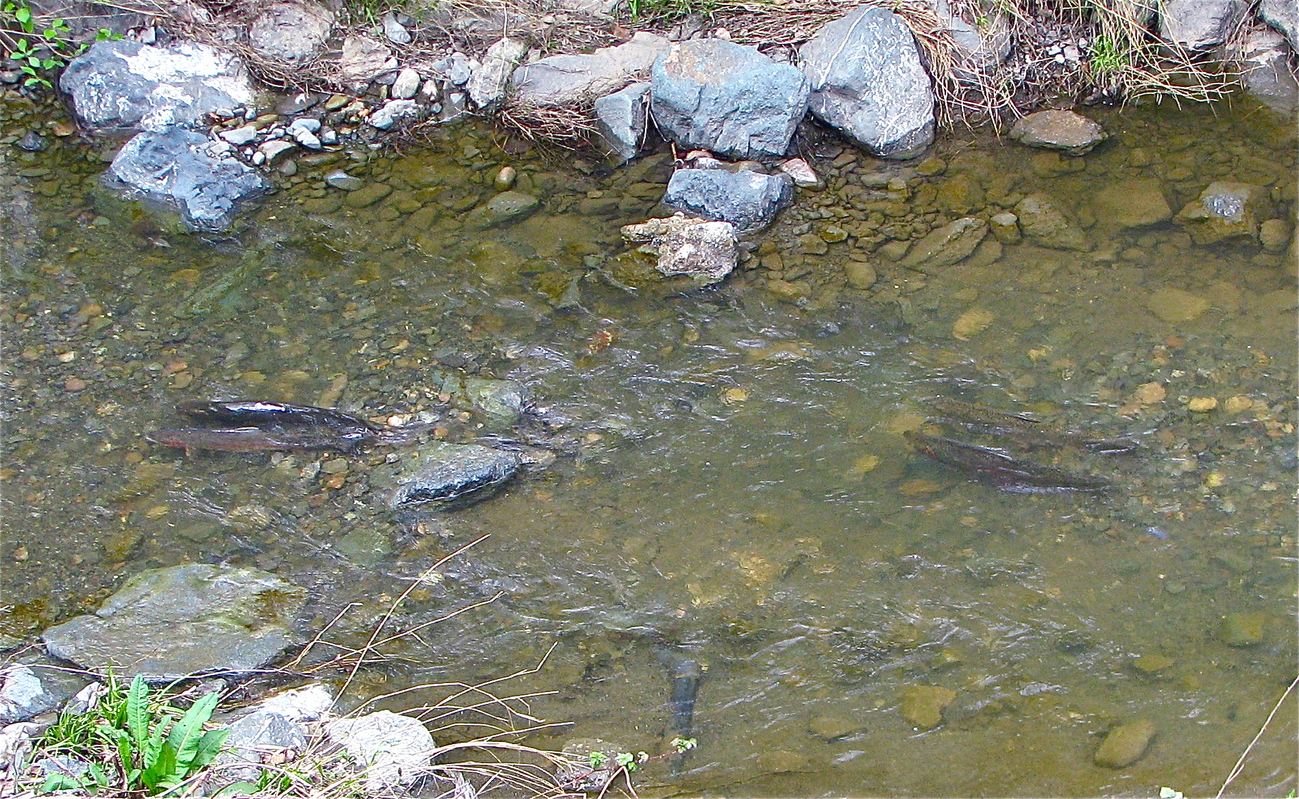


Stevens Creek was one of the prime steelhead (coastal rainbow trout) (Oncorhynchus mykiss irideus) habitats within the county. The Sportsman Gazetteer in 1877 touted Stevens Creek as a trout fishing destination. Six physical specimens were collected in 1893 by Stanford Biology Professor W. W. Thoburn and are in the California Academy of Sciences collection. In 1898 John Otterbein Snyder collected steelhead trout specimens in Stevens Creek. Leidy reviewed numerous historical observer and sampling records of steelhead trout in Stevens Creek throughout the twentieth century and noted that hatchery stock planted in the creek did not seem to survive like the native, wild trout did. In a genetic study of fish from Santa Clara Valley streams, Stevens Creek and other trout had coastal steelhead ancestry and no substantial introgression of hatchery trout. The Stevens Creek fish were closely related to the steelhead trout in nearby basins.
However, there are significant barriers for anadromous steelhead to run up Stevens Creek to spawn. In a 1994 study, the Santa Clara Valley Water District (SCVWD) found fish ladders at the Central Expressway and U.S. Route 101 often had insufficient flow and/or were clogged with debris and sediment. In addition, the drop structure at L'Avenida Avenue was impassable in all five years of the study. In August, 2003 the Stevens & Permanente Creeks Watershed Council was officially formed to support stewardship of the watersheds. The SCVWD's Fish and Aquatic Habitat Collaborative Effort (FAHCE), has recommended removal of the Denil-type fish ladders at Fremont Avenue, Evelyn Avenue, and Moffett Boulevard which tend to clog with debris and are now classified as partial barriers by the California Department of Fish and Game (CDFG). Adjacent to the fish ladder at Moffett Boulevard is a concrete drop structure built in the 1980s which is another obstacle to salmonid passage. The existing concrete-lined channel extending further downstream to Highway 101 (a distance of 450 ft) is flat and low flows cross it as a thin sheet of water over the concrete bottom. At least 6 in depth of flow is required for adequate fish passage. Although steelhead continue to spawn in lower Stevens Creek, it is doubtful whether young trout can oversummer for one to two years in its drier, hotter lower reaches. In addition, if the Permanente Creek Diversion Channel could be modified to accommodate steelhead trout in-migration, then potentially 9 mi of upper Permanente Creek, which currently holds a population of resident coastal rainbow trout, would be available for spawning. Under the water district's Fish and Aquatic Habitat Collaborative Effort (FAHCE), Stevens Creek has been identified as one of the prime steelhead habitats within Santa Clara County and plans are underway to remove three barriers to fish passage in the lower creek: at Moffett Boulevard, Evelyn Avenue and Fremont Avenue.
Stevens Creek Dam blocks 8.6 mi of potential anadromous steelhead trout spawning habitat further upstream.
Red-bellied newt
The red-bellied newt (Taricha rivularis) was thought to occur only in coast redwood (Sequoia sempervirens) forests 130 km north of Stevens Creek in Sonoma County, California, however a disjunct population was discovered in the upper watershed of Stevens Creek that is genetically identical to the Sonoma County population. Whether the Stevens Creek newts were introduced or are a relict population is unclear.
Western burrowing owl

The western burrowing owl (Athene cunicularia) nests at Shoreline Park near the mouth of Stevens Creek. In 2008, Mountain View evicted a pair of burrowing owls so that it could sell a parcel of land to Google to build a hotel at Shoreline Boulevard and Charleston Road. Eviction of the owls is controversial because the birds regularly reuse burrows for years, and there is no requirement that suitable new habitat be found for the owls. Despite being listed in 1979 as a Species of Special Concern (a pre-listing category under the Endangered Species Act) by the California Department of Fish and Game, California's population declined 60% from the 1980s to the early 1990s, and continues to decline at roughly 8% per year. In 1994, the U.S. Fish and Wildlife Service nominated the Western Burrowing Owl as a Federal Category 2 candidate for listing as endangered or threatened, but loss of habitat continues due to development of the flat, grassy lands used by the owl. According to The Institute for Bird Populations at Point Reyes, there has been a 50 percent decline in burrowing owl populations in the Bay Area in the last 10 to 15 years. Their status protects them from disturbance during nesting season or killing at any time, but does not guarantee them a permanent home, as outside of breeding season, owls can be evicted from their homes. A 1992–93 survey reported no breeding burrowing owls in Napa, Marin, and San Francisco counties, and only a few in San Mateo and Sonoma. The Santa Clara County population is declining and restricted to a few breeding locations, leaving only Alameda, Contra Costa, and Solano counties as the remnant breeding range.
Landmark status

On December 23, 1964, the Office of Historic Preservation designated Arroyo de San José Cupertino as a California historical landmark #800. A description on the commemorative plaque reads: "This arroyo honoring San Joseph, patron saint of flight and students, was first discovered and traversed by Spanish explorers in 1769. On March 25-26, 1776, Colonel Juan Bautista de Anza made it his encampment No. 93, as mapped by his cartographer, Padre Pedro Font, on his journey to the San Francisco Bay area where he initiated a colony, a mission, and a presidio."
References
References
- {{Gnis. 1667885. Stevens Creek
- U.S. Geological Survey. National Hydrography Dataset high-resolution flowline data. [http://viewer.nationalmap.gov/viewer/ The National Map] {{webarchive. link. (2012-03-29 , accessed March 15, 2011)
- (1776). "Diary of Juan Bautista de Anza October 23, 1775 - June 1, 1776". [[University of Oregon]] Web de Anza pages.
- "Stevens Creek: Historic, Navigable, Misspelled".
- "Stevens Creek".
- "Stevens Watershed, Santa Clara Valley Urban Runoff Pollution Prevention Program". Santa Clara Valley Urban Runoff Pollution Prevention Program.
- Teater & etc.. (2004). "Map of Shoreline Park and Stevens Creek, Hetch-Hetchy Trails". City of Mountain View.
- (2014-06-27). "Stevens Creek Corridor Park & Restoration Phase 2 Dedication Celebration". City of Cupertino.
- [http://www.cupertino.org/Modules/ShowDocument.aspx?documentid=8526 Stevens Creek Trail Map], City of Cupertino
- (2017-10-28). "Stevens Creek Trail Status". Friends of the Stevens Creek Trail.
- Charles Hallock. (1877). "The sportsman's gazetteer and general guide". "Forest and stream" publishing Company.
- "Oncorhynchus mykiss irideus, SU 4758". California Academy of Sciences.
- John Otterbein Snyder, United States Bureau of Fisheries. (1905). "Notes on the fishes of the streams flowing into San Francisco Bay, California in Report of the Commissioner of Fisheries to the Secretary of Commerce and Labor for the fiscal year ending June 30, 1904". General Printing Office.
- (2005). "Historical Distribution and Current Status of Steelhead/Rainbow Trout (Oncorhynchus mykiss) in Streams of the San Francisco Estuary, California". Center for Ecosystem Management and Restoration.
- John Carlos Garza. (March 2008). "Population genetics of Oncorhynchus mykiss in the Santa Clara Valley Region". Santa Clara Valley Water District.
- (2005). "Historical distribution and current status of steelhead/rainbow trout (Oncorhynchus mykiss) in streams of the San Francisco Estuary, California.". Center for Ecosystem Management and Restoration, Oakland, CA..
- "Stevens Creek and Permanente Creeks Watershed Council: About US".
- (June 2009). "FAHCE Stevens Creek Fish Passage Enhancement Project No. 00294001 Problem Definition/Refined Objectives Report".
- Stillwater Sciences. (2004-09-10). "Stevens Creek Limiting Factors Analysis". SCVURPPP.
- Darren Howe. (2013-04-19). "Stevens Creek Survey and Observations". NOAA/NMFS.
- "Stevens Creek Fish Passage Modifications". Santa Clara Valley Water District.
- (2014). "Discovery of a New, Disjunct Population of a Narrowly Distributed Salamander (''Taricha rivularis'') in California Presents Conservation Challenges". Journal of Herpetology.
- Tony Iwane. (January 3, 2021). "The Mysterious Red Belly. A visit with Stevens Creek's resident enigmas".
- DeBolt, Daniel. (January 10, 2008). "Burrowing Owls vs. Google:Pair of birds found on Google's hotel site will cost city $150,000". Mountain View Voice.
- Rendon, JIm. (Nov–Dec 1999). "Owl Be Damned:Developers plow into the homes of the burrowing owl". Metro, Silicon Valley's Weekly Newspaper.
- Donna Whitmarsh. "Antioch Developer Evicts Burrowing Owls". Bay Nature.
- Joe Eaton. (Jan 14, 2010). "Wild Neighbors: Antioch Owls Face {{as written". Berkeley Daily Planet.
- "Arroyo de San Joseph Cupertino". Office of Historic Preservation.
This article was imported from Wikipedia and is available under the Creative Commons Attribution-ShareAlike 4.0 License. Content has been adapted to SurfDoc format. Original contributors can be found on the article history page.
Ask Mako anything about Stevens Creek (California) — get instant answers, deeper analysis, and related topics.
Research with MakoFree with your Surf account
Create a free account to save articles, ask Mako questions, and organize your research.
Sign up freeThis content may have been generated or modified by AI. CloudSurf Software LLC is not responsible for the accuracy, completeness, or reliability of AI-generated content. Always verify important information from primary sources.
Report