From Surf Wiki (app.surf) — the open knowledge base
Sterling, Colorado
City in Colorado, United States

City in Colorado, United States
| Field | Value | ||||||||||
|---|---|---|---|---|---|---|---|---|---|---|---|
| name | Sterling, Colorado | ||||||||||
| settlement_type | Home rule municipality | ||||||||||
| native_name | |||||||||||
| nickname | A Colorado Treasure | ||||||||||
| image_skyline | Sterling CO main street.jpg | ||||||||||
| image_caption | Main Street in Sterling (2006) | ||||||||||
| image_map | Logan County Colorado Incorporated and Unincorporated areas Sterling Highlighted 0873935.svg | ||||||||||
| map_caption | Location within Logan County and Colorado | ||||||||||
| subdivision_type | Country | ||||||||||
| subdivision_name | United States | ||||||||||
| subdivision_type1 | State | ||||||||||
| subdivision_name1 | Colorado | ||||||||||
| subdivision_type2 | County | ||||||||||
| subdivision_name2 | Logan County | ||||||||||
| subdivision_type3 | City | ||||||||||
| subdivision_name3 | Sterling | ||||||||||
| government_type | Home rule municipality | ||||||||||
| leader_title | Mayor | ||||||||||
| leader_name | Matt Foos | ||||||||||
| leader_title1 | City Manager | ||||||||||
| leader_name1 | Kevin L. Blankenship | ||||||||||
| leader_title2 | Police Chief | ||||||||||
| leader_name2 | Tyson Kerr | ||||||||||
| established_title | Settled | ||||||||||
| established_date | 1868 | ||||||||||
| established_title2 | Platted | ||||||||||
| established_date2 | 1890 | ||||||||||
| established_title3 | Incorporated | ||||||||||
| established_date3 | December 3, 1884 | ||||||||||
| area_footnotes | |||||||||||
| unit_pref | US | ||||||||||
| area_total_km2 | 19.25 | ||||||||||
| area_land_km2 | 19.25 | ||||||||||
| area_water_km2 | 0.00 | ||||||||||
| area_total_sq_mi | 7.43 | ||||||||||
| area_land_sq_mi | 7.43 | ||||||||||
| area_water_sq_mi | 0.00 | ||||||||||
| area_water_percent | 0.0 | ||||||||||
| population_as_of | 2020 | ||||||||||
| population_footnotes | |||||||||||
| population_total | 13735 | ||||||||||
| population_density_km2 | auto | ||||||||||
| population_density_sq_mi | auto | ||||||||||
| timezone | MST | ||||||||||
| utc_offset | −7 | ||||||||||
| timezone_DST | MDT | ||||||||||
| utc_offset_DST | −6 | ||||||||||
| coordinates | |||||||||||
| elevation_footnotes | |||||||||||
| elevation_m | 1181 | ||||||||||
| elevation_ft | 3937 | ||||||||||
| postal_code_type | ZIP code | ||||||||||
| postal_code | 80751 | ||||||||||
| area_code | 970 | ||||||||||
| blank_name | FIPS code | ||||||||||
| blank_info | 08-73935 | ||||||||||
| blank1_name | GNIS feature ID | ||||||||||
| blank1_info | 0202901 | ||||||||||
| blank3_name | Major highways | ||||||||||
| blank3_info | [[File:I-76 (CO).svg | 24px | link=Interstate 76 in Colorado]] [[File:US_6.svg | 24px | link=U.S. Route 6 in Colorado]] [[File:US_138.svg | 24px | link=U.S. Route 138 in Colorado]] [[File:Colorado_14.svg | 24px | link=Colorado State Highway 14]] [[File:Colorado_61.svg | 24px | link=Colorado State Highway 61]] |
| website | City of Sterling |
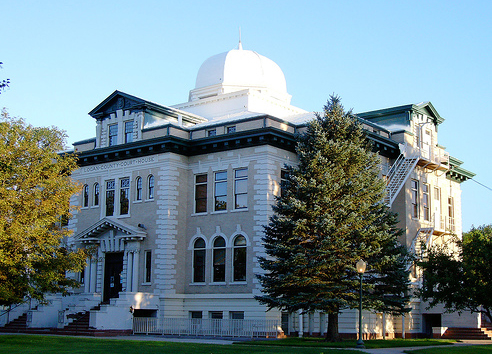
Sterling is a home rule municipality and the county seat and most populous municipality of Logan County, Colorado, United States. The city population was 13,735 at the 2020 census. Sterling is the largest city in the Eastern Plains region of Colorado and the site of the domed Logan County Courthouse, built in 1909. The city is also home to Northeastern Junior College, enrolling over 1,500 students annually.
History
A post office called Sterling has been in operation since 1874. The community was named for Sterling, Illinois, the native home of a railroad official.
Geography
Sterling is 128 mi northeast of Denver, and is located on Interstate 76, on the 'eastern plains' of northeastern Colorado.
According to the United States Census Bureau, the city has a total area of 7.43 sqmi, all land.
Climate
According to the Köppen Climate Classification system, Sterling has a semi-arid climate, abbreviated "BSk" on climate maps.
| access-date = October 22, 2014
Demographics
Sterling is the principal city of the Sterling, CO Micropolitan Statistical Area.
2020 census
As of the 2020 census, there were 13,753 people, 4,604 households, and 2,790 families living in the city. The population density was 1,653.1 PD/sqmi. There were 5,171 housing units at an average density of 752.5 /sqmi. The racial makeup of the city was 90.75% Caucasian American, 0.75% African American, 0.79% Native American, 0.41% Asian, 0.08% Pacific Islander, 5.60% from other races, and 1.62% from two or more races. Hispanic or Latino of any race were 14.20% of the population.
There were 4,604 households, out of which 30.6% had children under the age of 18 living with them, 46.2% were married couples living together, 10.8% had a female householder with no husband present, and 39.4% were non-families. 34.1% of all households were made up of individuals, and 14.7% had someone living alone who was 65 years of age or older. The average household size was 2.34 and the average family size was 3.03.
In the city, the population was spread out, with 25.5% under the age of 18, 12.9% from 18 to 24, 25.5% from 25 to 44, 19.6% from 45 to 64, and 16.4% who were 65 years of age or older. The median age was 35 years. For every 100 females, there were 94.7 males. For every 100 females age 18 and over, there were 91.2 males.
The median income for a household in the city was $27,337, and the median income for a family was $39,103. Males had a median income of $27,921 versus $20,508 for females. The per capita income for the city was $15,287.
Economy

Major employers in Sterling include Northeastern Junior College, the RE-1 Valley School system, and the Sterling Correctional Facility.
Sterling is the major shopping hub for most of northeastern Colorado and hosts big box retailers, as well as many local stores located primarily on Main Street. Six different banks have branches in Sterling and there are local AM and FM radio stations as well as a local television station, and a long-established regional newspaper, the Sterling Journal-Advocate and South Platte Sentinel http://www.southplattesentinel.com.

Government
The Colorado Department of Corrections operates the Sterling Correctional Facility in Sterling.
Education
Sterling is the home of Northeastern Junior College. Sterling is also the location of the RE-1 Valley School District.
Sterling High School on Tiger Avenue and Bengal Boulevard was built in 1958. It originally had grades 10-12, but expanded to include 9th grade in 1974. Building renovations occurred 2006–2007.
Infrastructure
Transportation
Crosson Field serves as Sterling's airport, but there are no scheduled commercial flights available from there. The closest airport served by scheduled flights is Denver International Airport, located 121 mi away.
Sterling is also served by railroads, although only freight carriers serve the town. The main rail operator is Burlington Northern Santa Fe (BNSF), but other operators, like Union Pacific, serve Sterling as well. The closest Amtrak station is located in Fort Morgan, Colorado, about 47 mi away.
Intercity bus service is offered by Burlington Trailways and Express Arrow with service to Denver, as well as a number of cities in Nebraska including North Platte, Kearney, and Omaha. Sterling is also part of Colorado's Bustang network, as the eastern terminus of the Sterling–Denver and Sterling–Greeley routes, which operate two days per week and three days per week respectively.
Highways
- [[File:I-76.svg|25px]] Interstate 76 connects Sterling to Denver (128 mi southwest) and northeast to Interstate 80, in Big Springs, Nebraska, along the South Platte River.
- [[File:Business Loop 76.svg|25px]] Business Loop 76 starts on the intersection of Interstate 76 and US 6, going through East Chestnut Street, North and South 4th Street, South Division Avenue, returning to US 6, connecting Sterling to Atwood and Merino.
- [[File:US 6.svg|25px]] US 6 runs east–west linking Provincetown, Massachusetts with Bishop, California, via Nevada, Colorado, Illinois and 8 other states.
- [[File:US 138.svg|25px]] US 138 Runs parallel to Interstate 76, connecting Sterling to US 30, north of Big Springs, Nebraska.
- [[File:Colorado 14.svg|25px]] State Highway 14 connects Sterling to Fort Collins located 102 mi to the west.
Health care
Sterling is a regional center for health care as well and is the home of Sterling Regional MedCenter (SRMC).
Media
Radio
- KSRX (97.5 FM), Branded as Bob FM, plays "80's, 90's... and whatever!"
References
References
- "Active Colorado Municipalities". [[Colorado.
- "Colorado Counties". [[Colorado.
- (December 1, 2004). "Colorado Municipal Incorporations". [[Colorado.
- "2019 U.S. Gazetteer Files". United States Census Bureau.
- United States Census Bureau. "Sterling city; Colorado".
- "ZIP Code Lookup". [[United States Postal Service]].
- "Find a County". National Association of Counties.
- "Logan County".
- "College Navigator - Northeastern Junior College".
- "Post offices". Jim Forte Postal History.
- Dawson, John Frank. (1954). "Place names in Colorado: why 700 communities were so named, 150 of Spanish or Indian origin". The J. Frank Dawson Publishing Co..
- [http://www.weatherbase.com/weather/weather-summary.php3?s=32057&cityname=Sterling%2C+Colorado%2C+United+States+of+America&units= Climate Summary for Sterling, Colorado]
- "[http://www.doc.state.co.us/facility/scf-sterling-correctional-facility SCF - Sterling Correctional Facility]." [[Colorado Department of Corrections]]. Retrieved on April 19, 2012. "Facility Location: 12101 Hwy 61 Sterling, CO, 80751"
- [https://files-backend.assets.thrillshare.com/documents/asset/uploaded_file/945/Re_1_Valley_School_District/e2c963c2-3991-444f-82e6-961bb230fb61/District_History.pdf?disposition=inline "District History"], RE-1 Valley School District. Retrieved December 10, 2025.
- "Bustang Outrider Schedules & Rates". Colorado Department of Transportation.
- "97.5 Bob FM".
- "BOB FM {{!}} 80s, 90s... and whatever!".
- "FM Station KSRX - FCC Public Inspection File".
This article was imported from Wikipedia and is available under the Creative Commons Attribution-ShareAlike 4.0 License. Content has been adapted to SurfDoc format. Original contributors can be found on the article history page.
Ask Mako anything about Sterling, Colorado — get instant answers, deeper analysis, and related topics.
Research with MakoFree with your Surf account
Create a free account to save articles, ask Mako questions, and organize your research.
Sign up freeThis content may have been generated or modified by AI. CloudSurf Software LLC is not responsible for the accuracy, completeness, or reliability of AI-generated content. Always verify important information from primary sources.
Report