From Surf Wiki (app.surf) — the open knowledge base
Staines-upon-Thames
Town in Surrey, England
_(FindID_84386).jpg)
Town in Surrey, England
| Field | Value | |
|---|---|---|
| type | Market town | |
| official_name | Staines-upon-Thames | |
| country | England | |
| coordinates | ||
| population | 18,484 | |
| population_ref | (2011 Census, traditional boundaries) or 25,736 (Built-up Area, which includes Laleham) | |
| area_total_km2 | 7.86 | |
| <!-- | civil_parish | n/a-- |
| shire_district | Spelthorne | |
| shire_county | Surrey | |
| region | South East England | |
| static_image_name | Staines from the air.jpg | |
| static_image_caption | Staines-upon-Thames (left) and Egham Hythe (right) viewed from the north west | |
| static_image_2 | Staines Old Town Hall, Surrey 3441662147.jpg | |
| static_image_2_caption | Town Hall, Market Square | |
| constituency_westminster | Spelthorne | |
| post_town | Staines-Upon-Thames | |
| postcode_district | TW18-19 | |
| postcode_area | TW | |
| dial_code | 01784 | |
| os_grid_reference | TQ036716 | |
| london_distance_km | 28 | |
| london_direction | ENE |
Staines-upon-Thames, commonly known simply as Staines, is a market town in northwest Surrey, England, around 17.25 mi west of central London. It is in the Borough of Spelthorne, at the confluence of the River Thames and Colne. Historically part of Middlesex, the town was transferred to Surrey in 1965. Staines is close to Heathrow Airport and is linked to the national motorway network by the M25 and M3. The town is part of the Greater London Built-up Area.
The earliest evidence of human activity in the area is from the Paleolithic and, during the Neolithic, there was a causewayed enclosure on Staines Moor. The first bridge across the Thames at Staines is thought to have been built by the Romans and there was a settlement in the area around the modern High Street by the end of the 1st century CE. Throughout the Middle Ages, Staines was primarily an agricultural settlement and was held by Westminster Abbey. The first surviving record of a market is from 1218, but one may have taken place near St Mary's Church in the Anglo-Saxon period.
The industrialisation of Staines began in the mid-17th century when Thomas Ashby established a brewery in the town. Improvements to the local transport network in the mid-19th century also stimulated an expansion of the local population. The current Staines Bridge, designed by George Rennie, was opened in 1832 by William IV and the first railway line through Staines opened in 1848. The town became a centre for linoleum manufacture in 1864, when Frederick Walton established a factory on the site of the 13th-century Hale Mill.
At the end of the 20th century, Staines became infamous as the home town of the fictional film and television character, Ali G. Although many local residents felt that the town's reputation was suffering through its association with the character, Sacha Baron Cohen, the creator of Ali G, praised Staines for being a "lovely, leafy, middle-class suburb... where swans swim under the beautiful bridge". Partly in response to the reaction to the character, Spelthorne Borough Council voted in 2011 to add the suffix "upon-Thames" to the official name of the town.
Toponymy
The earliest document to refer to Staines is the Antonine Itinerary, thought to have been written in the early 3rd century AD, in which the location appears as Pontibus, meaning "at the bridges". The first surviving records of Staines from the post-Roman period are from 1066, when the settlement appears in two separate charters as Stana and Stane.{{refn|The name Stana is also used in 11th and 13th century copies of charters from the mid-9th century, although there is some doubt as to their authenticity. It later appears as Stanis (1167), Stanys (1428), Steynys and Staynys (1535), before the modern spelling "Staines" is first used in 1578. The name derives from the Old English stān, meaning "stone", and may refer to a Roman milestone on the London to Silchester road that survived into the early Anglo-Saxon period.
In order to promote the town's "riverside image" and to distance it from its association with the fictional character, Ali G, Spelthorne Borough Council voted in December 2011 to change its name from "Staines" to "Staines-upon-Thames". The formal renaming ceremony, conducted by the Lord Lieutenant of Surrey, Dame Sarah Goad, took place on 20 May 2012. In a November 2011 public consultation, 428 responses were in favour and 234 opposed,|group=note}} The Royal Mail adopted the new name in mid-2013.
Geography
Location
Staines-upon-Thames is in northwest Surrey, around 17+1/4 mi from Charing Cross, central London. It is close to the borders of Berkshire and Greater London. The town is linked to junction 13 of the M25 by the A30 and to the M3 by the A308. The area surrounding the borough council offices and the magistrates' courts, to the southeast of the town centre, is known as Knowle Green.{{refn|In the 16th century, Knowle Green was part of a 200 acre estate, owned by the Knowles family.
Staines town centre is close to the confluence of the rivers Colne and Thames. A former millstream, known as Sweeps Ditch, ran to the east of the High Street, but much of its course was diverted underground in the 20th century. Severe flooding events have taken place in Staines in 1894, 1947, and 2014.
Topography and geology
Much of the town is built on gravel "islands" that rise above the low-lying floodplains of the Thames and Colne. These gravel deposits have a typical maximum elevation of 14 m above ordnance datum (AOD) and are as little as 0.5 m above the surrounding floodplain. Staines High Street, oriented northeast to southwest, runs across one of these islands to the site of the medieval bridge and was the nucleus of the Roman town. St Mary's Church, on "Binbury island" to the northwest of the centre, is thought to have been the focus of settlement activity in the late-Saxon period. Elevations below 13.5 m AOD were liable to flooding until the early 19th century and many areas of gravel are covered by muddy silts and sands. There are brickearth deposits to the east of the town, along the A30, and outcrops of alluvium to the north and south.
History
Main article: History of Staines-upon-Thames
Early history
The earliest evidence of human activity in Staines is from the Paleolithic. Flint blades, along with reindeer and horse bone fragments, have been found during excavations at Church Lammas, to the west of the town centre.{{refn|Pits, thought to date from the Mesolithic, have been discovered close to the Church Lammas site. A Neolithic causewayed enclosure, about 800 m west of St Mary's Church, was identified by aerial photography in 1959. The site, on a gravel island in the Colne river delta, 16 m AOD, consisted of two concentric, subcircular ditches, with a probable main entrance at the southeastern side. Pottery sherds and worked flints were found on the site, as well as fragments of human bone. Other Neolithic artefacts from the local area include fragments of a jadeite axe, discovered on Staines Moor in the early 1980s, tentatively dated to BCE.
Deverel–Rimbury pottery from the Church Lammas lands indicates that the Staines area was settled in the Bronze Age and a roundhouse from the same period has been identified at Laleham. Two round barrow ring ditches, one of which had a cremation burial at the centre, were found at Knowle Green in 2021. A further ring ditch, around 21 m in diameter, was found during excavations of the Majestic House site, close to the eastern end of the High Street. A Bronze Age field system at Hengrove Farm was also cultivated during the Iron Age, but fell out of use around the start of the Roman period. There is also evidence of an early Iron Age enclosure on Staines Moor and finds from the site include pottery sherds, flints and animal bones, with evidence of burning having taken place there. Since Staines is located on the low-lying floodplain of the Thames, it is likely that historical flooding events have destroyed much of the archaeological evidence of pre-Roman human activity in the town centre.
Roman and Saxon
The Roman road from London to Silchester crossed the Thames in the Staines area. Both the Thames and Colne are thought to have had multiple channels during this period, which may have necessitated the building of more than one bridge. There was a settlement in the area surrounding the modern High Street and, although the date of its foundation is uncertain, the earliest archaeological evidence is from 5496 AD, corresponding to the reign of Nero and the period of the Flavian Dynasty.
By the mid-2nd century, Staines had increased in size and prosperity and the early Romano-British roundhouses had been replaced by stone buildings with flint and rag-stone foundations. Fragments of painted, plastered wall and floors of opus signinum have been uncovered, and the presence of tesserae indicates that at least one building had a mosaic floor. Staines declined towards the end of the 2nd century, possibly as a result of an increased incidence of winter flooding. Nevertheless, Romano-British settlement activity continued until the early 4th century, although the town appears to have been smaller and less important than it had been in the first half of the Roman period.
Following the end of Roman rule in Britain, the main settlement at Staines appears to have shifted from the High Street area to the Binbury area surrounding St Mary's Church.|group=note}} Archaeological evidence, including pits, ditches and pottery sherds suggests that there was a permanent settlement in this area by the mid-Saxon period and there may have been a marketplace at the northern end of Church Street. Staines may have been a fortified burh and the location of a minster church.
For much of the early Saxon period, the Thames through Staines marked the border between Middlesex (to the north) and Surrey (to the south). In the 9th century, the river was used by Danish Viking raiders to travel into the heart of England. In 993, the Norwegian King, Olaf Tryggvason, sailed up the Thames to Staines with a fleet of 93 ships. In 1009, a large army of Vikings attacked Oxford and retreated back along the banks of the Thames, crossing the river at Staines.
Governance
Between 1042 and 1052, Edward the Confessor rebuilt Westminster Abbey as a royal burial church and endowed it with around 60 estates in the south east of England. Staines was one of the properties granted to the Abbey and remained in its possession until the Reformation. In 1086, the manor appears in the Middlesex section of Domesday Book as Stanes. In 1086, the manor had land for 24 ploughs, six mills and woodland for 30 pigs. It provided an annual income of £35 for the Abbey. Since it was relatively close to Westminster, Staines acted as a home farm, providing for the abbot's personal household. and, in 1225, there were 46 burgesses living in the settlement, suggesting that Staines had become an important local centre.
Westminster Abbey was dissolved in 1540 and Staines then became a possession of the Crown, allowing Henry VIII to extend his Windsor hunting grounds further to the east. In 1613, James I granted the manor to Thomas Knyvet, who had arrested Guy Fawkes at the Palace of Westminster eight years earlier. Following Knyvet's death, Staines passed to Sir Francis Leigh and, following the Restoration of the Monarchy, it was held briefly by Sir William Drake. The manor was then purchased by Richard Taylor, whose descendants lived at Knowle Green until the 19th century.
Reforms during the Tudor period reduced the importance of manorial courts and the day-to-day administration of towns such as Staines became the responsibility of the vestry of the parish church. The vestry appointed a constable, distributed funds to the poor and took charge of the repair of local roads. From the 17th century, the roles of Justices of the Peace were expanded to take greater responsibility for law and order in Staines.
The modern system of local government began to emerge during the 19th century. The Poor Law Amendment Act 1834 transferred responsibility for poor relief to the Poor Law Commission, whose local powers were delegated to the newly formed poor law union in 1836.{{refn|The Staines Poor Law Union was responsible for administering poor relief in 12 parishes in west Middlesex.

Further reorganisation of the local authorities took place in the second half of the 20th century. Under the London Government Act 1963, Middlesex County Council was disbanded and the Staines UDC area was moved into Surrey. The Local Government Act 1972, which came into force on 1 April 1974, merged the Staines and Sunbury-on-Thames UDCs to form the Borough of Spelthorne.
Staines Bridge
Main article: Staines Bridge
The first surviving mention of a bridge from the medieval period is a document from 1222, that authorises repairs using wood cut from Windsor Forest. In around 1250, a causeway was constructed at Egham Hythe to improve the southern approach to the crossing.{{refn|It has been suggested that the Egham Hythe causeway may have originally been built by the Romans and that the work in the mid-13th century was a repair or extension, rather than a new construction.
The bridge was destroyed in the Civil War and was not rebuilt until the 1680s. In 1734, an Act of Parliament noted that the structure was "in a ruinous and dangerous condition" and that the money raised from tolls and local taxes was insufficient to fund adequate maintenance. In the late 18th and early 19th centuries, there were four attempts to construct a new bridge. The first, designed by Thomas Sandby, was opened in 1796, but was closed two years later after cracks started to form in the stonework. A cast-iron replacement, designed by James Wilson in consultation with George Rennie was opened in 1803, but cracked within two months. A third bridge was authorised by Act of Parliament in 1804. It was designed by Rennie and was constructed of timber, strengthened with cast iron plates. Although it did not suffer from the problems of the previous two bridges, it was costly to maintain (£11,000 in 1827) and restricted the width of boats passing beneath it.

A further Act of Parliament in 1828, authorised the borrowing of up to £60,000 for the construction of a fourth bridge. The granite structure was designed by George Rennie and was based on Waterloo Bridge. Rennie insisted that the site of the crossing be moved upstream, where deeper foundations could be constructed. The repositioning required new approach roads to be constructed and the necessary land was subject to compulsory purchase. and William IV opened the bridge in April 1832. Tolls for crossing the bridge were abolished in 1871.
Transport and communications

The earliest locks on the upper Thames were built in the 17th century, following the establishment of the Oxford-Burcot Commission. However, efforts to improve the stretch of the river through Staines did not start until the 19th century. The pound lock at Penton Hook, a tight meander downstream of Staines, was constructed in 1815, but the weirs were not added until 1846.|group=note}} Bell Weir Lock, upstream of the town, opened in 1818, but was rebuilt in 1867-8 after the chamber walls had collapsed the previous year. The construction of the locks regulated the flow of the river and increased its depth to facilitate navigation, whilst maintaining an adequate head of water to power mills.
With the exception of the construction of the causeway at Egham Hythe in the mid-13th century, there were few improvements in the local road network in the millennium following the end of the Roman period. In 1727, the turnpike road from Hounslow to Bagshot, which crossed the river via Staines Bridge, was opened. A second turnpike, from Staines to Kingston opened in 1773. The re-siting of the bridge by George Rennie in the early 1830s necessitated changes in the road network at the western end of the High Street: The Market Square became a no through road and Clarence Street was constructed to direct traffic to the new crossing.
The railway line through Staines between Richmond and was opened by the Windsor, Staines and South Western Railway on 22 August 1848. In 1856, became a junction when the line across the Thames to Ascot was opened. A curve linking the Ascot and Datchet lines was opened in April 1877 and remained in use until March 1965. A second station in the town, Staines High Street station, to the northwest of the junction of this curve and the Datchet line, was open between 1884 and 1916. The railway line through Staines to Windsor was electrified in June 1930 and to in 1937. Staines signal box closed in September 1974.
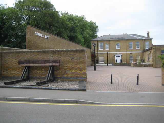
A third station in the town was opened on 2 November 1885. was the terminus of a single-track branch from the Great Western Main Line, constructed by the Staines and West Drayton Railway Company. Originally the intention had been to create a junction with the line from Datchet and for trains to serve the main Staines station, but inter-company rivalry meant that a separate facility was built instead. The freight yard closed in the 1950s and passenger services ceased in March 1965. Trains continued to run to the Staines fuel yard, at Staines West, until the early 1990s.
During the second half of the 20th century, there were large-scale improvements to the road network around Staines. The A30 bypass was constructed in the early 1960s and included the building of Runnymede Bridge over the Thames.{{refn|The A30 Runnymede Bridge was designed by Edwin Lutyens in 1939. The original design was modified to use a single 173.5 ft arch across the main river channel, before construction began in the 1960s. The Chertsey to Staines stretch of the M25 was opened in November 1981 with three lanes in each direction, but with a wide central reservation, allowing the road to be widened easily later. Four lanes in each direction were provided from outset between the A30 and the M4.
.jpg)
The Staines air disaster occurred on 18 June 1972, when a Hawker Siddeley Trident, operated by British European Airways, crashed shortly after takeoff from Heathrow Airport. All 118 people aboard the aircraft, including the six crew members, were killed. Two memorials to all the victims were dedicated on 18 June 2004 in Staines. The first is a stained-glass window in St Mary's Church where an annual memorial service is held on 18 June. The second is a garden near the end of Waters Drive in the Moormede Estate, close to the accident site.
Commerce and industry
The first record of a market at Staines is from 1218, when the Sheriff of Middlesex was ordered to change the day on which it was held from Sunday to Friday. It had been discontinued by 1862, but re-established ten years later when the Town Hall was built. In 2022, the market is held in the High Street on Wednesdays, Fridays and Saturdays. An annual fair to be held in the settlement was granted to Westminster Abbey by Henry III in 1228. Initially it took place over four days at Ascensiontide, but the dates were changed to 7–10 September in 1241. The fairs were abolished in 1896 by the Home Secretary at the request of the Staines UDC.

Domesday Book records six mills in Staines in 1086, First recorded in 1682, Pound Mill was also on the Wraysbury River. It was bought by John Finch in 1747 and was a flour mill until the early 19th century, when it was used to grind mustard. The mill is immortalised in the road name, "Mustard Mill Road".
Hale Mill, on the main channel of the Colne, is thought to have its origins in the 13th century, but it was rebuilt in 1388 and became a fulling mill in the 15th century. Many of the mills in the local area were purchased in the second half of the 18th century by Thomas Ashby, a miller originally from Maidenhead. Ashby founded a brewery, subsequently taken over by his sons, which became a major employer in the town. Brewing ceased in Staines in the 1950s, but bottling continued at the plant until the 1970s.

Staines became a centre for linoleum manufacture in 1864, when Frederick Walton, the inventor, opened the first factory to produce the floor covering on the Hale Mill site, to the north of the town centre. At its height in the 1920s, the Staines plant covered 20 ha and was one of twenty producers in Great Britain. Following the end of the Second World War, there was a decline in lino sales as vinyl floor coverings became more popular. The Staines lino factory closed in 1973.
The Elmsleigh Shopping Centre was opened by Elizabeth II on 22 February 1980, providing 250,000 sqft of retail space. Much of the High Street was pedestrianised in 2002 and the Two Rivers Shopping Centre, on the site of the old linoleum works, was opened in 2002.
In the 21st century, proximity to London, Heathrow Airport and the M25 motorway has attracted large company branch offices, including: Bupa (healthcare) and Wood plc (oil & gas). Siemens Building Automation Division and British Gas (part of Centrica) have their national headquarters here. Samsung R&D Institute UK (SRUK), Samsung's UK R&D division, is based in the town.
Residential development
The modern settlement of Staines appears to have originated in the late 12th century, when the area around the High Street was developed as a planned town, possibly in response to rebuilding the bridge over the Thames. The medieval street plan was not altered until the re-siting of the bridge in the 1830s, at which point the urban area began to spread beyond the confines of the gravel islands.
The population of Staines grew from 1,750 in 1801 to 2,487 in 1841 and 4,638 in 1881. The increase in the second half of the 19th century was stimulated in part by the arrival of the railway in 1848. Cottages for artisans and semi-skilled workers began to spread along the London and Kingston Roads from the mid-19th century onwards. Following the Second World War, there were new housing developments on Commercial Road and between Kingston Road and Elizabeth Avenue, primarily to provide accommodation for workers at the rapidly expanding Heathrow Airport.
Staines in the Second World War
Despite its proximity to London and the fact that Staines Bridge and the local factories presented obvious enemy targets, the town sustained relatively little bomb damage during the Second World War. Within the Staines Urban District, a total 71 civilians died as result of enemy action. The Lagonda works at Egham Hythe were converted to the manufacture of munitions and the linoleum factory was dedicated to making military supplies.
Much of the civil defence effort was focused on the defence of Staines Bridge and tank traps were installed at each end. The Bailey bridge remained in use for pedestrians until 1959, when it was dismantled.
National and local government
UK parliament
The town is in the parliamentary constituency of Spelthorne, and has been represented by Conservative Party MP Lincoln Jopp since 2024. From 2010 until the 2024 general election, Staines was represented at Westminster by Conservative Kwasi Kwarteng. Kwarteng was Chancellor of the Exchequer for 38 days during the 49 day premiership of Liz Truss.
County council
Councillors are elected to Surrey County Council every four years. The majority of the town is in the Staines electoral division, but areas to the southeast of the centre are in the Staines South and Ashford West electoral division.
Borough council
Staines is divided between three wards, each of which elects three councillors to Spelthorne Borough Council. The wards are Staines, Staines South, and Riverside and Laleham. The Borough of Spelthorne has been twinned with Melun, France since 1990 and with Grand Port, Mauritius since 2009.
Demography and housing
| Output area | Population | Households | % Owned outright | % Owned with a loan | hectares |
|---|---|---|---|---|---|
| Staines (ward) | 7,861 | 3,528 | 24.0% | 33.8% | 550 |
| Staines South (ward) | 7,123 | 2,899 | 29.9% | 37.7% | 131 |
| Spelthorne 009B (riverside north) | 1,818 | 862 | 37.6% | 37.5% | 35 |
| Spelthorne 009C (riverside south) | 1,662 | 723 | 51.5% | 39.1% | 70 |
| Regional average | 35.1% | 32.5% |
| Output area | Detached | Semi-detached | Terraced | Flats and apartments | Caravans/temporary/mobile homes | shared between households |
|---|---|---|---|---|---|---|
| Staines (ward) | 387 | 844 | 843 | 1,439 | 2 | 13 |
| Staines South (ward) | 197 | 1,505 | 702 | 492 | 1 | 2 |
| Spelthorne 009B (riverside north) | 174 | 225 | 93 | 365 | 0 | 5 |
| Spelthorne 009C (riverside south) | 369 | 96 | 109 | 148 | 1 | 0 |
Across the South East Region, 28% of homes were detached houses and 22.6% were apartments.
Public services
Utilities
The first drinking water supply to Staines was provided by the West Surrey Water Company, whose works at Egham were built in 1889. Between 1960 and 1973, the company merged with its neighbours serving Woking and south west London, to form the North Surrey Water Company.{{refn|The water stored by the reservoirs to the north of Staines is used to supply London and not the Borough of Spelthorne.
Until the start of the 20th century, wastewater from Staines was discharged directly into the River Thames. Construction of the sewerage system began in 1899. The works closed in 1936, when the town sewers were connected to Mogden Sewage Works in Isleworth.
The Staines and Egham Gas Light and Coke Company was formed in 1834. It began to supply gas from its works in Bedfont Lane in Egham Hythe to the streetlamps on Staines Bridge in February of that year and the gas main to Staines was laid in 1835.
The first electricity generating station serving Staines opened in Egham High Street in 1905. It operated until 1912, when it was replaced by at new facility on The Causeway in Egham Hythe. The new works opened with an installed capacity of 188 kW and, by the time of its closure in 1924, it was capable of generating 688 kW.
Emergency services and justice
The earliest record of a permanent fire-fighting force in Staines is from 1738, when a hand-operated fire pump was purchased for the brigade. Reforms in 1774 transferred responsibility for fire services to the local authority and, in 1800, a new manual fire engine was purchased by the Staines force. The Staines UDC purchased the first diesel engine for the brigade in 1926, which was replaced by a Leyland terrier pump escape engine in 1935. Middlesex County Council took over responsibility for local fire services on 1 April 1948, building a new fire station at Stanwell and closing the Staines station in 1962. Surrey County Council became the fire authority for the local area in 1965.

The first surviving record of a town gaol in Staines is from 1274 and the erection of a new pillory and ducking stool is described in 1335. There were stocks in the Market Square through the 16th century until at least 1790. The vestry appointed the town Constable from the early 15th century until 1840, when responsibility for law enforcement was passed to the Metropolitan Police. In 1865, the police station moved to Kingston Road, later the site of the candle factory. and moved again to new premises on the same street in 1998. In 2022, the local police force is Surrey Police.
The magistrates' courts at Knowle Green, opposite the Spelthorne Borough Council offices, were opened in 1976.
Healthcare
Staines Cottage Hospital was opened on 19 May 1914 on the corner of Kingston Road and Worple Road. It was renamed Staines Hospital in 1933, but its importance decreased following the opening of Ashford Hospital in 1939. During the 1960s, the men's wards were shut and it became a hospital for female patients only. It closed in the early 1980s and the buildings were demolished in 1986. The Kingscroft respite service for adults with learning difficulties opened on the site in 1987.
The nearest hospital with an A&E is St Peter's Hospital, 3.9 mi from Staines-upon-Thames. As of 2022, the town has GP practices at Burgess Way, Knowle Green and on Rochester Road.
Transport
Bus
Staines is linked by a number of bus routes to surrounding towns and villages in north Surrey, south west London (including Heathrow Airport) and east Berkshire. Operators serving the town include London United, First Berkshire & The Thames Valley and White Bus Services. The bus station is to the south of the Elmsleigh Centre.
Train

Staines railway station is to the east of the town centre. It is managed by South Western Railway, which operates all services. Trains run to via , to via Ascot and to via .
River navigation
The non-tidal section of the River Thames is navigable between Lechlade in Gloucestershire and Teddington Lock. The navigation authority is the Environment Agency.
Long-distance cycle route and footpath
National Cycle Route 4, which links London to Fishguard, passes through Staines. The Thames Path crosses Staines Bridge.
Education
Early schools

The surviving first record of a schoolmaster in Staines is from 1353 and there are mentions of later postholders in documents dating from 1580 to 1673. However, by the 18th century, it appears that there was no dedicated teacher living in the town and, in 1795, the parish clerk was in receipt of a modest salary to teach four children. The British Boys' School in Staines was founded in 1808 and the girls' school was in existence by 1832. By 1852, the boys' school was in Hale Street and was educating around 35 pupils. An infants' school was founded in 1833, which moved with the girls school to Thames Street in 1867. National Schools for boys and girls were established in 1818 and in the mid-1820s respectively, but both closed for around a decade before reopening in the mid-1840s. The girls' school moved to new premises in Bridge Street in 1850 and the boys' school relocated to London Road in 1863.
Maintained schools
Riverbridge Primary School was formed from the merger of three predecessor schools in September 2011. The oldest was Shortwood Infant School, which opened in 1905 as the Stanwell Road School. Knowle Park School opened in 1974, but had its origins in the Wyatt Road School which was formed in 1896. Kingscroft Junior School opened in 1992 and replaced Kingston Road School, which had opened in 1903. The school became part of the Lumen Learning Trust in Autumn 2016.
Our Lady of the Rosary Catholic Primary School was founded in 1893.
The construction of the Matthew Arnold School started in 1939, but work was suspended at the outbreak of the Second World War. However, parts of the building were sufficiently close to completion to allow pupils aged 11 to 14 from Kingston Road School to transfer to the site, after their classrooms were damaged by bombing. The school formally opened in 1954.
Independent school
Staines Preparatory School was founded by Cyril Travers Burges and opened on 8 May 1935. The original premises were at 1 Gresham Road, but the school moved to number 3 in 1938 and expanded to number 5 in 1951. The Burges Wing was constructed in 1991; the Jubilee Wing was built in 2002, and was extended in 2008. Today, Staines Prep School educates boys and girls between the ages of 3 and 11.
Places of worship
St Mary's Church
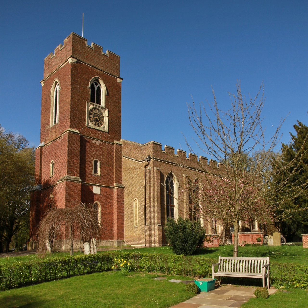
Main article: St Mary's, Staines
St Mary's Church is first recorded in 1179, but it is thought to have been in existence for at least 100 years before that. There is no mention of a church in Domesday Book, By the end of the medieval period, St Mary's had a chancel, nave and an aisle on the north side. It was primarily built of brick in the Gothic style and the tower at the west end was added in 1631.
The condition of the church deteriorated in the late 17th and 18th century, due in part to the sale of the lead from the roof of the aisle to fund the Parliamentarian cause in the Civil War. The north side of the building collapsed in 1827 and a new church was built in 1828–9, incorporating the 17th-century tower. Among the stained glass panels in the church is a window behind the altar, given by the Crown Prince and Crown Princess of Prussia. In 2005, a window was dedicated to those who died in the 1972 Staines air disaster.
St Peter's Church

St Peter's Church was founded as a chapel of ease to St Mary's in 1874. A brick building was constructed at the corner of Wyatt and Langley Roads and was used until 1885, when the congregation moved to an iron church on the corner of Edgell and Budebury Roads.
The foundation stone for the current St Peter's Church was laid on 22 July 1893 and the building was consecrated on 28 July the following year. It was designed by George Fellowes Prynne in the free Perpendicular style and the cost of construction was paid by the Solicitor General, Edward Clarke MP. The crenellated tower is topped with a set-back spire, and contains a ring of eight bells.
Christ Church

The first Christ Church, in Kenilworth Gardens, was constructed in 1935 to serve the new area of housing along Kingston Road to the southeast of the town centre. The brick building was able to accommodate 280 worshippers, and a sliding partition at the west end of the chancel allowed the nave to be used as a church hall. The parish of Christ Church was created in 1951 and a decade later construction of a new church began on the same site as the old. The new Christ Church, consecrated in October 1962, has a centrally placed altar positioned beneath a square lantern. The lantern allows natural light into the interior of the building and is topped with a narrow spire. The font, which dates from 1750, was given to the congregation in 1935, and was previously installed in St Mary's Church.
Staines Methodist Church
John Wesley made his first visit to Staines in 1771 and, by the early 19th century, there was a small congregation of Methodists in the town. The first chapel, opened on Kingston Road, was replaced by a larger building on the same street in 1865. The congregation moved to the current church, on Thames Street, in 1987.
Our Lady of the Rosary
.jpg)
The first Roman Catholic Mass to be celebrated at Staines since the Reformation, took place in 1862 at the workhouse, on the site of the present Ashford Hospital. A chapel was opened in 1890 on Gresham Road and was initially known as "Our Lady, Help of Christians". The current name, "Our Lady of the Rosary" was granted in 1893. The building was extended eastwards to form the present church in 1931, with the addition of a chancel and narrow south aisle. Renovation work in 1990, added additional side aisles and created a new church hall at the west end.
Staines Congregational Church
There has been a substantial population of Dissenters living in Staines since the mid-17th century and, by 1690, there was a permanent meeting house in the town. and was replaced by a classical-style church on the same site in 1837. The present Congregational Church, on Kingston Road, opened in May 1956.
Culture
Art
Several artists have been inspired to paint Staines Bridge, including William Bernard Cooke (17781855) and Arthur Melville (18551904). An engraving of the bridge by William Woolnoth (17801837), inspired by a painting by John Preston Neale (17801847), is held by the Victoria and Albert Museum.
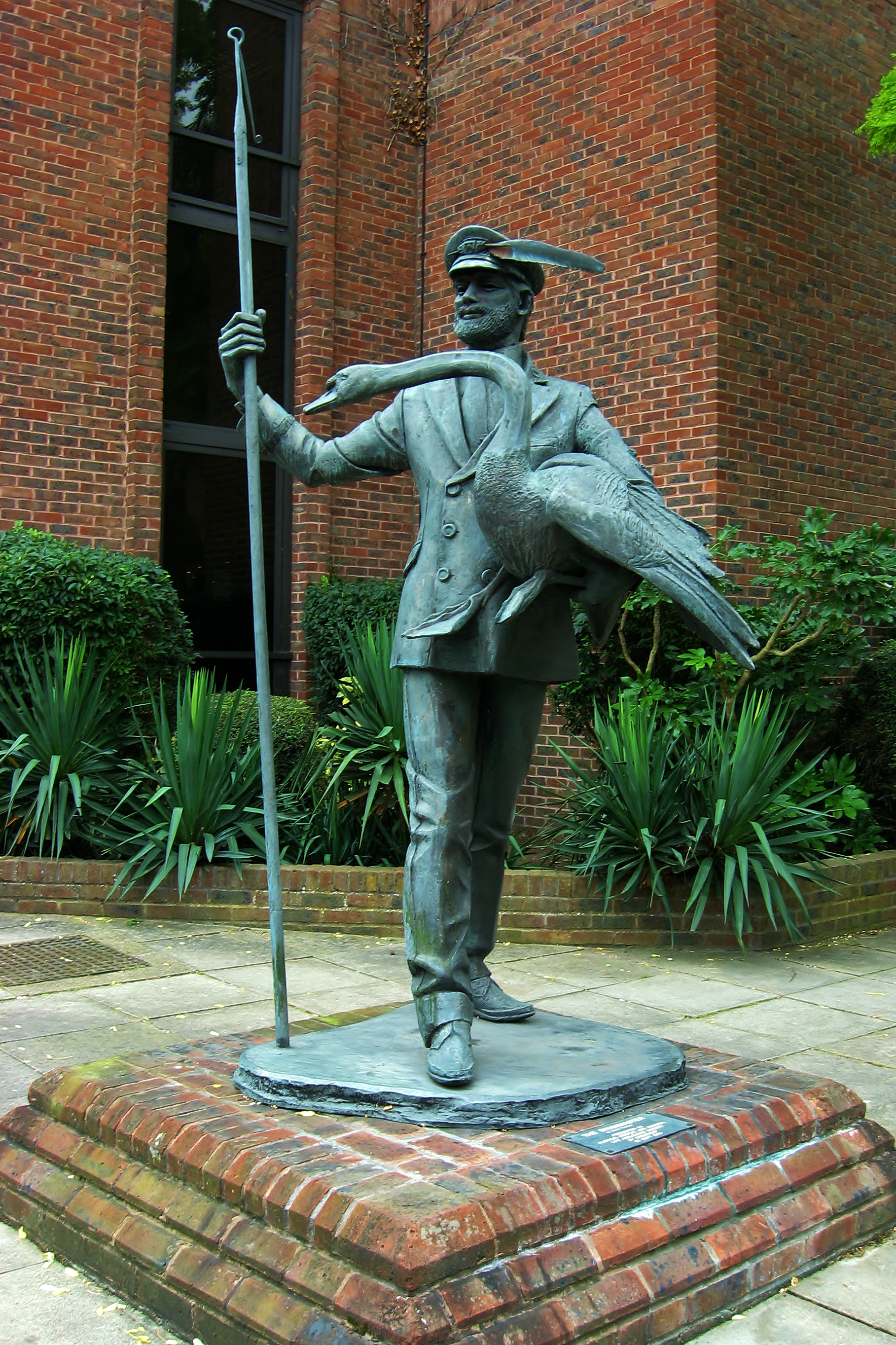
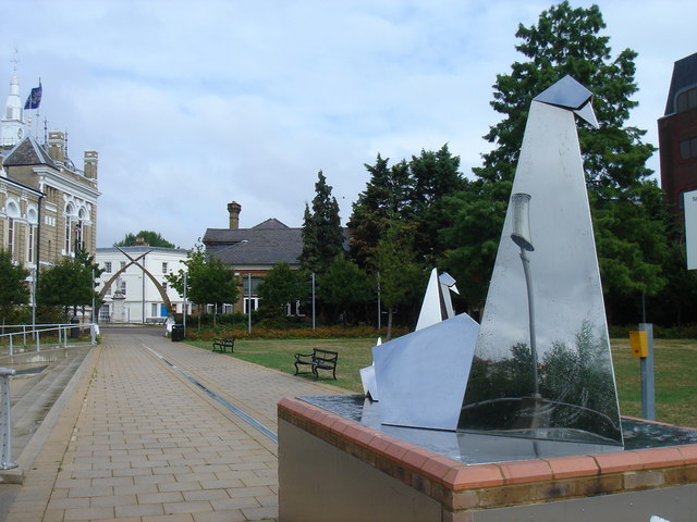
Among the works of public art on display are mosaics by Gary Drostle and sculptures by Terence Clarke that pay homage to the town's history as a former Roman settlement. The Two Rivers shopping centre has two bronze sculptures by David Backhouse: The first, Time Continuum, celebrates the life of Staines through two millennia and the second, Water Sprites, references the life of the waterways that converge nearby. The Swanmaster, by Diana Thomson, commissioned by Spelthorne Borough Council in 1983, was moved to the Memorial Gardens in 2014.
Film and television
Staines is the hometown of the fictional Ali G, created by the actor and comedian Sacha Baron Cohen. The character, who first appeared on The 11 O'Clock Show on Channel 4 in 1998, has been described as a "disaffected wannabe homeboy of the suburbs" by the television producer, Harry Thompson. Baron Cohen has said that Ali G "believes that he is a black hip-hop artist from Staines. He believes his neighbourhood is a rough ghetto, when in fact it's this lovely, leafy, middle-class suburb outside Windsor, where swans swim under the beautiful bridge." Following the successful spin-off television series Da Ali G Show, the character appeared in the 2002 feature film Ali G Indahouse. In the film, Ali G is a member of a fictional gang, the West Staines Massive, when his hometown is threatened by the expansion of Heathrow Airport. The film concludes with the saving of Staines and the decision to demolish Slough instead.
Literature
William Shakespeare mentions Staines in Act II Scene 3 of Henry V, when the Hostess asks her husband, who is travelling to Southampton, if she can accompany him as far as the town. Much of chapters 911 of Three Men in a Boat (1889) by Jerome K. Jerome is set in the Staines area, as the main characters travel upriver from Kingston-upon-Thames to Oxford. In Chapter 15 of H. G. Wells' novel The War of the Worlds (1897), an artillery unit engages a Martian close to Staines. In John Wyndham's novel The Kraken Wakes (1953), the main characters are stopped in their attempt to reach Cornwall on a dinghy through a flooded England in the "Staines-Weybridge area".
Music
The indie rock band Hard-Fi was formed in Staines in 2003. Many of the songs from their first album, Stars of CCTV, describe their small-town suburban origins. In 2011, lead singer Richard Archer attracted criticism after describing Staines as a "ghost town".
Sport
Leisure Centre
Spelthorne Leisure Centre, at Knowle Green, opened in 1990 on the site of the former indoor swimming pool which was constructed in 1967. A new leisure centre, which will provide a 25 m pool, a fitness suite and three artificial football pitches on its roof, is expected to open in 2024.
Association football
Staines Town F.C. (STFC) traces its origins to a football team from St Peter's Institute, which took part in the 1878–79 FA Cup. STFC itself was founded in 1892 and initially played its home games at Hammond's Farm, now beneath the King George VI reservoir. It later merged with the St Peter's team, but the combined club closed in 1935. STFC was reformed towards the end of the Second World War and played its home games at Wheatsheaf Park.
Staines Lammas F.C. was founded in 1926 and initially played its home games at the Lammas Recreation Ground. The club moved to Laleham Recreation Ground in the 1980s and, in 2001, opened a new pavilion.
Cricket
Cricket has been played on Staines Moor since at least 1759 and the nearby Laleham Burway was the site of the first recorded 11-a-side match in Surrey in 1778. Laleham Cricket Club was founded over 200 years ago. It changed its name to the Staines and Laleham Cricket Club in the early 1970s, when it moved from Ashford Road to its current ground, "The Faulkners", on Worple Road.
Hockey
Staines Hockey Club was formed in 1890 and is one of the oldest hockey clubs in the world. During its early years, the club had several international players among its members, who won gold medals at the 1908 Olympic Games. The club has been based at Worple Road since 1972 and the ground has four full-size hockey pitches. The first ladies' team was formed in 1979 and the first artificial turf pitch was laid in 2001.
Rugby
Staines Rugby Football Club was founded in summer 1926 and played its first game against a team from Windsor at the Lammas Recreation Ground that October. In 1947, the club began to rent pitches at the Laleham Cricket Club ground in Ashford Road. It acquired the land for its current premises, a former gravel pit in Hanworth, in 1962. The ground, known as "The Reeves", opened in September 1964.
Rowing
Staines Boat Club was formed in 1851 and, in 1909, was one of the founder members of the Remenham Club. The current boathouse, at Egham Hythe, is a temporary structure, built in 1950 after the previous building was destroyed by fire.
Staines Stadium
Main article: Staines Greyhound Stadium
Staines Stadium, on Wraysbury Road, was opened in 1928 and was primarily used for greyhound racing. Stock car racing took place at the venue in the late 1950s. The stadium closed in 1960, when the A30 Staines bypass was constructed through part of the site, and was demolished in 1965.
Notable buildings and landmarks
Blue Anchor

There is thought to have been an inn on the site of the Blue Anchor since the 16th century. The present building dates from the early- to mid-18th century and is constructed in brick. Much of the interior is thought to be original, including the wooden panelling, several fireplaces and at least one of the staircases. Within a few decades of completion, five of the upstairs windows had been bricked up to reduce window tax liability.
Coal Tax posts
There are three surviving coal-tax posts in the Staines area. These posts marked the limits of the tax jurisdiction of the Corporation of the City of London and were erected under the provisions of the London Coal and Wine Duties Continuance Act 1861. The two posts currently on Wraysbury Road were relocated to their present positions in the second half of the 20th century. The third, a 3 m cast-iron obelisk, is in Thames Street close to the Thames Lodge Hotel.
London Stone

The London Stone is a carved stone pillar, positioned beside the River Thames next to the Lammas Recreation Ground. The first stone was erected by the Corporation of the City of London in 1280 or 1285, following its purchase of the river rights from Richard I. Originally positioned close to the Market Square, it marked the western boundary of the corporation's jurisdiction and is thought to have indicated the tidal limit of the Thames in medieval times. It was moved to its current position in the 17th or 18th century and was replaced by a replica in 1986. The original stone is now held by the Spelthorne Museum at Staines Library.
Reservoirs

Main article: Staines Reservoirs, King George VI Reservoir
The twin Staines Reservoirs, to the northeast of the town, were completed in 1902 and have a combined capacity of 15 Mm3. They are filled from the Staines Reservoirs Aqueduct, which runs from the Thames at Bell Weir Lock, Hythe End.{{refn|Severe flooding in Staines in February 2014, was caused in part by the overflowing of the Staines Aqueduct, following a period of heavy rainfall. A short stretch of the channel walls partially collapsed as a result of the high flow rates and the aqueduct was closed throughout the summer of 2014 for repair work. During the Second World War, Staines Reservoirs were used by No. 617 Squadron RAF to practise aiming bouncing bombs in preparation for Operation Chastise.
The King George VI Reservoir was completed in 1939, but was left unfilled for the duration of the Second World War. In 1942, it was used by the Royal Air Force for Fog Investigation and Dispersal Operation experiments. It was finally opened by King George VI in November 1947 and holds 20 Mm3.
Town Hall
Main article: Staines Town Hall
The Town Hall, in the Market Square, was designed by John Johnson in the Renaissance style and was completed in 1880. It replaced a medieval market hall, which was closed in 1862. The building is constructed in white brick with stone dressing with a fish-scale slate roof and the clock was manufactured by Gillett & Bland.
The Town Hall was used as the council headquarters until 1976, when Spelthorne Borough council relocated to Knowle Green. In the early 1990s, it was used as an arts centre and, in 2004, it became a wine bar. In January 2018, the building was converted into thirteen residential apartments.
War memorial

Staines War Memorial was designed by E. J. Barrett and was installed in the Memorial Gardens in 1920. It takes the form of a statue of the winged figure of Victory and is constructed in Portland stone. The names of 196 men who died in the First World War are inscribed on the plinth, The memorial was moved to the Market Square in 2002.
Parks and open spaces
Church Lammas

The 8.8 ha Church Lammas is an area of common land to the northeast of the town centre, adjacent to the Lammas Recreation Ground. Between 1988 and 1996, it was the site of a quarry and, after gravel and sand extraction had ceased, the area was landscaped to create a recreational area with three lakes. In 2005, the former quarry operator was awarded the Cooper-Heyman Cup in recognition of its work to ensure that the park is fully accessible to disabled visitors.
Lammas Recreation Ground
The 15 acre Lammas lands were granted to the town by John Ashby in 1922. The area opened to the public as a recreation ground in September of the same year. Since it had previously been common land, residents received compensation for the removal of their grazing rights.
Market Square and Memorial Gardens
The Memorial Gardens, alongside the River Thames, were first opened in 1897 as the "Town Gardens". They acquired their current name after the First World War when the town war memorial was erected beside the river. In 2002, the Market Square was refurbished and new gateways, known as the "Swan Arches", were installed at the main access points to the Memorial Gardens.
Staines Moor
Main article: Staines Moor
The 511 ha Staines Moor, north of the town and east of the M25 motorway, is the largest area of common land in Staines. Until the Commons Registration Act 1965 came into force, any homeowner, whose chimney smoke could be seen from St Mary's Church, was entitled to graze their animals on the moor between April and December each year.
Staines Moor is the largest area of alluvial meadow in Surrey and was designated a Site of Special Scientific Interest in 1984.
Staines Park
Staines Park at Knowle Green, to the east of the town centre, is a 4.7 ha recreation ground with tennis courts, a bowling green and a children's playground. Since 2019, the park has been legally protected by the charity, Fields in Trust.
Notable residents
- All Alone, important war pigeon
- Charles Wellington Furse (18681904) portrait and figure painter born in Staines.
- Geoffrey Molyneux Palmer (18821957) composer born in Staines.
- Norman Hunter (18991995) children's author lived on a houseboat in Staines following his retirement.
- Danny Blanchflower (19261993) captain of Tottenham Hotspur F.C. died in Staines.
- B. H. Barry (b. 1940) fight director born in Staines.
- Steve Holley (b. 1953) musician lived in Staines.
- Bobby Davro (b. 1958) comedian lived in Staines.
- Nina Wadia (b. 1968) actress lived in Staines.
- Jon Tickle (b. 1974) television personality lived and worked in Staines.
- Dan Jones (b. 1981) historian, author, TV presenter, and journalist lives in Staines.
Notes
References
Bibliography
References
- [http://neighbourhood.statistics.gov.uk Key Statistics; Quick Statistics: Population Density] {{Webarchive. link. (11 February 2003 [[United Kingdom Census 2011]] ''[[Office for National Statistics]]'' Retrieved 21 November 2013)
- "Staines Built-up area sub division".
- (20 July 2012). "New sectors and localities to 20 July 2012". Royal Mail Address Management Unit.
- Rivet, A.L.F. (1970). "The British section of the Antonine Itinerary". Britannia.
- {{harvnb. Camden. 1695
- {{harvnb. Gover. Mawer. Stenton. 1942
- Mills. 2003
- (20 May 2012). "Staines becomes Staines-upon-Thames to shake off Ali G link". BBC News.
- (20 May 2010). "Staines rebrands to escape stain of Ali G". The Guardian.
- {{harvnb. Goble. 2016
- (16 December 2011). "Staines-upon-Thames renaming decision made".
- (6 June 2011). "Business leaders back Staines name change". [[Trinity Mirror]].
- (30 November 2011). "Staines-upon-Thames 'sounds like pollution'". [[Trinity Mirror]].
- (23 November 2011). "Staines set to rebrand as Staines-upon-Thames". [[Trinity Mirror]].
- {{harvnb. Maryfield. 2006
- Stanley, Megan. (11 April 2021). "Work to improve major junction on M25 near Staines now complete, says Highways England". Surrey Live.
- Mendes, Lyndon. (9 August 2019). "A308 Corridor Phase 1 Congestion and Active Travel Improvement Package". Surrey County Council.
- {{harvnb. Maryfield. 2006
- Maryfield. 2006
- Crouch, Kevin K.. (1976). "The archaeology of Staines and the excavation at Elmsleigh House". Transactions of the London and Middlesex Archaeological Society.
- {{harvnb. Jones. 2010
- (19 November 1894). "The Floods". Huddersfield Chronicle.
- {{harvnb. Maryfield. 2006
- De Keyzer, Amy. (16 January 2014). "Floods: Staines". Surrey Live.
- {{harvnb. Jones. 2010
- {{harvnb. Cotton. Crocker. Graham. 2004
- (1997). "Archaeology in Surrey 1994-1995". Surrey Archaeological Collections.
- (2002). "Archaeology in Surrey 2002". Surrey Archaeological Collections.
- {{harvnb. Cotton. Field. 2004
- (1987). "The Neolithic causewayed enclosure at Staines, Surrey : Excavations 1961-1963". Proceedings of the Prehistoric Society.
- (1984). "A jadeite axe from Staines Moor". Surrey Archaeological Collections.
- {{harvnb. Cotton. Crocker. Graham. 2004
- Evans, Alec. (22 March 2022). "Rare historic coins found in Staines during leisure centre excavation work". SurreyLive.
- Ellis, Chris. (2016). "Archaeological investigation at Majestic House, High Street, Staines-upon-Thames 2013". Surrey Archaeological Collections.
- {{harvnb. Cotton. Crocker. Graham. 2004
- {{harvnb. Cotton. Crocker. Graham. 2004
- Brown, A.E.. (1971). "An Iron Age enclosure on Staines Moor, Middlesex". Surrey Archaeological Collections.
- McKinley, Jacqueline. (2004). ""Welcome to Pontibus … gateway to the West"". Surrey Archaeological Collections.
- {{harvnb. Thacker. 1920
- Until the late 20th century, it was thought that Staines was chosen as the location of the crossing, because the gravel islands in the area constrained the main river channel so that it could be bridged. However, more recent excavations have revealed that the width of the Thames in Roman times was around {{cvt. 230. m. Jones. 2010
- Williams, David. (2005). "Finds record for: SUR-EABF06". The Portable Antiquities Scheme.
- Poulton, Rob. (June 2003). "Extensive Urban Survey of Surrey: Staines". Surrey County Archaeological Unit.
- {{harvnb. Jones. 2010
- Ellis, Chris. (2016). "Archaeological investigation at Majestic House, High Street, Staines-upon-Thames 2013". Surrey Archaeological Collections.
- {{refn. Jones. 2010
- {{harvnb. Maryfield. 2006
- Jones, Philip. (1982). "Saxon and early Medieval Staines". Transactions of the London & Middlesex Archaeological Society.
- {{harvnb. Mortimer. 2009
- {{harvnb. Stenton. 1971
- {{harvnb. Maryfield. 2006
- {{harvnb. Mills. 1993
- Powell-Smith A. (2011). "Staines". Open Domesday.
- 13th-century abbey records indicate that a market was taking place by 1218{{harvnb. Mansfield. 1991
- {{harvnb. Reynolds. 1962
- {{harvnb. Kümin. 1996
- {{harvnb. Maryfield. 2006
- {{harvnb. Maryfield. 2006
- {{harvnb. Maryfield. 2006
- Urban District Council]] (UDC) and a [[Staines Rural District. Rural District Council]] (RDC) for the area were established in 1895 under the [[Local Government Act 1894]], but the RDC was merged into the UDC in 1930.{{harvnb. Mansfield. 1992
- {{harvnb. Maryfield. 2006
- {{harvnb. Ramsden. 1988
- {{harvnb. Maryfield. 2006
- Maryfield. 2006
- {{harvnb. Reynolds. 1962
- {{harvnb. Maryfield. 2006
- {{harvnb. Maryfield. 2006
- {{harvnb. Goble. 2016
- {{NHLE|num=1187018|desc=Staines Bridge|grade=II|fewer-links=yes|access-date=9 May 2022}}
- . (2 May 1832). "Opening of the new bridge at Staines". *Derby Mercury*.
- {{harvnb. Thacker. 1914
- {{harvnb. Thacker. 1920
- {{harvnb. Thacker. 1914
- {{refn. 1.2. m. ft. The lock chamber is the third longest on the Thames.{{harvnb. Mills. 1993
- {{harvnb. Thacker. 1920
- (2010). "Navigability and the improvement of the river Thames, 1605-1815". The Geographical Journal.
- {{harvnb. Jones. 2010
- {{harvnb. Mitchell. Smith. 1989
- {{harvnb. Mills. 1993
- {{harvnb. Mitchell. Smith. 1989
- {{harvnb. Mitchell. Smith. 1989
- {{harvnb. Marshall. 1963
- {{harvnb. Mitchell. Smith. 1989
- {{harvnb. Mitchell. Smith. 1989
- {{NHLE
- {{harvnb. Dix. Nunn. 1987
- {{harvnb. Mills. 1993
- {{harvnb. Mills. 1993
- {{harvnb. Goble. 2016
- Baldwin. Baldwin. Evans. 2007
- {{harvnb. Baldwin. Baldwin. Evans. 2007
- Carswell, Simon. (24 June 2007). "Call for memorial to businessmen killed in air crash". [[The Sunday Business Post]].
- "Trident Memorial Window".
- (21 June 2004). "Memorial garden to commemorate Heathrow disaster".
- (18 June 2004). "Memorial for plane crash victims". BBC News.
- (14 June 2012). "Staines air crash remembered 40 years on". BBC News.
- {{harvnb. Reynolds. 1962
- (22 May 2018). "Your local market". Staines Market.
- By 1792, there were two one-day fairs each year, the first on 11 May for horses and cattle and the second on 19 September, known as the Onion Fair, for [[produce]] and [[jewellery. trinkets]].{{harvnb. Anonymous. 2004
- (10 May 1896). "Labour and wages". Reynolds' Newspaper.
- (1990). "Excavations at Yeoveney, Near Staines, 1982". Surrey Archaeological Collections.
- {{harvnb. Mills. 1993
- {{harvnb. Maryfield. 2006
- {{harvnb. Maryfield. 2006
- {{harvnb. Maryfield. 2006
- {{harvnb. Crocker. 1999
- (23 February 2022). "Court Circular".
- {{harvnb. Booker. Panter. 1981
- {{harvnb. Goble. 2016
- {{harvnb. Jackson. 2002
- (9 August 2019). "UK Two Rivers Shopping Centre". Hub Parking Technology.
- {{harvnb. Goble. 2016
- "Working at Bupa in Staines-upon-Thames: 52 Reviews | Indeed.co.uk".
- "Wood PLC, Compass Point, 79-87 Kingston Road, Staines-upon-thames, Middlesex, TW18 1DT".
- . (2015-06-29). ["See all our locations in the UK and Republic of Ireland"](https://www.centrica.com/sites/default/files/1763_centrica_location_maps_uk_and_roi.pdf). *[[Centrica]]*.
- "SR United Kingdom". Samsung.
- {{harvnb. Maryfield. 2006
- Greatorex. 2000
- {{harvnb. Maryfield. 2006
- Adamson. 2011
- "Staines Urban District, Civilian War Deaths". Commonwealth War Graves Commission.
- "Statement of Persons Nominated".
- . ["Spelthorne"](https://members.parliament.uk/constituency/3764/overview). *UK Parliament*.
- . (7 May 2010). ["Election 2010: Spelthorne parliamentary constituency"](https://news.bbc.co.uk/2/shared/election2010/results/constituency/e34.stm). *BBC News*.
- . (1 August 2021). ["Your Councillors by Division"](https://mycouncil.surreycc.gov.uk/mgMemberIndex.aspx?FN=WARD&VW=TABLE&PIC=1). *Surrey County Council*.
- . (2015). ["Election Maps"](https://www.ordnancesurvey.co.uk/election-maps/gb/). *Ordnance Survey*.
- . (12 May 2022). ["Your councillors by ward"](https://democracy.spelthorne.gov.uk/mgMemberIndex.aspx?FN=WARD&VW=LIST&PIC=0). *Spelthorne Borough Council*.
- (12 May 2022). "Twinning - Spelthorne, Melun and Mauritius". Spelthorne Borough Council.
- {{harvnb. Mansfield. 1992
- . (28 June 2021). ["Our supply area"](https://www.affinitywater.co.uk/my-water/our-supply-area). *Affinity Water*.
- {{harvnb. Crocker. 1999
- {{harvnb. Mansfield. 1992
- {{harvnb. Crocker. 1999
- {{harvnb. Ramsden. 1988
- {{harvnb. Mansfield. 1991
- {{harvnb. Mansfield. 1991
- {{harvnb. Maryfield. 2006
- The force relocated to a second station on Kingston Road in 1876{{harvnb. Dix. Nunn. 1987
- (6 December 2000). "New police trees". News Shopper.
- {{harvnb. Goble. 2016
- . (2021). ["Staines Urban"](https://www.surrey.police.uk/area/your-area/surrey/spelthorne/staines-urban/about-us/top-reported-crimes-in-this-area). *Surrey Police*.
- {{harvnb. Mansfield. 1992
- Nicholson, Louise. (2018). "Kingscroft". NHS Surrey and Borders partnership.
- . ["Hospitals near Staines-upon-Thames"](https://www.nhs.uk/service-search/hospital/results/Staines-upon-Thames?latitude=51.43381575919423&longitude=-0.5118381601237011). *National Health Service*.
- . ["GPs near Staines-upon-Thames"](https://www.nhs.uk/service-search/find-a-gp/results/Staines-upon-Thames?latitude=51.43381575919423&longitude=-0.5118381601237011). *National Health Service*.
- . (19 August 2021). ["Chertsey, Staines and Walton bus timetables"](https://www.surreycc.gov.uk/roads-and-transport/buses-and-other-transport/bus-timetables/staines-chertsey-and-walton). *Surrey County Council*.
- "Getting here". Elmsleigh Centre.
- . ["Trains to Staines Station"](https://www.southwesternrailway.com/travelling-with-us/at-the-station/staines). *South Western Railway*.
- . (2013). ["Cruising Guide to the River Thames and Connecting Waterways"](https://assets.publishing.service.gov.uk/government/uploads/system/uploads/attachment_data/file/289796/LIT_6689_3e9c5e.pdf). *Environment Agency*.
- {{harvnb. Mansfield. 1992
- "Penton Hook Marina: Information". MDL Marinas.
- . (28 April 2021). ["Cycle Network"](https://www.surreycc.gov.uk/roads-and-transport/cycling-and-walking/cycle-network). *Surrey County Council*.
- . (2021). ["Thames Path – Route description"](https://www.nationaltrail.co.uk/en_GB/trails/thames-path/route/). *National Trails*.
- {{harvnb. Mansfield. 1991
- The two schools moved again to larger premises in the same road, but [[The School House, Staines-upon-Thames, UK. Reynolds. 1962
- {{harvnb. Dix. Nunn. 1987
- Wilson, Nick. (13 March 2014). "To determine a proposal to publish notices to close the Stanwell New Road base of Riverbridge Primary School in Staines". Surrey County Council.
- (2022). "Welcome to Riverbridge Primary and Nursery School".
- {{harvnb. Mansfield. 1992
- {{harvnb. Adamson. 2011
- {{harvnb. Adamson. 2011
- {{harvnb. Adamson. 2011
- "Staines Preparatory School". Staines Preparatory School.
- {{harvnb. Dix. Nunn. 1987
- Reynolds. 1962
- {{harvnb. Maryfield. 2006
- (13 March 1827). "Accident at Staines Church". Morning Post.
- {{harvnb. Maryfield. 2006
- Goble. 2016
- "A history of St Peter's Church". St Mary and St Peter Staines.
- (4 August 1894). "Sir E. Clarke's Munificence". Nottinghamshire Guardian.
- {{NHLE
- {{harvnb. Clarke. 1918
- "About us". Staines Methodist Church.
- {{harvnb. Mansfield. 1992
- (21 July 2013). "Chronology". Staines Congregational Church.
- . (5 May 2022). ["Staines Bridge"](https://collection.artbma.org/objects/71127/staines-bridge). *Baltimore Museum of Art*.
- . ["Staines Bridge, Surrey"](https://artuk.org/discover/artworks/staines-bridge-surrey-12689). *ArtUK*.
- (30 June 2009). "Staines Bridge, Middlesex". V&A.
- (18 November 2015). "Art walk". Spelthorne Borough Council.
- "Time Continuum - David Backhouse". ArtUK.
- "Water Sprites - David Backhouse". ArtUK.
- "The Swanmaster - Diana Thomson". ArtUK.
- Walsh, John. (16 March 2002). "Ali G: Keepin' it real, for real". The Independent.
- {{harvnb. Tracy. 2008
- Evans, Alec. (19 March 2022). "Ali G Indahouse at 20: What it got right and wrong about Staines and Surrey". Surrey Live.
- Evans, Alec. (19 March 2022). "Staines residents share memories of Ali G filming and signing in town". Surrey Live.
- "History of Henry V : Act II Scene 3". OpenSourceShakespeare.
- {{harvnb. Anonymous. 2004
- {{harvnb. Jerome. 1889
- {{harvnb. Wells. 1898
- {{harvnb. Wyndham. 2008
- Sinclair, David. (21 October 2015). "Reviews".
- Potton, Ed. (15 August 2011). "The chairmen of the bored".
- . (22 August 2011). ["Hard-Fi criticised for describing Staines as ghost town"](https://www.bbc.co.uk/news/uk-england-surrey-14615664). *BBC News*.
- {{harvnb. Mills. 1993
- {{harvnb. Goble. 2016
- Armstrong, Julie. (11 December 2021). "New Staines leisure centre faces £17m funding gap, but chiefs to press ahead with project". SurreyLive.
- (16 August 2018). "Celebrating 126 Years 1892 – 2018". Staines Town Football Club.
- {{harvnb. Anonymous. 2004
- (29 March 2022). "Staines Town FC: Non-league club suspends operations over legal row". BBC News.
- Nakrani, Sachin. (30 March 2022). "Staines Town accuse investment fund of breaching the modern slavery act". The Guardian.
- (2020). "Staines Lammas Hopes and Dreams at Laleham". InvestMyCommunity.
- {{harvnb. Dix. Nunn. 1987
- (2022). "Staines and Laleham Cricket Club : About the club". Pitchero.
- "History". Staines Hockey Club.
- "Club History". Staines Rugby.
- "Staines Boat Club". Staines Boat Club.
- "History". Staines Boat Club.
- (27 January 2018). "Remember When: January". Greyhound Star.
- Gandar-Dower, Kenneth. (11 December 1937). "Racing Cheetahs".
- {{harvnb. Jackson. 2002
- {{NHLE
- During renovation work in 1957, one of the [[oak]] beams in the building was dated using [[dendrochronology]] and was found to be 650 years old.{{harvnb. Mills. 1993
- {{harvnb. Goble. 2016
- (1991). "City posts". Proceedings of the Leatherhead & District Local History Society.
- {{NHLE
- {{harvnb. Maryfield. 2006
- {{harvnb. Thacker. 1920
- {{harvnb. Mills. 1993
- London Metropolitan Archives. (1897–1902). "Staines reservoir joint committee: water supply and distribution".
- (20 April 2015). "S19 Flood Investigation Report River Ash and Knowle Green Area". Surrey County Council.
- (18 June 1901). "The Staines Reservoirs".
- "Long-term stress measurements in the clay cores of storage reservoir embankments".
- {{harvnb. Williams. 1997
- (7 November 1947). "350-acre reservoir opening at Staines by the King today".
- {{NHLE
- {{harvnb. Reynolds. 1962
- {{harvnb. Jackson. 2002
- (19 August 2016). "Historic Staines Town Hall could be turned into apartments under council plans". Get Surrey.
- "Staines Town Hall". Staines Rotary Club.
- (31 January 2018). "Staines Town Hall flats plan developer vows to return 'fabric of building to its former glory' despite access and parking concerns". Get Surrey.
- "Staines Town Hall". Morgan Ellis.
- . (2019). ["Memorial: Staines"](https://www.iwm.org.uk/memorials/item/memorial/23791). *Imperial War Museum*.
- beneath which is an inclined stone tablet listing those who died in the Second World War.{{NHLE
- (January 2008). "A critical re-evaluation of the usage by disabled groups of the Church Lammas Demonstration Project". David Jarvis Associates Ltd.
- {{harvnb. Goble. 2016
- (16 June 2005). "A new lease of life for disused quarries". Construction News.
- {{harvnb. Goble. 2016
- (9 June 2022). "New outdoor gyms". Spelthorne Borough Council.
- Arnott, Stephen. (27 July 2018). "Staines Moor SSSI". Natural England.
- {{harvnb. Maryfield. 2006
- {{harvnb. Goble. 2016
- Seagroatt, Sue. (2 March 2020). "Introducing Staines Moor". Colne Valley Park.
- Dingain, Lee. (11 February 2022). "Sites of Special Scientific Interest". Spelthorne Borough Council.
- . (2021). ["Staines Park"](https://www.fieldsintrust.org/FieldSite/Staines-Park). *Fields in Trust*.
- {{harvnb. Long. 2013
- McConkey, Kenneth. "Furse, Charles Wellington".
- {{harvnb. White. Boydell. 2013
- (27 February 1995). "Norman Hunter".
- "Danny Blanchflower (1926–1993): Footballer and journalist". The Dictionary of Ulster Biography.
- Grode, Eric. (24 Feb 2011). "'Treasure Island' directed by the Fight Master B.H. Barry". New York Times.
- Williams, Glenn. (2015). "Interview for Glenn Williams".
- . (2 July 2013). ["Davro tells 'snobs' to leave Staines alone"](https://www.getsurrey.co.uk/news/local-news/davro-tells-snobs-leave-staines-4817303). *Surrey Live*.
- Licht, Marina. (22 September 2021). "Inside Strictly star Nina Wadia's incredible home with gorgeous kitchen". OK!.
- Delaney, Sam. (28 August 2004). "King of convenience". The Guardian.
- "Dan Jones talks about some of the history of Staines-upon-Thames".
This article was imported from Wikipedia and is available under the Creative Commons Attribution-ShareAlike 4.0 License. Content has been adapted to SurfDoc format. Original contributors can be found on the article history page.
Ask Mako anything about Staines-upon-Thames — get instant answers, deeper analysis, and related topics.
Research with MakoFree with your Surf account
Create a free account to save articles, ask Mako questions, and organize your research.
Sign up freeThis content may have been generated or modified by AI. CloudSurf Software LLC is not responsible for the accuracy, completeness, or reliability of AI-generated content. Always verify important information from primary sources.
Report