From Surf Wiki (app.surf) — the open knowledge base
Spurstow
Village in Cheshire, England
Village in Cheshire, England
| Field | Value |
|---|---|
| official_name | Spurstow |
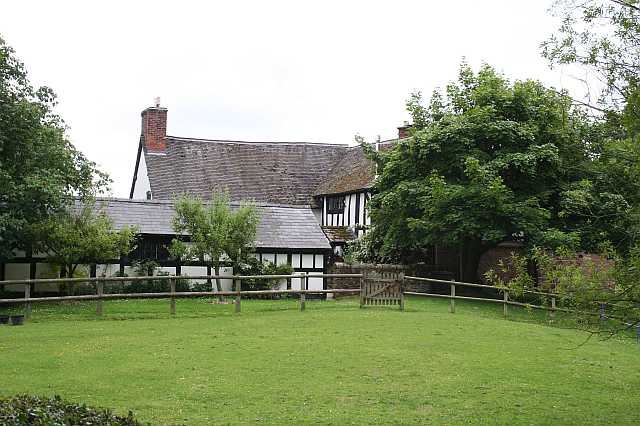
| static_image | Spurstow - Spurstow School.jpg |
| static_image_caption | The former schoolhouse, Spurstow |
| country | England |
| region | North West England |
| unitary_england | Cheshire East |
| lieutenancy_england | Cheshire |
| constituency_westminster | Chester South and Eddisbury |
| civil_parish | Spurstow |
| population | 413 |
| population_ref | (2011 Census) |
| os_grid_reference | SJ558570 |
| coordinates | |
| post_town | TARPORLEY |
| postcode_area | CW |
| postcode_district | CW6 |
| dial_code | 01829 |
Spurstow is a village and civil parish in the unitary authority of Cheshire East and the ceremonial county of Cheshire, England, which is located 6½ miles to the north west of Nantwich. The parish also includes the settlement of Spurstow Sketh and part of Radmore Green. The total population is a little over 400 people. Nearby villages include Bunbury, Haughton and Peckforton. The parish is mentioned in the Domesday Book of 1086 and contains a salt spring, which was formerly used as a spa.
History
Spurstow appears as "Spuretone" in the Domesday Book of 1086; it was then held by Robert FitzHugh, and around 180 acres had been cleared for agricultural use. Remains of a medieval village have been found somewhat to the north west of the existing village of Spurstow, which is believed to have subsequently contracted or moved.
The area was historically important in salt extraction, with an 18th-century brine spa known as Spurstow White Water or Spurstow Spa, which was credited with health-giving effects. The spa still existed in the mid-19th century, when it appeared in the Topographical Dictionary of England (1848) by Samuel Lewis, who wrote "A mineral spring called Spurstow Spa was formerly much frequented, and baths were erected by Sir Thomas Mostyn, for the accommodation of visiters; but the waters are not at present in repute." A school was built by Hungerford Crewe, Lord Crewe in 1872. The village's shop and post office closed in the 1970s, and the school's closure followed in 1983.
Governance
Spurstow is administered by the Spurstow Parish Council. From 1974 the civil parish was served by Crewe and Nantwich Borough Council, which was succeeded on 1 April 2009 by the unitary authority of Cheshire East. Since 2024 Spurstow has been within the parliamentary constituency of Chester South and Eddisbury which is represented by Aphra Brandreth.
Geography and transport
The majority of the civil parish is relatively flat, sloping gently upwards from north to south with an average elevation of around 70–80 metres; the south of the parish, towards Ridley, slopes upwards more steeply, with a high point of around 120 metres.
Demography
According to the 2001 Census, the parish had a population of 394, increasing to 413 in 164 households at the 2011 Census. This represents a decline from the population in 1851 but an increase since 1951; historical population figures are 339 (1801), 562 (1851), 434 (1901) and 323 (1951). The population density was 0.6 persons/hectare in 2011, well below the average of 3.2 persons/hectare for Cheshire East.
Landmarks
The remains of a medieval village are present at near Haycroft, with six house platforms and evidence of medieval ridge and furrow ploughing.
Bath House is a half-timbered house at in Lower Spurstow, dating from the late 16th century, which might have housed visitors to the nearby saline spring. The oldest listed building in the civil parish, it is designated grade II*. Several 17th-century farmhouses and cottages, many of which are also timber framed, are listed at the lower grade of II: Haycroft Farm, Dolphin Cottage, Lower Hall Cottage, Spurstow Hall Cottages, Talbarn (originally a barn), The Butlands and The Cottage in Spurstow village. All that is left of the demolished Lower Spurstow Hall are its grade-II-listed red sandstone gate piers, dating from the late 17th century, which are topped by pineapple-shaped finials.
A former Methodist chapel in chequered brick, dated 1844, stands off Peckforton Hall Lane; it was originally Primitive Methodist. and Spurstow Smithy is a red-brick building with cast-iron lattice windows bearing the Crewe emblem. The 19th-century Spurstow Hall was a model farm on the Crewe estate.
Notable residents
One of the seats of the Aldersey family, Lower Spurstow Hall, was in Spurstow. Notable members of that family who lived in the parish include the explorer Laurence Aldersey (1546–97/8) and Thomas Aldersey (1521/2–1598), a merchant, MP and philanthropist who founded a grammar school in Bunbury.
Education
As of 2016, there are no schools within the civil parish, though the 19th-century Spurstow schoolhouse survives as a grade II listed private house.
References
Sources
- Cheshire Federation of Women's Institutes. The Cheshire Village Book (Countryside Books and CFWI; 1990) ()
- Clare Hartwell, Matthew Hyde, Edward Hubbard, Nikolaus Pevsner. The Buildings of England: Cheshire (Yale University Press; 2011) ()
- Samuel Lewis. A Topographical Dictionary of England (1848)
References
- "Cheshire Towns & Parishes: Spurstow". GENUKI UK & Ireland Genealogy.
- Cheshire Federation of Women's Institutes 1990, p. 203
- "Place name: Spurstow, Cheshire Folio: 264v Great Domesday Book Domesday...". The National Archives.
- "Cheshire L–Z". The Domesday Book Online.
- (May 2002). "Treasure Annual Report 2000". Department for Culture, Media and Sport.
- {{NHLE |num=1018821 |desc=Medieval village and field system remains immediately east of Haycroft |access-date=1 October 2016 }}
- Lewis 1848, pp. 164–70
- "Spurstow Parish Council Parish Council". Cheshire East Council.
- [http://www.opsi.gov.uk/si/si2008/uksi_20080634_en_2#pt2-l1g3 Cheshire (Structural Changes) Order 2008]
- (July 2024). "Location of Chester South and Eddisbury".
- (July 2024). "MPs representing Chester South and Eddisbury".
- "Explorer 257: Crewe & Nantwich: Whitchurch & Tattenhall". Ordnance Survey.
- "2001 Census: Spurstow CP". Office for National Statistics.
- "Civil Parish population 2011". Office for National Statistics.
- {{NHLE
- {{NHLE
- {{NHLE
- {{NHLE
- {{NHLE
- {{NHLE
- {{NHLE
- {{NHLE
- {{NHLE
- {{NHLE
- "Aldersey Family Collection". The National Archives.
- Baldwin, R. C. D.. (January 2008). "Aldersey, Laurence (1546–1597/8)". [[Oxford University Press]].
- Baldwin, R. C. D.. (January 2008). "Aldersey, Thomas (1521/2–1598)". [[Oxford University Press]].
- Spurstow falls within the catchment areas of [[Bunbury Aldersey School. Bunbury Aldersey Church of England Primary School]] in [[Bunbury, Cheshire. Bunbury]] and [[Tarporley High School
- [https://maps.cheshire.gov.uk/cheshirecc.interactivemapping.web.internet/?e=356410&n=355970&mpp=5&layers=BOU.PLA.PLO.PAR.SCH.SSCA&hLayer=&hField=&hValue=®ion=0 Cheshire County Council: Interactive Mapping: Tarporley High School and Sixth Form College] (accessed 5 October 2016)
This article was imported from Wikipedia and is available under the Creative Commons Attribution-ShareAlike 4.0 License. Content has been adapted to SurfDoc format. Original contributors can be found on the article history page.
Ask Mako anything about Spurstow — get instant answers, deeper analysis, and related topics.
Research with MakoFree with your Surf account
Create a free account to save articles, ask Mako questions, and organize your research.
Sign up freeThis content may have been generated or modified by AI. CloudSurf Software LLC is not responsible for the accuracy, completeness, or reliability of AI-generated content. Always verify important information from primary sources.
Report