From Surf Wiki (app.surf) — the open knowledge base
South Dalton
Village in the East Riding of Yorkshire, England
Village in the East Riding of Yorkshire, England
| Field | Value |
|---|---|
| country | England |
| static_image | File:St Mary Dalton Holme 2007.jpg |
| static_image_caption | St Mary's Church seen beyond the village alms houses |
| coordinates | |
| official_name | South Dalton |
| civil_parish | Dalton Holme |
| unitary_england | East Riding of Yorkshire |
| region | Yorkshire and the Humber |
| lieutenancy_england | East Riding of Yorkshire |
| constituency_westminster | Beverley and Holderness |
| post_town | BEVERLEY |
| postcode_district | HU17 |
| postcode_area | HU |
| dial_code | 01430 |
| os_grid_reference | SE966453 |
| london_distance_mi | 165 |
| london_direction | S |
South Dalton is a village and former civil parish, now in the parish of Dalton Holme, in the East Riding of Yorkshire, England. It is situated 6 mi north-east of Market Weighton and 5 mi north-west of Beverley. Etton lies 2 mi to the south-east. North Dalton is 5 mi north-west, with the villages of Middleton on the Wolds and Lund between. In 1931 the parish had a population of 233. On 1 April 1935 the parish was abolished and merged with Holme on the Wolds to form "Dalton Holme".
The village forms part the Dalton Estate, owned and managed by the Hotham family which has possessed land in the area for generations. The 18th-century hall is the home of Lord Hotham. The Dalton Estate office is within the village. The Estate houses are of rows of cottages and Tudor style houses, some with date plates dating as far back as 1706.
According to A Dictionary of British Place Names the village name derives from the Old English for a "farmstead or village in a valley." South Dalton is listed in the Domesday Book as "Delton". At the time of the survey the settlement was in the Hundred of Sneculfcros in the East Riding of Yorkshire. It contained twelve households, twelve villagers, and six ploughlands. In 1066 Ealdred, the Archbishop of York, held the Lordship, this transferring by 1086 to the canons of Beverley, with Thomas of Bayeux, the later Archbishop of York, as Tenant-in-chief to King William I. By 1260 the settlement name was recorded as "Suthdalton".
In 1823 South Dalton was a village and civil parish in the Wapentake of Harthill. Population at the time was 277. Occupations included twelve farmers, a shopkeeper, a boot & shoe maker, a carpenter & wheelwright, a blacksmith, and the landlord of The Board public house. A weaver was also the parish clerk. Three carriers operated between the village and Beverley once a week.
St Mary's Church
The church of St Mary was designated a Grade I listed building in 1968 and is now recorded in the National Heritage List for England, maintained by Historic England. Its spire is over 200 ft tall and is a prominent local landmark. It was designed by John Loughborough Pearson and built from 1858 to 1861 as a replacement for a brick structure.
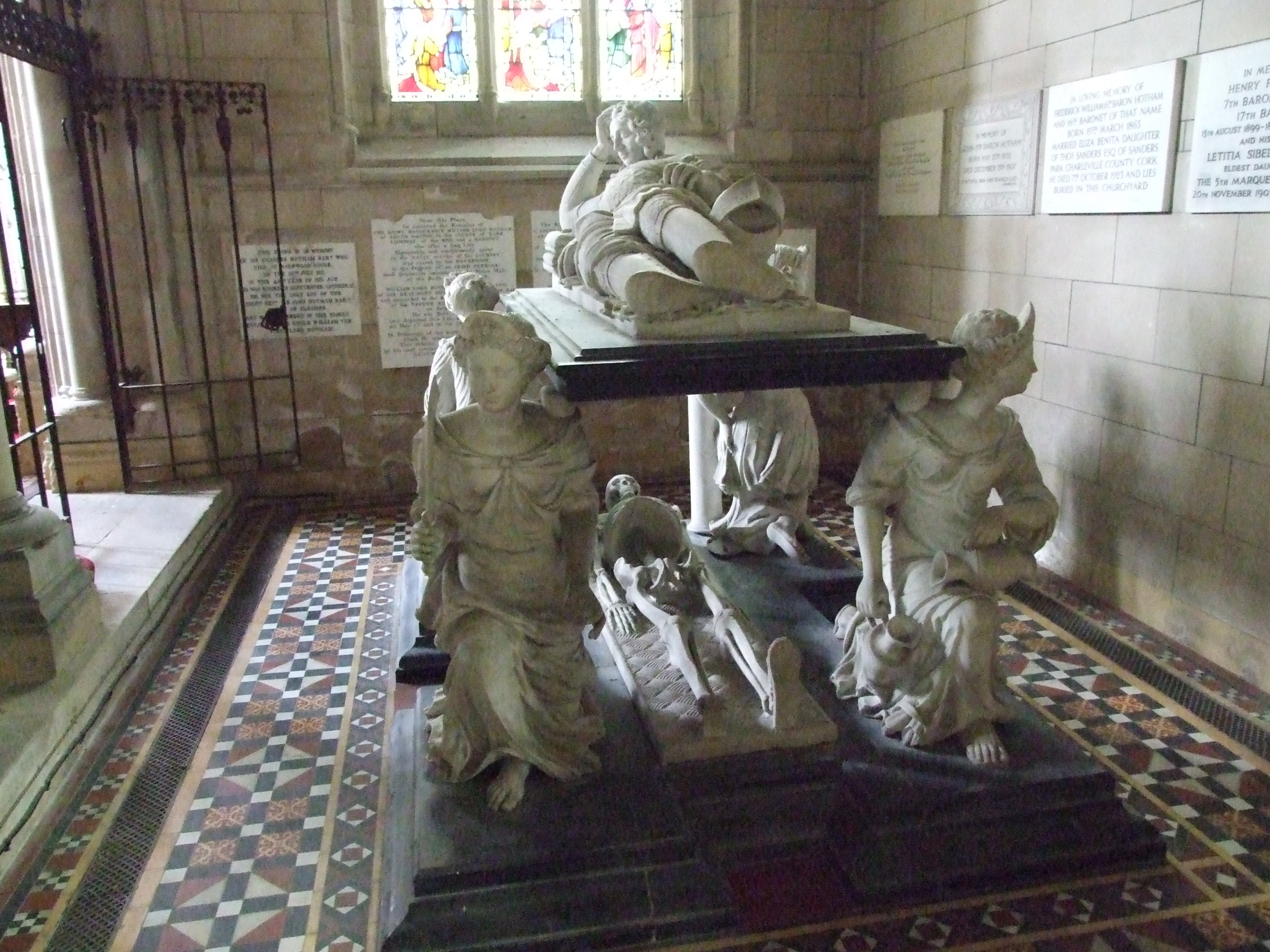
Inside the church lie a number of graves of the Hotham family; the older monuments were transferred from the earlier church. There is a black and white marble monument in memory of Sir John Hotham, 2nd Baronet which is based on the Cecil tomb at Hatfield and dates from after 1697. Sir John is represented in life, as a reclining knight in full armour, with his helmet and gauntlet beside him, and in death, as a skeleton. Supporting the four corners of the tomb are statues representing the cardinal virtues.
The organ is a three manual instrument by William Hill dating from 1877 with additions by the local Hull firm, Foster & Andrews, in 1897.
References
References
- "Population statistics South Dalton AP/CP through time". [[A Vision of Britain through Time]].
- "Relationships and changes South Dalton AP/CP through time". A Vision of Britain through Time.
- Mills, Anthony David (2003); ''A Dictionary of British Place Names'', [[Oxford University Press]], revised edition (2011), p. 146. {{ISBN. 019960908X
- {{OpenDomesday
- [[Edward Baines (1774–1848). Baines, Edward]] (1823): ''History, Directory and Gazetteer of the County of York'', p. 192
- {{NHLE
- [[Nikolaus Pevsner]] & David Neave, (1972, 2nd Ed. 1995), ''Yorkshire: York and the East Riding: The Buildings of England'', {{ISBN. 0-300-09593-7.
This article was imported from Wikipedia and is available under the Creative Commons Attribution-ShareAlike 4.0 License. Content has been adapted to SurfDoc format. Original contributors can be found on the article history page.
Ask Mako anything about South Dalton — get instant answers, deeper analysis, and related topics.
Research with MakoFree with your Surf account
Create a free account to save articles, ask Mako questions, and organize your research.
Sign up freeThis content may have been generated or modified by AI. CloudSurf Software LLC is not responsible for the accuracy, completeness, or reliability of AI-generated content. Always verify important information from primary sources.
Report